| Main | Births etc |
|---|
| Grosthuizen | |||
|---|---|---|---|
| — Hamlet — | |||
|
|||
 |
|||
 |
|||
| Coordinates: Coordinates: | |||
| Country | Netherlands | ||
| Province | North Holland | ||
| Municipality | Koggenland | ||
| Population | |||
| • Total | 400 | ||
| Time zone | CET (UTC+1) | ||
| • Summer (DST) | CEST (UTC+2) | ||
| Postal code | 16xx | ||
| Dialing code | 0229 | ||
| Website | http://www.grosthuizen.nl | ||

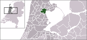
Grosthuizen is a hamlet in the Dutch province of North Holland. It is a part of the municipality of Koggenland, and lies about 7 km southwest of Hoorn.
Grosthuizen was a separate municipality between 1817 and 1854, when it was merged with Avenhorn.[1]
The statistical area "Grosthuizen", which also can include the surrounding countryside, has a population of around 410.[2]
References[]
- ^ Ad van der Meer and Onno Boonstra, "Repertorium van Nederlandse gemeenten", KNAW, 2006. [1]
- ^ Statistics Netherlands (CBS), Statline: Kerncijfers wijken en buurten 2003-2005. As of 1 January 2005.
| This North Holland location article is a stub. You can help by expanding it. |
| This page uses content from the English language Wikipedia. The original content was at Grosthuizen. The list of authors can be seen in the page history. As with this Familypedia wiki, the content of Wikipedia is available under the Creative Commons License. |