| Flint/Tri-Cities | |
| Mid Michigan | |
| Lower Peninsula of Michigan | |
| Country | United States |
|---|---|
| State | Michigan |
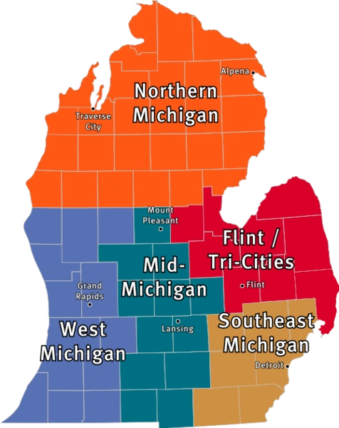 The Flint/Tri-Cities Region is highlighted in red.
| |
The Flint/Tri-Cities Region is a region in the Lower Peninsula of the U.S. state of Michigan. Flint/Tri-Cities has two subregions, The Thumb and the Greater Tri Cities. Flint's population is 102,434, the seventh largest city in Michigan, the combined population of the Greater Tri-Cities (Saginaw, Midland, and Bay City) is 398,482. Genesee, St. Clair and Lapeer counties are located in Detroit–Ann Arbor–Flint Combined Statistical Area.
Economy[]
Straw Bales in an area field
The Flint and Tri-Cities area, as well as most of Michigan is dependent on manufacturing. Automobile manufacturing is most prevalent in Saginaw and Flint, whereas Midland is the headquarters of the Dow Chemical Company, the world's second largest chemical producer. Rural areas grow crops such as sugar beets, navy beans, corn, fruits, and fish from the Saginaw Bay and Lake Huron.
Business[]
Several large corporations have operations in the Tri-Cities. The Michigan Sugar Company, which is a cooperative owned by 1,250 farmers, operates factories in Bay City, Caro, Croswell, and Sebewaing.[1] General Motors operates the Flint Truck Assembly factory in Flint and Powertrain plants in Flint, Bay City, and Saginaw. The Dow Chemical Company's world headquarters is based in Midland. The world headquarters of Nexteer Automotive is located in Saginaw. S.C. Johnson and Son has a manufacturing facility in Bay City making Ziploc products.
Geography[]
- See also List of Michigan state parks and geography of Michigan.
The Thumb
Counties included[]
The Greater Tri Cities[]
The Thumb[]
- Huron County, Michigan
- Tuscola County, Michigan
- Sanilac County, Michigan
- Lapeer County, Michigan
- St. Clair County, Michigan
Geographic features[]
The area has many lakes and rivers.
- Cass River has many branches, one of which flows into the Shiawassee River in the Shiawassee National Wildlife Refuge at less than a mile from where the Shiawassee merges with the Tittabawassee River to form the Saginaw River
- The Saginaw Bay forms a low basin known as the Saginaw Valley, which covers most of the region.
- Lake Huron rests in the far eastern portion of the area, known as the thumb
- St. Clair River, connects Lake Huron to Lake St. Clair, and is the farthest east border in Michigan. It forms a low impression in eastern St. Clair County, and has a delta at its mouth (North America's largest freshwater delta), which includes Harsens Island and Walpole Island, Ontario. Ferries cross the river at Algonac and Marine City, these being international border crossings.
- Flint River Flows through the central and southern portion of Lapeer County, west into Genesee County, and then merges into the Saginaw River.
Transportation[]
Airlines and airports[]
Scheduled airline service is available from MBS International Airport[2] near Midland, Michigan and Flint Bishop International Airport.[3] The only international airport in the thumb area is St. Clair County International Airport about 6 miles outside Port Huron.
Highways[]
Interstate highways[]
 Interstate 69 cuts through the southern area of the region. It starts at the Blue Water Bridge in Port Huron, and runs through Flint.
 Interstate 75 connects this region together. It runs through Bay City, Saginaw, and intersects with I-69 in Flint. I-75 is very busy, bringing commuters north from Metro Detroit to the Mackinac Bridge and into the Upper Peninsula of Michigan.
 Interstate 475
- Interstate 675
U.S. Highways[]
- US-10 bypasses Midland and terminates at I-75 in Bay City, merging into M-25.[4] Viewed from an east-west orientation, it provides a mainly westerly road across Northern Michigan from Bay City off I-75 toward Ludington.
- US-23 comes out of Ohio merges with I-75 south of Flint, and then breaks away at Standish. It then proceeds north, along the Lake Huron shoreline to the Mackinaw City.
Michigan Highways[]
- M-13 is a 72.22 mile north-south highway that cuts through the bay region of the U.S. state of Michigan. The southern terminus is at I-69 south of the town of Lennon with its northern terminus located south of Standish. It is a shorter alternative route, instead of I-75, from Bay City to US 23 in Standish.
- M-15
- M-19
- M-20
- M-21
- old M-21
- M-24
- M-25 is a highway of an arc-like shape closely following the outline of the Thumb along the Lake Huron/Saginaw Bay shoreline between Port Huron, Michigan (junction I-94, I-69, and I-94 Business Loop and Bay City, Michigan (junction I-75, US-23, and US-10.[5] It is generally a scenic drive.
- M-29
- M-30
- M-46 is a cross peninsular road, running across the mitten and the thumb—from Port Sanilac on the Lake Huron shore; through Saginaw near Saginaw Bay; and then on to Muskegon on the Lake Michigan shore.[6] This east-west surface route nearly bisects the Lower Peninsula of Michigan latitudinally.
- M-47
- M-53 (Van Dyke Road) is a gateway route to The Thumb of Michigan, carrying vacationers to the resorts and cottages on Saginaw Bay and Lake Huron in the vicinity of Caseville and Port Austin. It goes up the middle of the Thumb, and directly connects in Macomb County, Michigan to the M-53 expressway. It is an important route for agricultural and manufactured goods.
- M-52
- M-54 The Dort Highway, A main road leading into Flint replaced by I-475
- M-57
- M-58
- M-81
- M-83
- M-84
- M-90
- M-136
- M-138
- M-142
Rail[]
- Main article: Michigan Services
Area Amtrak stations are in Lapeer, Port Huron, Flint and Durand. Local railroads are the Grand Trunk Western Railroad, CSX Transport, Canadian National Rail , Pere Marquette Railway, and the Huron & Eastern Saginaw Valley Railroad.
Media[]


Flint's Genesee Towers
Newspapers[]
- Daily editions of the Detroit Free Press and The Detroit News are available throughout the area.
- Editions of the Bay City Times,[7] Midland Daily News and Saginaw News[8] are available in the greater Tri-Cities area. The Times and the Saginaw News published three times a week, while the Midland Daily News publishes daily. The Great Lakes Bay Edition, a joint publication between the Saginaw News and the Bay City Times, focuses on those two cities, as well as Midland, and publishes once a week.
- The Flint Journal[9] is available in the Flint and Lapeer areas, as well as north Oakland county —it is published four times a week.
- The Huron Daily Tribune serves Huron County; it is published daily.
- The Port Huron Times Herald serves the lower Thumb communities; it is published daily.
Radio[]
The Flint/Tri-Cities area lies within four radio media markets.
- Thumb Radio Region
- Greater Tri-Cities
- Flint Area
- Detroit Area
Broadcast television[]
Television in Tri-Cities and Flint is mostly produced from the Flint/Tri-Cities Television Market. Far eastern areas such as Lapeer County, St. Clair County and Sanilac County lie in the Detroit Television Market. Areas like Genesee County can view programing from the Detroit and Flint/Saginaw media markets.
Availability of stations depend on reception of aerial signals, as well as availability on cable and satellite in a particular area.
Principal cities[]


Port Huron's Blue Water Bridges
- Flint
- Port Huron
See also[]
References[]
- ^ Michigan Sugar Company
- ^ MBS International Airport
- ^ Flint Bishop International Airport
- ^ Bessert, Christopher J.. "US-10". MichiganHighways.org. http://www.michiganhighways.org/listings/MichHwys10-19.html#US-010.
- ^ M-25 end point photos.
- ^ M-46 Endpoint Photos.
- ^ Bay City Times
- ^ Saginaw News
- ^ Flint Journal
External links[]
- Clarke Historical Library, Central Michigan University, Bibliography on Michigan (arranged by counties and regions)
- Michigan Department of Natural Resources website, harbors, hunting, resources and more.
- List of Museums, other attractions compiled by state government.
- "Historic Light Station Information and Photography: Michigan". United States Coast Guard Historian's Office. http://www.uscg.mil/history/weblighthouses/LHMI.asp.
- Map of Michigan Lighthouse in PDF format.
- Seeing the Light, Terry Pepper on lighthouses of the Western Great Lakes.
| |||||||||||||||||||||||||||||||||||

_Panorama.jpg)
| This page uses content from the English language Wikipedia. The original content was at Flint/Tri-Cities. The list of authors can be seen in the page history. As with this Familypedia wiki, the content of Wikipedia is available under the Creative Commons License. |