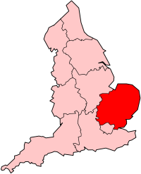
 Eastern region shown within England | |
| Geography | |
|---|---|
| Status | Region |
| Area — Total |
Ranked 2nd 19,120 km² 7,382 sq mi |
| NUTS 1 | UKH |
| Demographics | |
| Population — Total — Density |
Ranked 4th 5,847,000 (2011) 306 /km2 (790 /sq mi) |
| GDP per capita | £{{{gdp}}} ({{{gdp_rank}}}) |
| Government | |
| HQ | Flempton |
| Assembly — Type |
{{{assembly}}} |
| European parliament | East of England |
| Website | |
The East of England is one of nine official regions of England at the first level of NUTS for statistical purposes. It was created in 1994 and was adopted for statistics from 1999. It includes the ceremonial counties of Bedfordshire, Cambridgeshire, Hertfordshire, Essex, Norfolk and Suffolk. Essex has the highest population in the region.
Its population as of the 2011 census was 5,847,000.[1] The area is mostly low-lying, and the highest place is at Clipper Down at 249 m (817 ft) in the far south western corner of the region near to Ivinghoe Beacon in the Ivinghoe Hills.[2] Luton, Basildon, Peterborough, Southend-on-Sea, Norwich, Ipswich, Chelmsford and Cambridge are the region's most populous urban areas. The southern part of the region lies in the London commuter belt.
Geography[]
The area is one of the flattest in the UK. Cambridgeshire is part of The Fens. The lowest point in the UK is Holme Fen, which is 3 metres below sea level.
Historical use[]
| England |
 This article is part of the series: |
|
|
|
Government
English regions
Law and justice
England in the UK
Her Majesty's Government
England in the EU
European Parliament
|
|
Other countries · Atlas Politics portal |
Before the creation of the East of England region there had been a smaller standard statistical region of East Anglia which did not include Essex, Hertfordshire or Bedfordshire. They had previously been included in the South East region. The East of England civil defence region shared the boundaries of the current region.
Common use[]
In common usage the easterly parts of this area have long been, and continue to be known as East Anglia. The areas closer to London are more commonly called part of the South East with Hertfordshire and Essex included in the "Home Counties".
Climate[]
East Anglia is one of the driest parts of the United Kingdom with average rainfall ranging from 450mm to 750mm. This is usually because low pressure systems and weather fronts from the Atlantic have lost a lot of their moisture over land (and therefore are usually a lot weaker) by the time they reach Eastern England. However The Fens in Cambridgeshire is prone to flooding should a strong system affect the area.
Winter (mid November - mid March) is mostly cool but cold easterly winds can affect the area from the continent, these can bring occasionally heavy snowfall if the winds interact with a low pressure system from the Atlantic or the Mediterranean. Northerly winds can also be cold but are not usually as cold as easterly winds. Westerly winds usually bring milder but wetter weather. Southerly winds can also be mild (esp if they come from the Mediterranean or North Africa) but can also be chilly if coming from mainland Europe.
Spring (mid March - May) is a transitional season that can be chilly to start with but is usually warm by late-April/May. The weather at this time can be changeable and occasionally showery.
Summer (June - mid September) is usually warm & pleasant but continental air from mainland Europe or the Azores High can occasionally lead to hot and muggy weather. Westerly winds from the Atlantic can make the area cool and unsettled.
Autumn (mid September - mid November) is usually mild but can be changeable with some days being very unsettled and rainy and others being relatively warm & pleasant. An Indian summer can occasionally take place with September and early October having warm and settled weather.
Demographics[]
Teenage pregnancy[]
For regions in England, the East of England has the lowest overall teenage pregnancy rate. Inside the East of England, the top-tier authority with the highest rate is Peterborough. The council district with the highest rate is Norwich closely followed by Great Yarmouth. For top-tier authorities, Hertfordshire has the lowest rate of teenage pregnancy. For council districts, Uttlesford in north-west Essex has the lowest rate.
Deprivation[]
The most deprived districts, according to the Indices of deprivation 2007 in the region are, in descending order, Great Yarmouth (58th in England), Norwich (62nd), Luton (87th), Peterborough (90th), and Ipswich (99th). At county level, after Luton and Peterborough, which have a similar level of deprivation, in descending order there is Southend-on-Sea then Thurrock.
The least deprived districts, in descending order, are South Cambridgeshire, Uttlesford, Mid Bedfordshire, East Hertfordshire, St Albans, Brentwood, Rochford, Chelmsford, Huntingdonshire, Mid Suffolk, Broadland, North Hertfordshire, Dacorum, Three Rivers, South Norfolk, East Cambridgeshire and Suffolk Coastal. At county level, the least deprived areas in the region, in descending order, are Cambridgeshire, Hertfordshire and Bedfordshire, with all three having a similar level of deprivation, then Essex.[3]
The region has the lowest proportion of jobless households in the UK - 0.5%.
In March 2011 the region's unemployment claimant count was 3.0%. Inside the region, the highest rate is Great Yarmouth with 6.2%, followed by Peterborough, Ipswich and Southend-on-Sea on 4.7%.[4]
Elections[]
In the 2010 general election, there was an overall swing of 0.8% from the Liberal Democrats to the Conservatives, and Labour lost 10% of their vote.[5] All of Hertfordshire and Suffolk is now Conservative. The region's electorate voted 47% Conservative, 24% Liberal Democrat, 20% Labour and 4% UKIP. Like other regions, the division of seats favours the dominant party in the region, and the Conservatives have 52, Lib Dems 4 (also Norwich South, Colchester and Cambridge) and Labour 2 (Luton South and Luton North).
Template:Constituencies in the East of England
Eurostat NUTS[]
In the Eurostat Nomenclature of Territorial Units for Statistics (NUTS), the East of England is a level-1 NUTS region, coded "UKH", which is subdivided as follows:
| NUTS 1 | Code | NUTS 2 | Code | NUTS 3 | Code |
|---|---|---|---|---|---|
| East of England | UKH | East Anglia | UKH1 | Peterborough | UKH11 |

|
Cambridgeshire CC | UKH12 | |||
| Norfolk | UKH13 | ||||
| Suffolk | UKH14 | ||||
| Bedfordshire and Hertfordshire | UKH2 | Luton | UKH21 | ||
| Hertfordshire CC | UKH23 | ||||
| Bedford | UKH24 | ||||
| Central Bedfordshire | UKH25 | ||||
| Essex | UKH3 | Southend-on-Sea | UKH31 | ||
| Thurrock | UKH32 | ||||
| Essex CC | UKH33 | ||||
Governance[]
Regional government[]
An East of England Regional Strategy Board exists to co-ordinate the work of the local councils in the area and provides other functions. It is based in Flempton on the A1101 north-west of Bury St Edmunds. The Government shut the Government office for the East of England in 2011, the East of England Development Agency is being closed also. The East of England also elects MEPs for the East of England (European Parliament constituency).
East of England Plan[]
The current version of the East of England Plan, a Revision of the Regional Spatial Strategy for the East of England, was published on 12 May 2008. It was revoked on 3 January 2013[6]
Local government[]
The official region consists of the following subdivisions:
| Map | Ceremonial county | Shire county / unitary | Districts |
|---|---|---|---|
 |
Essex | 1. Thurrock U.A. | |
| 2. Southend-on-Sea U.A. | |||
| 3. Essex | a) Harlow, b) Epping Forest, c) Brentwood, d) Basildon, e) Castle Point, f) Rochford, g) Maldon, h) Chelmsford, i) Uttlesford, j) Braintree, k) Colchester, l) Tendring | ||
| 4. Hertfordshire | a) Three Rivers, b) Watford, c) Hertsmere, d) Welwyn Hatfield, e) Broxbourne, f) East Hertfordshire, g) Stevenage, h) North Hertfordshire, i) St Albans, j) Dacorum | ||
| Bedfordshire | 5. Luton U.A. | ||
| 6. Bedford U.A. | |||
| 7. Central Bedfordshire U.A. | |||
| Cambridgeshire | 8. Cambridgeshire | a) Cambridge, b) South Cambridgeshire, c) Huntingdonshire, d) Fenland, e) East Cambridgeshire | |
| 9. Peterborough U.A. | |||
| 10. Norfolk | a) Norwich, b) South Norfolk, c) Great Yarmouth, d) Broadland, e) North Norfolk, f) King's Lynn and West Norfolk, g) Breckland | ||
| 11. Suffolk | a) Ipswich, b) Suffolk Coastal, c) Waveney, d) Mid Suffolk, e) Babergh, f) St. Edmundsbury, g) Forest Heath | ||
History[]
Second World War[]
Norfolk, Suffolk and Essex played host to the American VIII Bomber Command and Ninth Air Force. The Imperial War Museum has a museum, commemorating their participation and sacrifice, near to the M11 south of Cambridge.
Stansted Airport was RAF Stansted Mountfitchet, home to the 344th Bombardment Group. The de Havilland Mosquito was mainly assembled at Hatfield and Leavesden, although much of the innovative wooden structure originated outside the region from the furniture industry of High Wycombe.
Scientific heritage[]
Watson and Crick discovered the structure of DNA at Cambridge in 1953. At the Bourn Hall Clinic in Bourn, west of Cambridge, in vitro fertilisation (IVF) was first achieved in 1978. At the Rothamsted Experimental Station, near Harpenden in Hertfordshire, 2,4-D was discovered, under Juda Hirsch Quastel; this is the most widely used herbicide in the world. Later at the station, the pyrethroid insecticide was developed, under Michael Elliott, which is now the most common insecticide on the domestic market. Smith, Kline and French developed Tagamet in 1970s at The Frythe, north of Welwyn, for which Sir James W. Black received the 1988 Nobel Prize for Medicine; the site was sold by GSK December 2010.
Radar was developed in around Chelmsford in the late 1930s and at Bawdsey Manor on the Suffolk coast. Earlier radio had been developed around Chelmsford by the Marconi Company; much of Britain's electronics industry was derived from Marconi, later to be GEC and now BAE Systems.
Industrial heritage[]
Ransomes, Sims & Jefferies of Ipswich built the first engine-powered commercial lawnmower in 1902. The firm would later own Mountfield.
De Havilland built the Comet (the world's first jet airliner, powered by DH jet engines) at Hatfield, and built the Blue Streak rocket launcher at its Stevenage base.
Sinclair Research was based in Cambridge, as was its competitor in the 1980s, Acorn Computers. Sizewell B is Britain's only pressurized water reactor (PWR), and is near Leiston in Suffolk. Sir Christopher Cockerell (born in Cambridge) developed the hovercraft on Oulton Broad, Suffolk in 1956.
Culture[]
Benjamin Britten and John Constable were from Suffolk. The poet Jane Taylor wrote the words for Twinkle Twinkle Little Star in 1806 in Lavenham, Suffolk. Dad's Army was filmed in Thetford. The Planets was composed by Gustav Holst when he lived in Thaxted (in north-west Essex) which gave its name to a hymn tune. Emneth, near Wisbech, was the home of Rev Wilbert Awdry when he wrote his famous children's books, The Railway Series; he had earlier lived in Elsworth, west of Cambridge.
Economy[]
The former electricity company for the area, Eastern Electricity, has the area's distribution now looked after by EDF Energy Networks at Fore Hamlet in Ipswich. EDF also look after London and most of the South-East. Business Link in the East of England is next door to the headquarters of T-Mobile UK in Hatfield, at the roundabout of the A1057 and the A1001 on the Bishops Square Business Park.[7][8] The region's Manufacturing Advisory Service is at Melbourn in Cambridgeshire, off the A10 and north of Royston.[9] UKTI for the region is in Histon[10] with its international trade team based next to Magdalene College.
NHS East of England, the strategic health authority for the area, is on Capital Park, next to Fulbourn Tesco, Fulbourn Hospital, and the Cambridge-Ipswich railway, on the eastern edge of Cambridge. The East of England Ambulance Service is on Cambourne Business Park on Cambourne, off the A428 (former A45) west of Cambridge. The East Anglian Air Ambulance operates from Cambridge Airport and Norwich Airport; Essex Air Ambulance operates from Boreham.
Hertfordshire[]

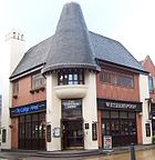
Wetherspoons is based in Watford near Watford Junction railway station
The Greater Watford area is home to British Waterways, Vinci UK (who bought Taylor Woodrow Construction in 2008), the UK of the international firm Total Oil, retailers TK Maxx, Bathstore, Majestic Wine, Mothercare, Costco UK, and Smiths Detection, Iveco UK, BrightHouse (at Abbots Langley), Leavesden Film Studios, Sanyo UK, Europcar UK, Olympus UK, Kenwood and Beko electronic goods manufacturers, Wetherspoons pub chains, the European HQ of the Hilton hotel group and Nestlé Waters; in Garston is the UK headquarters of the Seventh-day Adventist Church, on the A412, and the Building Research Establishment. Comet Group and Camelot Group (owners of the National Lottery), on the A4145, are in Rickmansworth. Ferrero UK (maker of Nutella and Kinder Chocolate) is in Croxley Green. Renault UK and Skanska UK (construction) are in Maple Cross.
In Elstree and Borehamwood (close to the A1 motorway) are the Elstree Studios, where the Star Wars films were made and more recently Big Brother, and Hasselblad UK is based in Elstree. Borehamwood is also home to BBC Elstree and Pizza Hut UK. The Boy's Brigade, Dixons Retail (owners of Currys) and PC World), Sir Robert McAlpine, Bourne Leisure are based in Hemel Hempstead; where 3Com, Epson UK, Steria (formerly Bull and Honeywell), Alcon UK, and Kodak have their UK bases. Henkel UK make (Loctite) industrial adhesives off the A4147, next to Dixons. Pure Digital (DAB radios) are in Kings Langley, with its parent company Imagination Technologies who are a world-leading designer of microprocessors. The town was former home of Ovaltine until 2002. Noble Foods on the B488 in Tring is the UK's biggest producer of eggs.


T-Mobile (former Mercury One2One) UK HQ in Hatfield next to the A1 on the site of the former factory of de Havilland
In Welwyn Garden City are PayPoint, the former headquarters of First Quench Retailing until 2009 (formerly the Thresher Group), Hostelling International, the UK headquarters of Xerox, Cereal Partners, DBC Foodservice, and Hoffmann–La Roche. Shredded Wheat and Shreddies were manufactured in the town by Nestlé (Cereal Partners) until April 2008, which has its UK headquarters at the A1000/B195 junction. DuPont UK and a plant of GSK are in Stevenage. EADS Astrium UK, with Paradigm Secure Communications (a satellite operator) (who have made parts for the ExoMars mission, Gaia (spacecraft), ADM-Aeolus, and LISA Pathfinder) and MBDA UK (former de Havilland Propellers, then BAe Dynamics) are near the A1(M) bypass opposite each other on the A1072. Tesco and Crompton Lighting are based in Cheshunt. Computacenter, Denso UK, and EE are in Hatfield; Veolia Water Central Limited and the HQ of Ocado are next to each other on the A1001. Polaroid UK (near the railway bridge over the A1081), Burton's Biscuit Company (on the B691), and Premier Foods are in St Albans; also Murphy Oil Corp's USA, UK subsidiary, Murco Petroleum Ltd; The Cloud (wifi hotspots, owned by BSkyB), is next to the railway station. Viglen is on the A5183 (former A5) next to the M25 and railway at Ventura Park, the former site of Handley Page at Colney Street (St Stephen).
Johnson Matthey (materials for catalytic converters) has its main operations in Royston. Royde & Tucker in Hitchin, Herts is the UK's leading manufacturer of door hinges, and William Ransom & Son make pharmaceuticals and natural remedies. Cash Converters UK is in Thundridge near Ware. News International has the world's largest printing press at Broxbourne (Waltham Cross). Harlow has Pearson Education, the main research division of GlaxoSmithKline (on a former BP site), the European headquarters of Pitney Bowes, Synthomer (polymers), and the main manufacturing plant of Raytheon UK. Rexel UK (electrical supplies) is based at the A111/A1000 junction in Potters Bar.
Bedfordshire[]


Samuel Whitbread began his brewery in Bedfordshire in 1742
Moto Hospitality have their headquarters at Toddington in Bedfordshire (at the service station).
Luton is home to EasyJet, Monarch Airlines (both based at the airport), Hain Celestial Group UK (who make Linda McCartney Foods, and are based on the B579 in Biscot), Eurolines (UK office), Thomson UK (based at Wigmore on the eastern edge of the town), and Chevrolet UK (at Griffin House, the Vauxhall head office). At the 85-acre Capability Green off the A1081 and junction 10a of the M1, is the Stonegate Pub Company (owner of Scream Pubs, Yates's, Slug and Lettuce and Hogshead), InBev UK (which bought most of Whitbread's beer brands), Chargemaster (electric vehicle network under the POLAR brand), AstraZeneca's UK Marketing Company division, and Alexon Group (ladies clothing). Vauxhall produced its last Vauxhall Vectra in March 2002 at the plant near the A6/A505 roundabout, and now makes vans (Vivaro/Renault Trafic) at the former Bedford Vehicles plant, based in the north of the town at the GM Manufacturing Luton plant. Near Luton railway station, Comau Estil is a manufacturing systems integrator for car manufacturers. Elster Metering make gas and electricity meters, and are based in the north of Luton on the opposite side of the railway to Vauxhall. GKN Aerospace Transparency Systems (former Pilkington Aerospace before 2003), the world's leading manufacturer of military aircraft canopies, which also makes ice protection systems, is at Luton Airport. ArjoHuntleigh, based on the A505 in Luton near the M1, are a leading medical equipment manufacturer, and nearby, Certwood made the plastic seats for London's Olympic Stadium. Premier Inn (owned by Whitbread) is headquartered, with the UK headquarters of Electrolux (owner of AEG and Zanussi), in Leagrave, north Luton. Its neighbour in Dunstable is home to Whitbread, and Polestar, a main magazine printers.


Wigmore House in Luton, home of TUI UK, and Thomson Airways, the world's largest charter airline
Bedford is home to Fujifilm UK and Wells & Young's Brewery (former Charles Wells). Danfoss Randall make heating controls on the A6 next to Bedford St Johns railway station, and boxclever is south of the town on the A6. Autoglass is in nearby Cardington.
Hunter Engineering UK (defence) is at Ampthill. Amazon UK have their main distribution centre for England (their first in the UK in May 1999)[11] at the ProLogis Marston Gate[12] site at Brogborough near junction 13 of the M1 (A421) next to Ridgmont railway station. Hanson Building Products was the largest producer of aggregates in the world, being taken over by HeidelbergCement in August 2007, and has always been based at Stewartby off the A421 south of Bedford next to the railway station. Kier Group and the RSPB are in Sandy. Connells and UltraVision are in Leighton Buzzard. Leisure Connection is in Wyboston, towards St Neots. Jordans (cereal), AMG Systems (electronics) and Liebherr Group UK are in Biggleswade. Trafficmaster Europe and Saab Great Britain are at Cranfield University. Unilever have their main food research site (where low fat spreads were invented) at Colworth Science Park near Sharnbrook.
East Anglia[]
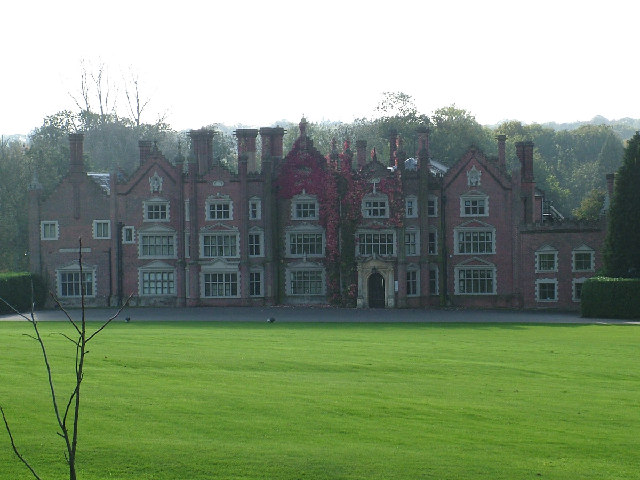
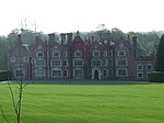
Great Witchingham Hall, the headquarters of Bernard Matthews Farms, north-west of Norwich at Great Witchingham on the A1067
The economy in Norfolk, Cambridgeshire and Suffolk is traditionally mostly agricultural. Norfolk is the UK's biggest producer of potatoes. Nationally known companies include the RAC, Archant (publishing), Virgin Money and Aviva (formerly Norwich Union) in Norwich. In Carrow, to the east of the city, Colman's make a wide range of mustards, and Britvic make Robinsons squash, which was owned by Colman's until 1995. Across the River Yare near the A47/A146 junction in Trowse with Newton is May Gurney, the construction company. Bernard Matthews Farms have a large turkey farm on the former RAF Attlebridge in Weston Longville. Campbell Soup was made in Kings Lynn until 2008, and on the Hardwick Industrial Estate at the A47/A149 junction are PinguinLutosa UK, who pack frozen vegetables, and Caithness Crystal. Foster Refrigerator is the UK's leading manufacturer of commercial refrigerators and blast chillers, owned by Illinois Tool Works, based on the industrial estate, with Multitone Electronics, who have a manufacturing plant there, and who invented the pager in 1956, for St Thomas' Hospital, and Snap-on Diagnostics make diagnostic tools for garages. Linda McCartney sausages are made by Hain Celestial Frozen Foods at Fakenham, where Kinnerton Confectionery produces around 6000 tonnes of chocolate each year, which is mostly private label (supermarket) products. British Sugar's Wissington is the world's largest sugar beet factory in Methwold, on the B1160 near the River Wissey. Lotus Cars and Team Lotus are on the eastern edge of the former RAF Hethel, east of Wymondham (A11) at Hethel (Bracon Ash). Jeyes Group make household chemicals in Thetford, off the A134; Multiyork make furniture and Baxter Healthcare have a manufacturing plant in the south of the town. Aunt Bessie vegetable products (roast potatoes) are made by Heinz UK at Westwick, in a factory built by Ross Group.
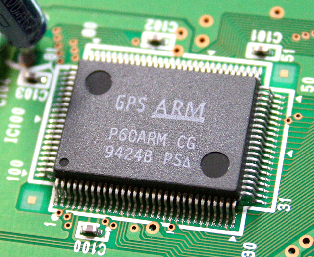

ARM CPU designed in Cambridge
Around Cambridge on numerous science parks, are high technology (electronics and biochemistry) companies, such as ARM Holdings on Peterhouse Technology Park in the south-east of the town, Adder Technology (KVM switches) at Bar Hill at the A14/B1050 junction north of the town, Monsanto UK, Play.com on the Cambridge Business Centre. The Wellcome Trust Genome Campus has the European Bioinformatics Institute at Hinxton east of Duxford near the M11 spur for the A11. These form the so-called Silicon Fen. Marshall Aerospace is at Cambridge Airport on the A1303 in the east of the town, towards Teversham. South of the airport, Carl Zeiss NTS make scanning electron microscopes in Cherry Hinton. Syngenta UK is to the east of Cambridge, on Capital Park at Fulbourn. Premier Foods have a large plant in Histon and Impington making Robertson's and Hartley's jam, Gale's honey, Smash instant potato, and Rose's marmalade. Addenbrooke's Hospital is a pioneering hospital in the UK, based at Cambridge Bio-Medical Campus. On the Cambridge Science Park (in Milton), the first science park in Europe (when founded in 1970 by Trinity College), near the junction of the A14 and A10 (A1309) and on the western side of the A1309 in South Cambridgeshire, are WorldPay (payment service provider), Jagex Games Studio (RuneScape), the European HQ of Accelrys, Cambridge Consultants, Astex (biotechnology), Kodak's European R&D centre, and Broadcom UK. On Cambridge Business Park, on the eastern side of the A1309 (former A10) and inside the district of Cambridge, are Autonomy Corporation, an FTSE-100 company, Red Gate Software, CSR plc, and NEC Unified Solutions UK (unified communications). On the 200-acre Granta Park at Great Abington near the A1307/A11 junction south of Cambridge are MedImmune (former Cambridge Antibody Technology, now owned by AstraZeneca) who research antibodies. The Welding Institute, Pfizer Regenerative Medicine, Gilead Sciences and PPD are nearby. The science park has its own cricket pitch.
Cambridgeshire has a few RAF bases. Subway UK (restaurants) is in Great Shelford. Unwins Seeds is in Alconbury Weston next to the A1. Avanquest UK, the home software company who bought EMME (who bought GSP in 2000) in 2007, is in St Ives, off the A1096. Nestlé Purina PetCare make petfood at its South Brink factory in Wisbech, with another in Sudbury, Suffolk. Princes (formerly owned by Premier Foods before February 2011) can vegetables and baked beans, and make Loyd Grossman cooking sauces in the town. Lamb Weston (potato products) are on the Weasanham Lane Ind Estate in the south of Wisbech, and next door Del Monte can fruit. On the Middle Level Main Drain at Marshland St James, south of Wisbech, Herbert Engineering are Britain's main producer of potato graders. The main water company for the area, AWG plc and International Audio Group are based in Huntingdon. JDR Cable Systems make underwater cables at the A10/A1101 roundabout at Littleport. McCain Foods have a factory (which was the largest frozen food factory in the world when it opened in 1976, processing 200,000 tonnes of potatoes annually) on the A605 and railway, near London Brick, at Whittlesey, towards Peterborough.


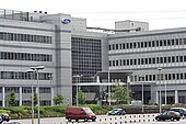
Thomas Cook headquarters, next to the East Coast Main Line in Bretton, Peterborough
RAF Wittering was the home of the Harrier from August 1969 until December 2010, and now houses Army personnel, along with the RAF Regiment. British Sugar, Silver Spoon and the Billington Food Group are based near each other in Peterborough, as is Perkins Engines (diesel engines). News International have a main office there and Indesit (owner of Hotpoint, previously owned by GEC before 2007) have their UK headquarters in Woodston. Next door is Applied Energy Products (part of Glen Dimplex), which owns Redring, Credair and Xpelair. The N&P Building Society (since November 2011 part of the Yorkshire Building Society) is in Orton Northgate. Bauer Radio and Bauer Consumer Media (former EMAP Consumer Media) are headquartered on Lincoln Road. EMAP have their magazine headquarters off the A605 in Orton Wistow, and BGL Group (Compare The Market) is in Orton Southgate next to the Peterborough services. Ronart Cars and Radical Sportscars develop sports cars at Westwood. Baker Perkins makes food processing equipment next to the Paston Parkway (A15) in Gunthorpe.


Gate guard at RAF Lakenheath
The USAF still have bases in Suffolk. Johnsons and Mr Fothergill's make seeds in Kentford, off the A14. In Newmarket is the base of the British horse racing industry and the National Horseracing Museum. CLAAS UK, is based on the side of the A14 just west of Bury St Edmunds at The Saxhams, Zetor Tractors UK is in Downham Market, and New Holland UK (and also the UK base of Fiat-owned CNH Global) is in Basildon where there is a large tractor factory. The RAF Regiment is based at RAF Honington, between the A1088 and A134, south of Thetford, partly in Fakenham Magna. The 100th Air Refueling Wing, which flies the KC-135 is at RAF Mildenhall. Silverline are a main maker of steel office furniture (filing cabinets and tambour desks) in Mildenhall, next to airfield. Greene King and Branston Pickle are in Bury St Edmunds, and British Sugar make all their icing sugar and caster sugar there. Helmsman is the UK's leading manufacturer of changing room cubicles and lockers, based on the A1101 at Fornham All Saints, north of Bury St Edmunds. Vinten make camera supports next to the A14, and are part of the Vitec Group. BT Research have had their main labs at Adastral Park near Martlesham Heath, off the A12, since 1975. This site now claims to be the largest software development centre in Europe. Essfoods are based at Rendlesham Hall off the A1152, near the former RAF Bentwaters. BOCM Pauls is in Wherstead just south of Ipswich. Ransomes Jacobsen (part of Textron) make sit-down lawn mowers on the Ransomes Europark near the A14/A1189 junction. The Port of Felixstowe is the UK's busiest container terminal and the 28th busiest in the world. Birds Eye, now no longer part of Unilever, now has its main factories in Lowestoft near Ness Point, and LEC Marine who make switchboards. SLP Engineering who make gas platforms for the North Sea. Adnams Brewery is on the Suffolk coast at Southwold. The electricity supplier Haven Power is based in Ipswich. Thompson and Morgan make seeds, west of Ipswich just off the A14 at Sproughton. Becker Acroma (part of Sherwin-Williams) make wood finishes off the A1017 in Haverhill, and on the same industrial estate IFF make fragrances, and Marchant Manufacturing make polythene (retail) bags.
Essex/Greater London[]

Ford of Europe's Dunton Technical Centre
The Scout Association is headquartered in Gilwell Park in south Essex. Konica Minolta Business Solutions (UK), Muddy Fox (mountain bikes) and SELEX Galileo (former BAE Systems Avionics) are in Basildon, and MK Electric makes circuit protection systems, and is based at Cranes near the A127/A132 junction, with a factory at Southend. Britvic is on the A1016 in Chelmsford, which is the historic home of the Marconi Company now run by BAE Systems at Great Baddow. Federal Express Europe Inc is at Stansted Airport. Clarke International, who make electrical power equipment and tools, are on the B1393 (former A11) in Epping. Clinton Cards is in Loughton, where De La Rue has a banknote printing factory next to junction 5 of the M11, printing notes for the Bank of England and other countries. Countrywide plc is in Witham, Essex.
The army have a large base in Colchester, which is the home of the Parachute Regiment and 16 Air Assault Brigade. In the east of Colchester, off the A134 is MAN Diesel & Turbo UK, formerly owned by Paxmans, who built the diesel engines for most UK trains, and further south in the town at Hythe there is Chandos Records.
JobServe and Wilkin & Sons (jam and marmalade) are in Tiptree. Arla Foods make (filtered) Cravendale milk at Hatfield Peverel. In Little Clacton, Syngenta breeds beneficial insects (mostly bumblebees) for use worldwide. Dalau in Clacton is Britain's main producer of PTFE (Teflon). Martin McColl, the newsagents group, and Amstrad are in Brentwood, home to Ford of Europe at Warley, and the Dunton Technical Centre at Dunton Wayletts next to the A127.
In Thurrock are Harveys Furniture and Carpetright in Purfleet, and Unilever have a large margarine works there. P & G make soap (detergents) in West Thurrock.
Hi-Tec (sports equipment, founded in Shoeburyness) is at London Southend Airport. Olympus KeyMed near the A1159/A127 Cuckoo Corner roundabout in Southend makes medical ultrasound equipment and endoscopes.
Transport[]
Transport policy[]


M11 near Cambridge
As part of the transport planning system the Regional Assembly is under statutory requirement to produce a Regional Transport Strategy (RTS) to provide long term planning for transport in the region. This involves region wide transport schemes such as those carried out by the Highways Agency and Network Rail.[13]
Within the region the local transport authorities carry out transport planning through the use of a Local Transport Plan (LTP) which outlines their strategies, policies and implementation programme.[14] The most recent LTP is that for the period 2006-11. In the East of England region the following transport authorities have published their LTP online: Bedfordshire,[15] Cambridgeshire,[16] Essex,[17] Hertfordshire,[18] Luton U.A.,[19] Norfolk,[20] Peterborough U.A.,[21] Southend-on-Sea U.A.,[22] Suffolk,[23] Thurrock U.A.[24] Since 1 April 2009, when the county of Bedfordshire was split into two unitary councils,[25] the Bedfordshire transport authority has ceased to exist, however it is the most recent LTP for the area.
Road[]

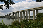
The Orwell Bridge
The East of England region is covered by the Highways Agency operational area 6 and part of area 8. Major roads servicing these areas include the M1 Luton to Milton Keynes, M11 London to Cambridge, M25 through Essex, A1 London to Peterborough, A5 St. Albans to Milton Keynes, A11 London to Norwich, A12 London to Great Yarmouth, A14 Felixstowe to Rugby via Cambridge, A47 Great Yarmouth to Nuneaton and the A120 Harwich to Stansted. There are a number of proposed road developments throughout the region.
Rail[]
The region is serviced by Network Rail Route 5 West Anglia and Route 7 Great Eastern as well as parts of Route 6 North London Line and Thameside, Route 8 East Coast Main Line and Route 18 West Coast Main Line. Major rail lines run London to Norwich, London to Cambridge and King's Lynn, and London to Southend with a number of rural branch lines servicing the wider region. A major freight route also runs between the Port of Felixstowe and London.
Sea[]


Felixstowe
The East of England has one international ferry port, Harwich International Port, which together with the Port of Felixstowe, the UK's largest container port, and the Port of Ipswich forms the Haven ports group. The East of England coast also holds a number of traditional fishing ports including the King's Lynn Docks, the Port of Lowestoft and Wells Harbour. There are also a number of ports on the Essex side of the Thames Estuary and river including Shell Haven and the Port of Tilbury.
Great Yarmouth Outer Harbour opened in 2010 and along with the Port of Lowestoft provides support for the North Sea energy industry, including the growing off-shore wind energy sector.
Air[]


Stansted is Ryanair's biggest hub with 108 routes
The region has three public international airports, London Stansted Airport (former RAF Stansted Mountfitchet), London Luton Airport and Norwich International Airport (former RAF Horsham St Faith). It also includes a number of smaller local airfields that are licensed for the public transport of passengers or for flying instruction these include Beccles Airport, Clacton Airport, Duxford Aerodrome and Peterborough/Sibson Airport.
There is a current proposal to expand the capacity of Stansted Airport. In March 2008 BAA Limited submitted a planning application for the construction of a second runway and terminal at the site. This has faced opposition from the Stop Stansted Expansion pressure group whose members believe the development is unsustainable. Stansted Airport has the unenvious position of being the UK's airport of choice for hijacked planes entering the UK's airspace, and as a result has seen some high profile hijackings in recent years.
Education[]


Clare College Bridge at the University of Cambridge
There are around 255,000 at the region's secondary schools. The region overall has a low truancy rate. Within the region, Great Yarmouth has the highest truancy rate with 6.7% persistent truants, followed by Fenland (Cambridgeshire) with 6.3%. St Edmundsbury (Suffolk) has the lowest persistent truancy rate with 2.0%.
Essex and Southend-on-Sea LEAs have selective schools. The others do not. Eight out of the top ten schools in the region (by A level results) are either in Essex or Southend-on-Sea. However, at GCSE, the best performing LEA is Hertfordshire, followed by Southend-on-Sea and Cambridgeshire. Essex, Central Bedfordshire, and Thurrock also perform better than the England average of 53.4% attaining 5 grades A-C including Maths and English. In general, the region performs well at GCSE, with only Peterborough being low performing. Thurrock and Luton were generally next lowest areas, but have improved. The area has 16 Academies.
At A level in 2010, the best performing area is Essex, followed closely by Cambridgeshire, and Suffolk (around the England average). Hertfordshire in 2010, with its excellent GCSE results, was not even above the England average at A level. Peterborough is the least performing area, followed closely by Luton, and Bedford. At A level, Norfolk does not perform well for a rural county. The Colchester Royal Grammar School is consistently the best school in England at A level. The region has 225 school sixth forms. For such an affluent area, the region's performance at A level is less than would be expected.
School children in Hertfordshire are proportionately most likely to go to university, followed by Cambridgeshire and Bedfordshire. Hertfordshire pupils are also most likely to stay on in education at 16.
There are twenty seven FE colleges (FECs) in the region.[26] The largest FE college is Suffolk New College. The YPLA[27] regional office is based in Stoke, Ipswich, off the A137 next to Cliff Quay.
Top thirty state schools in the East of England (2010 A level results)[]


Wymondham College
Sir John Lawes School
- 1. Colchester Royal Grammar School (1366)
- 2. King Edward VI Grammar School (Chelmsford)
- 3. Hockerill Anglo-European College, Bishop's Stortford
- 4. Chelmsford County High School
- 5. Southend High School for Girls
- 6. Southend High School for Boys
- 7. Westcliff High School for Boys, Westcliff-on-Sea
- 8. Colchester County High School
- 9. St Benedict's Roman Catholic Upper School, Bury St Edmunds
- 10. St Alban's Catholic High School, Ipswich
- 11. The King's School, Peterborough
- 12. Wymondham High School
- 13. Westcliff High School for Girls, Westcliff-on-Sea
- 14. Hills Road Sixth Form College, Cambridge
- 15. Watford Grammar School for Boys
- 16. Farlingaye High School, Woodbridge, Suffolk
- 17. St John Payne Catholic Comprehensive School, Chelmsford
- 18. Sir John Lawes School, Harpenden
- 19. Wymondham College
- 20. Dame Alice Owen's School, Potters Bar
- 21. The Sixth Form College Colchester
- 22. Loreto College, St Albans
- 23. Roundwood Park School, Harpenden
- 24. The Boswells School, Chelmsford
- 25. Thorpe St Andrew School
- 26. Freman College, Buntingford
- 27. East Norfolk Sixth Form College, Gorleston
- 28. Kesgrave High School
- 29. Northgate High School (Ipswich)
- 30. Richard Hale School, Hertford
Universities[]
The main university in the region (and also highly important in England generally) is the University of Cambridge.[28] The university has been officially rated as the best in the world in 2010.[29] It has the second best medicine course in the world, and in 2010 became the only university outside of the USA to raise over £1 billion in charitable donations.
There are eight universities in the region. Cambridge hosts two universities: the University of Cambridge, which enjoys an international reputation, and Anglia Ruskin University, a vibrant, modern University with an impressive range of undergraduate Degrees, Masters and PhD courses (8 subject areas are rated as ‘world-leading’ or ‘internationally excellent’ by the government for their research). It is also the home of the Open University's East of England branch. Norwich also hosts two universities: the University of East Anglia and Norwich University of the Arts. There are also other towns and cities in the region which have universities including Bedford and Luton (University of Bedfordshire), Chelmsford (University of Essex) and Hatfield (University of Hertfordshire). Other higher education centres in the region include University Centre Peterborough, University Campus Suffolk and Writtle College.
For England, the region has the highest proportion of post-graduate students - thanks mainly to those at Cambridge. Of those undergraduate students studying in the region, around 45% are native to the region - most go elsewhere, and the region is a net exporter of students. Around 40% of the region's students are from other regions. The University of Cambridge, due to the high calibre required for entrance, has a mix of students from all over the UK. Around 55% of students in the region come from either the East of England, the South East or London. Very few come from anywhere in the north of England, especially the North East (less than 1% - and most of those will be to Cambridge). Only around 3% come from the neighbouring East Midlands - a much higher proportion of East of England native students go to study in the East Midlands however.


University of Essex near Colchester
The University of Cambridge receives almost three times as much funding as any other university in the region, due to its huge research grant - the largest in England (and the UK). The next largest, by funding, is UEA in Norwich. The University of Essex and Cranfield University also have moderately large research grants, but no other universities in the region do. The largest university by student numbers is ARU, and the next biggest is Cambridge. The smallest is Essex.
For total income to universities, Cambridge receives around £1 billion - around six times larger than any other university in the region. The University of Bedfordshire receives the least income. Cambridge has the lowest drop-out (discontinuation) rate in the region. Once graduated, over 50% of students stay in the region, with 25% going to London and 10% going to the South East. Very few go elsewhere - especially the north of England.
Local media[]

BBC Essex in Chelmsford
- The BBC East region is based in Norwich, where the Look East regional programme is based. The BBC East region also includes Buckinghamshire, Milton Keynes and Northamptonshire. ITV Anglia is also based in Norwich, which has the Anglia Tonight regional programme.
- Commercial radio stations are now mostly operated by Global Radio Group's Heart FM brand throughout the region - Heart Cambridgeshire (formerly Q103 and Hereward Radio), Heart East Anglia (former SGR-FM and Radio Broadland), Heart Four Counties (former 96.9 Chiltern FM and 97.6 Chiltern FM), Heart Essex (former SGR Colchester, Essex Radio and Ten 17) and Heart Hertfordshire (former Mercury 96.6) . Other local commercial stations include Kiss 105-108, The Beach (Lowestoft), 99.9 Radio Norwich, North Norfolk Radio, KL.FM 96.7 (King's Lynn), Connect Radio 106.8 (Peterborough), Chelmsford Radio, Southend Radio, Town 102 (Ipswich)
- Local newspapers include the Bedfordshire on Sunday, Cambridge Evening News, East Anglian Daily Times, Eastern Daily Press, Evening Echo (south Essex), Evening Gazette (Essex), Evening Star (Ipswich), Peterborough Evening Telegraph, Norwich Evening News and the Times & Citizen.
See also[]
- East of England (European Parliament constituency)
- East of England Regional Strategy Board
- East of England Development Agency
- Regions of England
- East Anglia
Lists:
- List of future transport developments in the East of England
- List of schools in the East of England
References[]
- ^ "2011 Census - Population and Household Estimates for England and Wales, March 2011" (PDF). Office for National Statistics. 2012. http://www.ons.gov.uk/ons/dcp171778_270487.pdf. Retrieved 2012-07-16.
- ^ linking-britain.net
- ^ Communities and Local Government 2007
- ^ Claimant count
- ^ Election 2010 BBC
- ^ "The East of England Plan, the Revision to the Regional Spatial Strategy for the East of England, has been published today (12 May 2008)". Go East. http://www.gos.gov.uk/goeast/planning/regional_planning. Retrieved 2008-11-13.
- ^ Business Link
- ^ Business Map East
- ^ MAS East
- ^ UKTI East of England
- ^ Amazon
- ^ Marston Gate
- ^ "Regional Transport Strategy: the National Picture". Government Office for the East of England. http://www.gos.gov.uk/goeast/transport/transport_nat/regional_transport_strategy_nat/. Retrieved 2009-04-28.
- ^ "The LTP Process". Department for Transport. http://www.dft.gov.uk/pgr/regional/ltp/theltpprocess. Retrieved 2009-04-28.
- ^ "Bedfordshire 2006-11 Local Transport Plan". Bedfordshire County Council. http://www.bedfordshire.gov.uk/ltp/index.html. Retrieved 2009-04-28.
- ^ "Cambridgeshire 2006-11 Local Transport Plan". Cambridgeshire County Council. http://www.cambridgeshire.gov.uk/transport/strategies/local/ltp_2006.htm. Retrieved 2009-04-28.
- ^ "Essex 2006-11 Local Transport Plan". Essex County Council. http://www.essexcc.gov.uk/vip8/ecc/ECCWebsite/dis/guc.jsp?channelOid=16819&guideOid=39939&guideContentOid=44746. Retrieved 2009-04-28.
- ^ "Hertfordshire 2006-11 Local Transport Plan". Hertfordshire County Council. http://www.hertsdirect.org/envroads/roadstrans/transplan/ltp/. Retrieved 2009-04-28.
- ^ "Luton 2006-11 Local Transport Plan". Luton Borough Council. http://www.luton.gov.uk/internet/transport_and_streets/transport_planning/local%20transport%20plan. Retrieved 2009-04-28.
- ^ "Norfolk 2006-11 Local Transport Plan". Norfolk County Council. http://www.norfolk.gov.uk/consumption/idcplg?IdcService=SS_GET_PAGE&nodeId=3536. Retrieved 2009-04-28.
- ^ "Peterborough 2006-11 Local Transport Plan". Peterborough City Council. http://www.peterborough.gov.uk/page-4536. Retrieved 2009-04-28.
- ^ "Southend-on-Sea 2006-11 Local Transport Plan". Southend-on-Sea Borough Council. http://www.southend.gov.uk/content.asp?section=511&content=6282. Retrieved 2009-04-28.
- ^ "Suffolk 2006-11 Local Transport Plan". Suffolk County Council. http://www.suffolk.gov.uk/TransportAndStreets/Policies/SuffolkLocalTransportPlan2006-2011.htm. Retrieved 2009-04-28.
- ^ "Thurrock 2006-11 Local Transport Plan". Thurrock Council. http://www.thurrock.gov.uk/travel/transport/content.php?page=ltp_2011. Retrieved 2009-04-28.
- ^ "Bedfordshire Goes Unitary". Bedfordshire County Council. http://www.bedfordshire.gov.uk/. Retrieved 2009-04-28.
- ^ MOVE
- ^ YPLA
- ^ HEFCE
- ^ Cambridge University
External links[]
- Government's list of councils in the East of England
- Office for National Statistics
- Government Office for the East of England
- East of England Development Agency
- Official Visitor site for the East of England
- Offiical Film and TV locations website for the East of England
- East of England Tourism
- East of England Regional Assembly
- East of England International
- East of England Business Community Directory
| |||||
| |||||
Template:United Kingdom topics
| This page uses content from the English language Wikipedia. The original content was at East of England. The list of authors can be seen in the page history. As with this Familypedia wiki, the content of Wikipedia is available under the Creative Commons License. |