| London Borough of Richmond upon Thames | |||
|---|---|---|---|
| — London borough — | |||
|
|||
 |
|||
| Sovereign state | United Kingdom | ||
| Constituent country | England | ||
| Region | London | ||
| Ceremonial county | Greater London | ||
| Status | London borough | ||
| Admin HQ | Twickenham | ||
| Incorporated | 1 April 1965 | ||
| Government | |||
| • Type | London borough council | ||
| • Body | Richmond London Borough Council | ||
| • Leadership | Leader: Cllr. Lord True (Con) (Conservative) | ||
| • Mayor | Cllr. Jane Boulton | ||
| • MPs | Vince Cable (LD) Zac Goldsmith (Con) |
||
| • London Assembly | Tony Arbour (Con) AM for South West | ||
| • EU Parliament | London | ||
| Area | |||
| • Total | 22.17 sq mi (57.41 km2) | ||
| Area rank | 262nd (of 326) | ||
| Population (2006 est.) | |||
| • Total | 187,500 | ||
| • Rank | 89th (of 326) | ||
| • Ethnicity[1] | 75.7% White British 2.6% White Irish 10.6% Other White 0.5% White & Black Caribbean 0.3% White & Black African 1.0% White & Asian 0.7% Other Mixed 2.8% Indian 0.7% Pakistani 0.4% Bangladeshi 0.8% Other Asian 0.8% Black Caribbean 0.7% Black African 0.2% Other Black 0.9% Chinese 1.3% Other |
||
| Time zone | GMT (UTC0) | ||
| • Summer (DST) | BST (UTC+1) | ||
| Postcodes | TW
, SW , KT |
||
| Police force | Metropolitan Police | ||
| Website | richmond.gov.uk | ||
The London Borough of Richmond upon Thames (![]() pronunciation (help·info)) in south-west London, England, forms part of Outer London and is the only London borough on both sides of the River Thames. It was created in 1965 when three smaller council areas amalgamated under the London Government Act 1963. Three districts of the area are within the London postal district. It is governed by Richmond upon Thames London Borough Council.
pronunciation (help·info)) in south-west London, England, forms part of Outer London and is the only London borough on both sides of the River Thames. It was created in 1965 when three smaller council areas amalgamated under the London Government Act 1963. Three districts of the area are within the London postal district. It is governed by Richmond upon Thames London Borough Council.
The borough is home to the National Physical Laboratory and the attractions of Kew Gardens, Hampton Court Palace, Twickenham Stadium and the WWT London Wetlands Centre that draw domestic and international tourism.
Settlement, economy and demography[]
The borough is approximately half parkland – large areas of London's open space fall within the borough boundaries, including Richmond Park, Kew Gardens, Bushy Park and Old Deer Park. The predominant other land use is residential use and most businesses within the boundaries consist of retail, property improvement/development and professional services; parts of it – including Barnes, Richmond, St Margarets, Cambridge Park and Marble Hill, some areas of Twickenham and much of East Sheen – rival Stanmore Hill and Kenley as the highest house-price districts and neighbourhoods of Outer London. In 2006, research commissioned by a major mortgage lender found that, on the quantitative statistical indices used, the borough had the best quality of life in London and was in the top quarter of local authorities nationwide. A neighbouring authority in Surrey achieved the best quality of life in that report.[2]
Demography is a diverse picture as in all of London: each district should be looked at separately and even those do not reflect all neighbourhoods. Whatever generalisations are used, "the fine-grained texture of London poverty" by its minutely localised geography must always be taken into account according to an influential poverty report of 2010.[3] Every borough bar one – Richmond-upon-Thames – contains at least one ward with an above-average level (for London) of working-age adults receiving out-of-work benefits, but even this borough – reflecting the best result – has two standard poverty indices of sixteen in which it is placed in the worst quarter of boroughs.[3]
List of districts[]
| London SW13 | Barnes | Castelnau | Barnes Common |
| London SW14 | East Sheen | ||
| Mortlake | |||
| Richmond TW9 | Richmond (approx. half) | ||
| Kew | Kew Green | ||
| Richmond TW10 | Richmond (approx. half) | ||
| Petersham | |||
| Ham | |||
| Hampton TW12 | Hampton | ||
| Hampton Hill | |||
| Kingston upon Thames KT1 Like E. Molesey, post town is not in the borough |
Hampton Wick | ||
| East Molesey KT8 Like the above, post town is not in the borough |
Hampton Court | ||
| Teddington TW11 | Teddington | ||
| Twickenham TW1 | Twickenham (part) | Marble Hill/Cambridge Park/East Twickenham | |
| St Margarets | |||
| Strawberry Hill | |||
| Twickenham TW2 | Twickenham (part) | Fulwell | Twickenham Green |
| Whitton |
The above are arranged by post town
Attractions, parks and open spaces[]

Hampton Court Palace
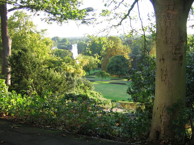

A view from Richmond Hill over the Terraced Gardens.
Parks take up a great deal of the borough and include Richmond Park, Bushy Park, Kew Gardens, and Hampton Court Park. There are over 100 parks and open spaces within its boundary and 21 miles (34 km) of river frontage. 140 hectares within the borough are designated as part of the Metropolitan Green Belt.
The borough is home to the National Physical Laboratory and the attractions of Hampton Court Palace, Twickenham Stadium and the WWT London Wetlands Centre that draw domestic and international tourism.
In December 2006, Sport England published a survey which revealed that residents of Richmond upon Thames were the second most active in England in sports and other fitness activities. 29.8% of the population participate at least three times a week for 30 minutes.[4]
The river Thames becomes narrower than at any part of Inner London towards its flow into the borough and becomes non-tidal at Teddington Lock in the borough; its main axis runs south to north, rather than west to east through more than half of the borough.[5]
History[]
The borough was formed in 1965 by the merger of the Municipal Borough of Twickenham from Middlesex with the Municipal Borough of Richmond and the Municipal Borough of Barnes from Surrey; council offices were centred at York House in Twickenham. The name "Richmond upon Thames" was coined at that time; it is now commonly but inaccurately used to refer to Richmond only.
Coat of arms[]
The borough's history is reflected in the coat of arms, which was officially granted on 7 May 1966. It is: Ermine a portcullis or within a bordure gules charged with eight fleurs-de-lis or. The crest is: On a wreath argent and gules out of a mural crown gules a swan rousant argent in beak a branch of climbing red roses leaved and entwined about the neck proper. The supporters are: On either side a griffin gules, armed and beaked azure, each supporting an oar proper, the blade of the dexter dark blue and that of the sinister light blue. The portcullis was taken from the arms of the Municipal Borough of Richmond; the swan crest, from the arms of the Municipal Borough of Twickenham; and the griffin supporters and oars from the arms of the Municipal Borough of Barnes. Red, gold and ermine are the royal livery colours, reflecting Richmond's royal history. The swan represents the River Thames, which flows through the borough. The oars are from the Oxford University Boat Club and the Cambridge University Boat Club, reflecting the fact that the Boat Race between the two universities ends at Mortlake in the borough.[6]
Politics[]
The borough currently has a Conservative-led council which has been the most common administration since its formation. The previous administration was led by the Liberal Democrats.
| Conservative | Lib Dem | Labour | Others | ||
| 2014 | Conservative | 39 | 15 | – | – |
| 2010 | Conservative | 30 | 24 | – | – |
| 2006 | Liberal Democrat | 19 | 35 | – | – |
| 2002 | Conservative | 39 | 15 | – | – |
| 1998 | Liberal Democrat | 14 | 34 | 4 | – |
| 1994 | Liberal Democrat | 7 | 43 | 2 | – |
| 1990 | Liberal Democrat | 4 | 48 | – | – |
| 1986 | Liberal/SDP Alliance | 3 | 49 | – | – |
| 1982 | Conservative (minority) | 26 | 26 | – | – |
| 1978 | Conservative | 34 | 18 | – | – |
| 1974 | Conservative | 36 | 10 | 8 | – |
| 1971 | Conservative | 37 | 3 | 14 | – |
| 1968 | Conservative | 54 | – | – | – |
| 1964 | Conservative | 41 | – | 12 | 1 |
Transport[]
Buses[]
The borough is served by the following London bus routes: 33, 65, 72, 110, 111, 190, 209, 216, 265, 267, 281, 283, 285, 290, 337, 371, 391, 411, 419, 430, 465, 481, 485, 490, 493, H22, H37, R68, R70, X26 and night routes N9 and N22.
Rail services[]
The borough is connected to central London by the National Rail services of South West Trains. The London Underground's District line serves Richmond and Kew Gardens stations: both are also served by London Overground trains on the North London Line.
The other stations are: Barnes; Barnes Bridge; Fulwell; Hampton; Hampton Wick; Mortlake; North Sheen; St Margarets; Strawberry Hill; Teddington; Twickenham and Whitton.
Travel to work[]
In March 2011, the main forms of transport that residents used to travel to work were: driving a car or van, 23.4% of all residents aged 16–74; train, 7.7%; underground, metro, light rail, tram, 7.7%; work mainly at or from home, 6.4%; on foot, 5.9%; bus, minibus or coach, 5.5%; bicycle, 4.4%.[7]
Education[]
Richmond upon Thames is the local education authority for the borough, and has responsibility for 52 schools.
Sport and leisure[]
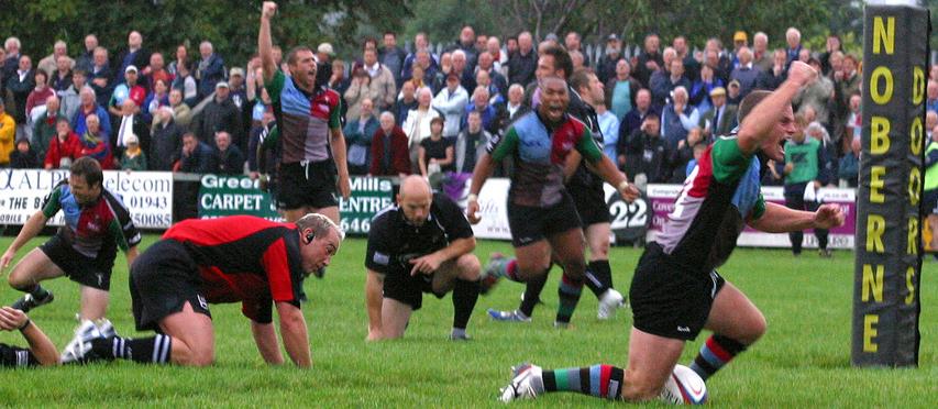

Harlequins during the 2005–2006 season


View from a helicopter of Ham House, the River Thames and Ham Polo Club
The borough has a Non-League football club Hampton & Richmond Borough F.C. who play at Beveree Stadium. The Twickenham Stadium hosts rugby internationals and the Twickenham Stoop is home to the Harlequins Rugby Team and London Broncos rugby league team.
Richmond Rugby Club are also active and share their grounds with London Scottish. The Richmond Minis is a large youth rugby organisation whilst the Richmond Heavies organise games for more veteran players.
Cricket is played in many locations around the borough including Ham Common, Richmond Green and Kew Green.
The River Thames flows through the borough and there are a number of sailing and rowing clubs located along it.
The borough has a large amount of equestrian activity; this includes the Horse Rangers Association and Ham Polo Club.
Richmond's swimming pools, Pools on the Park, are located on Twickenham Road close to the town centre. The outdoor pool is open in the summer months only.
Twin towns and sister cities[]
Richmond upon Thames is twinned with:
 Fontainebleau, France[8](since 1977)[9]
- Konstanz, Germany (since 1983)[9]
- Richmond, Virginia, United States (since 1980)[9]
See also[]
- List of people from Richmond upon Thames
References[]
- ^ Data Management and Analysis Group, Greater London Authority, Demography Update October 2007, (2007)
- ^ Womack, Sarah (12 August 2006). "Report on the quality of life around Britain". The Daily Telegraph. http://www.telegraph.co.uk/news/1526150/Welcome-to-Elmbridge-where-the-sun-shines-on-the-locals.htm. Retrieved 9 March 2014.
- ^ a b London's Poverty Profile Trust for London and New Policy Institute, 2010
- ^ "Active People Survey 1". Sport England. http://www.sportengland.org/research/active_people_survey/active_people_survey_1.aspx. Retrieved 22 November 2012.
- ^ Grid square map Ordnance survey website
- ^ "Richmond upon Thames". Heraldry of the World. http://www.ngw.nl/heraldrywiki/index.php?title=Richmond_upon_Thames. Retrieved 26 June 2014.
- ^ "2011 Census: QS701EW Method of travel to work, local authorities in England and Wales". Office for National Statistics. http://www.ons.gov.uk/ons/rel/census/2011-census/key-statistics-and-quick-statistics-for-wards-and-output-areas-in-england-and-wales/rft-qs701ew.xls. Retrieved 23 November 2013. Percentages are of all residents aged 16-74 including those not in employment. Respondents could only pick one mode, specified as the journey’s longest part by distance.
- ^ "British towns twinned with French towns". Archant Community Media Ltd. http://www.completefrance.com/language-culture/twin-towns. Retrieved 11 July 2013.
- ^ a b c "Twinning". Visit Richmond, London Borough of Richmond upon Thames. http://www.visitrichmond.co.uk/twinning.aspx. Retrieved 14 September 2013.
External links[]
- Richmond upon Thames Council
- Richmond & Twickenham Times online
- Richmond Online Communities website
- Totally Richmond website
- This is Our Town Richmond community website
- Visit Richmond
- Your Richmond
- Library Local History Notes on houses and persons mentioned
- Free Richmond Virtual Simulation
| ||||||||||||||||||||

| |||||||||||||||||
| This page uses content from the English language Wikipedia. The original content was at London Borough of Richmond upon Thames. The list of authors can be seen in the page history. As with this Familypedia wiki, the content of Wikipedia is available under the Creative Commons License. |