| Main | Births etc |
|---|
| Uley | |
Uley | |
| Population | 1,170 [1] |
|---|---|
| OS grid reference | |
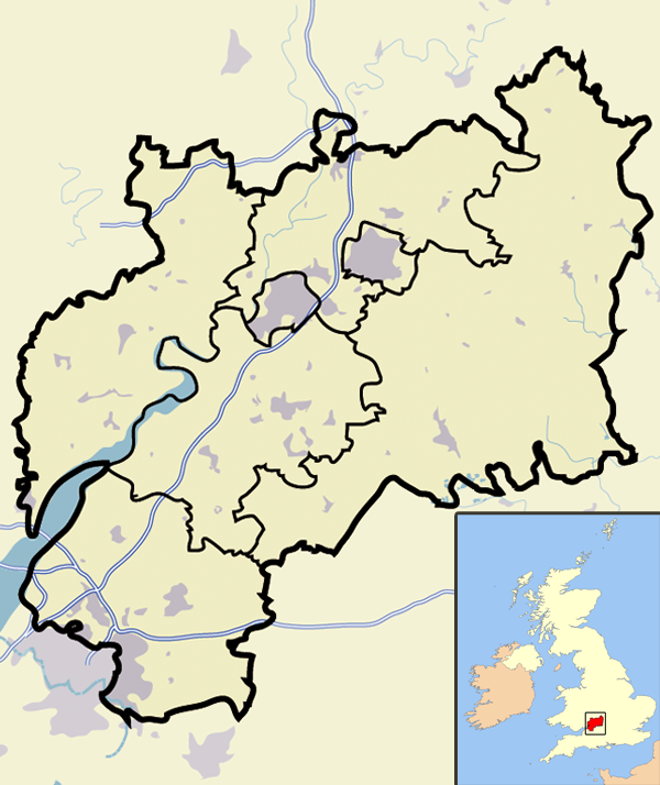
| District | Stroud |
| Shire county | Gloucestershire |
| Region | South West |
| Country | England |
| Sovereign state | United Kingdom |
| Post town | Dursley |
| Postcode district | GL11 |
| Police | Gloucestershire |
| Fire | Gloucestershire |
| Ambulance | Great Western |
| EU Parliament | South West England |
| UK Parliament | Stroud |
| List of places: UK • England • Gloucestershire | |
Uley /ˈjuːli/ is a village in the county of Gloucestershire, England.[2] It is situated in a wooded valley in the Cotswold escarpment, on the B4066 road between Dursley and Stroud. The population is around 1,100, but was much greater during the early years of the industrial revolution, when the village was renowned for producing blue cloth. The placename (recorded as Euuelege in the Domesday Book) probably signifies 'clearing in a yew wood'.
History[]


Uley, with Uley Bury rising behind it, as seen from Bencombe
The Romans built a temple at West Hill, near Uley, on the site of an earlier prehistoric shrine. Following the laying of a water main pipe there in 1976, many discoveries were made including numerous Roman writing tablets[3] or lead curse tablet from the temple area. These writing tablets appear often to relate to theft, and here the mention of animals and farm implements is a regular theme. There is an ongoing, online project to catalogue all those found at West Hill.[4] Other remains from this temple, including a fine stone head of Mercury, can now be seen in the British Museum. There were significant Roman villas nearby at Frocester, Kingscote, and Woodchester, and there is a little-known Roman villa beneath Cam Peak on the road into Dursley.
St Giles's Church near the village green was designed by the 19th-century architect Samuel Sanders Teulon. His building replaced an earlier church dating back to Norman times, which had in its turn replaced a Saxon church. The nearby church of the Holy Cross at Owlpen also has Saxon origins: the church there was rebuilt in 1828 by Samuel Manning and enlarged and decorated in 1876 by James Piers St Aubyn. There were also non-conformist chapels at South St and Whitecourt until the early 1970s.
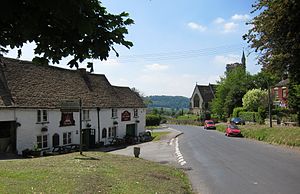
The village was once famous for its large number of pubs (around 14), lately reduced to a single hostelry (The Old Crown). Until the 1970s there was also a butcher's shop and a petrol station, these were subsequently replaced by antique shops and occasional restaurants, and now only a small village shop remains.

.jpg)
St Giles' church and the Old Crown pub, from the village green
The area surrounding Whitecourt appears to have some considerable historical significance, with long associations to the Osborne family and a possible Roman road transecting from Kingscote to the East via Bencombe, crossing the Ewelme brook close to the previous mill buildings opposite Stouts hill and then transiting what is now Lampern View before exiting W towards Cam/Coaley; elements clearly visible just uphill of Bencombe (as the road veers 90 degrees to the north) and to the West opposite the entrance to Angeston Grainge/Nursery (where it enters the wood as a paved and walled causeway.
The increased mechanisation of agriculture in the area (arable on top of the escarpment, sheep on it and cattle in the valleys) led to a gradual decline during the inter-war periods and this led to the construction of three local authority housing estates - South Sreet, Lampern View and Raglan Way. However, increased mobility following the construction of the M4 and the Severn Bridge in the mid-1960s, together with an influx of skilled/managerial/professional workers following the establishment of such facilities as the Berkeley power station, led to a steady gentrification of the village, witnessed by the construction of substantial detached homes, for example at Court Gardens, South Sreet and Green Close.
Economy[]
Uley Brewery was established in the 1980s, in a Grade II listed building that had been part of the 1833 Price Brewery which closed at the end of the 19th century. The brewery was purchased and refitted by current owner Chas Wright, complete with custom-made brewing vessels.[5] The brewery is situated above a natural spring, and uses Maris Otter barley malt (sourced from Tuckers Maltings, Newton Abbot), Fuggles and Goldings hops, and a traditional method of top fermentation.[6] Its range of ales includes Old Spot Prize Ale, a 5% abv old ale, and Uley Bitter, a 4% abv cask bitter.[7]
Amenities and surrounding locality[]
The following amenities and attractions are available in and around the village:
- North of the village is a Neolithic burial mound known as Hetty Pegler's Tump[8] or Uley Long Barrow.
- Uley's only remaining pub, the Old Crown,[9] is situated on the village green, opposite the church.
- The Prema Arts Centre,[10] founded in the 1970s, is located in a former Baptist Chapel in the village and offers educational courses in the arts and crafts, musical evenings, workshops, cultural events and evening classes in many subjects.
- Uley CofE VC primary school has around 100 pupils. Uley Primary School[11] can be found in Woodstock Terrace.
- A Reading Room (Library) burned down in the mid-1960s and has not been replaced.
- An ancient Iron Age hill fort called Uley Bury[12] lies just above the village. The Cotswold Way,[13] a popular trail path, runs close by.
- Downham Hill lies just to the west: it is known locally as 'Smallpox Hill' because of the smallpox isolation facility that stood on the top of the hill many years ago (masonry still visible).
- To the east is Owlpen Manor,[14] a Tudor manor house connected with the arts and crafts movement, mainly built from the mid-fifteenth to early seventeenth centuries, but dating back to Saxon times. It was repaired by Norman Jewson in 1925–6, after one hundred years of neglect. Today it is a home of the Mander family.
- Stouts Hill,[15] a neo-Gothic country house just outside the village, was the birthplace of the Gloucestershire historian, Samuel Rudder, and of the distinguished Persian scholar Edward Granville Browne. Built for the Gyde family, from the 1770s it was a seat of the Lloyd-Baker family, who in the 20th century let the house as a preparatory school. It included amongst its alumni Mark Phillips, Stephen Fry and Rik Mayall, but closed down in 1979.
People[]
- Brigadier Mike Dauncey lives in the village.
Trivia[]
- In 1837, Moses Bendle Garlick, a weaver from Uley, migrated to Australia and settled just north of what is currently Adelaide; he named the settlement Uleybury.
- During the 1920s, Miss Edna Cunningham, brought a baby gorilla to Uley. John Daniel, as the gorilla was known, lived and was raised as a normal child by Miss Cunningham. When John Daniel grew too large, he was sent to the USA. Without the company of Miss Cunningham, John Daniel fell sick and died. Upon his death he was stuffed and can still be seen today in the Natural History Museum, New York.[16]
- A very brief shot of Uley is featured in episode 6 of series 3 of the Channel 4 comedy Peep Show. This is despite the fact the episode is set in the Quantocks which are, in fact, a considerable distance from the village.
References[]
- ^ "Uley Parish Population". Neighbourhood Statistics. National Census 2001. http://www.neighbourhood.statistics.gov.uk/dissemination/LeadTableView.do?a=7&b=794925&c=GL11+5TH&d=16&e=15&g=448737&i=1001x1003x1004&m=0&r=0&s=1248519789418&enc=1&dsFamilyId=779. Retrieved 2009-07-25.
- ^ Uley village website
- ^ Roman writing tablets in Uley
- ^ West Hill Project
- ^ "Uley Brewery website". http://www.uleybrewery.com/index.htm. Retrieved 2009-05-09.
- ^ Uley Brewery
- ^ "Uley". ratebeer.com. http://ratebeer.com/brewers//uley/3945/. Retrieved 2009-07-13.
- ^ Hetty Pegler's Tump
- ^ Old Crown website
- ^ Prema Arts Centre
- ^ Uley Primary School website
- ^ Uley Bury
- ^ Cotswold Way
- ^ Owlpen Manor
- ^ Stouts Hill website
- ^ John Daniel info
Bibliography[]
- Ann Woodward and Peter Leach, The Uley Shrines: Excavation of a ritual complex on West Hill, Uley 1977-79 (1993), English Heritage, ISBN 1-85074-303-7
- Alan Saville, Uley Bury and Norbury Hillforts (1983), Western Archaeological Trust, ISBN 0-904918-20-3
- Ed. Alan Bebbington, A History of Uley, Gloucestershire (2003), The Uley Society, ISBN 0-9544525-0-X
- Eilart Ekwall, The Concise Oxford Dictionary of English Place-names 4th edition. Oxford University Press, 1960, ISBN 0-19-869103-3
External links[]
| This page uses content from the English language Wikipedia. The original content was at Uley. The list of authors can be seen in the page history. As with this Familypedia wiki, the content of Wikipedia is available under the Creative Commons License. |