| Main | Births etc |
|---|
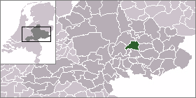
| Steenderen | |||
|---|---|---|---|
|
|||
| Coordinates: | |||
| Country | Netherlands | ||
| Province | Gelderland | ||
| Municipality | Bronckhorst | ||


|
| |
| Country | Netherlands |
| Province | Gelderland |
| Area - Land - Water |
50.23 km² 48.73 km² 1.50 km² |
| Population (2004) - Density |
5,087 104/km² |
Steenderen is a former municipality and a town in the eastern Netherlands.
Population centres[]
- Baak
- Bronkhorst
- Olburgen
- Rha
- Steenderen
- Toldijk
Gallery[]
")
Steenderen, view to the village with two church towers
")
Steenderen, church (de Sint Remigiuskerk) in the street
")
Steenderen, church: de Sint Willibrorduskerk
")
between Steenderen and Bronkhorst, Bronkhorstermolen windmill
External links[]
| This Gelderland location article is a stub. You can help by expanding it. |
| This page uses content from the English language Wikipedia. The original content was at Steenderen. The list of authors can be seen in the page history. As with this Familypedia wiki, the content of Wikipedia is available under the Creative Commons License. |