| Main | Births etc |
|---|
| St. John's | |||
|---|---|---|---|
| — City — | |||
| City of St. John's | |||
 |
|||
|
|||
| Nickname(s): "The City of Legends" | |||
| Motto: Avancez (English: "Go forward") | |||
|
|||
| Coordinates: | |||
| Country | |||
| Province | |||
| Census division | 1 | ||
| Founded | 24 June 1497 | ||
| Established | 5 August 1583 by Royal Charter of Queen Elizabeth I | ||
| Government | |||
| • Type | City Council | ||
| • Mayor | Dennis O'Keefe | ||
| • Governing body | St. John's City Council | ||
| • MPs | List of MPs
|
||
| • MHAs | List of MHAs
|
||
| Area | |||
| • City | 446.04 km2 (172.2 sq mi) | ||
| • Urban | 182.62 km2 (70.51 sq mi) | ||
| • Metro | 804.63 km2 (310.7 sq mi) | ||
| Elevation | Sea Level 0–147 m (0–483 ft) | ||
| Population (2011 census[1]) | |||
| • City | 106,172 | ||
| • Density | 238.0/km2 (91.9/sq mi) | ||
| • Urban | 165,346 | ||
| • Urban density | 891.1/km2 (2,308/sq mi) | ||
| • Metro | 196,966 | ||
| • Metro density | 244.8/km2 (94.9/sq mi) | ||
| • Demonym | Townie | ||
| 20th Largest metropolitan area in Canada | |||
| Time zone | NST (UTC-3:30) | ||
| • Summer (DST) | NDT (UTC-2:30) | ||
| Area code(s) | 709 | ||
| Dwellings | 45,317[1] | ||
| Median Income | $75,930 CDN[2] | ||
| Website | St. John's website | ||
Coordinates: St. John's ( /ˌseɪntˈdʒɒnz/, local /ˌseɪntˈdʒänz/) is the capital and largest city in Newfoundland and Labrador, and is considered by some to be the oldest English-founded city in North America.[3] It is located on the eastern tip of the Avalon Peninsula on the island of Newfoundland.[4] With a population of 200,600 as of 2012, the St. John's Metropolitan Area is the second largest Census Metropolitan Area (CMA) in Atlantic Canada after Halifax and the 20th largest metropolitan area in Canada.[5] Its name has been attributed to the feast day of John the Baptist, when John Cabot was believed to have sailed into the harbour in 1497, and also to a Basque fishing town with the same name.[6][7]
Newfoundland was claimed as an English colony in the name of Elizabeth I in 1583, temporarily captured by the Dutch in 1665, and attacked three times by the French who captured and destroyed its settlements in 1689 and 1707. St John's was retaken each time and re-fortified. British forces used St. John's fortifications during the Seven Years' War in North America, the American Revolutionary War and the War of 1812. St. John's served Allied needs in World War ll by providing an air base for the USAAF and a harbour for antisubmarine warfare ships.
St. John's, and the province as a whole, was gravely affected in the 1990s by the collapse of the Northern cod fishery, which had been the driving force of the provincial economy for hundreds of years.[8] After a decade of high unemployment rates and depopulation, the city's proximity to the Hibernia, Terra Nova and White Rose oil fields has led to an economic boom that has spurred population growth and commercial development. As a result, the St. John's area now accounts for about half of the province's economic output.[9][10]
History[]
Considered by some to be "North America's Oldest City", St. John's is one of the oldest settlements in North America, with year-round settlement beginning sometime after 1630 and seasonal habitation long before that.[3] It is not, however, the oldest surviving English settlement in North America or Canada, having been preceded by the Cuper's Cove colony at Cupids, founded in 1610, and the Bristol's Hope colony at Harbour Grace, founded in 1618.[11] In fact, although English fisherman had begun setting up seasonal camps in Newfoundland in the 16th Century, they were expressly forbidden by the British government, at the urging of the West Country fishing industry, from establishing permanent settlements along the English controlled coast, hence the town of St. John's was not established as a permanent community until after the 1630s at the earliest.[12] Other permanent English settlements in the Americas that predate St. John's include: St. George's, Bermuda (1612)[13] and Jamestown, Virginia (1607).[14]
Sebastian Cabot declares in a hand written text in Latin in his original 1544 map,[15] that the St. John's earned its name when he and his father, the Venetian explorer John Cabot became the first Europeans to sail into the harbour, in the morning of June 24, 1494 (against British and French historians stating 1497),[16] the feast day of Saint John the Baptist.[6] However, the exact locations of Cabot's landfalls are disputed.[17][18] A series of expeditions to St. John's by Portuguese from the Azores took place in the early 16th century, and by 1540 French, Spanish and Portuguese ships crossed the Atlantic annually to fish the waters off the Avalon Peninsula. In the Basque Country, it is a common belief that the name of St. John's was given by Basque fishermen because the bay of St. John's is very similar to the Bay of Pasaia in the Basque Country, where one of the fishing towns is also called St. John (in Spanish, San Juan).[7]


Plaque commemorating Gilbert's founding of the British Empire
The earliest record of the location appears as São João on a Portuguese map by Pedro Reinel in 1519. When John Rut visited St. John's in 1527 he found Norman, Breton and Portuguese ships in the harbour. On August 3, 1527, Rut wrote a letter to King Henry on the findings of his voyage to North America; this was the first known letter sent from North America. St. Jehan is shown on Nicholas Desliens' world map of 1541 and San Joham is found in João Freire's Atlas of 1546.[19] It was during this time that Water Street was first developed, making it the oldest street in North America.
On August 5, 1583, Sir Humphrey Gilbert claimed the area as England's first overseas colony under Royal Charter of Queen Elizabeth I.[20] There was no permanent population, however, and Gilbert was lost at sea during his return voyage, thereby ending any immediate plans for settlement.[7] The Newfoundland National War Memorial is located on the waterfront in St. John's, at the purported site of Gilbert's landing and proclamation.
By 1620, the fishermen of England's West Country controlled most of Newfoundland's east coast.[21] In 1627, William Payne, called St. John's "the principal prime and chief lot in all the whole country". The population grew slowly in the 17th century and St. John's was the largest settlement in Newfoundland when English naval officers began to take censuses around 1675.[19] The population would grow in the summers with the arrival of migratory fishermen.[7] In 1680, fishing ships (mostly from South Devon) set up fishing rooms at St. John's, bringing hundreds of Irish men into the port to operate inshore fishing boats.[19]
The town's first significant defences were likely erected due to commercial interests, following the temporary seizure of St. John's by the Dutch admiral Michiel de Ruyter in June 1665. The inhabitants were able to fend off a second Dutch attack in 1673, when this time it was defended by Christopher Martin, an English merchant captain. Martin landed six cannon from his vessel, the Elias Andrews, and constructed an earthen breastwork and battery near chain Rock commanding the Narrows leading into the harbour. With only twenty-three men, the valiant Martin beat off an attack by three Dutch warships. The English government planned to expand these fortifications (Fort William) in around 1689, but actual construction didn't begin until after the French admiral Pierre Le Moyne d'Iberville captured and destroyed the town in the Avalon Peninsula Campaign (1696). When 1500 English reinforcements arrived in late 1697 they found nothing but rubble where the town and fortifications had stood. The French attacked St. John's again in 1705 (Siege of St. John's), and captured it in 1708 (Battle of St. John's), devastating civilian structures with fire on each instance.[19]


Water Street, St. John's
The harbour remained fortified through most of the 18th and 19th centuries.[7] The final battle of the Seven Years' War in North America (the French and Indian War) was fought in 1762, in St. John's.[7] Following a surprise capture of the town by the French early in the year, the British responded, and at the Battle of Signal Hill, the French surrendered St. John's to British forces under the command of Colonel William Amherst.[19][22]
The 18th century saw major changes in Newfoundland: population growth, beginnings of government, establishment of churches, reinforcement of commercial ties with North America and development of the seal, salmon and Grand Banks fisheries. St. John's population grew slowly, and although it was still primarily a fishing station, it was also a garrison, a centre of government and a commercial hub. St. John's served as a naval base during both the American Revolutionary War and the War of 1812.[19]
The core of the city was destroyed by fire several times, the most famous of which was the Great Fire of 1892.[23]
Guglielmo Marconi received the first transatlantic wireless signal in St. John's on December 1901 from his wireless station in Poldhu, Cornwall.[24]


U.S. Army troops on guard in St. John's in 1942
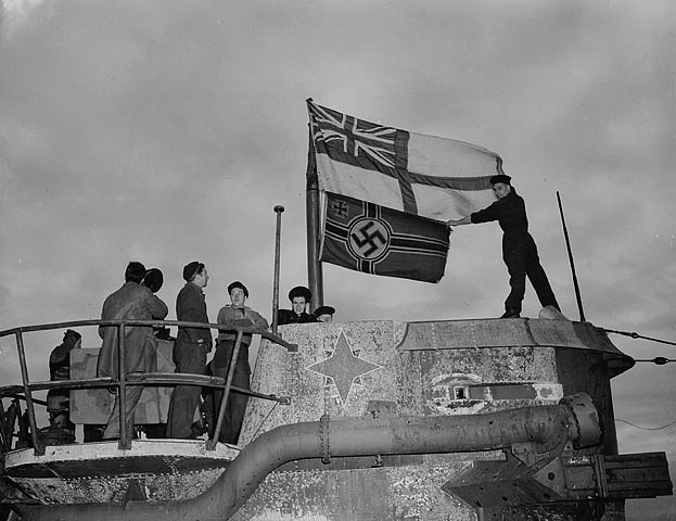

Seamen raise White Ensign over a captured German U-boat in St. John's, Newfoundland in 1945
St. John's was the starting point for the first non-stop transatlantic aircraft flight, by Alcock and Brown in a modified Vickers Vimy IV bomber, in June 1919, departing from Lester's Field in St. John's and ending in a bog near Clifden, Connemara, Ireland.[25] In July 2005, the flight was duplicated by American aviator and adventurer Steve Fossett in a replica Vickers Vimy aircraft, with St. John's International Airport substituting for Lester's Field (now an urban and residential part of the city).[26]
During the Second World War, the harbour supported Royal Navy and Royal Canadian Navy ships that were engaged in anti-submarine warfare. It was also the site of an American Army Air Force base, Fort Pepperrell, that was established as part of the "Lend-Lease" agreement between the United Kingdom and United States.[7] The base was transferred to Canadian control in 1960 and is now known as CFS St. John's. The Knights of Columbus Hostel fire in December 1942, saw 99 military and civilian lives lost.[27]
As of 2012, St. John's contains 21 National Historic Sites of Canada.[28][29]
St. John's is serviced by one major airport, and has daily direct service to Toronto, Ottawa, Montreal, Gander, Deer Lake, Wabush, Goose Bay and Halifax; and seasonal service direct to Calgary and London.
Geography[]
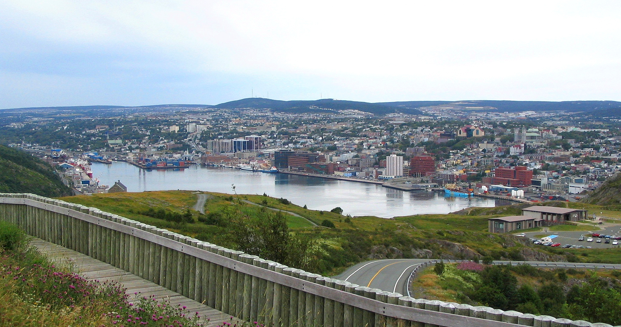
St. John's is located along the coast of the Atlantic Ocean, on the northeast of the Avalon Peninsula in southeast Newfoundland.[4] The city covers an area of 446.04 square kilometres (172.22 sq mi) and is the most easterly city in North America, excluding Greenland;[30] it is 295 miles (475 km) closer to London, United Kingdom than it is to Edmonton, Alberta.[31] The city is the largest in the province and the second largest in the Atlantic Provinces after Halifax, Nova Scotia.[32] Its downtown area lies to the west and north of St. John's Harbour, and the rest of the city expands from the downtown to the north, south, east and west.
Coniferous trees such as black spruce, white spruce, and balsam fir dominate the native vegetation. The largest deciduous tree is white birch; species of lesser stature include alder, cherry and mountain ash. Of introduced tree species, sycamore maple is most abundant and Norway maple is common. Blue spruce, common horsechestnut, European beech and littleleaf linden are among the other non-native species grown.[33]
Climate[]
St. John's has a humid continental climate (Köppen Dfb) with cool-to-warm summers, and relatively mild winters, which is due to Gulf Stream moderation. Mean temperatures range from −5.4 °C (22.3 °F) in February to 15.5 °C (59.9 °F) in August, showing somewhat of a seasonal lag in the climate. The city is also one of the areas of the country most prone to tropical cyclone activity, as it is bordered by the Atlantic Ocean to the east, where tropical storms (and sometimes hurricanes) travel from this country.
Of major Canadian cities, St. John's is the foggiest (124 days),[34] windiest (24.3 km/h (15.1 mph) average speed),[35] and cloudiest (1,497 hours of sunshine).[36] St. John's experiences milder temperatures during the winter season in comparison to other Canadian cities and has the mildest winter for a city outside of British Columbia.[37]
| Climate data for St. John's (St. John's Airport, normals from 1981−2010) | |||||||||||||
|---|---|---|---|---|---|---|---|---|---|---|---|---|---|
| Month | Jan | Feb | Mar | Apr | May | Jun | Jul | Aug | Sep | Oct | Nov | Dec | Year |
| Humidex | 19.2 | 17.3 | 17.2 | 26.1 | 29.5 | 34.8 | 38.5 | 37.7 | 35.8 | 29.8 | 23.7 | 20.7 | 38.5 |
| Record high °C (°F) | 15.7 (60.3) |
16.0 (60.8) |
18.3 (64.9) |
24.1 (75.4) |
25.6 (78.1) |
29.4 (84.9) |
31.5 (88.7) |
31.0 (87.8) |
29.5 (85.1) |
24.6 (76.3) |
19.4 (66.9) |
17.3 (63.1) |
31.5 (88.7) |
| Average high °C (°F) | −0.8 (30.6) |
−1.1 (30.0) |
1.0 (33.8) |
5.6 (42.1) |
11.1 (52.0) |
15.8 (60.4) |
20.7 (69.3) |
20.5 (68.9) |
16.5 (61.7) |
10.8 (51.4) |
6.4 (43.5) |
1.8 (35.2) |
9.0 (48.2) |
| Daily mean °C (°F) | −4.5 (23.9) |
−4.9 (23.2) |
−2.6 (27.3) |
1.9 (35.4) |
6.4 (43.5) |
10.9 (51.6) |
15.8 (60.4) |
16.1 (61.0) |
12.4 (54.3) |
7.4 (45.3) |
3.0 (37.4) |
−1.5 (29.3) |
5.0 (41.0) |
| Average low °C (°F) | −8.2 (17.2) |
−8.6 (16.5) |
−6.1 (21.0) |
−1.9 (28.6) |
1.7 (35.1) |
5.9 (42.6) |
10.9 (51.6) |
11.6 (52.9) |
8.2 (46.8) |
3.9 (39.0) |
−0.3 (31.5) |
−4.7 (23.5) |
1.0 (33.8) |
| Record low °C (°F) | −23.3 (−9.9) |
−23.8 (−10.8) |
−23.8 (−10.8) |
−14.8 (5.4) |
−6.7 (19.9) |
−3.3 (26.1) |
−1.1 (30.0) |
0.5 (32.9) |
−1.1 (30.0) |
−5.6 (21.9) |
−13.4 (7.9) |
−19.7 (−3.5) |
−23.8 (−10.8) |
| Wind chill | −35.7 | −40.3 | −40.3 | −21.4 | −14.2 | −7.7 | −3.4 | 0.0 | −4.4 | −11.8 | −24.6 | −34.3 | −40.3 |
| Precipitation mm (inches) | 149.2 (5.874) |
129.5 (5.098) |
142.2 (5.598) |
122.9 (4.839) |
102.6 (4.039) |
97.6 (3.843) |
91.6 (3.606) |
100.0 (3.937) |
129.6 (5.102) |
156.2 (6.15) |
148.1 (5.831) |
164.8 (6.488) |
1,534.2 (60.402) |
| Rainfall mm (inches) | 66.0 (2.598) |
61.6 (2.425) |
84.8 (3.339) |
96.1 (3.783) |
97.9 (3.854) |
97.5 (3.839) |
91.6 (3.606) |
100.0 (3.937) |
129.6 (5.102) |
153.7 (6.051) |
124.8 (4.913) |
102.9 (4.051) |
1,206.4 (47.496) |
| Snowfall cm (inches) | 88.7 (34.92) |
71.0 (27.95) |
57.3 (22.56) |
25.3 (9.96) |
4.4 (1.73) |
0.04 (0.016) |
0.0 (0) |
0.0 (0) |
0.0 (0) |
2.4 (0.94) |
22.4 (8.82) |
63.4 (24.96) |
335.0 (131.89) |
| Avg. precipitation days (≥ 0.2 mm) | 21.8 | 18.5 | 19.6 | 17.3 | 16.6 | 14.7 | 13.6 | 13.7 | 15.5 | 18.6 | 19.7 | 22.0 | 211.7 |
| Avg. rainy days (≥ 0.2 mm) | 9.3 | 8.6 | 11.0 | 13.9 | 15.9 | 14.7 | 13.6 | 13.7 | 15.5 | 18.1 | 15.7 | 12.7 | 162.6 |
| Avg. snowy days (≥ 0.2 cm) | 18.3 | 14.6 | 13.3 | 7.0 | 2.1 | 0.07 | 0.0 | 0.0 | 0.0 | 1.4 | 7.6 | 14.6 | 78.9 |
| Mean monthly sunshine hours | 65.5 | 90.2 | 107.4 | 140.4 | 176.3 | 198.9 | 216.7 | 206.6 | 170.5 | 122.1 | 76.3 | 62.4 | 1,633.2 |
| Percent possible sunshine | 23.7 | 31.1 | 29.2 | 34.3 | 37.6 | 41.7 | 44.9 | 46.7 | 45.1 | 36.2 | 27.2 | 23.7 | 35.1 |
| Source: Environment Canada[38] | |||||||||||||
Cityscape[]
Template:Portal:Canadian/Selected panoramic picture/Layout
Architecture[]
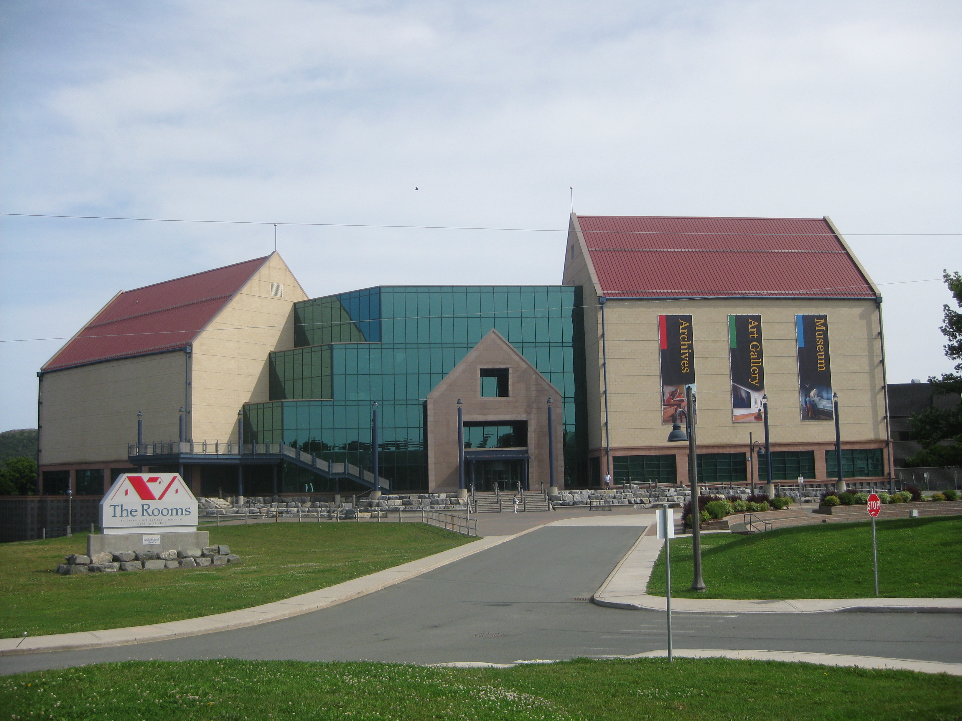

The Rooms
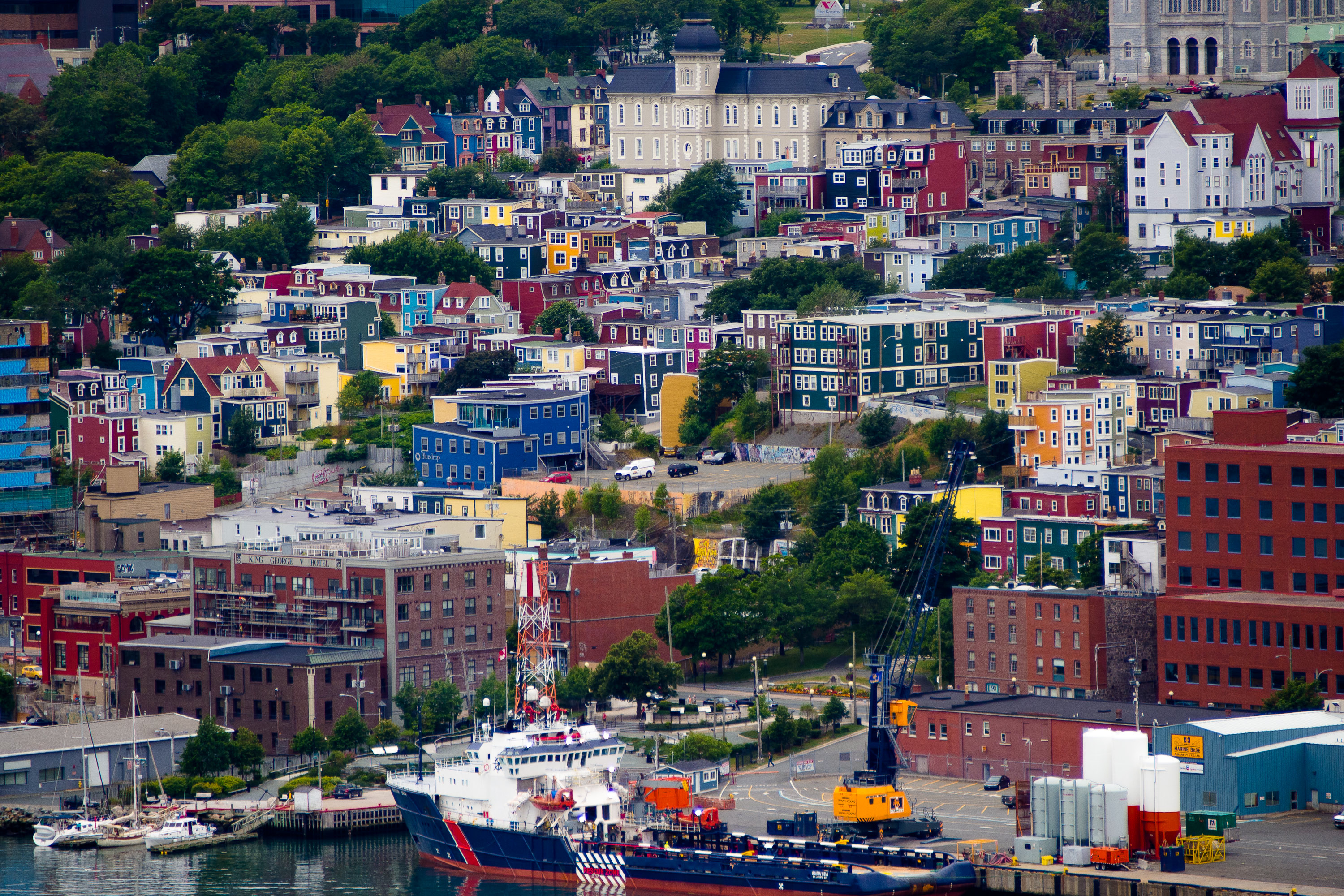

.jpg)
Looking at St. John's Jelly Bean Row and waterfront from Signal Hill; the colourful row houses, August 2012
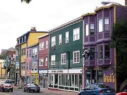
The architecture of St. John's has a distinct style from that of the rest of Canada, and its major buildings are remnants of its history as one of the first British colonial capitals. Buildings took a variety of styles according to the means available to build the structures.
Starting as a fishing outpost for European fishermen, St. John's consisted mostly of the homes of fishermen, sheds, storage shacks, and wharves constructed out of wood. Like many other cities of the time, as the Industrial Revolution took hold and new methods and materials for construction were introduced, the landscape changed as the city grew in width and height. The Great Fire of 1892 destroyed most of the downtown core, and most residential and other wood-frame buildings date from this period.[23]
Often compared to San Francisco due to the hilly terrain and steep maze of residential streets, housing in St. John's is typically painted in bright colours.[39] The city council has implemented strict heritage regulations in the downtown area, including restrictions on the height of buildings.[40] These regulations have caused much controversy over the years. With the city experiencing an economic boom a lack of hotel rooms and office space has seen proposals put forward that do not meet the current height regulations. Heritage advocates argue that the current regulations should be enforced while others believe the regulations should be relaxed to encourage economic development.[41][42][43][44]
To meet the need for more office space downtown without compromising the city's heritage, the city council amended heritage regulations, which originally restricted height to 15 metres in the area of land on Water Street between Bishop's Cove and Steer's Cove, to create the "Commercial Central Retail - West Zone". The new zone will allow for buildings of greater height. A 47-metre, 12-storey office building, which includes retail space and a parking garage, was the first building to be approved in this area.[45]

Downtown St. John's
| Rank | Name | Floors | Completed |
|---|---|---|---|
| 1 | Confederation Building | 11 | 1959 |
| 2 | John Cabot Place | 13 | 1993 |
| 3 | St. Patrick's Church | N/A | 1914 |
| 4 | Cabot Place | 12 | 1987 |
| 5 | Delta Hotel | 13 | 1988 |
| 6 | Scotia Centre | 11 | 1987 |
| 7 | Southcott Hall | 13 | 1964 |
| 8 | Fortis Building | 12 | 1969 |
| 9 | TD Place | 10 | 1981 |
| 10 | Atlantic Place | 9 | 1975 |
| 10 | Tiffany Village | 9 | 2009 |
Demographics[]
As of the 2006 Census, there were 100,646 inhabitants in St. John's itself, 151,322 in the urban area and 181,113 in the St. John's Census Metropolitan Area (CMA).[47] Thus, St. John's is Newfoundland and Labrador's largest city and Canada's 20th largest CMA.[48] Apart from St. John's, the CMA includes 12 other communities: the city of Mount Pearl and the towns of Conception Bay South, Paradise, Portugal Cove-St. Philip's, Torbay, Logy Bay-Middle Cove-Outer Cove, Pouch Cove, Flatrock, Bay Bulls, Witless Bay, Petty Harbour-Maddox Cove and Bauline.[47] The population of the CMA was 192,326 as of July 1, 2010.[49]
| Historical populations[50] | ||
|---|---|---|
| Year | Pop. | ±% |
| 1986 | 103,079 | — |
| 1991 | 104,659 | +1.5% |
| 1996 | 101,936 | −2.6% |
| 2001 | 99,182 | −2.7% |
| 2006 | 100,646 | +1.5% |
| 2011 | 106,172 | +5.5% |
| Ethnic Origin, 2006[51] | |
|---|---|
| Ethnic Origin | Percentage |
| English | 45.5 |
| Canadian | 41.1 |
| Irish | 31.3 |
| Scottish | 8.3 |
| French | 4.6 |
| German | 2.1 |
| Mother tongue language, 2006[52] | ||
|---|---|---|
| Language | Population | Percentage |
| English only | 95,555 | 96.10% |
| Other languages | 3,420 | 3.43% |
| French only | 355 | 0.35% |
| Both English and French | 95 | 0.09% |
Religion[]
The information below is from the 2001 Canadian Census.[53]
Predominantly Christian, the population of St. John's was once divided along sectarian (Catholic/Protestant) lines. In recent years, this sectarianism has declined significantly, and is no longer a commonly acknowledged facet of life in St. John's. St. John's is the seat of the Roman Catholic Archbishop of St. John's, and the Anglican Bishop of Eastern Newfoundland and Labrador.
| Religion | 2001 | % |
|---|---|---|
| Roman Catholic | 83,615 | 48.9% |
| Anglican | 39,020 | 22.8% |
| United Church | 25,670 | 15.0% |
| Salvation Army | 5,645 | 3.3% |
| Pentecostal | 3,865 | 2.3% |
| No religion | 6,990 | 3.9% |
Economy[]


View of St. John's from The Rooms
The St. John's economy is connected to both its role as the provincial capital of Newfoundland and Labrador and to the ocean. The civil service which is supported by the federal, provincial and municipal governments has been the key to the expansion of the city's labour force and to the stability of its economy, which supports a sizable retail, service and business sector.[54] The provincial government is the largest employer in the city, followed by Memorial University.[55][56] With the collapse of the fishing industry in Newfoundland and Labrador in the 1990s the role of the ocean is now tied to what lies beneath it – oil and gas – as opposed to what swims in or travels across it.[57] The city is the centre of the oil and gas industry in Eastern Canada and is one of 19 World Energy Cities.[58] ExxonMobil Canada is headquartered in St. John's and companies such as Chevron, Husky Energy, Suncor Energy and Statoil have major regional operations in the city.[59][60] Three major offshore oil developments, Hibernia, Terra Nova and White Rose, are in production off the coast of the city and a fourth development, Hebron, is expected to be producing oil by 2017.[61][62]
The economy has been growing quickly in recent years. In both 2010 and 2011, the metro area's gross domestic product (GDP) led 27 other metropolitan areas in the country, according to the Conference Board of Canada, recording growth of 6.6 per cent and 5.8 per cent respectively.[63] At $52,000 the city's per capita GDP is the second highest out of all major Canadian cities.[64] Economic forecasts suggest that the city will continue its strong economic growth in the coming years not only in the "oceanic" industries mentioned above, but also in tourism and new home construction as the population continues to grow. In May 2011, the city's unemployment rate fell to 5.6 per cent, the second lowest unemployment rate for a major city in Canada.[65]
St. John's is also becoming known as an entrepreneurial city. In a 2009 report by the Canadian Federation of Independent Business; Communities in Boom: Canada’s Top Entrepreneurial Cities, St. John's was ranked the best major city in Atlantic Canada, and 19th overall in Canada for providing a good environment for small business development.[66]
Arts and culture[]

Duckworth Street
The downtown area is the cultural hub of St. John's and is a major tourist destination in Newfoundland and Labrador and Atlantic Canada. Water Street and Duckworth Street are known for their brightly coloured low rise heritage buildings housing numerous tourist shops, clothing boutiques, and restaurants.
George Street, a downtown side-street above the western end of Water Street, is the predominant home of the city's nightlife. The street holds numerous annual festivals including the George Street Festival in August and the Mardi Gras Festival held in October. The street can be credited with kick starting the careers of many musical acts and is busy nearly every night of the week.[67][68] St. Johns also plays host to the Tuckamore Festival of chamber music, which has been held every August since 2001.
The LSPU Hall is home to the Resource Centre for the Arts. The "Hall" hosts a vibrant and diverse arts community and is regarded as the backbone of artistic infrastructure and development in the downtown.[69] The careers of many well-known Newfoundland artists were launched there including Rick Mercer, Mary Walsh, Cathy Jones, Andy Jones and Greg Thomey. The St. John's Arts and Culture Centre houses an art gallery, libraries and a 1000 seat theatre, which is the city's major venue for entertainment productions.[70]
The Nickel Film Festival and the St. John's International Women's Film Festival are two independent film festivals held annually in St. John's.[71]
Attractions[]
Museums[]
The Provincial Museum of Newfoundland and Labrador (c. 1892-3) was located on Duckworth Street in a building listed on the Canadian Register of Historic Places.[72] In 2005 the museum, along with the Art Gallery of Newfoundland and Labrador and the Provincial Archives of Newfoundland and Labrador, moved into The Rooms. The Rooms is Newfoundland and Labrador's cultural facility, and is located in the downtown area.[73]
The Railway Coastal Museum is a transportation museum located in the 104-year-old Newfoundland and Labrador train station building on Water Street.[74]
The Johnson Geo Centre is a geological interpretation centre located on Signal Hill.[75] The centre is designed to teach the public about the history of the earth through the unique and complex geological history of Newfoundland and Labrador.
The East Rider Motorcycle Museum showcases over 110 years of Newfoundland's Motorcycle History, with two floors of bikes, memorabilia, and biker culture. Located downtown St. John's (above East Rider Motorcycle Gear Shop).
Urban parks[]
Pippy Park is an urban park located in the east end of the city; with over 3,400 acres (13.8 km2) of land, it is one of Canada‘s largest urban parks. The park contains a range of recreational facilities including two golf courses, Newfoundland and Labrador's largest serviced campground, walking and skiing trails as well as protected habitat for many plants and animals. Pippy Park is also home to the Fluvarium, an environmental education centre which offers a cross section view of Nagle's Hill Brook.[76]
Bowring Park, located in the Waterford Valley, is one of the most scenic parks in St. John's. Entrance to the park is via Waterford Bridge Road, passing a sculptured duck pond and a statue of Peter Pan. The park land was donated to the city in 1911 by Sir Edgar Rennie Bowring on behalf of Bowring Brothers Ltd. on their 100th anniversary of commerce in Newfoundland. The park was officially opened by His Royal Highness, the Duke of Connaught on July 15, 1914.[77]
Bannerman Park is a Victorian-style park located near the downtown. The park was officially opened in 1891 by Sir Alexander Bannerman, Governor of the Colony of Newfoundland who donated the land to create the park.[78] Today the park contains a public swimming pool, playground, a baseball diamond and many large open grassy areas. Bannerman Park plays host to many festivals and sporting events, most notably the Newfoundland and Labrador Folk Festival and St. John's Peace-a-chord. The park is also the finishing location for the annual Tely 10 Mile Road Race.[79]
Murray Premises[]


Murray Premises
The Murray Premises is a National Historic Site located in downtown St. John's.[80] The buildings once served as a fishery premises, with facilities for drying and packaging fish and warehouses for fish, barrels and other items. The oldest of the buildings is the one facing on Beck’s Cove. It was built after the 1846 fire and for a time served as both shop and house. The Murray Premises was renovated in 1979 and now contains office suites, restaurants, retail stores and a boutique hotel.[81][82]
Signal Hill[]
Signal Hill is a hill which overlooks the city of St. John's. It is the location of Cabot Tower which was built in 1897 to commemorate the 400th anniversary of John Cabot's discovery of Newfoundland, and Queen Victoria's Diamond Jubilee. The first transatlantic wireless transmission was received here by Guglielmo Marconi on December 12, 1901.[83] Today, Signal Hill is a National Historic Site of Canada and remains incredibly popular amongst tourists and locals alike; 97% of all tourists to St. John's visit Signal Hill. Amongst its popular attractions are the Signal Hill Tattoo, showcasing the Royal Newfoundland Regiment of foot, c. 1795, and the North Head Trail which grants an impressive view of the Atlantic Ocean and the surrounding coast.[84]
Sports[]
St. John's has been home to several professional hockey franchises. Currently it's home to the St. John's IceCaps the minor league affiliate of the Winnipeg Jets.
The St. John's Maple Leafs were the city's former American Hockey League (AHL) team. Placed in St. John's in 1991, the team was lost during the 2004-2005 season to Toronto, Ontario due to the desire of its parent team, the Toronto Maple Leafs, to reduce travel costs and to have a tenant for its Ricoh Coliseum.[85]
Shortly after the Maple Leafs were replaced by the St. John's Fog Devils of the Quebec Major Junior Hockey League (QMJHL). The team left St. John's in 2008 after just three seasons due to a poor lease arrangement with the city over the use of Mile One Centre and poor attendance.[86][87]
The rugby union team The Rock is the Eastern Canadian entry in the Americas Rugby Championship. The Rock play their home games at Swilers Rugby Park, as did the Rugby Canada Super League champions for 2005 and 2006, the Newfoundland Rock. The city hosted a Rugby World Cup qualifying match between Canada and the USA on August 12, 2006, where the Canadians heavily defeated the USA 56-7 to qualify for the 2007 Rugby World Cup finals in France. The 2007 age-grade Rugby Canada National Championship Festival was held in the city.[88]
St. John's is home to North America's oldest annual sporting event, the Royal St. John's Regatta, which dates back to at least 1816. The event is important enough in the life of the city that the day of the Regatta (the first Wednesday in August, weather permitting) is a civic holiday — one of the few weather-dependent holidays in the world.[89]
The Tely 10 is an annual 10-mile (16 km) road race that starts in Paradise and finishes at Bannerman Park. The race draws in excess of 2,500 runners. It began in 1922, which makes it one of the oldest road races in Canada.[90]
St. John's played host to the Canada Men's Soccer team's first (and only) qualification for the FIFA World Cup on September 14, 1985, where they defeated Honduras 2-1, at King George V Park. The park also played host to a FIFA World Cup Qualification game on August 20, 1972, where Canada beat USA 3-2. Canada, however, failed to qualify for the World Cup in 1974.
Curling has gained prominence in St. John's over the years. The 2005 Scott Tournament of Hearts, the Canadian women's curling championship, was held at Mile One Centre from February 19 to 27, 2005.[91] The 2006 Olympic gold medalist men's curling team, skipped by Brad Gushue, is based in St. John's.[92]
Law and government[]


The Colonial Building was the seat of the Newfoundland Government between 1850 -1959
St. John's is governed by a mayor-council system, and the structure of the municipal government is stipulated by the City of St. John's Act.[93][94] The St. John's City Council is a unicameral legislative body composed of a mayor, deputy mayor and nine councillors. The mayor, deputy mayor and four of the councillors are elected at large while the five other councillors represent geographical wards throughout the city. The mayor and members of the city council serve four-year terms without term limits.[95]
Elections in St. John’s are held every four years on the last Tuesday in September. The current city council was elected in the municipal election held on September 29, 2009. The Mayor of St. John's is Dennis O'Keefe, who has served in the position since 2008.[96] The St. John's City Hall, located on New Gower Street, has housed municipal offices and Council Chambers since being officially opened in 1970.[81][97]
St. John's served as the capital city of the Colony of Newfoundland and the Dominion of Newfoundland before Newfoundland became Canada's tenth province in 1949.[98] The city now serves as the capital of Newfoundland and Labrador, therefore the provincial legislature is located in the city.[99] The Confederation Building, located on Confederation Hill, is home to the House of Assembly along with the offices for the Members of the House of Assembly (MHAs) and Ministers.[99] The city is represented by eight MHAs, three who are members of the governing Progressive Conservative Party, three that belong to the New Democratic Party (NDP),[100] one that belongs to the Liberal Party[101] and one Independent.[102] Lorraine Michael, leader of the NDP since 2006, represents the district of Signal Hill-Quidi Vidi.[103] The Premier of Newfoundland and Labrador, Kathy Dunderdale, represents the district of Virginia Waters, in the northeast end of the city.[104]
St. John’s is represented in the House of Commons by two members of Parliament both from the New Democratic Party (NDP). Jack Harris, elected 2008, represents St. John’s East and Ryan Cleary, elected 2011, represents St. John’s South—Mount Pearl.
The Newfoundland and Labrador office for the regional federal minister is located in downtown St. John's. Regional offices for federal government departments and agencies are also located throughout the city.[105][106]
Crime[]
Policing services for the city are provided by the Royal Newfoundland Constabulary, which serves as the primary policing body of the metropolitan area.[107] The B Division headquarters of the Royal Canadian Mounted Police is located in the Pleasantville neighbourhood but the RCMP primarily operate in the rest of Newfoundland and Labrador and not St. John's.[108]
St. John's has traditionally been one of the safest cities in Canada to live, however in recent years crime in the city has steadily increased. While nationally crime decreased by 4% in 2009, the total crime rate in St. John's saw an increase of 4%. During this same time violent crime in the city decreased 6%, compared to a 1% decrease nationally.[109][110] In 2010 the total crime severity index for the city was 101.9, an increase of 10% from 2009 and 19.2% above the national average. The violent crime severity index was 90.1, an increase of 29% from 2009 and 1.2% above the national average. St. John's had the seventh-highest metropolitan crime index and twelfth-highest metropolitan violent crime index in the country in 2010.[111]
According to Statistics Canada's Juristat reports (1993–2007), the metropolitan area reports an average homicide rate of approximately 1.15 per 100,000 population; an average of two homicides per year. An all-time high rate of 2.27 was reported in 1993 (four homicides). This figure is far below the national average and ranks amongst the lowest rates for any metropolitan area in Canada.[112]
Infrastructure[]
Transportation[]
St. John's has a substantial harbour. Among other things, the harbour is the base for the following CCG ships:
- CCGS Pierre Radisson - icebreaker
- CCGS Louis S. St-Laurent - icebreaker
- CCGS Leonard J. Cowley - multi role
- CCGS Cygnus - patrol vessel
- CCGS Henry Larsen - icebreaker
- CCGS Ann Harvey - icebreaker
- CCGS George R. Pearkes - icebreaker
- CCGS Sir Wilfred Grenfell
- CCGS Terry Fox - icebreaker
- CCGS Wilfred Templeman
St. John's is served by St. John's International Airport (YYT), located 10 minutes northwest of the downtown core.[113] In 2011, roughly 1,400,000 passengers travelled through the airport making it the second busiest airport in Atlantic Canada in passenger volume.[114][115] Regular destinations include Halifax, Montreal, Ottawa, Toronto, as well as destinations throughout the province. International locations include London, New York City, Saint Pierre and Miquelon and Varadero. Scheduled service providers include Air Canada, Air Canada Jazz, Air Saint-Pierre, Air Transat, CanJet, United Airlines, Porter Airlines, Provincial Airlines, Skyservice, Sunwing Airlines and Westjet.[116]
St. John's is the eastern terminus of the Trans-Canada Highway, one of the longest national highways in the world.[117] The divided highway, also known as "Outer Ring Road" in the city, runs just outside the main part of the city, with exits to Pitts Memorial Drive, Topsail Road, Team Gushue Highway, Thorburn Road, Allandale Road, Portugal Cove Road and Torbay Road, providing relatively easy access to neighbourhoods served by those streets. Pitts Memorial Drive runs from Conception Bay South, through the city of Mount Pearl and into downtown St. John's, with interchanges for Goulds, Water Street and Hamilton Avenue-New Gower Street.
The St. John's Cycling Master Plan was officially launched in July 2009. Its first phase will consist of 43 kilometres of on-road painted bike lanes, signs on an additional 73 kilometres of roadway, the installation of 20 bicycle parking facilities and the addition of bike racks on the fleet of 53 Metrobuses.[118]
Metrobus Transit is responsible for public transit in the region.[119] Metrobus has a total of 19 routes, 53 buses and an annual ridership of 3,014,073.[120] Destinations include the Avalon Mall, The Village Shopping Centre, Memorial University, Academy Canada, the College of the North Atlantic, the Marine Institute, the Confederation Building, downtown, Stavanger Drive Business Park, Kelsey Drive, Goulds, Kilbride, Shea Heights, the four hospitals in the city as well as other important areas in St. John's and Mount Pearl.[121]
St. John's was the eastern terminus of the Newfoundland Railway from 1898 until the abandonment and closure of the railway in September 1988.[122]
Medical centres and hospitals[]
St. John's is served by Eastern Health, Newfoundland and Labrador's largest health authority.[123]
The city's major hospitals include the Health Sciences Centre, St. Clare's Mercy Hospital, Waterford Hospital and the Janeway Children's Health and Rehabilitation Centre.[124] Template:Portal:Canadian/Selected panoramic picture/Layout
Education[]

Bruneau Centre at MUN


St. Bonaventure's College
St. John's is served by the Eastern School District, the largest school district in Newfoundland and Labrador by student population.[125] There are currently 36 primary, elementary and secondary schools in the city of St. John's, including three private schools.[126] St. John's also includes one school that is part of the province-wide Conseil Scolaire Francophone (CSF), the Francophone public school district. It also contains two private schools, St. Bonaventure's College and Lakecrest Independent.[127][128] Atlantic Canada's largest university, Memorial University of Newfoundland (MUN), is located in St. John's.[129] MUN provides comprehensive education and grants degrees in several fields and its historical strengths in engineering, business, geology, and medicine, make MUN one of the top comprehensive universities in Canada.[130][131] The Fisheries and Marine Institute of Memorial University of Newfoundland (MI) or simply Marine Institute, is a post-secondary ocean and marine polytechnic located in St. John's and is affiliated with Memorial University of Newfoundland.[132]
The College of the North Atlantic (CNA) is the public college of the province and operates two main campuses within the city.[133] CNA provides career, trade, and university-transfer programs for St. John's residents.[134] The city also hosts a number of private colleges and post-secondary schools; Academy Canada, Eastern College, and Keyin College are the largest of these schools.[135]
Local media[]


Cabot Tower, the site of the first trans-Atlantic wireless message
St. John's has one daily newspaper The Telegram.[136] Other local papers include The Muse, The Gazette, Le Gaboteur, The Scope, The Business Post and The Current. St. John's also receives the nationally distributed newspaper The Globe and Mail.[137][138][139][140]
NTV is an independent station. The station sublicenses entertainment programming from Global and news programming from CTV and Global, rather than purchasing primary broadcast rights. Rogers Cable has its provincial headquarters in St. John’s, and their community channel Rogers TV airs local shows such as Out of the Fog and One Chef One Critic. CBC has its Newfoundland and Labrador headquarters in the city and their television station CBNT broadcasts from University Avenue. CBAFT is Radio-Canada's television service in Atlantic Canada which serves Franco-Newfoundlanders.
The city is home to 15 AM and FM radio stations, two of which are French-language stations. St. John's is the only Canadian city served by radio stations whose call letters do not all begin with the letter C. The ITU prefix VO was assigned to the Dominion of Newfoundland before the province joined Canadian Confederation in 1949, and three AM stations kept their existing call letters. However, other commercial radio stations in St. John's which went to air after 1949 use the same range of prefixes (CF–CK) currently in use elsewhere in Canada, with the exception of VOCM-FM, which was permitted to adopt the VOCM callsign because of its corporate association with the AM station that already bore that callsign. VO also remains in use in amateur radio.
Sister cities[]
See also[]
- List of cities and towns in Newfoundland and Labrador
References[]
- ^ a b "2011 Community Profiles - St. John's". Statistics Canada. http://www12.statcan.gc.ca/census-recensement/2011/dp-pd/prof/search-recherche/frm_res.cfm?Lang=E&TABID=1&G=1&Geo1=PR&Code1=10&Geo2=0&Code2=0&SearchType=Begins&SearchText=st.+john%27s&PR=10. Retrieved 9 February 2012.
- ^ "Median total income, by family type, by census metropolitan area". Statistics Canada. http://www40.statcan.gc.ca/l01/cst01/famil107a-eng.htm. Retrieved 5 August 2011.
- ^ a b Paul O'Neill, The Oldest City: The Story of St. John's, Newfoundland, 2003, ISBN 0-9730271-2-6.
- ^ a b Melvin Baker. "St. John's". The Encyclopedia of Music in Canada. The Canadian Encyclopedia. http://www.thecanadianencyclopedia.com/index.cfm?PgNm=TCE&Params=A1ARTA0007085. Retrieved 2011-01-02.
- ^ "Table 1.1-1 Annual population estimates by census metropolitan area, Canada — Population as of July 1". Statistics Canada. http://www.statcan.gc.ca/tables-tableaux/sum-som/l01/cst01/demo05a-eng.htm. Retrieved 2013-02-06.
- ^ a b "John Cabot's Voyage of 1497". Newfoundland and Labrador heritage Web Site Project. Memorial University of Newfoundland. November 2010. http://www.heritage.nf.ca/exploration/cabot1497.html. Retrieved 2011-08-08.
- ^ a b c d e f g "History of St. John's". St. John's Kiosk. http://www.stjohnskiosk.com/history.php. Retrieved 2011-01-16.
- ^ Higgins, Jenny (2008). Economic Impacts of the Cod Moratorium. Newfoundland and Labrador Heritage Web Site. http://www.heritage.nf.ca/society/moratorium_impacts.html.
- ^ Leah Fusco. "Offshore Oil: An Overview of Development in Newfoundland and Labrador" (PDF). Oil, Power and Dependency. Memorial University of Newfoundland. http://www.ucs.mun.ca/~oilpower/documents/NL%20oil%207-25-1.pdf. Retrieved 2011-01-02.
- ^ "CBC News: Some thorns in rosy outlook: St. John's trade board (Released August 08, 2006)". Cbc.ca. 2006-08-17. http://www.cbc.ca/canada/newfoundland-labrador/story/2006/08/17/trade-midyear.html. Retrieved 2011-01-02.
- ^ "The 400th Anniversary of Cupids, NL – the Oldest English Colony in Canada". Government of Canada. 2008-09-14. http://www.pm.gc.ca/eng/media.asp?id=2223. Retrieved 2011-03-10.
- ^ Higgins, Jenny. "Migratory Fishery and Settlement Patterns". Newfoundland and Labrador Heritage. N&L Heritage Website. http://www.heritage.nf.ca/exploration/settlement_patterns.html. Retrieved 20 September 2013.
- ^ "Historic Town of St George and Related Fortifications, Bermuda". UNESCO. http://whc.unesco.org/en/list/983. Retrieved 20 September 2013.
- ^ "Jamestown, A Place of Many Beginnings". US National Park Service website. http://www.nps.gov/jame/index.htm.
- ^ "Océan Atlantique nord. Reproduction grandeur de l'original d'une partie de la mappemonde de 1544 / par Sébastien Cabot". Sebastian Cabot. 1544. http://gallica.bnf.fr/ark:/12148/btv1b84389437/f1.item.
- ^ ISBN 8477822654
Please click here to fill in your citation. If you are still editing the main article, you may want to open the link in a new window or tab. - ^ "Oracle ThinkQuest - John Cabot". Library.thinkquest.org. http://library.thinkquest.org/J002678F/john_cabot.htm. Retrieved 2011-01-02.
- ^ "John Cabot's Voyage of 1497". Heritage.nf.ca. http://www.heritage.nf.ca/exploration/cabot1497.html. Retrieved 2011-01-02.
- ^ a b c d e f "The Early Settlement of St. John's". Heritage.nf.ca. http://www.heritage.nf.ca/exploration/stjohns.html. Retrieved 2011-01-02.
- ^ Quinn, David B. (2000). "Dictionary of Canadian Biography Online - GILBERT (Gylberte, Jilbert), SIR HUMPHREY" I. Retrieved on 5 August 2011.
- ^ Stephen Luscombe. "Newfoundland: Brief History". The British Empire. http://www.britishempire.co.uk/maproom/newfoundland.htm. Retrieved 2011-01-16.
- ^ "Signal Hill National Historic Site of Canada History". Pc.gc.ca. 2009-04-15. http://www.pc.gc.ca/eng/lhn-nhs/nl/signalhill/natcul/histor.aspx. Retrieved 2011-01-02.
- ^ a b Paul Butler (August 22, 2007). St. John's: City of Fire. Flanker Press. ISBN 1-897317-11-5.
- ^ Belrose, John S.. "Fessenden and Marconi: Their Differing Technologies and Transatlantic Experiments During the First Decade of this Century". IEEE Canada. http://www.ieee.ca/millennium/radio/radio_differences.html. Retrieved 8 August 2011.
- ^ "Alcock and Brown". Aviation History Online Museum. http://www.aviation-history.com/airmen/alcock.htm. Retrieved 2009-04-17.
- ^ "Historic flight lands in Ireland". BBC News. 2005-07-03. http://news.bbc.co.uk/2/hi/europe/4645853.stm. Retrieved 2009-04-17.
- ^ Darrin McGrath (December 2002). Last Dance: The Knights of Columbus Fire. St. John's, Newfoundland, Canada: Flanker Press. ISBN 1-894463-25-0. http://www.flankerpress.com/last_dance_excerpt.shtml. Retrieved 2009-04-16.
- ^ "St. John's". Directory of Federal Heritage Designations. Parks Canada. http://www.pc.gc.ca/apps/dfhd/results-resultats_eng.aspx?p=1&m=25&ctl00%24Main%24PageSearch1%24txtKeyword=&desCheck=NHS&c=St.+John%27s&ctl00%24Main%24PageSearch1%24ddlProvince=100003&dey=&ctl00%24Main%24PageSearch1%24ddlCustodian=. Retrieved 6 August 2012.
- ^ "St. Johns". Directory of Federal Heritage Designations. Parks Canada. http://www.pc.gc.ca/apps/dfhd/results-resultats_eng.aspx?p=1&m=10&ctl00%24Main%24PageSearch1%24txtKeyword=&desCheck=NHS&c=St.+Johns&ctl00%24Main%24PageSearch1%24ddlProvince=100003&dey=&ctl00%24Main%24PageSearch1%24ddlCustodian=. Retrieved 6 August 2012.
- ^ "Cape Spear's 'most easterly' sign to stay in place". Canadian Broadcasting Corporation. 2005-06-29. http://www.cbc.ca/canada/story/2005/06/29/cape-spear050629.html?email. Retrieved 2011-01-02.
- ^ "Distance from St. John's to ...". timeanddate.com. http://www.timeanddate.com/worldclock/distances.html?n=175. Retrieved March 4, 2013.
- ^ "Population and dwelling counts, for census metropolitan areas and census agglomerations, 2006 and 2001 censuses". Statistics Canada. http://www12.statcan.ca/english/census06/data/popdwell/Table.cfm?T=201&S=3&O=D&RPP=150. Retrieved August 11, 2011.
- ^ Heidi Fry, Krista Ryall, Peggy Dixon and Dan Quiring (2008). Suppression of Ennomos subsignaria (Lepidoptera: Geometridae) on Acer pseudoplatanus (Aceraceae) in an Urban Forest with Bole-Implanted Acephate. Journal of Economic Entomology 101(3):829-837.
- ^ "National Climate Data and Information Archive". Environment Canada. http://www.climate.weatheroffice.gc.ca/winners/categorydata_e.html?SelectedCategory=37&submit=Submit. Retrieved 2013-01-23.
- ^ "National Climate Data and Information Archive". Environment Canada. http://www.climate.weatheroffice.gc.ca/winners/categorydata_e.html?SelectedCategory=60&submit=Submit. Retrieved 2013-01-23.
- ^ "National Climate Data and Information Archive". Environment Canada. http://www.climate.weatheroffice.gc.ca/winners/categorydata_e.html?SelectedCategory=58&submit=Submit. Retrieved 2013-01-23.
- ^ "The Atlas of Canada". Atlas.nrcan.gc.ca. 2009-03-03. http://atlas.nrcan.gc.ca/site/english/learningresources/quizzes/download.html?category=3. Retrieved 2011-01-02.
- ^ "St John's A". Canadian Climate Normals 1981–2010. Environment Canada. June 2011. ftp://ftp.tor.ec.gc.ca/Pub/Normals/English/. Retrieved September 16, 2013.
- ^ Schlegel, Jeff (2006-07-28). "St. Johns, Newfoundland". The Boston Globe. http://www.boston.com/travel/articles/nytimes/articles/2006/07/28/st_johns_newfoundland/.
- ^ "St. John’s Heritage Areas, Heritage Buildings and Public View". City of St. John's. 21 March 2003. http://www.stjohns.ca/cityservices/planning/pdfs/Heritagefinal.pdf. Retrieved 5 August 2011.
- ^ "Wait and see on Fortis proposal: St. John's councillors". Cbc.ca. 2010-01-21. http://www.cbc.ca/canada/newfoundland-labrador/story/2010/01/21/nl-councillors-fortis-121.html. Retrieved 2011-01-02.
- ^ "Critics slam St. John's high-rise proposal". Cbc.ca. 2010-01-20. http://www.cbc.ca/canada/newfoundland-labrador/story/2010/01/20/nl-fortis-critics-120.html?ref=rss&loomia_si=t0:a16:g2:r1:c0.152619:b29896682. Retrieved 2011-01-02.
- ^ "Proposal to replace St. John's eyesore gets praise". Cbc.ca. 2010-02-05. http://www.cbc.ca/canada/newfoundland-labrador/story/2010/02/05/nl-woolworth-building-205.html. Retrieved 2011-01-02.
- ^ "Planned harbour front hotel too tall, public meeting told". Cbc.ca. 2009-02-12. http://www.cbc.ca/canada/newfoundland-labrador/story/2009/02/12/harbour-hotel.html. Retrieved 2011-01-02.
- ^ PHB Group, Inc. (May 2010). "Land Use Assessment Report: Proposed Office and Parking Building - 351 Water Street" (PDF). p. 16. http://www.stjohns.ca/pdfs/1832-01%20LUAR%20FINAL_351%20Water%20St.%202010%20May%2028.pdf. Retrieved 2011-01-02.
- ^ "St. John's Tallest Buildings". Skyscraper Page. http://skyscraperpage.com/diagrams/?searchID=44308029. Retrieved 5 August 2011.
- ^ a b "St. John's Census Metropolitan Area (CMA) with census subdivision (municipal) population breakdowns". Statistics Canada. 2008-11-05. http://www12.statcan.ca/english/census06/data/popdwell/Table.cfm?T=303&CMA=1&S=0&O=A&RPP=25. Retrieved 2011-01-23.
- ^ "Population and dwelling counts, for census metropolitan areas (ALL), 2006 and 2001 censuses - 100% data". Statistics Canada, 2006 Census of Population. 2007-03-13. http://www12.statcan.ca/english/census06/data/popdwell/Table.cfm?T=205&SR=1&S=3&O=D&RPP=33. Retrieved 2007-03-13.
- ^ "Table 1.1-1 Annual population estimates by census metropolitan area, Canada — Population by sex at July 1". Statistics Canada. http://www.statcan.gc.ca/pub/91-214-x/2009000/t013-eng.htm. Retrieved 2011-02-04.
- ^ "Population Projections for the City of St. John's". Economic Research and Analysis Division Department of Finance. http://www.stjohns.ca/sites/default/files/files/publication/CSJ%20Population%20Projections.pdf. Retrieved 11 June 2013.
- ^ Ethnic Origin Data for St. John's, 2006. Statistics Canada. Retrieved on 17 April 2009.
- ^ "2006 Community Profiles". Statistics Canada. 2.statcan.ca. 2010-12-06. http://www12.statcan.ca/census-recensement/2006/dp-pd/prof/92-591/details/page.cfm?Lang=E&Geo1=CSD&Code1=1001519&Geo2=PR&Code2=12&Data=Count&SearchText=St.John's&SearchType=Begins&SearchPR=01&B1=All&Custom=. Retrieved 2011-01-02.
- ^ "Population by selected ethnic origins, by census metropolitan areas (2006 Census)". 0.statcan.ca. 2009-08-14. http://www40.statcan.ca/l01/cst01/demo27a.htm. Retrieved 2011-12-05.
- ^ "Statistics Canada - Federal government employment, wages and salaries, by census metropolitan area". 0.statcan.gc.ca. 2010-11-24. http://www40.statcan.gc.ca/l01/cst01/govt58a-eng.htm?sdi=st%20john%20employment. Retrieved 2011-01-02.
- ^ Baker, Melvin. "St. John's". The Canadian Encyclopedia. http://www.thecanadianencyclopedia.com/PrinterFriendly.cfm?Params=A1ARTA0007085. Retrieved 5 August 2011.
- ^ "Statistical Profile St. John's Metro Area" (PDF). June 2011. http://www.stjohns.ca/cityhall/pdfs/StatisticalProfileJul2010.pdf. Retrieved 5 August 2011.
- ^ "'The Biggest Layoff in Canadian History'". Archives.cbc.ca. http://archives.cbc.ca/economy_business/natural_resources/clips/10943/. Retrieved 2011-01-02.
- ^ "The Partnership". World Energy Cities Partnership. http://www.energycities.org/partner-cities. Retrieved 6 April 2012.
- ^ "ExxonMobil Canada moving to St. John's". Canadian Broadcasting Corporation. 21 July 2010. http://www.cbc.ca/news/canada/newfoundland-labrador/story/2010/07/21/nl-exxonmobile-relocting-721.html. Retrieved 3 August 2011.
- ^ "St. John's Profile". Invest in Canada. http://investincanada.gc.ca/eng/explore-our-regions/atlantic-canada/newfoundland-and-labrador/st-johns.aspx. Retrieved 2011-01-02.
- ^ "NL Profile". Invest in Canada. http://investincanada.gc.ca/eng/explore-our-regions/atlantic-canada/newfoundland-and-labrador.aspx. Retrieved 2011-01-02.
- ^ "N.L. expects $20B from Hebron oil deal". Canadian Broadcasting Corporation. 20 August 2008. http://www.cbc.ca/news/canada/newfoundland-labrador/story/2008/08/20/hebron-today.html. Retrieved 3 August 2011.
- ^ MacEachern, Daniel (12 January 2012). "St. John’s economic growth slowing to crawl". The Telegram: pp. D1.
- ^ "2.0 The Current Environment" (PDF). 2010 - 2013 Corporate Strategic Plan. City of St. John's. June 2010. p. 2. http://www.stjohns.ca/cityhall/pdfs/2010-2013CorporateStrategicPlan.pdf. Retrieved 2011-01-02.
- ^ "History of regional unemployment rates in Canada". 2011-06-10 (Globe and Mail). http://www.theglobeandmail.com/report-on-business/economy/jobs/history-of-regional-unemployment-rates-in-canada/article1702302/?from=2055169. Retrieved 2011-06-11.
- ^ Wong, Queenie. "Communities in Boom: Canada’s Top Entrepreneurial Cities in 2009". Canadian Federation of Independent Business. http://www.cfib-fcei.ca/english/research/canada/110-economic_development/1320-communities_in_boom__canada%E2%80%99s_top_entrepreneurial_cities.html. Retrieved 3 August 2011.
- ^ "About George Street". George Street Entertainment District. http://www.georgestreetlive.ca/about/. Retrieved 2011-03-14.
- ^ "Famous George Street may get makeover, city of St. John's says". Canadian Broadcasting Corporation. 2008-08-06. http://www.cbc.ca/news/canada/newfoundland-labrador/story/2008/08/06/george-street.html. Retrieved 2011-03-14.
- ^ "A Brief History of "The Hall"". Resource Centre for the Arts. http://www.rca.nf.ca/pages.aspx?id=3. Retrieved 6 April 2012.
- ^ "Arts and Culture Website". Artsandculturecentre.com. http://www.artsandculturecentre.com/stjohns/index.html. Retrieved 2011-01-02.
- ^ "womensfilmfestival.com". womensfilmfestival.com. http://www.womensfilmfestival.com/. Retrieved 2011-01-02.
- ^ "Provincial Museum of Newfoundland and Labrador". Canadian Register of Historic Places. http://www.historicplaces.ca/visit-visite/affichage-display.aspx?id=2331. Retrieved 2009-07-04.
- ^ "About The Rooms". The Rooms. http://www.therooms.ca/abouttherooms.asp. Retrieved 31 July 2011.
- ^ "The Railway Coastal Museum". http://www.railwaycoastalmuseum.ca/. Retrieved 2009-09-10.
- ^ "The Johnson GEO CENTRE". http://www.geocentre.ca/. Retrieved 2009-10-12.
- ^ "Pippy Park". http://pippypark.com/index.php?option=com_content&view=article&id=83&Itemid=81/. Retrieved 2009-09-19.
- ^ Shalev, Gil. "Bowring Park". Bowring Park Foundation. http://www.bowringpark.com/usr/documents/bowringpark_history.pdf. Retrieved 3 August 2011.
- ^ "St. John's Downtown Development Commission, Local Attractions". http://downtownstjohns.com/discover/attractions/. Retrieved 2010-10-20.
- ^ "Tely 10 - Race Course". Newfoundland and Labrador Athletic Association. http://www.nlaa.ca/tely10/course.php. Retrieved 31 July 2011.
- ^ "Parks Canada's list of Historical Sites in NL". Pc.gc.ca. 2009-04-15. http://www.pc.gc.ca/eng/docs/r/system-reseau/sec6/sites-lieux65.aspx. Retrieved 2011-01-02.
- ^ a b "Downtown St. John's Attractions". Downtownstjohns.com. http://downtownstjohns.com/discover/attractions/. Retrieved 2011-01-02.
- ^ "Murray Premises Hotel History". Murraypremises.com. 1979-11-30. http://www.murraypremises.com/history.aspx. Retrieved 2011-01-02.
- ^ Atlantic Cable. IEEE Milestone Plaque
- ^ Parks Canada . Signal Hill National Historic Site
- ^ "Baby Leafs to leave St. John's after 14 seasons". CBC News. 2004-08-10. http://www.cbc.ca/canada/story/2004/08/09/babyleafs040809.html.
- ^ "Fog Devils sold, move planned to Quebec". CBC News. 2008-01-23. http://www.cbc.ca/canada/newfoundland-labrador/story/2008/01/23/fog-devils.html.
- ^ "Puck may drop at St. John's Mile One". CBC News. 2010-08-09. http://www.cbc.ca/canada/newfoundland-labrador/story/2010/08/09/nl-stjohns-hockey-.html.
- ^ "Newfoundland and Labrador Rugby Union". Rockrugby.ca. 2006-08-12. http://www.rockrugby.ca/. Retrieved 2011-01-02.
- ^ Andrew G. Reid. "The Royal St. John'S Regatta". Www.Stjohnsregatta.Org. http://www.stjohnsregatta.org/. Retrieved 2011-01-02.
- ^ "NLAA TELY 10 | A Brief History". Nlaa.ca. 2009-07-26. http://www.nlaa.ca/tely10/history.php. Retrieved 2011-01-02.
- ^ "St. John's hosting 2005 Tournament of Hearts". CBC News. 2003-08-28. http://www.cbc.ca/sports/story/2003/08/28/scott030828.html.
- ^ "CBC - Gushue rink takes Torino gold". Cbc.ca. 2006-02-23. http://www.cbc.ca/canada/newfoundland-labrador/story/2006/02/24/nf_gushue_preview_20060224.html. Retrieved 2011-01-02.
- ^ "St. John's City Council". Stjohns.ca. http://www.stjohns.ca/cityhall/council.jsp. Retrieved 2011-01-02.
- ^ "City of St. John's Act". Assembly.nl.ca. http://www.assembly.nl.ca/legislation/sr/statutes/c17.htm. Retrieved 2011-01-02.
- ^ "The City of St.John's - Mayor and Council Members". Stjohns.ca. http://www.stjohns.ca/cityhall/council.jsp. Retrieved 2011-01-02.
- ^ "O'Keefe wins mayor's race in St. John's byelection". CBC News. 3 June 2008. http://www.cbc.ca/canada/newfoundland-labrador/story/2008/06/03/mayor-election.html. Retrieved 14 September 2009.
- ^ "The City of St.John's - Municipal Election 2009". Stjohns.ca. 2009-09-25. http://www.stjohns.ca/cityhall/elections/voters/index.jsp. Retrieved 2011-01-02.
- ^ "Frequently asked questions about Newfoundland and Labrador". Newfoundlandlabrador.com. http://www.newfoundlandlabrador.com/About/FAQ.aspx. Retrieved 2011-01-02.
- ^ a b "Confederation Building". Gov.nl.ca. http://www.gov.nl.ca/aboutnl/confed.htm. Retrieved 2011-01-02.
- ^ "Kirby first NDP to win in St. John’s North". The Telegram. 12 October 2011. http://www.thetelegram.com/News/Local/2011-10-11/article-2774331/Kirby-first-NDP-to-win-in-St.-John%26rsquo%3Bs-North/1. Retrieved 15 February 2012.
- ^ Template:Http://www.cbc.ca/news/canada/newfoundland-labrador/tom-osborne-joins-liberals-1.1354801
- ^ Template:Http://www.cbc.ca/news/canada/newfoundland-labrador/kirby-mitchelmore-quit-ndp-caucus-after-leadership-row-1.2286469
- ^ "NDP celebrates historic gains". Canadian Broadcasting Corporation. 12 October 2011. http://www.cbc.ca/news/canada/nlvotes2011/story/2011/10/11/nl-michael-reelected-101.html. Retrieved 15 February 2012.
- ^ Bartlett, Steve (24 December 2010). "Getting to know the premier". The Telegram. http://www.thetelegram.com/News/Local/2010-12-24/article-2066798/Getting-to-know-the-premier/2. Retrieved 5 August 2011.
- ^ "ACOA Regional Contact". Acoa-apeca.gc.ca. 2010-10-14. http://www.acoa-apeca.gc.ca/English/Pages/ContactUs.aspx. Retrieved 2011-01-02.
- ^ "Fisheries and Oceans Regional Contact". Nfl.dfo-mpo.gc.ca. 2010-11-19. http://www.nfl.dfo-mpo.gc.ca/e0004342. Retrieved 2011-01-02.
- ^ "Royal Newfoundland Constabulary". Rnc.gov.nl.ca. http://www.rnc.gov.nl.ca/default.htm. Retrieved 2011-01-02.
- ^ "RCMP - Newfoundland and Labrador Detachments". Rcmp-grc.gc.ca. 2006-10-02. http://www.rcmp-grc.gc.ca/nl/detach/index-eng.htm. Retrieved 2011-01-02.
- ^ "Police-reported crime severity indexes, by census metropolitan area1". Statistics Canada. http://www.statcan.gc.ca/daily-quotidien/100720/t100720a3-eng.htm. Retrieved 5 August 2011.
- ^ "Police-reported Crime Severity Index values, census metropolitan areas (CMAs)". Statistics Canada. http://www.statcan.gc.ca/daily-quotidien/090721/t090721a3-eng.htm. Retrieved 5 August 2011.
- ^ "Police-reported crime severity indexes, by census metropolitan area, 2010". Statistics Canada. http://www.statcan.gc.ca/daily-quotidien/110721/t110721b3-eng.htm. Retrieved 5 August 2011.
- ^ "Macleans - List of Most Dangerous Cities in Canada". .macleans.ca. 2009-03-04. http://www2.macleans.ca/2009/03/04/the-most-dangerous-cities-in-canada-overall-crime-score%E2%80%94by-rank/. Retrieved 2011-01-02.
- ^ "St. John’s International Airport - Airport Location". Stjohnsairport.com. http://www.stjohnsairport.com/index/index.cfm?id=46. Retrieved 2011-01-02.
- ^ "2011 a record-breaker for St. John's airport". Canadian Broadcasting Corporation. 24 January 2012. http://www.cbc.ca/news/canada/newfoundland-labrador/story/2012/01/24/nl-stjohns-airport-124.html. Retrieved 30 January 2012.
- ^ "Passengers enplaned and deplaned on selected services — Top 50 airports". Statcan.gc.ca. 2009-10-08. http://www.statcan.gc.ca/pub/51-203-x/2008000/t008-eng.htm. Retrieved 2011-01-02.
- ^ "St. John's International Airport :: Airlines & Destinations". Stjohnsairport.com. http://www.stjohnsairport.com/index/index.cfm?id=89. Retrieved 2011-01-02.
- ^ "TransCanadaHighway.com Highway Overview". http://www.transcanadahighway.com/general/transcanadahighway.htm. Retrieved 2008-05-28.
- ^ "St. John’s Cycling Master Plan to Receive $1.5 Million". Releases.gov.nl.ca. 2009-07-09. http://www.releases.gov.nl.ca/releases/2009/env/0709n09.htm. Retrieved 2011-01-02.
- ^ "Metrobus Transit. Get On. Be Moved.". http://www.metrobus.com. Retrieved 2008-05-28.
- ^ "Metrobus Ridership Statistics". Metrobus.com. http://www.metrobus.com/statistics.asp. Retrieved 2011-01-02.
- ^ "Summer Schedules". Metrobus Transit. http://www.metrobus.com/routes_summer.asp. Retrieved 5 August 2011.
- ^ "Railway: Newfoundland and Labrador Heritage". Heritage.nf.ca. http://www.heritage.nf.ca/society/railway.html. Retrieved 2011-01-02.
- ^ "Eastern Health - Our Services". Eastern Health. http://www.easternhealth.ca/OurServices.aspx.
- ^ "Interactive Map of Hospitals". Eastern Health. http://www.easternhealth.ca/map.aspx.
- ^ "Eastern School District Quick Facts". Esdnl.ca. http://www.esdnl.ca/aboutesd/quickfacts/. Retrieved 2011-01-02.
- ^ "Eastern School District School Directory". Esdnl.ca. http://www.esdnl.ca/schools/schooldirectory/. Retrieved 2011-01-02.
- ^ "St. Bonaventure's - Who We Are". Stbons.ca. http://www.stbons.ca/index.php?option=com_content&view=article&id=44&Itemid=134. Retrieved 2011-01-02.
- ^ "About Lakecrest". Lakecrest.ca. http://www.lakecrest.ca/?page=about. Retrieved 2011-01-02.
- ^ "University Profiles (Memorial University of Newfoundland)". Canada's Higher Education and Careers Guide. http://www.canadian-universities.net/Universities/Memorial-University-of-Newfoundland.html. Retrieved 2009-12-16.
- ^ "Programs & Courses | Programs". Mun.ca. 2010-12-21. http://www.mun.ca/programs/. Retrieved 2011-01-02.
- ^ "2008 Comprehensive University Rankings" (PDF). Maclean's. http://www.macleans.ca/education/universities/acomprehensive.pdf. Retrieved 2009-12-16. An online preview of the year ranking published in the November 19, 2007 edition of Maclean's magazine.
- ^ "Fisheries and Marine Institute of Memorial University of Newfoundland". Mi.mun.ca. http://www.mi.mun.ca/. Retrieved 2011-01-02.
- ^ "CNA Campuses". Cna.nl.ca. http://www.cna.nl.ca/campuses/locations.asp. Retrieved 2011-01-02.
- ^ "Welcome". Cna.nl.ca. http://www.cna.nl.ca/about/. Retrieved 2011-01-02.
- ^ "Private Training Institution Directory | Education". Ed.gov.nl.ca. http://www.ed.gov.nl.ca/edu/postsecondary/privatedir.html. Retrieved 2011-01-02.
- ^ CA. "The Telegram". The Telegram. http://www.thetelegram.com/. Retrieved 2011-01-02.
- ^ "The Muse". Themuse.ca. http://www.themuse.ca/. Retrieved 2011-01-02.
- ^ "MUN - Gazette". Mun.ca. 2010-10-01. http://www.mun.ca/gazette/. Retrieved 2011-01-02.
- ^ "Le Gaboteur". Gaboteur.ca. 2010-11-23. http://www.gaboteur.ca/journal-francophone/index.aspx. Retrieved 2011-01-02.
- ^ "The Scope". Thescope.ca. http://thescope.ca/. Retrieved 2011-01-02.
Bibliography[]
- Harding, Les. Historic St. John's: The City of Legends. Jesperson, 1993. ISBN 0-921692-52-8
- Galgay, Frank. Olde St. John's: Stories from a Seaport City. St. John's: Flanker, 2001.
External links[]
- City of St. John's
- Early Newfoundland Settlement Schemes
- Newfoundland and Labrador's Provincial Register of Historic Places
- St. John's and Area
- Documentary film Rain, Drizzle, and Fog
- Trail Canada Guide

|
Torbay & Logy Bay-Middle Cove-Outer Cove |
| ||
| Portugal Cove-St. Philip's, Paradise, Mount Pearl, Conception Bay South | Petty Harbour-Maddox Cove | |||
 St. John's | ||||
| Division No. 1, Subd. D, Bay Bulls |
Template:St. John's, Newfoundland and Labrador
| |||||||||||
| This page uses content from the English language Wikipedia. The original content was at St. John's, Newfoundland and Labrador. The list of authors can be seen in the page history. As with this Familypedia wiki, the content of Wikipedia is available under the Creative Commons License. |