| Main | Births etc |
|---|
| Spokane | |||
|---|---|---|---|
| — City — | |||
| City of Spokane | |||
 |
|||
|
|||
| Nickname(s): The Lilac City | |||
| Motto: Near Nature. Near Perfect. | |||
 Spokane County and Washington |
|||
| Coordinates: Coordinates: | |||
| Country | United States | ||
| State | Washington | ||
| County | Spokane | ||
| Founded | 1871 | ||
| Incorporated | November 29, 1881 | ||
| Government | |||
| • Type | Mayor-Council | ||
| • Mayor | David Condon (Non-partisan) | ||
| Area[1] | |||
| • City | 60.02 sq mi (155.45 km2) | ||
| • Land | 59.25 sq mi (153.46 km2) | ||
| • Water | 0.77 sq mi (1.99 km2) 1.28% | ||
| Elevation | 1,843 ft (562 m) | ||
| Population (2010)[2] metro[3] | |||
| • City | 208,916 | ||
| • Estimate (2012[4]) | 209,525 | ||
| • Rank | US: 103rd | ||
| • Density | 3,526.0/sq mi (1,361.4/km2) | ||
| • Urban | 387,847 (US: 96th) | ||
| • Metro | 532,253 (US: 100th) | ||
| • CSA | 674,610 (US: 71st) | ||
| Demonym | Spokanite | ||
| Time zone | PST (UTC-8) | ||
| • Summer (DST) | PDT (UTC-7) | ||
| ZIP codes | Zip codes[5]
|
||
| Area code(s) | 509 | ||
| FIPS code | 53-67000 | ||
| GNIS feature ID | 1512683[6] | ||
| Website | www.spokanecity.org | ||

Spokane (pronounced [spoʊˈkæn](![]() listen) spoh-KAN-') is a city located in the Northwestern United States in the state of Washington. It is the largest city of Spokane County of which it is also the county seat, and the metropolitan center of the Inland Northwest region. It is also the fourth largest city in the Pacific Northwest region, after Seattle, Vancouver (Canada), and Portland (Oregon).[7] Spokane is also the largest city between Seattle and Minneapolis.[8] The city is located on the Spokane River in Eastern Washington, 92 miles (148 km) south of the Canadian border, approximately 20 miles (32 km) from the Washington–Idaho border, 232 miles (373 km) east of Seattle, and 1,378 miles (2,218 km) west of Minneapolis.
listen) spoh-KAN-') is a city located in the Northwestern United States in the state of Washington. It is the largest city of Spokane County of which it is also the county seat, and the metropolitan center of the Inland Northwest region. It is also the fourth largest city in the Pacific Northwest region, after Seattle, Vancouver (Canada), and Portland (Oregon).[7] Spokane is also the largest city between Seattle and Minneapolis.[8] The city is located on the Spokane River in Eastern Washington, 92 miles (148 km) south of the Canadian border, approximately 20 miles (32 km) from the Washington–Idaho border, 232 miles (373 km) east of Seattle, and 1,378 miles (2,218 km) west of Minneapolis.
David Thompson explored the Spokane area and began European settlement with the westward expansion and establishment of the North West Company's Spokane House in 1810. This trading post was the first long-term European settlement in Washington and the center of the fur trade between the Rockies and the Cascades for 16 years. In the late 19th century, gold and silver were discovered in the Inland Northwest. The Spokane area is considered to be one of the most productive mining districts in North America. Spokane's economy has traditionally been based on natural resources, being a center for mining, timber, and agriculture; however, the city's economy has diversified to include other industries, including the high-tech and biotech sectors. Spokane is known as the birthplace of Father's Day, hosted the first environmentally themed World's Fair, Expo '74, and is home to Gonzaga University and Whitworth University.
The city of Spokane (then known as "Spokane Falls") was settled in 1871 and officially incorporated as a city in 1881. The city's name is drawn from the American Indian tribe known as the Spokane, which means "Children of the Sun" in Salishan. Spokane's official nickname is the "Lilac City", named after the flowers that have flourished since their introduction to the area in the early 20th century. Completion of the Northern Pacific Railway in 1881 brought major settlement to the Spokane area.
With a population of 208,916, according to the 2010 Census, Spokane is the second largest city in Washington and the 102nd largest city in the United States. Spokane is the principal city of the Spokane Metropolitan Statistical Area, which is coterminous with Spokane, Stevens, and Pend Oreille counties. As of the 2010 census, the Spokane MSA had a population of 532,253. The Spokane–Coeur d'Alene Combined Statistical Area has 666,247 residents.
History[]

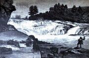
Spokane Falls in 1888
The first humans to live in the Spokane area arrived between twelve to eight thousand years ago and were hunter-gatherer societies that lived off the plentiful game in the area. The Spokane tribe, after which the city is named (which means "children of the sun" or "sun people" in Salishan[9]), are believed to be either direct descendants of the original hunter-gatherers that settled in the region, or descendants of tribes from the Great Plains.[10] When asked by early white explorers, the tribe said their ancestors came from "up North".[10]
Early in the 19th century, the Northwest Fur Company sent two white fur trappers west of the Rocky Mountains to search for fur.[11] The trappers became the first two white men met by the Spokane tribe, who believed them to be Sama, or sacred, and set the trappers up in the Colville River valley for the winter.[12]
Trading post[]
The explorer-geographer David Thompson, working as head of the North West Company's Columbia Department, became the first European to explore the Inland Northwest.[13] Crossing what is now the U.S.–Canadian border from British Columbia, Thompson wanted to expand the North West Company further south in search of furs, primarily beaver. After establishing the Kullyspell House and Saleesh House trading posts in what is now Idaho and Montana, Thompson wanted to expand further west. In 1810, Thompson sent out trappers, Jacques Raphael Finlay and Finan McDonald to the Spokane River to build a trading post in eastern Washington that would exchange with the local Spokane and Colville Indians.[13]
At the confluence of the Little Spokane and Spokane, Finlay and McDonald built a new fur trading post, which was the first long-term European settlement in Washington state.[13] This trading post known as the Spokane House, or simply "Spokane", was in operation from 1810 to 1826.[9] The Spokane House, operated by the British North West Company and, later, the Hudson's Bay Company, was the center of the fur trade between the Rockies and the Cascades for 16 years. When the Hudson's Bay Company absorbed the North West Company in 1821, operations at the Spokane House eventually shifted to Fort Colville; afterward the company still remained active near Spokane.[14]
After the last campaign of the Yakima Indian War, the Coeur d'Alene War of 1858, was brought to a close by the actions of Col. George Wright, who won decisive victories against a confederation of tribes in engagements at the Battle of Four Lakes and the Battle of Spokane Plains, hostilities between the natives ceased and this opened the inter-mountain valley of the Pacific Northwest to the safe settlement of whites.[15]
American settlement[]
Joint American–British occupation of Oregon Country, in effect since the Treaty of 1818, eventually led to the Oregon Boundary Dispute as large influxes of American settlers began arriving by the Oregon Trail. The first American settlers in the present-day city, squatters J.J. Downing and S.R. Scranton, built a cabin and established a claim at Spokane Falls in 1871.[16] Together they built a small sawmill on a claim near the south bank of the Spokane Falls.[16] James N. Glover and Jasper Matheney, Oregonians passing through the region in 1873, recognized the value of the Spokane River and its falls. They realized the investment potential and bought the claims of 160 acres (0.65 km2) and the sawmill from Downing and Scranton for a total of $4,000.[17] Glover and Matheney knew that the Northern Pacific Railroad Company had received a government charter to build a main line across this northern route.[18] Glover later became known as the "Father of Spokane".[19]

Spokane ca. 1895
In 1880, Fort Spokane was established by U.S. Army troops under Lt. Col. Henry Clay Merriam 56 miles (90 km) northwest of Spokane at the junction of the Columbia and Spokane Rivers to protect the construction of the Northern Pacific Railway and secure a place for U.S. settlement.[20] By 1881, the Northern Pacific Railway was completed, bringing major European settlement to the area.[21] The city of Spokan Falls (the "e" was added in 1883 and "Falls" dropped in 1891) was officially incorporated as a city of about 1,000 residents on November 29, 1881.[22][a] The city's population ballooned to 19,922 in 1890, and 36,848 in 1900 with the arrival of the railroads.[23] By 1910, the population hit 104,000 and Spokane eclipsed Walla Walla as the commercial center of the Inland Northwest.[24]
After the 1883 discovery of gold, silver, and lead in the Coeur d'Alene region of northern Idaho, this precipitated a rush of prospectors into the region. The Inland Empire erupted with numerous mining rushes from 1883 to the late 19th century. Mining emerged as a major stimulus to Spokane. At the onset of the initial 1883 gold rush near Coeur d'Alene, Spokane became the outfitter of choice among prospectors due to the areas proximity, lower prices, and convenience of being able to obtain everything "from a horse to a frying pan".[25] It would keep this status for subsequent rushes in the region due to its trade center status and accessibility to railroad infrastructure.[26][b]
Spokane's growth continued unabated until August 4, 1889, when a fire, now known as The Great Fire, began shortly after 6:00 p.m. and destroyed the city's downtown commercial district.[27] Due to technical problems with a pump station, there was no water pressure in the city when the fire started.[28] In an effort to starve the fire, firefighters began demolishing buildings with dynamite. Eventually winds died down and the fire exhausted of its own accord. In the fires' aftermath, 32 blocks of Spokane's downtown were destroyed and one person was killed.[27]
While the damage caused by the fire was a devastating blow, Spokane continued to grow; the fire set the stage for a dramatic building boom.[23][c] After The Great Fire of 1889 and the rebuilding of the downtown, the city was reincorporated under the present name of "Spokane" in 1891.[22] Just three years after the fire, in 1892, James J. Hill's Great Northern Railway had arrived in the newly created township of Hillyard (annexed by Spokane in 1924)—the chosen site for Hill's rail yards.[29] The railroads in Spokane made it a transportation hub for the Inland Northwest region.[30] Spokane became an important rail and shipping center because of its location between mining (particularly Idaho's Silver Valley) and farming areas.[31] After the arrival of the Northern Pacific, the Union Pacific, Great Northern, and Chicago, Milwaukee, St. Paul and Pacific railroads, Spokane became one of the most important rail centers in the western United States.[23][30][32]
20th century[]

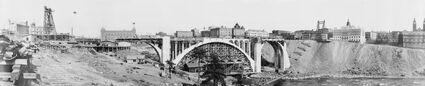
The Monroe Street Bridge, 1911
The expansion and growth of Spokane abruptly stopped in the 1910s and was followed by a period of population decline.[33] Spokane's slowing economy largely contributed to this decline. Control of regional mines and resources became increasingly dominated by national corporations rather than locals, diverting capital outside of Spokane and decreasing growth and investment opportunities in the city.[33]
During this time of stagnation there became unrest among the area's unemployed, who became victimized by "job sharks" who swindled men who applied for jobs. Job sharks charged a fee for signing up workers in the logging camps and employment agencies were known to cheat itinerant workers, with bribes sometimes paid to periodically fire entire work crews, generating repetitive fees.[34] It is around this time in Spokane that the first of many nation-wide free speech fights conducted by the Industrial Workers of the World (IWW) or "Wobblies" had begun, spread, and garnered national attention.[35] In 1908, the IWW launched a campaign led by James H. Walsh with the slogan "Don't Buy Jobs" in the streets around the Spokane employment agencies.[35] More IWW union members from all over the West soon arrived to participate in what was becoming a publicity venture. Within a few weeks the jails were overflowing from those violating the ordinance prohibiting soapboxing. Among those jailed was feminist labor leader Elizabeth Gurley Flynn, who published an account in the local Industrial Worker of her experiences in a Spokane jail.[36]
After mining declined at the turn of the 20th century, agriculture and logging became the primary influences in the Spokane economy.[37] The population explosion and the building of homes, railroads, and mines in northern Idaho and southern British Columbia fueled the industry.[37] Although overshadowed in importance by the vast timbered areas on the coastal regions west of the Cascades, and burdened with cumbersome rail freight rates and stiff competition, Spokane became a noted leader in the manufacture of doors, sash, blinds, and other planing mill products.[38] The oppressive rail freight rates were much higher in Spokane than the rates in coastal cities such as Seattle and Portland, so much so that merchants in Minneapolis could ship goods first to Seattle and then back to Spokane for less than to ship directly to Spokane, even though the rail line ran through Spokane on the way to the coast.[39][d] The 1920s and 1930s saw the similar, but less drastic slow growth of the prior decade. The Inland Northwest region was heavily dependent on extractive products produced from farms, forests, and mines which experienced a fall in demand.[40] Spokane's situation improved with the start of World War II as aluminum production was initiated in Spokane due to the area's inexpensive electricity and the increased demand for airplanes.

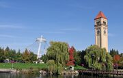
The Great Northern clock tower and U.S. Pavilion in Riverfront Park
After decades of stagnation and slow growth, Spokane businessmen formed Spokane Unlimited, an organization that sought to revitalize downtown Spokane.[41] A recreation park showcasing the Spokane falls was the preferred option, and after the successful negotiation to relocate the railroad facilities on Havermale Island, this allowed the proposal of hosting a world's fair to be realized.[42] Spokane hosted the first environmentally themed World's Fair in Expo '74 on May 4, becoming the smallest city yet to host a World's Fair.[43][44] This event transformed Spokane's downtown, removing a century of railroad industry that built the city and reinvented the urban core. After Expo '74, the fairgrounds became the 100-acre (0.40 km2) Riverfront Park.[45] The late 1970s was a period of growth for Spokane.[46]
The success seen in the late 1970s and early 1980s once again was interrupted by another U.S. recession in which silver, timber, and farm prices dropped. Although a tough period, Spokane's economy had begun to benefit from economic diversification, being the home to growing companies such as Key Tronic and having research, marketing, and assembly plants for other technology companies helped lessen Spokane's dependency on natural resources.[47]
21st century[]
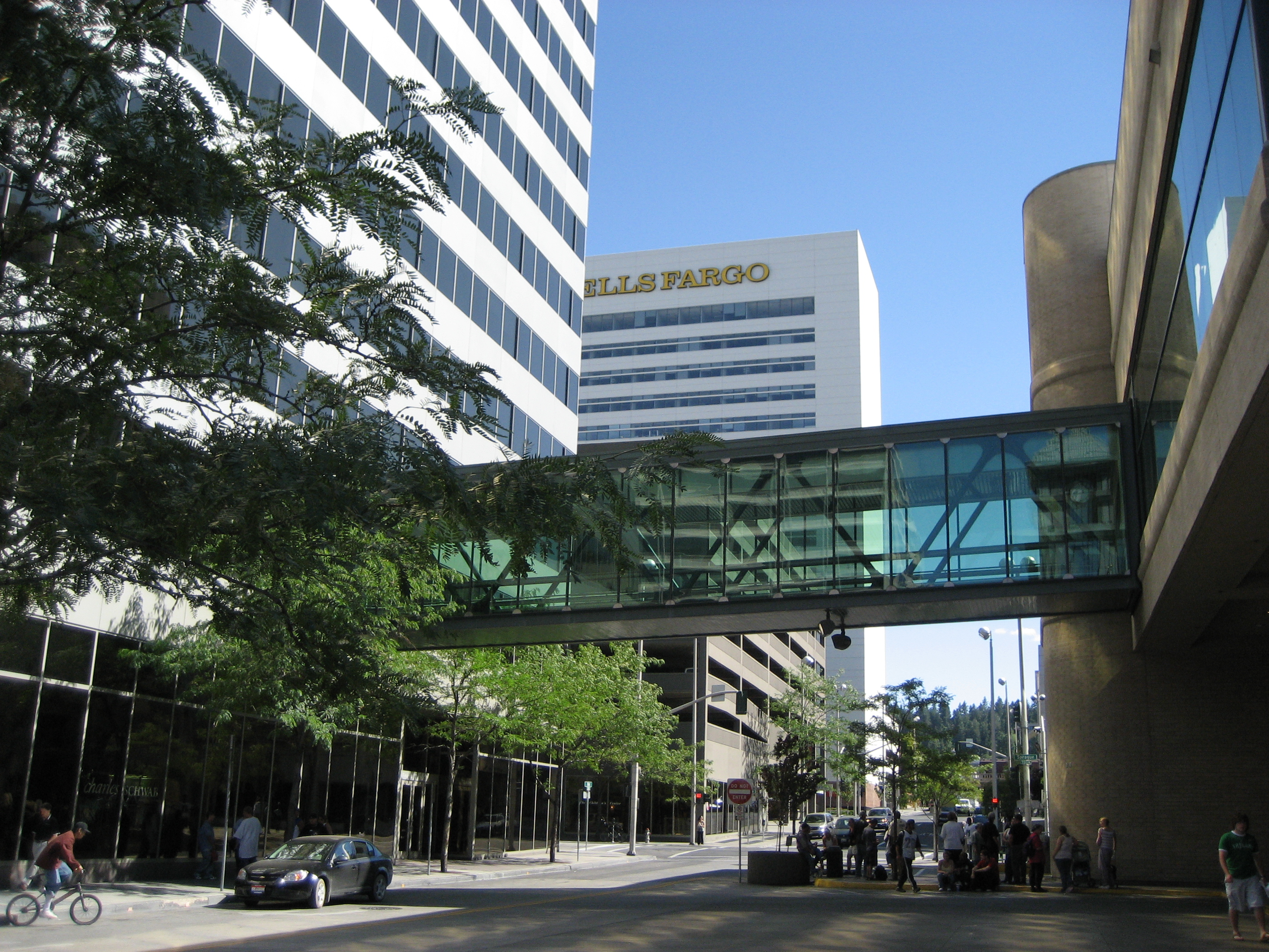
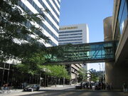
Spokane has an extensive Skywalk network
In the new century, Spokane is still reinventing itself to a more service-oriented economy in the face of a less prominent manufacturing sector.[48] Developing the city's strength in the medical and health sciences fields has been promising, resulting in the expansion of the University District with a medical school. Although the city faces challenges such as relatively low wages, pockets of poverty, areas of high crime, and a sense of doubt regarding aspects of city government, there is an air of optimism for the city's future.[48]
The city has experienced renewed growth since the opening of the River Park Square Mall, initiating a major downtown rebirth that included the building of the Spokane Arena and expansion of the Spokane Convention Center.[48] Other major projects include the building of the Big Easy concert house (now the Knitting Factory), renovation of the historic Montvale Hotel, the Kirtland Cutter-designed Davenport Hotel (after being vacant for over 20 years), and the Fox Theater (now home to the Spokane Symphony).[49][50] The Kendall Yards development on the west side of downtown Spokane is one of the largest construction projects in the city's history. This new "urban village" directly across the Spokane River from downtown will blend residential and retail space with plazas and walking trails.[48]
Geography[]
Topography[]
Spokane is located on the edge of the Columbia Basin on the Spokane River in Eastern Washington, near the eastern border of Washington, about 20 miles (32 km) from Idaho, 110 miles (180 km) south of the Canadian border and 232 miles (373 km) east of Seattle, and 277 miles (446 km) southwest of Calgary.[51] The city lies at the geographical co-ordinates of 47.39 North latitude and 117.25 West longitude. Spokane is part of the Inland Northwest region (long known as the Inland Empire), consisting of eastern Washington, northern Idaho, northwestern Montana, and northeastern Oregon.[52] According to the United States Census Bureau, the city has a total area of 60.02 square miles (155.45 km2), of which, 59.25 square miles (153.46 km2) is land and 0.77 square miles (1.99 km2) is water.[1]

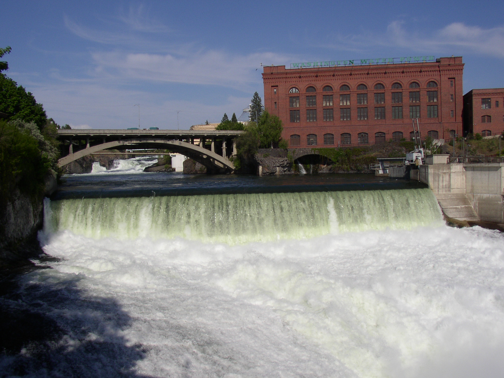
Spokane River flowing by Canada Island
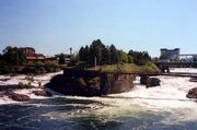
Spokane lies in the Columbia Plateau ecoregion on the eastern edge of the basaltic Channeled Scablands steppe, a plain that then eventually rises sharply to the east towards the rugged, timbered Rocky Mountain foothills, the Selkirk Mountains.[53] It is in a transition area between the barren landscape of the Columbia Basin and the coniferous forests to the east; to the south are the lush prairies of the Palouse.[54] The highest peak in Spokane County is Mount Spokane at an elevation of 5,883 feet (1,793 m), located on the eastern side of the Selkirk Mountains.[55] The most prominent water feature in the area is the Spokane River, a 111-mile (179 km) tributary of the Columbia River, originating from Lake Coeur d'Alene in northern Idaho.[56] The river flows west across the Washington state line through downtown Spokane, meeting Latah Creek, then turns to the northwest where it is joined by the Little Spokane River on its way to join the Columbia River, north of Davenport.[56] Many of the area's numerous large lakes such as Lake Coeur d'Alene and Lake Pend Oreille as well as the Channeled Scablands were formed by the Missoula Floods after the ice-dammed Glacial Lake Missoula ruptured at the end of the last ice age.[57]
Spokane is at an elevation of 1,843 feet (562 m) above sea level.[58] The lowest elevation in the city of Spokane is the northernmost point of the Spokane River within city limits (in Riverside State Park) at 1,608 feet (490 m) and the highest elevation is on the northeast side near the community of Hillyard, though closer to Beacon Hill and the North Hill Reservoir at 2,591 feet (790 m).[59]
Climate[]
Spokane lies in the transitional zone between the semi-arid climate type and the sub-humid (dry-summer continental) climate (Köppen BSk and Dsa) ; Spokane, however is adjacent to and sometimes even classified as a "cool-summer Mediterranean climate" (Csb) as well because the average temperature for the coldest month is just over 27 °F (−3 °C).[60]
The area is typified by a hot, arid climate during the summer months and a cold, snowy, and moist climate in the winter.[53] Both summer and winter are the predominant seasons, as spring and fall constitute a rapid transition. On average, July and August are equally warm, and the coolest month is December.[61] Daily temperature ranges are large during the summer, approaching, and often exceeding 30 °F (17 °C), and small during the winter, with a range just above 10 °F (5.6 °C). December, the coldest month, averages 27.4 °F (−2.6 °C), while July, the warmest month, averages 69.8 °F (21.0 °C). Extremes range from 112 °F (44 °C) to −30 °F (−34.4 °C), but temperatures of more than 100 °F (38 °C) and less than −10 °F (−23.3 °C) are rare,[53] though on average, temperatures above 90 °F (32 °C) occur on 19 days, above 100 °F (38 °C) usually at least once, and below 0 °F (−18 °C) on 3.5 days annually.[62] Spokane has a slight heat island effect, Due to this during the summer months on average downtown is 1 °F (0.6 °C) warmer than surrounding areas during the day, this combined with the fact that downtown is about 500 ft lower than the airport; in downtown the average summer high is actually 88 °F (31 °C) and it has reached an extreme of 112 °F (44 °C).
Because of Spokane's location between the Cascades Range to the west and Rocky Mountains to the east and north, the city is protected from weather patterns experienced in other parts of the Pacific Northwest. The Cascade Mountains form a barrier to the eastward flow of moist and relatively mild air from the Pacific Ocean in winter and cool air in summer.[63] As a result of the rain shadow effect of the Cascade Mountains, the Spokane area also has less than half the rainfall of Seattle. The average annual precipitation in the Spokane area is 16.5 inches (420 mm), whereas the Seattle area receives 37 inches (940 mm) annually.[63] The most precipitation occurs in December, and summer is the driest time of the year.[61] The Rocky Mountains shield Spokane from the winter season's cold air masses traveling southward across Canada, sparing the city from the worst effects of Arctic air in winter.[63]
| Climate data for Spokane, Washington (Spokane Int'l), 1981–2010 normals | |||||||||||||
|---|---|---|---|---|---|---|---|---|---|---|---|---|---|
| Month | Jan | Feb | Mar | Apr | May | Jun | Jul | Aug | Sep | Oct | Nov | Dec | Year |
| Record high °F (°C) | 62 (17) |
63 (17) |
74 (23) |
90 (32) |
97 (36) |
101 (38) |
108 (42) |
108 (42) |
98 (37) |
87 (31) |
70 (21) |
60 (16) |
108 (42) |
| Average high °F (°C) | 34.4 (1.3) |
39.6 (4.2) |
48.9 (9.4) |
57.2 (14.0) |
66.4 (19.1) |
73.8 (23.2) |
83 (28.3) |
83 (28.3) |
72.9 (22.7) |
58.0 (14.4) |
41.6 (5.3) |
32.2 (0.1) |
57.6 (14.2) |
| Daily mean °F (°C) | 29.55 (−1.36) |
33 (1) |
40.25 (4.58) |
47 (8) |
55.1 (12.8) |
62.1 (16.7) |
69.65 (20.92) |
69.4 (20.8) |
60.3 (15.7) |
47.6 (8.7) |
35.7 (2.1) |
27.35 (−2.58) |
48.083 (8.935) |
| Average low °F (°C) | 24.7 (−4.1) |
26.4 (−3.1) |
31.6 (−0.2) |
36.8 (2.7) |
43.8 (6.6) |
50.4 (10.2) |
56.3 (13.5) |
55.8 (13.2) |
47.4 (8.6) |
37.2 (2.9) |
29.8 (−1.2) |
22.5 (−5.3) |
38.6 (3.7) |
| Record low °F (°C) | −30 (−34) |
−24 (−31) |
−10 (−23) |
14 (−10) |
24 (−4) |
33 (1) |
37 (3) |
35 (2) |
22 (−6) |
7 (−14) |
−21 (−29) |
−25 (−32) |
−30 (−34) |
| Precipitation inches (mm) | 1.79 (45.5) |
1.33 (33.8) |
1.61 (40.9) |
1.28 (32.5) |
1.62 (41.1) |
1.25 (31.8) |
0.64 (16.3) |
0.59 (15) |
0.67 (17) |
1.18 (30) |
2.30 (58.4) |
2.29 (58.2) |
16.55 (420.4) |
| Snowfall inches (cm) | 12.0 (30.5) |
7.2 (18.3) |
3.7 (9.4) |
1.0 (2.5) |
0.1 (0.3) |
0 (0) |
0 (0) |
0 (0) |
0 (0) |
0.1 (0.3) |
7.2 (18.3) |
14.9 (37.8) |
46.2 (117.3) |
| Avg. precipitation days (≥ 0.01 in) | 13.4 | 10.4 | 11.6 | 10.1 | 10.2 | 7.9 | 5.0 | 3.8 | 5.1 | 7.8 | 13.7 | 13.2 | 112.2 |
| Avg. snowy days (≥ 0.1 in) | 8.9 | 5.1 | 4.1 | 1.1 | 0.3 | 0 | 0 | 0 | 0 | 0.2 | 4.7 | 9.8 | 34.2 |
| % humidity | 62.0 | 81.5 | 75.0 | 66.5 | 60.5 | 58.0 | 50.5 | 45.5 | 49.0 | 57.0 | 68.0 | 81.5 | 80.5 |
| Percent possible sunshine | 28 | 41 | 55 | 61 | 65 | 67 | 80 | 78 | 72 | 55 | 29 | 23 | 55 |
| Source: NOAA (extremes 1881–present, percent sunshine through 2009)[62][64] | |||||||||||||
Neighborhoods[]
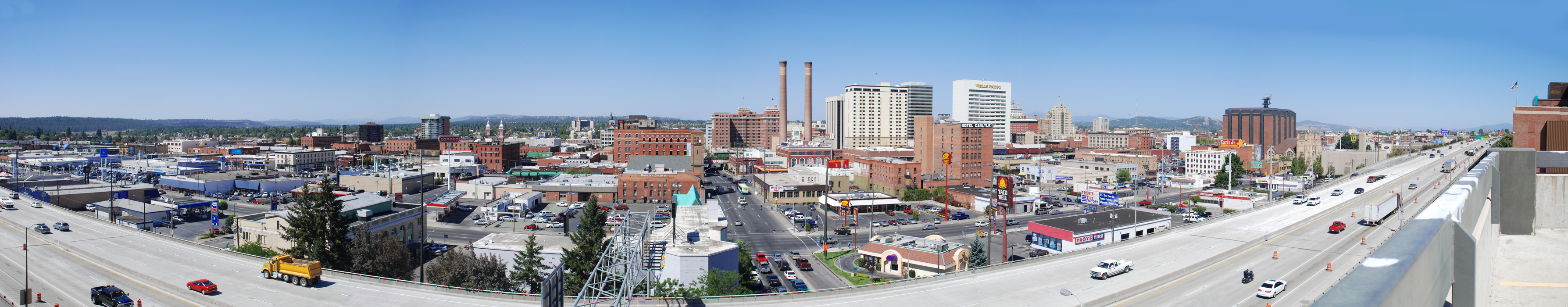
Much of Spokane's history is reflected in its large variety of neighborhoods. Neighborhoods range from the Victorian-era style South Hill and Browne's Addition, to the Davenport Arts District of Downtown, to the more contemporary neighborhoods of North Spokane. Spokane's neighborhoods are gaining attention for their history, as illustrated by the city being home to 18 recognized National Register Historical Districts.[44][65][66] Division Street splits the city into East and West; Sprague Avenue divides the city into North and South.[67]


Patsy Clark Mansion in Browne's Addition
Some of Spokane's most prominent neighborhoods are the Riverside, Browne's Addition, and Hillyard neighborhoods. The Riverside neighborhood consists primarily of downtown Spokane and is the central business district of Spokane. The neighborhoods south of downtown Spokane are generally known as the South Hill. Downtown Spokane contains many of the city's public facilities, including City Hall, Riverfront Park (site of Expo '74), the Spokane Convention Center and INB Performing Arts Center, Mobius Science Center, the Spokane Arena as well as the Spokane County Courthouse across the river in the historic West Central neighborhood. The Monroe Street Bridge, a city icon featured in the city's seal, connects the two areas. To the east of downtown is East Central and the adjacent University District and International District. To the west of downtown is one of Spokane's oldest and densest neighborhoods, Browne's Addition. A National Historic District west of Downtown, Browne's Addition was Spokane's first prestigious address, notable for its array of old mansions built by Spokane's early elite in the Queen Anne and early Craftsman styles.[66] The area houses the Northwest Museum of Arts and Culture. In northeast Spokane, the Hillyard neighborhood came about due to James J. Hill's Great Northern Railway yard, strategically placed outside Spokane city limits to avoid "burdensome taxes". The downtown Hillyard Business District, located on Market Street, became Spokane's first neighborhood to be listed in the National Register of Historic Places.[29] Many of the former town's houses were built to house railroad workers, many immigrant laborers working in the local yard, who gave Hillyard an independent, blue-collar character. Hillyard still caters to new arrivals, becoming a popular home for Spokane's growing Russian, Ukrainian, and Southeast Asian communities.[29]
Walkability[]
Spokane has an average Walk Score of 54 and is rated "Somewhat Walkable".[68] The Spokane area has experienced the negative affects of suburbanization and urban sprawl in past decades despite Washington's use of urban growth boundaries; the city ranks low among major Northwest cities in population density and smart growth.[69] It is a matter of debate whether the completion of the North Spokane Corridor will exacerbate this situation further by increasing mobility.[70]
Cityscape[]
Surrounding communities[]

|
Nine Mile Falls | Country Homes Town and Country |
Mead |
|
| Airway Heights | Millwood Spokane Valley | |||
 Spokane | ||||
| Cheney | Palouse | Mica |
Metropolitan area[]

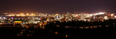
Spokane at night from the southwest
The Spokane metropolitan area consists of Spokane and its surrounding communities. Spokane Valley, Four Lakes, Washington, Medical Lake, Cheney, Airway Heights, Nine Mile Falls, Deer Park, Mead, Millwood, and Liberty Lake are included in this metropolitan region. As of the 2010 census, the region had a population of 471,221.[71] Directly east of Spokane County is the Coeur d'Alene Metropolitan Statistical Area, composed entirely of Kootenai County, Idaho. Coeur d'Alene anchors the Idaho portion of the agglomeration, which includes Post Falls, Rathdrum, and Hayden. The urban form of the agglomeration largely follows the path of Interstate 90 between the two cities. Both the Spokane and Coeur d'Alene Metropolitan Statistical Areas (MSA) have been merged into one Combined Statistical Area (CSA) by the Office of Management and Budget but still remain distinct statistical entities.[72] The leadership of the city of Coeur d'Alene has repeatedly resisted joining the Spokane MSA due to their concerns of diminishing or losing the city's image as a scenic, resort town. The Spokane–Coeur d'Alene CSA has roughly 609,000 residents.[72]
Demographics[]
| Historical populations | |||
|---|---|---|---|
| Census | Pop. | %± | |
| 1880 | 350 | ||
| 1890 | 19,922 | 5,592.0% | |
| 1900 | 36,848 | 85.0% | |
| 1910 | 104,402 | 183.3% | |
| 1920 | 104,437 | 0% | |
| 1930 | 115,514 | 10.6% | |
| 1940 | 122,001 | 5.6% | |
| 1950 | 161,721 | 32.6% | |
| 1960 | 181,608 | 12.3% | |
| 1970 | 170,516 | −6.1% | |
| 1980 | 171,300 | 0.5% | |
| 1990 | 177,196 | 3.4% | |
| 2000 | 195,629 | 10.4% | |
| 2010 | 208,916 | 6.8% | |
| Est. 2012 | 209,525 | 7.1% | |
| source:[73] 2012 Estimate[75] | |||
According to the 2000 census, the median income for a household in the city was $32,273, and the median income for a family was $41,316. Males had a median income of $31,676 versus $24,833 for females. The per capita income for the city was $18,451. About 11.1% of families and 15.9% of the population were below the poverty line, including 19.3% of those under the age of 18 and 9.6% of those ages 65 and older.
At the 2010 census,[2] there were 208,916 people, 87,271 households, and 49,204 families residing in the city. The population density was 3,526.0 inhabitants per square mile (1,361.4 /km2). There were 94,291 housing units at an average density of 1,591.4 per square mile (614.4 /km2). The racial makeup of the city was 83.2% White, 2.8% African American, 2.0% Native American, 3.0% Asian, 0.6% Pacific Islander, 1.3% from other races, and 4.6% from two or more races. Hispanic or Latino of any race were 6.0% of the population.
There were 87,271 households out of which 28.9% had children under the age of 18 living with them, 38.5% were married couples living together, 12.9% had a female householder with no husband present, 5.0% had a male householder with no wife present, and 43.6% were non-families. 34.2% of all households were made up of individuals and 11% had someone living alone who was 65 years of age or older. The average household size was 2.31 and the average family size was 2.97.[2]
The median age in the city was 35 years. 22.4% of residents were under the age of 18; 12.3% were between the ages of 18 and 24; 27.6% were from 25 to 44; 25.1% were from 45 to 64; and 12.8% were 65 years of age or older. The gender makeup of the city was 48.8% male and 51.2% female.[2]
According to the Association of Religion Data Archives' 2000 Metro Area Membership Report, the denominational groups of the Spokane MSA are 43,397 Evangelical Protestant; 32,207 Mainline Protestant; 776 Orthodox; 57,187 Catholic; 17,351 Other; and 267,021 Unclaimed.[76] Spokane, like Washington and the Pacific Northwest region as a whole is part of the Unchurched Belt, a region characterized by low church membership rates and religious participation.[77]
Economy[]


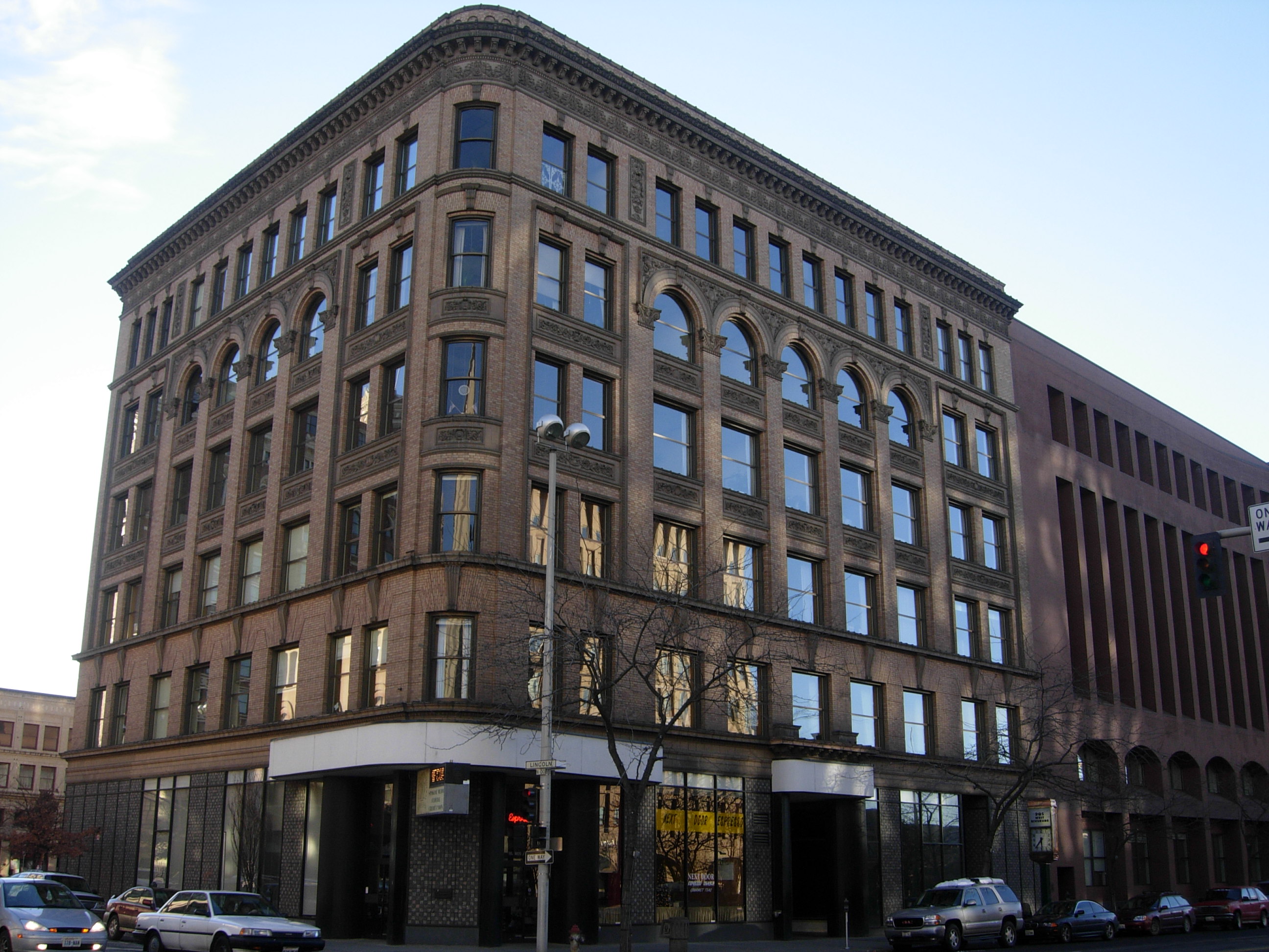
The Spokane Stock Exchange once occupied The Peyton Building
Spokane became an important rail and shipping center because of its location between mining and farming areas.[31] In the early 1880s, gold and silver were discovered in the Inland Empire; as a regional shipping center, the city furnished supplies to the miners who passed through on their way to mine in the Coeur d'Alene, Colville and Kootenay districts.[78] The area is considered to be one of the most productive mining districts in North America.[79]
Natural resources have historically been the foundation of Spokane's economy, with the mining, logging, and agriculture industries providing much of the region's economic activity. After mining declined at the turn of the 20th century, agriculture and logging replaced mining as the primary influence in the economic development of Spokane.[37] As with the mining industry, the lumber industry in the city contributed to the economy by the means of outfitting the lumberjacks and millmen working in the hundreds of mills along the railroads, rivers, and lakes of northern Washington and Idaho.[80] Agriculture has always been an important sector to Spokane's economy; the surrounding area, especially to the south, is a productive agricultural region known as the Palouse. This setting supports many vineyards and microbreweries that reside in the Spokane area.[81] By the early 20th century Spokane was primarily a commercial center rather than an industrial center.[82] As the metropolitan center of the Inland Northwest as well as southeastern British Columbia and Alberta, Spokane serves as a commercial, manufacturing, transportation, medical, shopping, and entertainment hub.[83]

Empire State Building
In Spokane, wood and food processing, printing and publishing, primary metal refining and fabrication, electrical and computer equipment, and transportation equipment are leaders in the manufacturing sector.[83] Fortune 1000 company, Potlatch Corporation, which operates as a real estate investment trust is headquartered in the city proper.[84] Forestry and agribusiness continue to be important elements in the local economy, but Spokane's economy has diversified to include other industries, including the high-tech and biotech sectors.[47] Genetics company, Signature Genomic Laboratories and Fortune 1000 technology company, Itron are headquartered in the area.[85][86] Other companies with head offices in the Spokane area include technology company, Key Tronic, hotelier, Red Lion Hotels Corporation, and automaker, Commuter Cars.[87][88] The largest military facility and employer in the area is Fairchild Air Force Base near Airway Heights, where the 92d Air Refueling Wing is stationed.[89]
In 2000, the leading industries in Spokane for the employed population 16 years and older were educational services, health care, and social assistance, 23.8 percent, and retail trade, 12.7 percent.[90] The health care industry is a large and increasingly important industry in Spokane; the city provides specialized care to many patients from the surrounding Inland Northwest and as far north as the Canadian border.
Companies have located or relocated to the Spokane area, drawn by the easy access to raw materials and lower operating costs, such as cheap hydroelectric power.[91][92] Economic development in the Spokane area primarily focuses on promoting six industries which include manufacturing, aerospace manufacturing, health sciences, information technology, clean technology, and digital media.[93]
Culture[]


Northwest Museum of Arts and Culture
Life in Spokane is heavily influenced by its climate and geographical location. Spokane experiences a four-season climate, and is close to dozens of lakes and rivers for swimming, boating, rafting, and fishing, as well as mountains for skiing, hiking, biking and sightseeing according to CNN.[94] The Turnbull National Wildlife Refuge south of Cheney is the closest natural reserve and the closest national park is Glacier National Park, approximately a four-hour drive away from Spokane.
Spokane is big enough to have many amenities of a larger city, but small enough to support annual events and traditions with a small town atmosphere. Spokane was awarded the All-America City Award by the National Civic League in 1974 and 2004.[95] There are several museums in the city, most notably the Northwest Museum of Arts and Culture, a Smithsonian affiliate museum that houses a large collection of Native American artifacts as well as regional and national traveling art exhibits.[96][97] Located in Browne's Addition amid the mansions of Spokane's late 19th-century "Age of Elegance", the Museum is in a secluded setting a few blocks from the center of downtown. The Mobius Science Center and the related Mobius Kid's Museum in downtown Spokane seek to provide the public with new and innovative ways to learn about science, technology, engineering, and math and allow youth to explore science, culture, and the arts through a hands-on experience.[98]
Arts and theater[]


The Fox Theater
Spokane hosts a variety of visual and performing arts scenes. These attractions include a major civic theater as well as several smaller ones, the Spokane Symphony Orchestra, a jazz orchestra, an opera house, and other musical venues. The Davenport District is also home to many art galleries as well as some of Spokane's main performing arts venues. The Metropolitan Performing Arts Center was restored in 1988 and renamed Bing Crosby Theater in honor of Spokane native Bing Crosby, in 2006.[99] The Fox Theater, which has been restored to its original 1931 Art Deco state, is the home of the Spokane Symphony.
Spokane has a vibrant art scene. Spokane's two main Artwalk dates (the first Friday of February and October) attract large crowds to the art districts. Spokane's main art districts are located in the Davenport District, the Garland Business District, and East Sprague.[100] The First Friday Artwalk, which occurs the first Friday of every month, is dedicated to local vendors and performers displaying art around Downtown.[101]
Spokane offers an array of musical performances catering to a variety of interests. Spokane's local music scene, however, is considered somewhat lacking by some, and critics have identified a need for a legitimate all-ages venue for music performances.[102] The Spokane Symphony presents a full season of classical music, and the Spokane Jazz Orchestra, a full season of jazz music.[103] The Spokane Jazz Orchestra is a non-profit organization formed in 1962 that claims to be the nation's oldest, continually performing, professional, and community-supported 17-piece big band.[104]
Theater is provided by Spokane's only resident professional company, Interplayers Ensemble.[105] Theater is also provided by the Spokane Civic Theatre and several amateur community theaters and smaller groups.
Parks and recreation[]
The Spokane area offers an abundance of outdoor activities that can be enjoyed in outlying natural areas that may cater to a variety of interests. In 1907, Spokane's board of park commissioners retained the services of the Olmsted Brothers to draw up a plan for Spokane's parks.[106] Much of Spokane's park land was acquired by the city prior to World War I, establishing the city early on as a leader among Western cities in the development of a city-wide park system.[107][108] Today, Spokane has a system of over 87 parks totaling 4,100 acres (16.6 km2).[109] This system includes six neighborhood aquatic centers. Some of the most notable parks in Spokane's extensive park system are Riverfront Park, Manito Park and Botanical Gardens, Riverside State Park, Mount Spokane State Park, Saint Michael's Mission State Park, John A. Finch Arboretum, and the Dishman Hills Conservation Area.
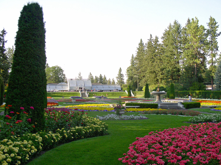
Duncan Garden at Manito Park
Riverfront Park, created after Expo '74 and occupying the same site, is 100 acres (0.40 km2) in downtown Spokane and the site of some of Spokane's largest events.[110] The park has views of the Spokane Falls, and holds a number of civic attractions, including a Skyride that is a rebuilt gondola lift that carries visitors across the falls from high above the river gorge, a 5-story IMAX theater, and a small amusement park (which is converted into an ice-skating rink, the "Ice Palace", during the winter months).[110] The park is host to a full schedule of family entertainment and events such as the Bloomsday Post-Race Celebration, Hoopfest, First Night Spokane, and outdoor concerts and other community activities. The park also includes the historic, hand-carved Riverfront Park Looff carousel created in 1909 by Charles I. D. Looff.[110] The carousel still operates in Riverfront Park, where riders can participate in an old-time ring toss. Manito Park and Botanical Gardens, on Spokane's South Hill, has a duck pond, a central conservatory, Duncan Gardens, a classical European Renaissance style garden, and the Nishinomiya Japanese Garden designed by Nagao Sakurai. Riverside State Park, is a park close to downtown that is a popular site for hiking, mountain biking, and rafting.
A more active way to see natural sites in the Spokane area include travelling the Spokane River Centennial Trail, which features over 37 miles (60 km) of paved trails running along the Spokane River from Sontag Park in west Spokane to the east shore of Lake Coeur d'Alene in Coeur d'Alene, Idaho.[111] This trail continues on for 24 miles (39 km) as the North Idaho Centennial Trail in Idaho and is often used for alternative transportation and recreational use. In addition to the park system within the city, there are many natural areas where outdoors activities can be enjoyed close by. In the summer, it has long been popular to visit North Idaho's "Lake Country", such as Lake Coeur d'Alene, Lake Pend Oreille, or Priest Lake or one of the other nearby bodies of water and beaches to fish, swim, hike, kayak, golf, sail, or stargaze.[112] A park of a different sort, the Silverwood Theme Park just north of Coeur d'Alene also draws large crowds of area residents during the warm summer months.[113] In the winter, the public has access to five ski resorts within a couple hours of the city. The closest of these is the Mt. Spokane Ski and Snowboard Park, operated by a non-profit organization.[114] Mt. Spokane has trails for cross-country skiing, snowshoeing, snowmobiling, and dog sledding.[115]
Events and activities[]
Spokane is home to annual events and attractions that draw people from the surrounding area. The Lilac Bloomsday Run, held on the first Sunday of each May, is a 7.46-mile (12.01 km) race for competitive runners as well as walkers that attracts international competition.[116] Also held in the city is Spokane Hoopfest, which claims to be the largest 3-on-3 basketball tournament in the world.[117] The Spokefest family bicycle ride is held each September, utilizing a route that takes bicyclists along the same route as Bloomsday through the scenic Spokane River Gorge and offering alternative routes of various distances along with a family "Spokefair" in Riverfront Park. Every year in May, Spokane hosts the Lilac Festival which honors the military, celebrates youth, and showcases the region.[118] Spokane's nickname, the "Lilac City," is in reference to the flowers that have flourished since their introduction to the area in the early 20th century.[119]


Lilac Bloomsday Run
Other notable events in Spokane include the Spokane Interstate Fair, Spokane Comic Con, and Japan week. The Spokane Interstate Fair is held annually in September at the Spokane Fair and Expo Center.[120] Japan Week is held in April and celebrates the sister-city relationship with Nishinomiya, Hyogo, demonstrating the many commonalities shared between the two cities.[121] Students from the Spokane campus of Mukogawa Fort Wright Institute, Gonzaga University, Whitworth University, and other area schools organize an array of Japanese cultural events.
Sports[]

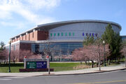
Spokane Arena, home of the Spokane Chiefs and Spokane Shock
Spokane's professional and semi-professional sports teams include the Spokane Indians in Minor League Baseball, Spokane Shock in arena football, Spokane Shine in soccer, and Spokane Chiefs in junior ice hockey.[122]
Collegiate sports in Spokane focus on the local teams such as the Gonzaga Bulldogs that compete in the West Coast Conference and the Whitworth Pirates as well as other regional teams including the Washington State Cougars, Eastern Washington Eagles, and the Idaho Vandals.
The Spokane Veterans Memorial Arena is Spokane's premier sports venue. In the years since the Spokane Arena opened, it along with the city of Spokane has played host to several major sporting events. The first major event was the 1998 Memorial Cup, the championship game of the Canadian Hockey League.[123] Four years later in 2002, Spokane hosted the 2002 Skate America figure skating competition[124] and then the 2007 U.S. Figure Skating Championships in the Spokane Arena.[125] The latter event set an attendance record, selling nearly 155,000 tickets and was later named the "Sports Event of the Year" by Sports Travel Magazine, beating out events such as Super Bowl XLI.[126] Spokane once again hosted the 2010 U.S. Figure Skating Championships—ending eighteen days before the start of the 2010 Winter Olympics in Vancouver, British Columbia.[125]
| Club | Sport | League | Venue |
|---|---|---|---|
| Spokane Indians | Baseball | Northwest League (Eastern Division) | Avista Stadium |
| Spokane Shock | Arena Football | Arena Football League | Spokane Arena |
| Spokane Shine | Soccer | Women's Premier Soccer League (Pacific – North Division) | Joe Albi Stadium |
| Spokane Chiefs | Ice hockey | Western Hockey League (U.S. Division) | Spokane Arena |
Media[]


The Review Building
Spokane is served by a variety of print media. Newspaper service includes its only major daily newspaper, The Spokesman-Review,[127] as well as other more specialized publications including the weekly alternative newspaper, The Pacific Northwest Inlander,[128] and the bi-weekly business journal, The Spokane Journal of Business.[129] Other publications include the student-run The Gonzaga Bulletin, a monthly newspaper for parents, Kids newspaper, and the monthly GLBT newsmagazine, Q View Northwest. Spokane also has several community magazines such as the monthly paper covering the Garland neighborhood, The Garland Times and, Spokane Coeur d'Alene Living a monthly home and lifestyle magazine.
According to Arbitron, Spokane is the 94th largest radio market in the United States with 526,900 listeners aged 12 and over.[130] Twenty-eight AM and FM radio stations broadcast in Spokane.[131] Spokane also has a full-power community radio station, KYRS. KYRS serves the Spokane area with progressive perspectives, providing programming to diverse communities and unserved or under-served groups.
Spokane is the 73rd largest television market in the United States, accounting for 0.372% of the total TV households in the United States.[132] Spokane has six television stations representing the major commercial networks and public television.[133] The city is the television broadcast center for much of eastern Washington (except the Yakima and Tri-Cities area), northern Idaho, northwestern Montana, northeastern Oregon, and parts of Canada (by cable television).
For many years, KHQ-6 (NBC) (Spokane's first television station, signing on the air in 1952), KREM-2 (ABC/CBS), and KSPS-7 (PBS) operated on three opposite corners of Regal Street and Thurston Avenue on the south hill neighborhood of Moran Prairie. The "missing" station, KXLY-4 (CBS/ABC), partly founded by entertainer Bing Crosby, was built in 1953 on Boone Avenue, just west of Gonzaga University (Crosby's alma mater). KXLY was also the only station to place its tower on Mount Spokane, instead of the mountains on the city's southeast side. In 1976, KREM and KXLY swapped network affiliates, at the insistence of CBS. Spokane had no UHF stations until 1982 when KAYU-28 signed on, which soon became a FOX affiliate. In 2001, KHQ-6 moved into a new all-digital studio in downtown, leaving only two stations remaining at the same intersection.[134][135]
Spokane receives broadcasts in the Pacific Time Zone, with weekday prime time beginning at 8 pm. Montana and Alberta, Canada are in the Mountain Time Zone and receive Spokane broadcasts one hour later by their local time. The current major network television affiliates include KREM (TV) 2 (CBS), KXLY-TV 4 (ABC), KHQ-TV 6 (NBC), KSKN-TV 22 (The CW), KAYU 28 (FOX), KSPS-TV 7 (PBS), and KCDT-TV 26 (PBS operating out of Coeur d'Alene, Idaho).[133]
Government and politics[]
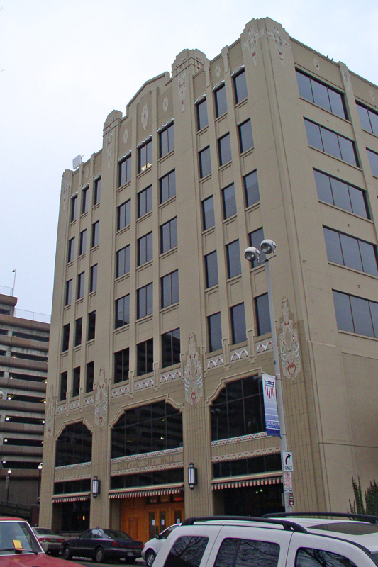
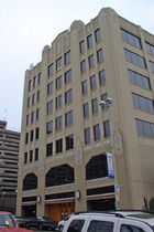
Spokane City Hall
Since 2001, the City of Spokane has operated under a mayor−council form of government, also referred to as a "strong mayor".[136] Under the strong mayor form of government, there are two distinct branches of government: the executive (mayor) and the legislative (city council).[137] The city council sets the policy direction for the city and has seven members plus the city council president.[138] The mayor, as the chief executive officer for the City of Spokane, is in charge of operating city government and implementing the policies developed by the city council.
In 2011, David Condon was elected mayor of Spokane as a non-partisan candidate, taking office on the last business day of the year.[139] The previous mayor was Mary Verner, who succeeded the recalled James "Jim" West. Spokane voters haven't re-elected a mayor since 1973, when incumbent David H. Rodgers was granted a second term.

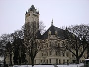
Spokane County Courthouse
In Washington state, Spokane is the county seat of Spokane County, which it wrested from Cheney in 1886.[140][141] The Governor of Washington is Democrat Jay Inslee, elected in 2012.[142] Federally, Spokane is part of Washington's 5th congressional district, represented by Republican Cathy McMorris Rodgers, elected in 2004.[143] This district and Washington state are represented nationally by the state's senior member of the Senate, Democrat Patty Murray and Democrat Maria Cantwell.[143] Spokane County favored Mitt Romney over Barack Obama by 51.7 percent to 45.6 percent in the 2012 general election.[144] In 2012, Spokane County supported the legalization of recreational marijuana ballot measure 52 to 48 percent but opposed the legalization of same-sex marriage 44.1 to 55.9 percent.[144]
Spokane's most prominent politician, former Democratic Speaker of the U.S. House of Representatives Tom Foley served as a representative of Washington's 5th district for 30 years, enjoying large support from Spokane, until his narrow defeat in the "Republican Revolution" of 1994.[145] This was one of the few times United States voters have turned out a sitting Speaker of the House, the first time since the 1860s. The city elected James Everett Chase as its first African-American mayor in 1981, and after his retirement, elected the city's first woman mayor, Vicki McNeil.[146][147]
Crime[]
The crime rate per 1,000 people in the Spokane metropolitan area (Spokane County) was 55.7, this is higher than the Washington state average of 38.3 in 2011; the violent crime rate of 3.5 and property crime rate of 52.3 also exceed the statewide averages of 2.9 and 35.4 respectively.[148] Nationally, Spokane's crime rate is also higher than average in both violent and property crime, having a rate higher than 98% of communities in the United States.[149]
Crime rates in Spokane can vary greatly and differ depending on neighborhood. The most crimes reported in the city tend to be focused around the downtown city center and its surrounding environs.[149] Half of all property crimes are localized in about 6.5 percent of the city.[150] Property crime is of particular concern in Spokane; an individual in Spokane has a one in 14 chance of becoming a victim of burglary, larceny, motor vehicle theft, or arson.[149] In regard to the most common property crime in the nation, auto theft, Spokane had the fourth-highest rate in the United States in 2010 and 2011 according to the National Insurance Crime Bureau.[150] Local and regional law enforcement agencies continually try new strategies, techniques, and technologies to address this issue.
Education[]

St. Aloysius Church at Gonzaga University
Serving the general educational needs of the local population are two public library districts, the Spokane Public Library (within city limits) and the Spokane County Library District. Founded in 1904 with funding from philanthropist Andrew Carnegie, the Spokane Public Library system comprises a downtown library overlooking Spokane Falls and five branch libraries.[151] Special collections include Northwest history, genealogy, Washington state, and Spokane County government documents.[152]
Spokane Public Schools (District 81) is the largest public school system in Spokane and the second largest in the state, serving roughly 30,000 students in five high schools, six middle schools, and 34 elementary schools.[153] Other public schools in Spokane include the Mead School District, though most of the district is north of Spokane city limits.[154][155] A variety of state-approved private and parochial elementary and secondary schools augment the public school system. The Roman Catholic Diocese of Spokane manages 11 such schools in Spokane.[156]
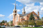
Spokane is home to many higher education institutions. They include the private universities, Gonzaga and Whitworth, and the public Community Colleges of Spokane system as well as a variety of technical colleges. Gonzaga University and Law School was founded by the Jesuits in 1887.[157] Whitworth was founded in 1890 and is affiliated with the Presbyterian Church.[158] While Spokane is one of the larger cities in the United States to lack a main campus of a state-supported university within its city limits, Eastern Washington University (EWU) and Washington State University (WSU) have operations at the Riverpoint Campus, just adjacent to downtown and across the Spokane River from the Gonzaga campus.[159][160] Washington State University Spokane is WSU's health sciences campus and houses the school's College of Nursing and College of Pharmacy in addition to a four-year medical school branch in collaboration with the University of Washington.[161] The main EWU campus is located 15 miles (24 km) southwest of Spokane in nearby Cheney, and WSU is located 65 miles (105 km) to the south in Pullman. An international branch campus of the Mukogawa Women's University, the Mukogawa Fort Wright Institute, is located in Spokane.[162]
Infrastructure[]

Deaconess Medical Center
Healthcare[]
Spokane is the hub for medical services in the Inland Northwest. Six major hospitals are located in Spokane, four of which are full service facilities.[163] The region's healthcare needs are served primarily by non-profit Seattle-based Providence Health & Services and for-profit Tennessee-based Community Health Systems, who run the two biggest hospitals in Spokane, Sacred Heart Medical Center, and Deaconess Medical Center, respectively. These two hospitals, along with a majority of Spokane's major health care facilities are located on Spokane's Lower-South Hill, just south of downtown. The close proximity of the hospitals, doctors' offices, and specialized clinics scattered around this area, form what is known as the "Medical District" of Spokane.
Other hospitals in the area include the Spokane Veterans Affairs Medical Center in the northwest part of town, Holy Family Hospital on the north side, and Valley Hospital and Medical Center in Spokane Valley. One of the twenty Shriners Hospitals in the United States is also located in Spokane.[164] One of Washington's two state psychiatric hospitals, Eastern State Hospital is located 15 miles (24 km) away in Medical Lake.[165]
Transportation[]
Roads and highways[]
Spokane's streets use a street grid that is oriented to the four cardinal directions. Generally, in Spokane the east-west roads are designated as avenues, and the north−south roads are referred to as streets. The typical block geometry is square and is 330 feet (1/16th of a mile) in length from the center-line of each intersecting street or avenue. Addresses on east-west avenues are numbered based upon the number of blocks away from Division Street. Addresses on north-south streets are based upon the distance from Sprague Avenue. The intersection of Sprague Avenue and Division Street is the basis for a uniform address numbering system that covers most of Spokane County. Even-numbered addresses on avenues are on your right hand when traveling away from Division Street (in the case of avenues) or Sprague Avenue (in the case of streets).
Major east−west thoroughfares in the city include Francis, Wellesley, Mission, Sprague, and 29th Avenues. Major north−south thoroughfares include Maple−Ash, Monroe, Division, Hamilton, Greene-Market (north of I-90), and Ray-Freya (south of I-90) Streets. With over 40,000 vehicles per day Average Daily Traffic from Interstate 90 north to the US 2–US 395 junction, North Division is Spokane's busiest arterial.[166]

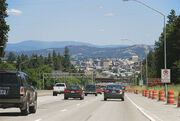
I-90 descending Sunset Hill into Spokane
Interstate 90 is the only highway in the Interstate Highway System that serves Spokane, running east−west from Seattle, through downtown Spokane, and eastward through Spokane Valley, Liberty Lake, and onward to Coeur d'Alene and then Missoula.[167] Although they are not limited access highways like I-90, US 2 and US 395 enter Spokane from the west via I-90 and continue north through Spokane via Division St. The two highways share the same route until they reach "The Y", where US 395 continues northward to Deer Park, Colville then onward to Canada, and US 2 branches off to the northeast, continuing to Mead, Newport, and Sandpoint. US 195 connects to Interstate 90 near Latah Creek and travels south through the Palouse.
Over the past decade, the Washington State Department of Transportation (WSDOT) has improved local highways to keep up with the region's growth and to try to prevent congestion problems that plague many larger cities around the country. The WSDOT is currently constructing the North Spokane Corridor. When completed, the corridor will be a 10.5-mile (16.9 km) long limited access highway that will run from I-90 in the vicinity of the Thor/Freya interchange northward through Spokane, meeting the existing US 395 just south of Wandermere Golf Course.[168]
Public transportation[]


The STA Plaza in Downtown Spokane
Before the influx of automobiles, Spokane's electric streetcar and interurban lines played a dominant role in moving people and goods around Spokane as well as influencing local and regional development patterns. Many of the older side streets in Spokane still have visible streetcar rails embedded in them, as they were never removed. Streetcar service was reduced due to declining ridership beginning in 1922, and by August 1936, all streetcar lines had been abandoned or converted to motor buses.[169]
Today, mass transportation throughout the Spokane area is provided by the Spokane Transit Authority (STA). STA currently operates approximately 156 buses and has a service area that covers roughly 248 square miles (640 km2).[170] A large percentage of STA bus routes originate from the central hub, the STA Plaza, in downtown Spokane. Passengers who stop at The Plaza can connect to nearly any other Spokane Transit route.
Intercity transportation[]
Spokane has rail and bus service provided by Amtrak and Greyhound via the Spokane Intermodal Center. The city is a stop for Amtrak's Empire Builder on its way to and from Chicago's Union Station en route to Seattle and Portland.[171] Through service is a legacy of BNSF Railway's old Spokane, Portland and Seattle Railway trackage.[172] Spokane is a major railway junction for the BNSF Railway and the Union Pacific Railroad and is the western terminus for the Montana Rail Link.[172]
Airports[]


Aerial view of Spokane looking east
Spokane, eastern Washington and northern Idaho are served by Spokane International Airport at Geiger Field (GEG). Spokane International Airport is the second largest airport in the state of Washington and is recognized by the Federal Aviation Administration as a small hub.[173] The airport is located 5 miles (8.0 km) west of downtown Spokane and is approximately a 10-minute drive away. Spokane International Airport is served by six airlines and two air cargo carriers.[173] The international airport three letter designation is "GEG", a result and legacy of the Geiger Field days prior to 1960, when the airport was named after Army aviator Major Harold Geiger in 1941.[174]
Felts Field is a general aviation airport serving the Spokane area and is located in east Spokane along the Spokane River. Felts Field served as Spokane's primary airport until commercial air traffic was redirected to Geiger Field after World War II.[174]
Utilities[]

Monroe Street Dam
The City of Spokane provides municipal water, wastewater management, and solid waste management.[175] Spokane operates Washington's only waste-to-energy plant, as well as two solid waste transfer stations in the Spokane area as part of the Spokane Regional Solid Waste System, a collaboration between the City of Spokane and Spokane County.[176] Electricity generated by the waste-to-energy plant is used to operate the facility with excess energy being sold to Puget Sound Energy.[176] Natural gas and electricity is provided by the local utility, Avista Utilities, while CenturyLink and Comcast provide television, internet, and telephone service.
Sister cities[]
Spokane has four current sister cities, as designated by Sister Cities International: [177]
 Nishinomiya, Hyōgo Prefecture, Japan – since September 1961 (Spokane's first sister city)
- Jecheon, South Korea
- Jilin City, China
- Limerick, Ireland
See also[]
- National Register of Historic Places listings in Spokane County, Washington
- People from Spokane
Notes[]
^[a] The present name, set forth by an 1891 charter reincorporated the city under the name "Spokane Falls", stating: "The corporate name of the city is Spokane Falls, and by that name shall have perpetual succession (Charter, Article I)." However, a later article in that same charter which was voted on concurrently changed the name to "Spokane".
^[b] Secretary of the Spokane chamber of commerce, John R. Reavis tells of Spokane's significance to the Inland Northwest region as a distributing center in his 1891 Annual Report, writing: "By reason of her geographical position and railroad connections Spokane is fitted as no other city is, or ever can be, to be the distributing center of all that country within a radius of 150 miles, and in some instances territory much farther away. There is no point 150 miles from Spokane that is not at least 225 miles from any other city of 10,000 population. We have about us a territory of 60,000 square miles in extent, to every point of which we are nearer than any other city, to every point of which we have better railroad connections and easier grades than any other city...We have eight lines of railroad that radiate out in all directions through it, so that shipments made here in the morning can reach any point within its borders by nightfall. We have a telephone system connecting us with almost every shipping town and shipping station within its borders. Goods may be ordered, shipped and received, in most instances, within one day. Never was a city more intimately knit to its surrounding territory than Spokane, and never was one more free from a legitimate rival in trade..." [Reavis, John R. (1892). First Annual Report of the Secretary of the Chamber of Commerce of Spokane for the Year 1891. Pacific Northwest Collections, University of Washington Libraries. Spokane, Washington: W. D. Knight. pp. 6–7, 10–12.]
^[c] The initial rebuilding came in large part from the infusion of investment from Dutch bankers. (Stratton, p. 33)
^[d] In 1892, the Interstate Commerce Commission agreed with the city after it filed a complaint about these practices, but that decision was struck down by a federal court. In 1906, Spokane sued under the newly passed Hepburn Act, and won on July 24, 1911. (Durham, pp. 599–603)
References[]
- ^ a b "US Gazetteer files 2010". United States Census Bureau. http://www.census.gov/geo/www/gazetteer/files/Gaz_places_national.txt. Retrieved December 19, 2012.
- ^ a b c d "American FactFinder". United States Census Bureau. http://factfinder2.census.gov/faces/nav/jsf/pages/index.xhtml. Retrieved December 19, 2012.
- ^ "Error: no
|title=specified when using {{Cite web}}" (CSV). 2011 Population Estimates. United States Census Bureau, Population Division. September 10, 2012. - ^ "Population Estimates". United States Census Bureau. http://www.census.gov/popest/data/cities/totals/2012/SUB-EST2012.html. Retrieved June 1, 2013.
- ^ "Zip Code Lookup". USPS. http://zip4.usps.com/zip4/citytown.jsp. Retrieved December 11, 2008.
- ^ "US Board on Geographic Names". United States Geological Survey. 2007-10-25. http://geonames.usgs.gov. Retrieved 2008-01-31.
- ^ USA: http://www.census.gov/popest/data/cities/totals/2012/index.html Canada: http://www12.statcan.gc.ca/census-recensement/2011/dp-pd/prof/index.cfm
- ^ Spokane Falls Community College: http://www.spokanefalls.edu/College/RegionalInformation.aspx?pp=true
- ^ a b Phillips (1971), pp. 134–135
- ^ a b Ruby et al. (2006), pp. 5–6
- ^ Ruby et al. (2006), pp. 34
- ^ Ruby et al. (2006), p. 35
- ^ a b c Oldham, Kit (January 23, 2003). "The North West Company establishes Spokane House in 1810". Essay 5099. HistoryLink. http://www.historylink.org/index.cfm?DisplayPage=output.cfm&file_id=5099. Retrieved December 13, 2008.
- ^ Meinig (1993), p. 69
- ^ Wilma, David (January 29, 2003). "U.S. Army Colonel George Wright hangs Yakama and Palouse prisoners at the Ned-Whauld River beginning on September 25, 1858". Essay 5141. HistoryLink. http://www.historylink.org/index.cfm?DisplayPage=output.cfm&file_id=5141. Retrieved January 2, 2009.
- ^ a b Wilma, David (January 27, 2003). "J. J. Downing and S. R. Scranton file claims and build a sawmill at Spokane Falls in May 1871". Essay 5132. HistoryLink. http://www.historylink.org/index.cfm?DisplayPage=output.cfm&file_id=5132. Retrieved January 2, 2009.
- ^ Schmeltzer (1988), p. 39
- ^ Kensel (1971), p. 19
- ^ Schmeltzer (1988), p. 40
- ^ Oldham, Kit (March 4, 2003). "U.S. Army establishes Fort Spokane at the junction of the Spokane and Columbia rivers in 1882". Essay 5358. HistoryLink. http://www.historylink.org/index.cfm?DisplayPage=output.cfm&file_id=5358. Retrieved December 16, 2008.
- ^ Wilma, David (January 28, 2003). "First train arrives at Spokane Falls on June 25, 1881". Essay 5137. HistoryLink. http://www.historylink.org/index.cfm?DisplayPage=output.cfm&file_id=5137.
- ^ a b Arksey, Laura (October 3, 2009). "Spokane Falls (later renamed Spokane) is incorporated as a first-class city on November 29, 1881". Essay 9176. HistoryLink. http://www.historylink.org/index.cfm?DisplayPage=output.cfm&file_id=9176. Retrieved December 16, 2008.
- ^ a b c Schmeltzer (1988), p. 44
- ^ Stratton (2005), pp. 29–30, 32–33
- ^ Kensel (1969), p. 85. According to the Spokane Falls Review Dec. 1, 1883 edition.
- ^ Kensel (1969), pp. 85–89
- ^ a b Arksey, Laura (March 20, 2006). "Great Spokane Fire destroys downtown Spokane Falls on August 4, 1889". Essay 7696. HistoryLink. http://www.historylink.org/index.cfm?DisplayPage=output.cfm&File_Id=7696. Retrieved December 13, 2008.
- ^ Schmeltzer (1988), pp. 42–43
- ^ a b c Kershner, Jim (December 15, 2007). "Spokane Neighborhoods: Hillyard". Essay 8406. HistoryLink. http://www.historylink.org/index.cfm?DisplayPage=output.cfm&file_id=8406%3C/ref. Retrieved December 19, 2008.
- ^ a b Stratton (2005), p. 32
- ^ a b Schmeltzer (1988), p. 41
- ^ (October 1911) "Spokane, Gateway City: Metropolis of the Inland Empire". Railway Employees Magazine and Journal 6 (1): 2.
- ^ a b Stratton (2005), p. 35
- ^ Reider, Ross (June 22, 2005). "IWW formally begins Spokane free-speech fight on November 2, 1909". Essay 7357. HistoryLink. http://www.historylink.org/index.cfm?DisplayPage=output.cfm&file_id=7357. Retrieved December 19, 2008.
- ^ a b Rayback (1966) p. 244
- ^ Stratton (2005), p. 152
- ^ a b c Kensel (1968), p. 25
- ^ Kensel (1968), pp. 28–29, 31
- ^ Durham (1912), p. 598
- ^ Stratton (2005), p. 38
- ^ Stratton (2005), pp. 211–212
- ^ Stratton (2005), p. 215
- ^ Stratton (2005), p. 207
- ^ a b Berger, Knute (November 6, 2012). "Preserving state's heritage: Why Spokane is central". Crosscut Public Media. http://crosscut.com/2012/11/06/mossback/111332/preserving-states-heritage-spokanes-importance. Retrieved April 1, 2009.
- ^ Wilma, David (January 27, 2003). "Expo 74 Spokane World's Fair opens on May 4, 1974". Essay 5133. HistoryLink. http://www.historylink.org/index.cfm?DisplayPage=output.cfm&File_Id=5133. Retrieved December 13, 2008.
- ^ Schmeltzer (1988), p. 85
- ^ a b Schmeltzer (1988), p. 87
- ^ a b c d Arksey, Laura (September 4, 2005). "Spokane – Thumbnail History". Essay 7462. HistoryLink. http://www.historylink.org/index.cfm?DisplayPage=output.cfm&File_Id=7462. Retrieved December 16, 2008.
- ^ Arksey, Laura (November 29, 2005). "Davenport Hotel (Spokane)". Essay 7545. HistoryLink. http://www.historylink.org/index.cfm?DisplayPage=output.cfm&file_id=7545. Retrieved December 16, 2008.
- ^ Kershner, Jim (July 2, 2008). "Restored Fox Theater in Spokane reopens as the Martin Woldson Theater at the Fox in a gala concert on November 17, 2007". Essay 8681. HistoryLink. http://www.historylink.org/index.cfm?DisplayPage=output.cfm&file_id=8681. Retrieved December 16, 2008.
- ^ "Calculate distance between two locations". Time and Date AS. http://www.timeanddate.com/worldclock/distance.html. Retrieved January 11, 2009.
- ^ "Inland Empire". Merriam-Webster, Incorporated. http://www.merriam-webster.com/dictionary/inland%20empire. Retrieved December 13, 2008.
- ^ a b c "Station Information Data Sheet – Spokane, Washington". National Weather Service. April 2008. http://www.wrh.noaa.gov/otx/spokane.php. Retrieved January 10, 2009.
- ^ "Draft: Level III and IV Ecoregions of the Northwestern United States" (PDF). U.S. Environmental Protection Agency. May 15, 2002. ftp://ftp.epa.gov/pub/wed/ecoregions/reg10/pnw_map.pdf. Retrieved January 10, 2009.
- ^ "Feature Detail Report for: Mount Spokane". U.S. Geological Survey. http://geonames.usgs.gov/pls/gnispublic/f?p=gnispq:3:34351196088528::NO::P3_FID:1512684. Retrieved February 4, 2009.
- ^ a b Soltero et al. (1992), p. 460
- ^ Breckenridge, Roy M. (May 1993) (PDF). Glacial Lake Missoula and the Spokane Floods (Report). GeoNotes. 26. Idaho Geological Survey. http://www.idahogeology.org/PDF/GeoNotes_(G)/geonote_26.pdf.
- ^ "NWS Spokane, WA". National Weather Service. http://forecast.weather.gov/MapClick.php?CityName=Spokane&state=WA&site=OTX&textField1=47.6589&textField2=-117.425&e=1. Retrieved February 11, 2009.
- ^ 2004 DeLorme. Delorme Topo USA 5.0 West Region (CD-ROM) (Map) (5.0 ed.).
- ^ Kottek, M.; J. Grieser, C. Beck, B. Rudolf, and F. Rubel (2006). "World Map of the Köppen-Geiger climate classification updated" (GIF). Meteorol. Z. 15 (3): 259–263. DOI:10.1127/0941-2948/2006/0130. Retrieved on September 28, 2007.
- ^ a b "Average Weather for Spokane, WA". The Weather Channel. http://www.weather.com/outlook/travel/businesstraveler/wxclimatology/monthly/graph/USWA0422?. Retrieved January 7, 2009.
- ^ a b "NowData – NOAA Online Weather Data". National Oceanic and Atmospheric Administration. http://www.nws.noaa.gov/climate/xmacis.php?wfo=otx. Retrieved February 15, 2012.
- ^ a b c "Climate of Washington" (PDF). Climates of the States, Climatography of the United States No. 60. National Weather Service. http://cdo.ncdc.noaa.gov/climatenormals/clim60/states/Clim_WA_01.pdf. Retrieved February 2, 2009.
- ^ "Average Percent Sunshine through 2009". National Climatic Data Center. http://www.ncdc.noaa.gov/oa/climate/online/ccd/pctpos.txt. Retrieved November 16, 2012.
- ^ "National Trust for Historic Preservation Announces that Spokane, Washington Will Host the 2012 National Preservation Conference". National Trust for Historic Preservation. http://www.preservationnation.org/about-us/press-center/press-releases/2009/spokane-announcement.html. Retrieved November 10, 2011.
- ^ a b "WASHINGTON – Spokane County". National Register of Historic Places. http://nationalregisterofhistoricplaces.com/wa/Spokane/state.html. Retrieved November 10, 2011.
- ^ "Spokane Neighborhood Council Map". The City of Spokane and the Office of Neighborhood Services. http://www.spokaneneighborhoods.org/map.aspx. Retrieved November 10, 2011.
- ^ "2011 City and Neighborhood Rankings". Walk Score. 2011. http://www.walkscore.com/rankings/cities/. Retrieved Aug 28, 2011.
- ^ "Seven Northwest Cities: The Smart-Growth Ranking". Sightline Institute. http://www.sightline.org/maps/charts/Sprawl-ByCity-CS07. Retrieved November 10, 2011.
- ^ Grimes, William. "Learning from I-90: The North–South Freeway's Implication for Urban Form" (PDF). Studio Cascade Community Planning and Design. http://www.studiocascade.com/sc_documents/SS-I90.pdf. Retrieved November 10, 2011.
- ^ "Spokane County, Washington". United States Census Bureau. http://quickfacts.census.gov/qfd/states/53/53063.html. Retrieved January 27, 2009.
- ^ a b Stucke, John (June 8, 2011). "Spokane, Coeur d’Alene now one statistical region". The Spokesman-Review. http://www.spokesman.com/stories/2011/jun/08/spokane-coeur-dalene-now-one-statistical-region. Retrieved January 25, 2009.
- ^ Moffatt, Riley. Population History of Western U.S. Cities & Towns, 1850–1990. Lanham, Maryland: Scarecrow, 1996, 334.
- ^ "U.S. Decennial Census". Census.gov. http://www.census.gov/prod/www/decennial.html. Retrieved June 7, 2013.
- ^ "Annual Estimates of the Resident Population: April 1, 2010 to July 1, 2012". http://www.census.gov/popest/data/cities/totals/2012/SUB-EST2012-3.html. Retrieved June 7, 2013.
- ^ "Spokane, WA MSA". Metro Area Membership Report. The Association of Religion Data Archives. 2000. http://www.thearda.com/mapsReports/reports/metro/7840_2000.asp. Retrieved January 2, 2009.
- ^ (2005) "Accounting for the Uncounted: Computing Correctives for the 2000 RCMS Data". Review of Religious Research 47. Retrieved on December 12, 2011.
- ^ Stratton (2005), p. 28
- ^ Higgs, Robert (June 2, 2004). "Coasian Contracts in the Coeur d'Alene Mining District". Working Paper #52. The Independent Institute. http://www.independent.org/publications/working_papers/article.asp?id=1337. Retrieved March 6, 2009.
- ^ Kensel (1968) p. 31
- ^ Schmeltzer (1988), p. 93
- ^ Kensel (1969), p. 91
- ^ a b Payne, Loretta; Froyalde, Revelyn (January 2001). "Spokane County Profile" (PDF). Employment Security Department, Labor Market and Economic Analysis Branch. Archived from the original on February 6, 2007. //web.archive.org/web/20070206043625/http://www.wa.gov/esd/lmea/pubs/profiles/spokane.pdf. Retrieved December 18, 2008.
- ^ "Potlatch". CNNMoney. http://money.cnn.com/magazines/fortune/fortune500/snapshots/1071.html. Retrieved November 10, 2011.
- ^ "About Us". Signature Genomic Laboratories, LLC. http://www.signaturegenomics.com/about.html. Retrieved February 6, 2009.
- ^ "Itron". CNNMoney. http://money.cnn.com/magazines/fortune/fortune500/2009/snapshots/11497.html. Retrieved November 10, 2011.
- ^ "Key Tronic Corp". CNNMoney. http://money.cnn.com/quote/quote.html?symb=KTCC. Retrieved November 10, 2011.
- ^ "Red Lion Hotels Corp". CNNMoney. http://money.cnn.com/quote/quote.html?symb=RLH. Retrieved November 10, 2011.
- ^ "Top Employers". Greater Spokane Incorporated. http://www.greaterspokane.org/business-overview/90-top-employers.html. Retrieved November 10, 2011.
- ^ "American FactFinder". United States Census Bureau. http://factfinder.census.gov. Retrieved 2008-01-31.
- ^ Tatge, Mark (April 23, 2007). "Paradise, Slightly Dry". Best Places. Forbes. http://www.forbes.com/free_forbes/2007/0423/078.html. Retrieved February 10, 2009.
- ^ Lydgate, Chris (May 2006). "The Buck Stopped Here". Inc.. http://www.inc.com/magazine/20060501/buck-stopped-here.html. Retrieved February 10, 2009.
- ^ "Spokane: Hub of the Inland Northwest" (PDF). Greater Spokane Incorporated. 2008. Archived from the original on February 6, 2010. //web.archive.org/web/20090325073918/http://www.greaterspokane.org/admin/lib/docs/pdf/spokane.pdf. Retrieved December 16, 2008.
- ^ "100 best places to live and launch". CNNMoney. July 2, 2008. http://money.cnn.com/galleries/2008/fsb/0803/gallery.best_places_to_launch.fsb/77.html. Retrieved December 13, 2008.
- ^ "Past Winners of the All-America City Award". National Civic League. http://www.allamericacityaward.com/things-to-know-about-all-america-city-award/past-winners-of-the-all-america-city-award/past-winners-of-the-all-america-city-award-1970s/. Retrieved February 22, 2009.
- ^ "About the MAC". Northwest Museum of Arts & Culture. http://northwestmuseum.org/about. Retrieved February 8, 2012.
- ^ "Northwest Museum of Arts & Culture". Smithsonian Affiliations. http://affiliations.si.edu/AffiliateDetail.Asp?AffiliateID=104. Retrieved February 8, 2009.
- ^ "Mobius". Mobius Spokane. http://www.mobiusspokane.org. Retrieved February 8, 2013.
- ^ "Spokane honors most famous hometowner Bing Crosby by naming theater after him". International Herald Tribune. Associated Press. December 7, 2006. http://www.iht.com/articles/ap/2006/12/07/arts/NA_A-E_CEL_US_Bing_Crosby_Theater.php. Retrieved January 5, 2009.
- ^ Crane, Julianne (April 1, 2004). "Take a walk for the arts". The Spokesman-Review. http://www.spokesmanreview.com/pf.asp?date=040104&ID=s1504786. Retrieved January 25, 2009.
- ^ "First Friday". Downtown Spokane Partnership. http://www.downtownspokane.org/first-friday.php. Retrieved February 19, 2009.
- ^ "Spokane All Ages Music Initiative". The Spovangelist. http://spovangelist.com/spokane-all-ages-music-initiative/. Retrieved November 10, 2011.
- ^ "About SSO". Spokane Symphony. http://www.spokanesymphony.org/16,aboutsso. Retrieved January 25, 2009.
- ^ "SJO History". Spokane Jazz Orchestra. http://www.spokanejazz.org/about-sjo/sjo-history. Retrieved January 25, 2009.
- ^ "About Interplayers". Interplayers Ensemble. http://www.interplayers.com/about/. Retrieved January 24, 2009.
- ^ Kershner, Jim (July 18, 2007). "Olmsted Parks in Spokane". Essay 8218. HistoryLink. http://historylink.org/index.cfm?DisplayPage=output.cfm&file_id=8218. Retrieved January 6, 2009.
- ^ Schmeltzer (1988), pp. 64–65
- ^ Arksey, Laura (April 5, 2010). "Spokane Board of Park Commissioners begins its duties on June 1, 1907". Essay 9387. HistoryLink. http://www.historylink.org/index.cfm?DisplayPage=output.cfm&file_id=9387. Retrieved December 16, 2008.
- ^ "Parks". City of Spokane Parks & Recreation. http://spokaneparks.org/index.php/Parks/page/77/. Retrieved January 27, 2012.
- ^ a b c "History, Arts & Culture". Riverfront Park. http://spokaneriverfrontpark.com/index.php/RFP/page/387/. Retrieved January 25, 2009.
- ^ "Overview Map". Friends of the Centennial Trail. http://www.spokanecentennialtrail.org/Page/Overview-Map.aspx. Retrieved January 6, 2009.
- ^ Patterson, Caroline (June 2006). "Idaho's Lake Country". Vol. 216, No. 6. Sunset. http://www.sunset.com/travel/northwest/idahos-lake-country-00400000015398/. Retrieved April 21, 2012.
- ^ "Silverwood Theme Park". Silverwood & Boulder Beach. http://www.silverwoodthemepark.com. Retrieved January 6, 2009.
- ^ "Mount Spokane". Washington State Parks. http://www.parks.wa.gov/parks/?selectedpark=Mount+Spokane&pageno=1. Retrieved February 4, 2009.
- ^ Arksey, Laura (August 2, 2006). "Mount Spokane State Park". Essay 7819. HistoryLink. http://www.historylink.org/index.cfm?DisplayPage=output.cfm&file_id=7819. Retrieved December 19, 2008.
- ^ "History". Lilac Bloomsday Association. http://www.bloomsdayrun.org/history-stats/history. Retrieved March 13, 2009.
- ^ "A History: 1990–present". Spokane Hoopfest Association. http://www.spokanehoopfest.net/organization/Pages/history.aspx. Retrieved December 14, 2008.
- ^ "Lilac Festival". Spokane Lilac Festival Association. http://www.spokanelilacfestival.org/index.html. Retrieved March 29, 2009.
- ^ Kiddo, Linda (February 2004). "History of the Spokane Lilac Festival". Spokane Lilac Festival. Archived from the original on April 24, 2008. //web.archive.org/web/20080424001505/http://www.spokanelilacfestival.org/history.html. Retrieved December 15, 2008.
- ^ "Spokane Interstate Fair". Fair and Expo Center. http://www.spokanecounty.org/fair/. Retrieved March 29, 2009.
- ^ "Japan Week Spokane". Japan Week Spokane. http://www.japanweekspokane.com/. Retrieved March 5, 2009.
- ^ "Recreation & Sports". Experience Spokane. http://www.experiencespokane.com/sports/. Retrieved January 25, 2009.
- ^ Knight, Stephen (May 8, 1998). "1998 Memorial Cup Notebook". Canoe Inc.. http://www.canoe.ca/MemorialCup98/may17_memnotes_smk.html. Retrieved January 8, 2009.
- ^ "2002 Smart Ones Skate America". U.S. Figure Skating. October 27, 2002. http://www.usfigureskating.org/event_details.asp?id=25110. Retrieved January 24, 2009.
- ^ a b "Spokane, Wash., Selected to Host 2010 U.S. Figure Skating Championships". U.S. Figure Skating. May 5, 2008. http://www.usfigureskating.org/Story.asp?id=41450. Retrieved January 7, 2009.
- ^ "2007 State Farm U.S. Figure Skating Championships named "Sports Event of the Year"". KHQ (WorldNow and KHQ). October 27, 2007. http://www.khq.com/global/story.asp?s=7272961. Retrieved December 15, 2008.
- ^ "Spokesman-Review.com". The Spokesman-Review. http://www.spokesmanreview.com/. Retrieved January 25, 2009.
- ^ "The Pacific Northwest Inlander". INLANDER. http://www.inlander.com/spokane/. Retrieved January 25, 2009.
- ^ "Spokane Journal of Business". Journal Of Business. http://www.spokanejournal.com/. Retrieved January 25, 2009.
- ^ "Arbitron Radio Market Rankings: Winter 2012". February 2, 2012. http://www.arbitron.com/home/mm001050.asp. Retrieved December 14, 2011.
- ^ "Radio-Locator". Theodric Technologies. http://www.radio-locator.com/cgi-bin/locate?select=city&city=Spokane&state=WA. Retrieved December 18, 2011.
- ^ "Nielsen 2011–2012 TV Household DMA Ranks" (PDF). Nielsen Media Research, Inc.. September 24, 2011. http://www.tvb.org/media/file/TVB_Market_Profiles_Nielsen_Household_DMA_RANKS.pdf. Retrieved December 18, 2011.
- ^ a b "Station Index". Station Index. http://www.stationindex.com/tv/markets/Spokane. Retrieved December 18, 2011.
- ^ http://spokanetvhistory.wordpress.com/1953/11/30/radio-and-tv-outlets-sold-by-station-kxly/
- ^ http://spokanetvhistory.wordpress.com/page/16/
- ^ "City Government". City of Spokane. http://www.spokanecity.org/government/. Retrieved March 13, 2009.
- ^ "Council". City of Spokane. http://www.spokanecity.org/government/citycouncil/. Retrieved December 13, 2008.
- ^ "Spokane Government". City of Spokane. http://www.spokanecity.org/services/about/spokane/government/default.aspx?Tab=Government. Retrieved December 13, 2008.
- ^ Brunt, Jonathan (November 10, 2011). "It’s now Spokane Mayor-Elect Condon". The Spokesman-Review. http://www.spokesman.com/stories/2011/nov/10/its-now-spokane-mayor-elect-condon. Retrieved December 13, 2012.
- ^ "About Counties: Washington". National Organization of Counties. http://www.naco.org/Counties/Pages/FindACounty.aspx. Retrieved March 25, 2009.
- ^ Kershner, Jim (August 11, 2007). "Armed Cheney citizens forcibly remove the county seat from Spokane Falls to Cheney on March 21, 1881". Essay 8249. HistoryLink. http://www.historylink.org/index.cfm?DisplayPage=output.cfm&file_id=8249. Retrieved March 4, 2009.
- ^ "Jay Inslee". Office of the Governor. http://www.governor.wa.gov. Retrieved December 13, 2012.
- ^ a b "Find Your Legislator". Washington State Legislature. http://app.leg.wa.gov/DistrictFinder. Retrieved March 4, 2013.
- ^ a b "2012 Presidential Election: Washington". Politico. November 29, 2012. http://www.politico.com/2012-election/map/#/President/2012/WA. Retrieved December 13, 2012.
- ^ Oldham, Kit (August 19, 2003). "George Nethercutt, running on term limit pledge, defeats House Speaker Tom Foley on November 8, 1994". Essay 5517. HistoryLink. http://www.historylink.org/index.cfm?DisplayPage=output.cfm&File_Id=5517. Retrieved January 6, 2009.
- ^ Schmeltzer (1988), p. 71
- ^ Kershner, Jim (November 30, 2008). "Chase, James E. (1914–1987)". Essay 8788. HistoryLink. http://www.historylink.org/index.cfm?DisplayPage=output.cfm&file_id=8788. Retrieved March 4, 2009.
- ^ "Statistical Analysis Center". Uniform Crime Report. Washington State Office of Financial Management. http://wa-state-ofm.us/UniformCrimeReport/. Retrieved December 13, 2011.
- ^ a b c "Crime rates for Spokane, WA". NeighborhoodScout. http://www.neighborhoodscout.com/wa/spokane/crime. Retrieved December 13, 2012.
- ^ a b Cuniff, Meghann (March 31, 2012). "Property crimes to get new focus". The Spokesman-Review. http://www.spokesman.com/stories/2012/mar/31/property-crimes-to-get-new-focus/. Retrieved December 13, 2012.
- ^ "Branch Locations and Hours". Spokane Public Libraries. http://spokanelibrary.org/index.php?page=branches. Retrieved January 25, 2009.
- ^ "Spokane Public Library" (PDF). Spokane Public Libraries. http://www.spokanelibrary.org/admin/uploads/files/Policies/special_collection_seating.pdf. Retrieved January 25, 2009.
- ^ "District Profile". Spokane Public Schools. http://www.spokaneschools.org/Page/54. Retrieved January 6, 2009.
- ^ http://www.mead354.org/uploaded/District_Office/About_Us/documents/mead_district_secondary_map.pdf
- ^ http://www.spokaneneighborhoods.org/map.aspx
- ^ "Catholic Schools, Diocese of Spokane". Catholic Diocese of Spokane. http://www.dioceseofspokane.org/find_school.php. Retrieved January 6, 2009.
- ^ Kershner, Jim (February 21, 2007). "Gonzaga University". Essay 8097. HistoryLink. http://www.historylink.org/index.cfm?DisplayPage=output.cfm&file_id=8097. Retrieved December 16, 2008.
- ^ Arksey, Laura (April 21, 2007). "Whitworth College". Essay 8125. HistoryLink. http://www.historylink.org/index.cfm?DisplayPage=output.cfm&file_id=8125. Retrieved December 16, 2008.
- ^ "WSU Spokane". Washington State University. http://spokane.wsu.edu. Retrieved January 26, 2012.
- ^ "EWU Spokane". Eastern Washington University. http://www.ewu.edu/locations/riverpoint-campus.xml. Retrieved January 26, 2012.
- ^ "Health Sciences". Washington State University. http://spokane.wsu.edu/HealthSciences/index.html. Retrieved November 10, 2011.
- ^ "Mukogawa Fort Wright Institute". Mukogawa Fort Wright Institute. http://www.mfwi.edu/. Retrieved November 10, 2011.
- ^ "Hospital Directory". Healthgrades. http://www.healthgrades.com/hospital-directory/wa-washington/spokane. Retrieved December 18, 2011.
- ^ "Locations". Shriners International & Shriners Hospitals for Children. http://www.shrinershospitalsforchildren.org/en/Hospitals/Locations.aspx. Retrieved February 1, 2009.
- ^ Kershner, Jim (October 18, 2012). "Medical Lake -- Thumbnail History". Essay 10231. HistoryLink. http://www.historylink.org/index.cfm?DisplayPage=output.cfm&file_id=10231. Retrieved December 16, 2008.
- ^ "Traffic Flow Maps". City of Spokane. http://www.spokanestreetdepartment.org/flowmaps.htm. Retrieved March 31, 2011.
- ^ Washington State Department of Transportation (2008). Official State Highway Map (Map). 1:842,000. Official State Highway Maps. Cartography by U.S. Geological Survey (2008–2009 ed.). http://www.wsdot.wa.gov/NR/rdonlyres/87105CAD-83A9-49A7-80F3-5719637C1E2D/0/FrontMapBig.pdf. Retrieved March 13, 2009.
- ^ "North Spokane Corridor Quick Facts". Washington State Department of Transportation. http://www.wsdot.wa.gov/Projects/US395/NorthSpokaneCorridor/Facts.htm. Retrieved December 23, 2008.
- ^ Kershner, Jim (January 25, 2007). "Spokane's Streetcars". Essay 8080. HistoryLink. http://www.historylink.org/index.cfm?DisplayPage=output.cfm&file_id=8080. Retrieved March 5, 2009.
- ^ "Frequently Asked Questions". Spokane Transit. http://www.spokanetransit.com/about-sta/view/faq-frequently-asked-questions/. Retrieved January 24, 2012.
- ^ "Amtrak Stations – Spokane, WA (SPK)". National Railroad Passenger Corporation. http://www.amtrak.com/servlet/ContentServer?pagename=am/am2Station/Station_Page&code=SPK. Retrieved January 16, 2011.
- ^ a b "Hot Spots: Spokane, Wash.". Trains. http://trn.trains.com/en/Railroad%20Reference/Hot%20Spots/2006/07/Spokane%20Wash.aspx. Retrieved December 14, 2008.
- ^ a b "Spokane International Airport". Spokane International Airport. http://www.spokaneairports.net/. Retrieved December 13, 2008.
- ^ a b Arksey, Laura (January 15, 2008). "Felts Field (Spokane)". Essay 8464. HistoryLink. http://www.historylink.org/index.cfm?DisplayPage=output.cfm&file_id=8464. Retrieved December 19, 2008.
- ^ "The Spokane Regional Solid Waste System". Spokane Regional Solid Waste System. http://www.solidwaste.org/. Retrieved April 1, 2009.
- ^ a b Roesler, Richard (February 25, 2009). "Plant's electricity could gain value with ‘renewable’ status" (Reprint). Spokesman-Review. http://www.spokesman.com/stories/2009/feb/25/from-garbage-to-green/. Retrieved April 1, 2009.
- ^ "Sister Cities Association of Spokane". Spokane Sister Cities Association. http://www.spokanesistercities.org/. Retrieved November 10, 2011.
Bibliography[]
- Durham, Nelson W. (1912). History of the city of Spokane and Spokane County, Washington: from its earliest settlement to the present time. 3. S.J. Clarke Pub. Co.. ISBN 978-1-152-77997-6. http://books.google.com/books?id=M4EUAAAAYAAJ.
- Kensel, W.H. (Spring 1968). "The Early Spokane Lumber Industry, 1871–1910". Idaho Yesterdays 12 (1).
- Kensel, W.H. (April 1969). "Inland Empire Mining and the Growth of Spokane, 1883–1905". Pacific Northwest Quarterly 60 (2).
- Kensel, W.H. (Spring 1971). "Spokane: The First Decade". Idaho Yesterdays 15 (1).
- Meinig, Donald W. (1993). The Shaping of America: A Geographical Perspective on 500 Years of History, Volume 2: Continental America, 1800–1867. Yale University Press. ISBN 0-300-05658-3.
- Phillips, James W. (1971). Washington State Place Names. University of Washington Press. ISBN 0-295-95158-3.
- Rayback, Joseph G. (1966). A History of American Labor. Free Press. ISBN 978-0-02-925850-7. http://books.google.com/books?id=i9Tk_WF9Hc4C.
- Ruby, Robert H.; John A. Brown (2006). The Spokane Indians: Children of the Sun. University of Oklahoma Press. ISBN 0-8061-3761-4, 9780806137612. http://books.google.com/books?id=qUwYm6e8UxgC&pg.
- Schmeltzer, Michael (1988). Spokane: The City and The People. American Geographic Publishing. ISBN 0-938314-53-X.
- Soltero, Raymond A. (1992). "The Changing Spokane River Watershed". In Robert J. Naiman. Watershed Management: Balancing Sustainability and Environmental Change. Springer. pp. 458–478. ISBN 978-0-387-94232-2. http://books.google.com/books?id=tkLRW9KMzhsC&pg=PA459.
- Stratton, David H. (2005). Spokane and the Inland Empire: An Interior Pacific Northwest Anthology. Pullman, Washington: Washington State University Press. ISBN 978-0-87422-277-7.
Further reading[]
- Edwards, Jonathan; Nelson Durham (1900) (DJVU). Illustrated history of Spokane county. Washington State Library's Classics in Washington History collection. Spokane, Washington: W.H. Lever. ISBN 9781153386357. OCLC 25321986. http://www.secstate.wa.gov/history/publications_view.aspx?pub=100&p=314&i=images/publications/SL_edwardsillustrated/directory.djvu.
- MacGibbon, Elma (1904). "Spokane and the Inland Empire" (DJVU). Leaves of knowledge. Washington State Library's Classics in Washington History collection. Spokane, Washington: Shaw & Borden. ISBN 978-1110684991. OCLC 61326250. http://www.secstate.wa.gov/history/publications%5Fdetail.aspx?p=63.
- Popejoy, Don; Penny Hutten (2010). Early Spokane. Images of America. Charleston, South Carolina: Arcadia Publishing. ISBN 978-0-7385-8145-3. OCLC 648936401. http://books.google.com/books?id=N6Yte06lUOQC.
- Wang, David (2003). Sounding Spokane: perspectives on the built environment of a regional city. Spokane, Washington: Eastern Washington University Press. ISBN 978-0-910055-85-7. OCLC 51306066.
External links[]
| Find more about Spokane on Wikipedia's sister projects: |
| Definitions from Wiktionary | |
| Textbooks from Wikibooks | |
| Quotations from Wikiquote | |
| Source texts from Wikisource | |
| Images and media from Commons | |
| News stories from Wikinews | |
| Learning resources from Wikiversity |
- City of Spokane Official Website
- Spokane Regional Convention and Visitors Bureau
- Greater Spokane Incorporated, Spokane Chamber of commerce
- Historylink.org, Online encyclopedia of Washington state history
- Spokane, Washington at the Open Directory Project
- Spokane travel guide from Wikivoyage
- The Spokesman-Review
| ||||||||||||||||||||

| |||||||||||||||||||||||||||||||||||||||||
Template:Washington cities and mayors of 100,000 population
| This page uses content from the English language Wikipedia. The original content was at Spokane, Washington. The list of authors can be seen in the page history. As with this Familypedia wiki, the content of Wikipedia is available under the Creative Commons License. |