| Main | Births etc |
|---|
| Lane Cove Sydney, | |||||||||||||
 Lane Cove pedestrian plaza, facing east | |||||||||||||
| Population: | 9,080 (2006)[1] | ||||||||||||
| Postcode: | 2066 | ||||||||||||
| Area: | 2.5 km² (1.0 sq mi) | ||||||||||||
| Property Value: | AUD $880,000 (2009) | ||||||||||||
| Location: | 9 km (6 mi) north-west of Sydney CBD | ||||||||||||
| LGA: | Municipality of Lane Cove | ||||||||||||
| State District: | Lane Cove, Willoughby | ||||||||||||
| Federal Division: | North Sydney | ||||||||||||
| |||||||||||||
Lane Cove is a suburb on the lower North Shore of Sydney, in the state of New South Wales, Australia. Lane Cove is located 9 kilometres north-west of the Sydney central business district and is the administrative centre for the local government area of the Municipality of Lane Cove. Lane Cove West and Lane Cove North are separate suburbs.
Lane Cove occupies a peninsula on the northern side of Port Jackson (Sydney Harbour), at the opening of the Lane Cove River.
History[]
There are a number of possibilities of the origin of the name 'Lane Cove'. The first written use of the name was by Lieutenant William Bradley after he had just sailed along the river in 1788. Some have argued that the it was named after Lieutenant Michael Lane, a respected cartographer, who had once worked with Captain Cook. Others say that it was in honour of John Lane, who was the son of the London Lord Mayor at the time as well as a good friend of the first Governor, Arthur Phillip. In any case, the name stuck, and by the 1800s was being used to refer to all the land north of the river.
Aboriginal culture[]
Prior to the arrival of the First Fleet, the area in which Lane Cove is situated was inhabited by the Cam-mer-ray-gal Group of the Ku-ring-gai Aboriginal Tribe. The group, which inhabited the north shore of Port Jackson, was one of the largest in the Sydney area.[2]
European settlement[]
Lieutenant Ralph Clark was the first European to land, a short distance from the entrance to the Lane Cove River on 14 February 1790. There were land grants in 1794 to some privates and non-commissioned officers in the New South Wales Corps, although few of these grants were actually settled as the steep, timbered land was not particularly habitable. However, Lane Cove was an excellent source for timber and other commodities that the settlers required. During the 19th century, farms and dairies were also established. There were also many industrial and manufacturing factories constructed around Greenwich.
Most of the residential growth in the area however occurred after World War II when returning soldiers were granted blocks of land around Lane Cove. The land value, which was relatively cheap during this time, surged during the 1980s and 1990s when the water views, large suburban blocks, ease of transport and quiet streets became popular.[3]


Commercial area[]


Lane Cove Town Hall
Although Lane Cove is primarily a residential area, it contains some commercial and light industrial areas.
Lane Cove has a shopping centre that includes a pedestrian plaza at the eastern end of Burns Bay Road, where it meets Longueville Road. There is a Coles supermarket and a number of small specialty stores in this area, as well as a large number of restaurants and cafes. At the end of Longueville Road is the Longueville Hotel, which is the only pub in the suburb.
Several large businesses are located in Lane Cove including poker machine manufacturing company Aristocrat Leisure Limited, the Australian headquarters of statistical software company SAS, the recording house for Warner Bros., Festival Mushroom Records, and the headquarters of hearing implant developer and manufacturer Cochlear Limited.
Lane Cove Library[]
Lane Cove Library is operated by the council and is a member of the Shorelink Library Network, allowing residents to borrow books from libraries throughout the Lower North Shore. Council passed a vote in late 2004 for a major shopping retailer to redevelop parts of Lane Cove, which would also require the construction of a new library. After 2 years in the Land and Environment Court, the new library project in conjunction with the new Woolworths shopping centre project commenced early in 2008. The Lane Cove Library re-opened in its new, renovated location in March, 2010.
Lane Cove Aquatic Centre[]
Lane Cove Aquatic centre contains a 50 metre swimming pool, a 25 metre swimming pool, a shallow pool for toddlers and young children and a well equipped gym. There are also water springs, a sauna, spa and a kiosk.
")
")
")
")
Transport[]
The Gore Hill Freeway, which brings traffic from the city, the airport and southern suburbs connects to two major roads at Lane Cove - the Pacific Highway which travels north and Epping Road which goes north-west. The traffic problems at these intersections led to the construction of the Lane Cove Tunnel, which takes vehicles straight from the Gore Hill Expressway to the M2. Cars can now travel from the Baulkham Hills Shire to the airport without having to pass a single set of traffic lights (although there are tolls to pay in each direction). Since the opening of the Lane Cove Tunnel, two lanes of Epping Road between Mowbray Road and Lane Cove have been removed, with the left lane in each direction becoming a Bus Lane, reducing Epping Road in some sections to one lane in each direction for general traffic.
Lane Cove was the terminus of one of Sydney's northern tram lines, which closed in the late 1950s. Trams operated to Wynyard in the city and Balmoral via Crows Nest. The current 254 bus route largely follows the city route from Longueville Road to Wynyard via Crows Nest and North Sydney. The 140 bus route From Manly to Epping follows a large section of the old Balmoral route. A new major bus interchange constructed at the intersection of Epping Road and Longueville Road, as part of the Lane Cove tunnel works, opened in March 2008 with approximately 25 separate bus routes (including school routes) operating from here. This provides connections to north-west Sydney with services to Pennant Hills and Rouse Hill operated by HillsBus, and publicly operated services to Chatswood, Epping, North Sydney, Manly, Gladesville and Drummoyne. City (QVB) Express services are extremely busy during morning peak. [4]
A new cyclepath along the southern edge of Epping Road from the Pacific Highway to the Lane Cove River is under construction. This will provide a link to the Gore Hill Freeway Cyclepath which will connect Chatswood, North Sydney, Willoughby to the Macquarie Park area.
A ferry service that travels someway down the Lane Cove River, stops at Longueville Wharf and Greenwich Wharf.
The closest train stations are quite a distance away at Chatswood, Artarmon and St Leonards. It is not surprising that according to the 2001 census, only 4.1% of the population travelled to work by train alone. Other ways to travel include the train and bus (1.7%), walking or cycling (5.9%), the bus only (14.3%) and car (71.0%).
Education[]
- Currambena School
- Lane Cove Public School - a primary school, established in 1876, that educates around 800 students.
- St Michael's School
Parks[]

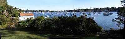
Woodford Bay, Lane Cove River
Around 16% of the area is devoted to public recreational areas including Burns Bay Park, Tambourine Bay Park, Pottery Green, Blackman Park and Tantallon Oval. As well as this there is a large amount of bushland surrounding the river's edge especially near Riverview and Lane Cove West. Lane Cove also has many small creeks and rivers that flow through it and therefore has many expanses of bushland. The Lane Cove River is the largest river in the area. Lane Cove National Park is located close to the suburb. The Lane Cove Bushland Park is home to an endangered species of fungus, Hygrocybe lanecovensis, which is found nowhere else.[5] The species was discovered in the 1990s.
Demographics[]
According to the 2006 census, the population numbered 9,080 of which 4,225 were males (46.5%) and 4,855 were females (53.5%).[1]
Notable residents[]
- Robert Dessaix's autobiography, A Mother's Disgrace, contains a memoir of growing up in Lane Cove in the 1950s.
- Brett Whiteley, artist, during his youth and painted the trees outside his bedroom window.
- Brett Lee, Australian cricketer.
- Sam Newman, Australian.
References[]
- ^ a b "2006 Census Community Profile Series : Lane Cove (State Suburb)". Australian Bureau of Statistics. Accessed 14 October 2009.
- ^ "A Brief History of Lane Cove". About the area. Lane Cove Council. http://www.lanecove.nsw.gov.au/About%20the%20Area/History%20and%20Profile/History/History.htm. Retrieved 2007-10-29.
- ^ The Book of Sydney Suburbs, Frances Pollon, Angus & Robertson Publishers, 1990, p.146 ISBN 0-207-14495-8, page 146
- ^ "Your Guide to Bus Services at lane Cove Interchange". About the area. NSW Department of Transport. http://www.transport.nsw.gov.au/news/Lane-Cove-Interchange.pdf. Retrieved 2008-04-20.
- ^ NSW threatened species: Hygrocybe lanecovensis
External links[]
- Lane Cove, New South Wales is at coordinates Coordinates:
- Lane Cove at the Open Directory Project
- Lane Cove Council
- Lane Cove Bushland Wiki
| |||||||||||
| This page uses content from the English language Wikipedia. The original content was at Lane Cove, New South Wales. The list of authors can be seen in the page history. As with this Familypedia wiki, the content of Wikipedia is available under the Creative Commons License. |