| Main | Births etc |
|---|
| Blackheath | |
 All Saints' Church |
|
Blackheath | |
| Population | 26,914 (2011 Census. Lewisham Ward: 14,039)[1] (2011 Census. Blackheath Westcombe Ward: 12,875)[2] |
|---|---|
| OS grid reference | |
| - Charing Cross | 6.7 mi (10.8 km) WNW |
| London borough | Greenwich |
| Lewisham | |
| Ceremonial county | Greater London |
| Region | London |
| Country | England |
| Sovereign state | United Kingdom |
| Post town | LONDON |
| Postcode district | SE3, SE12, SE13 |
| Dialling code | 020 |
| Police | Metropolitan |
| Fire | London |
| Ambulance | London |
| EU Parliament | London |
| UK Parliament | Lewisham East |
| Greenwich and Woolwich | |
| Eltham | |
| London Assembly | Greenwich and Lewisham |
| List of places: UK • England • London | |
Blackheath is a district of south-east London, England, straddling the Royal Borough of Greenwich and the London Borough of Lewisham.[3] It has borders with parts of London hubs Lewisham and Greenwich and other borders with Lee, Kidbrooke and a small part of Deptford.
The area south-west of its station and in its ward is named Lee Park. Its northern neighbourhood of Vanbrugh Park is also known as St John's Blackheath and despite forming a projection has amenities beyond its traditional reach named after the heath. To its west is the core public green area that is the heath and Greenwich Park, in which sit major London tourist attractions including the Greenwich Observatory and Greenwich Prime Meridian. Blackheath railway station is south of the heath.
History
Etymology
- Records and meanings
The name is from Old English spoken words 'blæc' and 'hǣth'. The name is recorded in 1166 as Blachehedfeld which means "dark,[4] or black heath field" — field denotes an enclosure or clearing but however transcribed, qualified the barren meaning of heath or stone just as Stainfield was in the Domesday Book recorded as Stain and Stainf[i]eld.[5] Lewis's topological dictionary opines, considering the adjective developed equally into derived term bleak, that Blackheath "takes its name either from the colour of the soil, or from the bleakness of its situation" before adding, reflecting Victorian appreciation, mention of "numerous villas with which it now abounds...it is pleasantly situated on elevated ground, commanding diversified and extensive views of the surrounding country, which is richly cultivated, and abounds with fine scenery".[6] It was an upland, open space that was the meeting place of the hundred of Blackheath.[4]
- Formal name for estates around the heath
By 1848 Blackheath was noted as a place with two dependent chapels under Lewisham vestry and another erected 1828-1830 designed by George Smith. The latter made use of £4000 plus land from land developer John Cator,[7] plus a further £11,000 from elsewhere.[6] The name of Blackheath gained independent official boundaries by the founding of an Anglican parish in 1854, then others (in 1859, 1883 and 1886) which reflected considerable housing built on nearby land.[8][9][10][11] In local government, Blackheath never saw independence;[12][13] at first split between the Lewisham, Lee, Charlton and Greenwich vestries or civil parish councils and Kidbrooke liberty,[14] which assembled into Greenwich, Plumstead (in final years called Lee) and Lewisham Districts then re-assembled with others into Greenwich and Lewisham metropolitan boroughs in 1900.[12]
- Etymological myth
An urban myth is Blackheath could derive from the 1665 Plague or the Black Death of the mid-14th century. A local burial pit is nonetheless likely during the Black Death, given the established village and safe harbour (hithe) status of Greenwich. At those times the extent of mortality meant that churchyard burial widely became unwieldy.
Archaeology
A key Celtic trackway (becoming a Roman road and later Watling Street) scaled the rise that is shared with Greenwich Park and a peak 1 mile (1.6 km) east-by-southeast, Shooters Hill. In the west this traversed the mouth of Deptford Creek (the River Ravensbourne) (a corruption or throwback to earlier pronunciation of deep ford).[15][16] Other finds can be linked to passing trade connected with royal palaces. In 1710, several Roman urns were dug up, two of which were of fine red clay, one of a spherical, and the other of a cylindrical, form; and in 1803, several more were discovered in the gardens of the Earl of Dartmouth and given to the British Museum.[6]
Royal setting


The Pagoda, built 1760
Certain monarchs passed through and their senior courtiers kept residences here and in Greenwich. Before the Tudor-built Greenwich Palace and Stuart-built Queen's House, one of the most frequently used was Eltham Palace about 2.5 miles (4.0 km) to the southeast of the ridge, under the late Plantagenets, before cessation as a royal residence in the 16th century.
On the north side of the heath, Ranger's House, a medium-sized red brick Georgian mansion in the Palladian style, backs directly onto Greenwich Park. Associated with the Ranger of Greenwich Park, a royal appointment, the house was the Ranger's official residence for most of the 19th century (neighbouring Montagu House, demolished in 1815, was a royal residence of Caroline of Brunswick). Since 2002, Ranger's House has housed the Wernher Collection of art.
The Pagoda is a notably exquisite home, built in 1760 by Sir William Chambers in the style of a traditional Chinese pagoda. It was later leased to the Prince Regent, principally used as a summer home by Caroline of Brunswick.
Meeting point

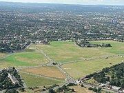
An aerial view of the heath looking south with All Saints' Church in the centre rear of the heath
Blackheath was a rallying point for Wat Tyler's Peasants' Revolt of 1381, and for Jack Cade's Kentish rebellion in 1450 (both recalled by road names on the west side of the heath). After camping at Blackheath, Cornish rebels were defeated at the foot of the west slope in the Battle of Deptford Bridge (sometimes called the Battle of Blackheath) on 17 June 1497.
In 1400, Henry IV of England met here with Byzantine Emperor Manuel II Palaiologos who toured western royalty to seek support to oppose Bayezid I (Bajazet), Ottoman Sultan. In 1415, the lord mayor and aldermen of London, in their robes of state, attended by 400 of the principal citizens, clothed in scarlet, came hither in procession to meet Henry V of England on a triumphant return from the Battle of Agincourt.[6]
Blackheath was, along with Hounslow Heath, a common assembly point for Army forces, such as in 1673 when the Blackheath Army was assembled under Marshal Schomberg to serve in the Third Anglo-Dutch War.
With Watling Street carrying stagecoaches across the heath, en route to north Kent and the Channel ports, it was also a notorious haunt of highwaymen during the 17th and 18th centuries. As reported in Edward Walford's Old and New London (1878), "In past times it was planted with gibbets, on which the bleaching bones of men who had dared to ask for some extension of liberty, or who doubted the infallibility of kings, were left year after year to dangle in the wind."[17] In 1909 Blackheath had a local branch of the London Society for Women's Suffrage.[18]
Mineral extraction
The Vanbrugh Pits are on the north-east of the heath. The site of old gravel workings,[19] they have long been reclaimed by nature and form a feature in its near-flat expanse; particularly attractive in spring when its gorse blossoms brightly.[20]
Vanbrugh Park
The remains of the pits and adjoining neighbourhood Vanbrugh Park, a north-east projection of Blackheath with its own church, so also termed St John's Blackheath,[21] are named after Sir John Vanbrugh, architect of Blenheim Palace and Castle Howard, who had a house with very large grounds adjoining the heath and its continuation Greenwich Park. The house remains, remodelled slightly, Vanbrugh Castle. In his estate he had 'Mince Pie House' built for his family, which survived until 1911.[22]
Its church, St John the Evangelist's, was designed in 1853 by Arthur Ashpitel.[23] The Blackheath High School buildings on Vanbrugh Park include the Church Army Chapel.
Blackheath Park


A map showing the Blackheath ward of Lewisham Metropolitan Borough as it appeared in 1916.
Blackheath Park (mainly opulent housing) and 1930s houses with gardens occupies almost all of former 0.4-square-mile (1.0 km2) Wricklemarsh Manor.[24] Developed into upper middle class homes by John Cator it forms the south-east of Blackheath: from Lee Road, Roque Lane, Fulthorp Road and the Plantation to all houses and gardens of right-angled Manor Way. Built up in the late 18th and early 19th centuries, it contains large and refined Georgian and Victorian houses – particularly Michael Searles' crescent of semi-detached/terrace houses linked by colonnades, The Paragon (c. 1793-1807)[25] Its alternate name, the Cator Estate, extends to lands earlier those of Sir John Morden, whose Morden College (1695) is a landmark in the north, with views of the heath. The estate has 1960s Span houses and flats with gardens with discreet parking.
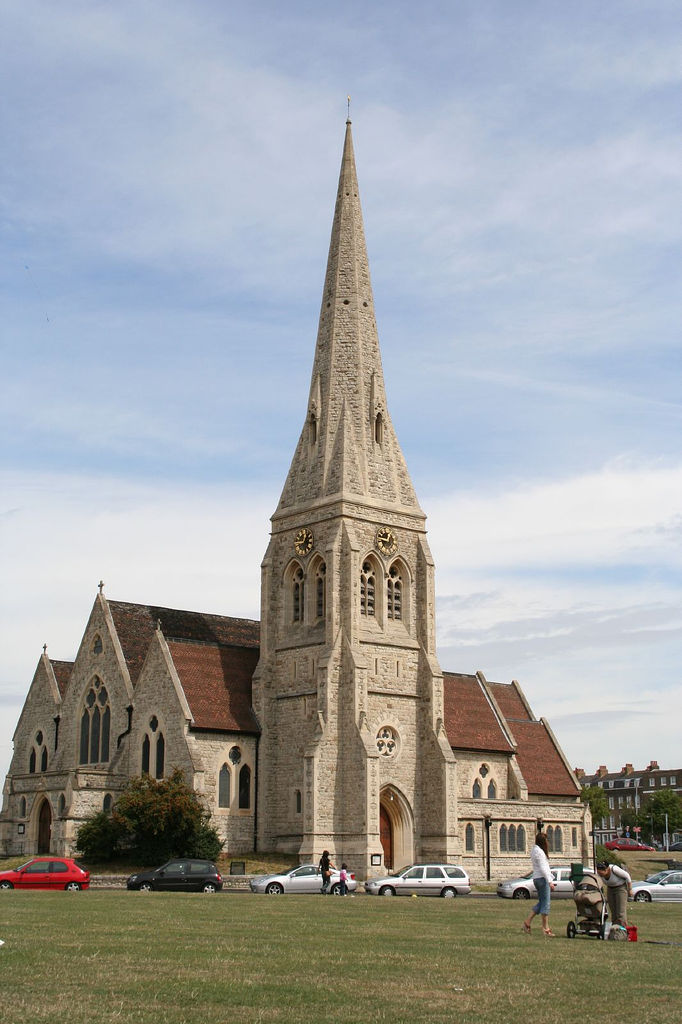
Its church dubbed the Needle of Kent in honour of its tall, thin spire (it is also nicknamed the Devil's Pick or the Devil's Toothpick). All Saints' Church, on the heath, designed by the architect Benjamin Ferrey, dates from 1857.
Other churches


Spencer House and Percival House in The Ascension part of Blackheath
The Church of the Ascension (see local II* listed buildings) was founded by Susannah Graham late in the 17th century.[26] Its rebuilding was arranged about 1750 by her descendant, the 1st Earl of Dartmouth.[26] Further rebuilding took place in the 1830s leaving at least parts of the east end from the earlier rebuild. At this time galleries for worshippers overlooked three sides.[26]
Ownership and management of the heath
In 1871 the management of the heath passed by statute to the Metropolitan Board of Works. Unlike the commons of Hackney, Tooting Bec and Clapham, its transfer was agreed at no expense, because the Earl of Dartmouth agreed to allow the encroachment to his manorial rights. It is held in trust for public benefit under the Metropolitan Commons Act of 1886. It passed to the London County Council in 1889, then to the Greater London Council, then in 1986 to the two boroughs of Greenwich and Lewisham, as to their respective extents. No trace can be found of use as common land but only as minimal fertility land exploited by its manorial owners (manorial waste) and mainly for small-scale mineral extraction. Main freeholds (excluding many roads) vest in the Earl of Dartmouth and, as to that part that was the Royal Manor of Greenwich, the Crown Estate. The heath's chief natural resource is gravel, and the freeholders retain rights over its extraction.
Sport
In 1608, according to tradition, Blackheath was the place where golf was introduced to England – the Royal Blackheath Golf Club[27] (based in nearby Eltham since 1923) was one of the first golf associations established (1766) outside Scotland. Blackheath also gave its name to the first hockey club, established during the mid 19th century.
In the 18th century, Blackheath was the home of Greenwich Cricket Club and a venue for cricket matches. The earliest known senior match was Kent v London in August 1730. A contemporary newspaper report said "the Kentish champions would have lost their honours by being beat at one innings if time had permitted".[28] The last recorded match was Kent v London in August 1769, Kent winning by 47 runs.[29]
Cricket continued to be played on the 'Heath' but at a junior level. By 1890, London County Council was maintaining 36 pitches. Blackheath Cricket Club[30] has been part of the sporting fabric of the area, joining forces with Blackheath Rugby Club in 1883 to purchase and develop the Rectory Field as a home ground in Charlton. Blackheath Cricket Club hosted 84 first-class Kent County matches between 1887 and 1971.
However, Blackheath is perhaps most famous for founding the Blackheath Rugby Club in 1858, which is the oldest documented rugby club in England and was located until 2016 at Rectory Field on Charlton Road. The Blackheath club also organised the world's first rugby international (between England and Scotland in Edinburgh on 27 March 1871) and hosted the first international between England and Wales ten years later – the players meeting and getting changed at the Princess of Wales public house. Blackheath was one of the 12 founding members of the Football Association in 1863, as well as nearby Blackheath Proprietary School and Percival House (Blackheath).
With neighbouring Greenwich Park, Blackheath has, since 1981, become well known as the start point of the London Marathon. This maintains a connection with athletics dating back to the establishment of the Blackheath Harriers (now Blackheath and Bromley Harriers Athletic Club) in 1869. One of the Marathon start routes runs past the entrance to Blackheath High School for Girls, home of Blackheath Fencing Club.[31]
There is also a long history of kite flying on the heath. Growing popularity of the sport in recent years has attracted many kite flyers and kitebuggying has also appeared on the heath. Be Military Fit runs its evening classes on the heath during the winter months, when Greenwich Park is closed.
Geography
Blackheath is one of the largest areas of common land in Greater London, with 85.58 hectares (211 acres) of protected commons.[32] The heath is managed by Lewisham and Greenwich councils.[33] Highlights on the Greenwich side include the Long Pond (also known as Folly Pond), close to the main entrance of Greenwich Park.[34] On the Lewisham side are three ponds, with Hare and Billet pond considered to be the most natural and probably the best wildlife habitat.[35][36] Lewisham retains important areas of acid grassland that support locally rare wild plants such as Common stork's bill, Fiddle dock and Spotted medick. Key areas are to the east of Granville Park between South Row and Morden Row and on the cricket field east of Golfers Road.[37][38]
The heath's habitat was well known to early botanists. In the 18th century Carl Linnaeus reportedly fell to his knees to thank God when he first saw the gorse growing there. However, this disputed account is more often attributed to Putney Heath.[39] This environment supported both the flora and fauna of wild grassland. In 1859, Greenwich Natural History Society recorded a wide list of animal species, including natterjack toads, hares, common lizards, bats, quail, ring ouzel and nightingale. Today, bats remain and migrating ring ouzel may occasionally be seen in spring.[38]
Extensive mineral extraction in the 18th and early 19th centuries, when gravel, sand and chalk were extracted left the heath transformed. This left large pits in many parts. In 1945 pits were filled with bomb rubble from World War II, then covered with topsoil and seeded with rye grass, leaving Vanbrugh Pits to the north-east side and Eliot Pits in the south-west. Infilled areas stand out, especially in late spring and early summer, from their deep-green rye grass.[38]

|
Deptford | Greenwich | Charlton Village |
|
| Lewisham | Kidbrooke | |||
 Blackheath | ||||
| Lewisham | Lee Green and Lee | Hither Green and Mottingham |
Other nearby areas:
Culture and community
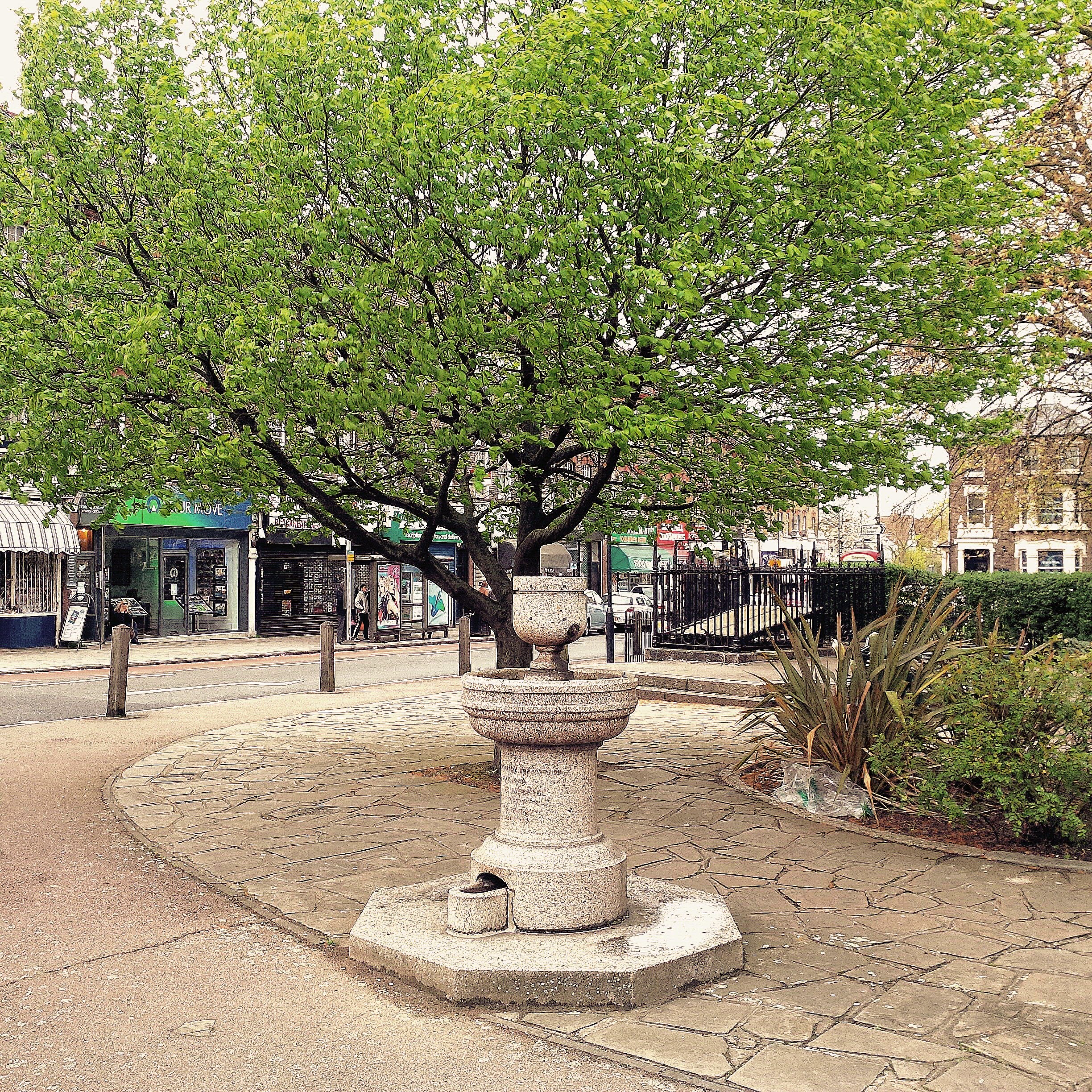

Memorial fountain on south side of Batley Park in the Standard
Two clusters of amenities vie for retail and leisure: the "Village" around Blackheath railway station to the south of the heath and the "Standard" in the north of St Johns/Vanburgh Park i.e. beyond the A2 road, named after the Royal Standard pub[40] (in Greenwich). The north of the green is in the Westcombe Park neighbourhood, which has its own railway station about 400 metres north — part of East Greenwich.[13] The total 0.35-hectare (0.9 acres) green and fountain sub-green was at first one village green, known during the 18th century as Sheepgate Green, beside a crossroads of what was the London-Dover road. Around 1885 local philanthropist William Fox Batley had it refurbished and it became known as Batley Green or Batley Park;[41][42] Batley's contribution is recorded in an inscription on a memorial fountain.
Just south of the railway station is the Blackheath Conservatoire of Music and the Arts. Next door is Blackheath Halls, a concert venue today owned and managed by Trinity Laban Conservatoire of Music and Dance (based in nearby Greenwich).
The heath is host to an annual fireworks display on the Saturday in November closest to Guy Fawkes Night. This was previously organised and financed by the London Boroughs of Greenwich and Lewisham, but Greenwich Council withdrew its share of the funding in 2010.[43]
In September 2014, the inaugural On Blackheath festival was hosted on the heath. The line-up included Massive Attack, Frank Turner, Grace Jones, Aloe Blacc and Imelda May.[44] The festival was also held in 2015 (line-up included Elbow, Madness, Manic Street Preachers, Laura Mvula and Kelis[45]) and 2016 (line-up included Primal Scream, Hot Chip, Belle & Sebastian, James and Squeeze).
Transport


Roundabout on Wat Tyler Road, Blackheath Common
The area is served by Blackheath railway station with services to London Bridge, London Charing Cross, London Victoria, London Cannon Street, Slade Green via Bexleyheath, Dartford via Bexleyheath and via Woolwich Arsenal and to Gravesend via Bexleyheath. The previously direct service to the Medway towns was withdrawn in May 2018.
Blackheath is served by several Transport for London bus services linking the area with Greenwich, Lewisham, Charlton, Woolwich, Catford, Eltham, Sidcup, Bexleyheath, Sydenham, Beckenham, Stratford and Westminster.
See also
- List of people from Greenwich
- List of people from Lewisham
References
- ^ "Lewisham Ward population 2011". Neighbourhood Statistics. Office for National Statistics. http://www.neighbourhood.statistics.gov.uk/dissemination/LeadKeyFigures.do?a=7&b=13688945&c=Blackheath&d=14&e=62&g=6333052&i=1001x1003x1032x1004&o=362&m=0&r=1&s=1476354032570&enc=1. Retrieved 13 October 2016.
- ^ "Blackheath Westcombe Demographics (Greenwich, England)". http://blackheath-westcombe.localstats.co.uk/census-demographics/england/london/greenwich/blackheath-westcombe. Retrieved 13 October 2016.
- ^ "Area guide for Blackheath". Kinleigh Folkard & Hayward. https://www.kfh.co.uk/south-east-london-and-north-kent/blackheath/.
- ^ a b Mills, A.D. (11 March 2010). Dictionary of London Place Names. Oxford. ISBN 978-0199566785.
- ^ http://www.domesdaybook.co.uk/lincolnshire5.html
- ^ a b c d A Topographical Dictionary of England, ed. S. Lewis (London, 1848), pp. 270-275. British History Online http://www.british-history.ac.uk/topographical-dict/england/pp270-275, accessed 11 August 2019.
- ^ se3.org.uk St Michael and All Angels community website
- ^ St John's, Blackheath showing as offshoot E.P. of Greenwich E.P. since 1854 Vision of Britain (website), © 2009-2017, the University of Portsmouth
- ^ All Saints, Blackheath E.P. an offshoot E.P. of Lewisham E.P. since 1859 Vision of Britain (website), © 2009-2017, the University of Portsmouth and others
- ^ The Ascension, Blackheath - an offshoot E.P. of Lewisham E.P. since 1883 Vision of Britain (website), © 2009-2017, the University of Portsmouth and others.
- ^ Blackheath Park (St Michael and All Angels, formerly St Peter's) - an offshoot E.P. of Charlton E.P., Kidbrooke Liberty and Lee E.P. since 1886 Vision of Britain (website), © 2009-2017, the University of Portsmouth and others.
- ^ a b Units covering this area Vision of Britain (website), © 2009-2017, the University of Portsmouth and others
- ^ a b Parish locator and church information by grid reference, A Church Near You, Church of England, retrieved 2019-08-11
- ^ Boundaries of Boundary Map of Kidbrooke Pariochial Liberty/Civil Parish Vision of Britain (website), © 2009-2017, the University of Portsmouth and others.
- ^ Dartford Grammar School. "Roman and Saxon Roads and Transport". dartfordarchive.org.uk. Kent County Council. http://www.dartfordarchive.org.uk/early_history/transport_rs.shtml.
- ^ Patrick Hanks; Flavia Hodges; A. D. Mills; Adrian Room (2002). The Oxford Names Companion. Oxford: the University Press. p. 1003. ISBN 978-0198605614.
- ^ 'Blackheath and Charlton', Old and New London: Volume 6 (1878), pp. 224-236 accessed: 4 November 2009
- ^ By Elizabeth Crawford, ed. The Women's Suffrage Movement: a reference guide, 1866-1928, s.v. "Blackheath"
- ^ "London Gardens Online". London Gardens Online. http://www.londongardensonline.org.uk/gardens-online-record.asp?ID=LEW004. Retrieved 15 June 2013.
- ^ "Vanbrugh Pits on Blackheath". Lewisham.gov.uk. http://www.lewisham.gov.uk/inmyarea/openspaces/parks/blackheath/Pages/Vanbrugh-Pits.aspx. Retrieved 15 June 2013.
- ^ St John's Blackheath: Parish locator and church information by grid reference, A Church Near You, Church of England, retrieved 2019-08-11
- ^ "Mince Pie House, Vanbrugh Fields, Blackheath, c. 1910 | Lewisham Galleries". Ideal Homes. 29 September 2010. http://www.ideal-homes.org.uk/lewisham/assets/galleries/blackheath/mince-pie-house. Retrieved 15 June 2013.
- ^ Homan, Roger (1984). The Victorian Churches of Kent. Chichester: Phillimore & Co. Ltd. pp. 30–31. ISBN 0-85033-466-7.
- ^ In 1669, Sir John Morden, 1st Baronet purchased it for £4,200; the mansion and 283 acres (1.145 km2) were sold in 1783 by Sir Gregory Page-Turner, 3rd Baronet for £22,000 to John Cator.
- ^ Howard Colvin, Biographical Dictionary of British Architects, 1600-1840, 3rd ed. 1995, s.v. "Searles, Michael".
- ^ a b c Details from listed building database (1192114). National Heritage List for England. English Heritage.
- ^ "Our History: Royal Blackheath Golf Club - The Oldest Golf Club in the world". Royalblackheath.com via archive.org. http://www.royalblackheath.com/index.lasso?pg=ec7e88a710c7a8e9&mp=cbc638823c5eb85e. Retrieved 15 July 2011.
- ^ Buckley, p. 4.
- ^ Buckley, p. 52.
- ^ "blackheathcc.com". blackheathcc.com. http://www.blackheathcc.com. Retrieved 15 August 2013.
- ^ "blackheathfencing.org.uk". blackheathfencing.org.uk. http://blackheathfencing.org.uk. Retrieved 15 August 2013.
- ^ "Common Land and the Commons Act 2006". Defra. 13 November 2012. http://www.defra.gov.uk/rural/protected/commons/. Retrieved 3 February 2013.
- ^ "Lewisham Council - Local parks - Blackheath". Lewisham.gov.uk. http://www.lewisham.gov.uk/inmyarea/openspaces/parks/blackheath/Pages/default.aspx. Retrieved 15 June 2013.
- ^ "Blackheath - Greenwich". Royalgreenwich.gov.uk. 30 April 2012. http://www.royalgreenwich.gov.uk/directory_record/3758/blackheath. Retrieved 15 June 2013.
- ^ "Lewisham Council - Local parks - Ponds on Blackheath". Lewisham.gov.uk. http://www.lewisham.gov.uk/inmyarea/openspaces/parks/blackheath/Pages/Ponds.aspx. Retrieved 15 June 2013.
- ^ "Hare and Billet Pond". Nature Conservation Lewisham. 5 October 2012. http://natureconservationlewisham.co.uk/tag/hare-and-billet-pond/. Retrieved 15 June 2013.
- ^ "Lewisham Council - Local Parks - Grasslands on Blackheath". Lewisham.gov.uk. http://www.lewisham.gov.uk/inmyarea/openspaces/parks/blackheath/Pages/Grasslands.aspx. Retrieved 15 June 2013.
- ^ a b c "Lewisham Council - Local parks - Habitat changes and ecological decline of Blackheath". Lewisham.gov.uk. http://www.lewisham.gov.uk/inmyarea/openspaces/parks/blackheath/Pages/Habitat-changes-and-ecological-decline-.aspx. Retrieved 15 June 2013.
- ^ Fries, Theodor Magnus; Jackson, Benjamin Daydon (2011). Linnaeus. Cambridge University Press. p. 158. ISBN 9781108037235.
- ^ TfL http://content.tfl.gov.uk/bus-route-maps/blackheath-royal-stand.pdf
- ^ Westcombe Park Conservation Area: Character Appraisal, March 2010. Accessed: 20 July 2015
- ^ Rimel, Diana (2006), "History of the Standard", Westcombe News Archived 13 March 2011 at the Wayback Machine, February 2006, p.6. Accessed: 20 July 2015.
- ^ "BLACKHEATH: Greenwich Council pulls out of fireworks display". Newsshopper.co.uk. 17 September 2010. http://www.newsshopper.co.uk/news/8399263.BLACKHEATH__Greenwich_Council_pulls_out_of_fireworks_display/. Retrieved 29 August 2011.
- ^ Saturday, 13 September 2014 – Sunday, 14 September 2014, On Blackheath. Retrieved: 24 August 2015.
- ^ 2015 Headliners, On Blackheath. Retrieved: 24 August 2015.
External links
- The Blackheath Society
- Blackheath Village - a local guide of businesses and events in Blackheath, South East London.
 "Blackheath". Encyclopædia Britannica (11th ed.). 1911.
- "Blackheath". Encyclopedia Americana. 1920.
| ||||||||||||||||||||||

| ||||||||||||||||||||

.jpg)
.jpg)
Template:Parks and open spaces in London Template:English cricket venues to 1770
| This page uses content from the English language Wikipedia. The original content was at Blackheath, London. The list of authors can be seen in the page history. As with this Familypedia wiki, the content of Wikipedia is available under the Creative Commons License. |