| Bourgogne-Franche-Comté | |||
|---|---|---|---|
| — Region of France — | |||
|
|||
 |
|||
| Country | France | ||
| Prefecture | Dijon | ||
| Departments | |||
| Government | |||
| • President | Marie-Guite Dufay (Socialist Party) | ||
| Area | |||
| • Total | 47,784 km2 (18,450 sq mi) | ||
| Population (2015) | |||
| • Total | 2,820,940 | ||
| • Density | 59/km2 (150/sq mi) | ||
| Time zone | CET (UTC+1) | ||
| • Summer (DST) | CEST (UTC+2) | ||
| NUTS Region | |||
Bourgogne-Franche-Comté (French pronunciation: [buʁɡɔɲ fʁɑ̃ʃ kɔ̃te], sometimes abbreviated BFC; meaning Burgundy–Free County) is a region of France created by the territorial reform of French Regions in 2014, from a merger of Burgundy and Franche-Comté. The new region came into existence on 1 January 2016, after the regional elections of December 2015, electing 100 members to the regional council of Bourgogne-Franche-Comté.[1]
The region covers an area of 47,784 km2 (18,450 sq mi), and has a population of 2,816,814.[2]
Toponymy[]
The text of the territorial reform law gives interim names for most of the merged regions, combining the names of their constituent regions separated by hyphens. Permanent names would be proposed by the new regional councils and confirmed by the Conseil d'État by 1 October 2016.[3] Hence the interim name of the new administrative region is composed of the names of former administrative regions of Burgundy (Bourgogne) and Franche-Comté. The region chose to retain its interim name as its permanent name, a decision made official by the Conseil d'État on 28 September 2016.[4]
The merger represents a historic reunification of the Duchy of Burgundy (Duché de Bourgogne) and the Free County of Burgundy (Franche Comté de Bourgogne), for the first time since they were divided in 1477.
History[]
Middle Ages[]
The territory that is now Burgundy and Franche-Comté was already united under the Kingdom of Burgundy (from the 5th to the 8th century). It was divided into two parts: the Duchy of Burgundy (now Burgundy) of France, and the County of Burgundy (now Franche-Comté) of the Holy Roman Empire. The County was reintegrated as a free province within the Kingdom of France in the 17th century, separately from the Duchy which remained a vassal province of the Kingdom of France. These two former provinces were abolished during the French Revolution.
")
")
Modern times[]

Map of the new region with its eight départements, colored according to the historical provinces as they existed until 1790.
Most of the area making up the region of Bourgogne-Franche-Comté used to belong to the former provinces of Burgundy and Franche-Comté, but it also includes a significant part of the former provinces of Nivernais (now Nièvre), Champagne (now the northern part of Yonne), Orléanais (now the southwestern part of Yonne), the Territoire de Belfort (the region of Alsace that remained French territory after 1871), and a small portion of Île-de-France (now the northwestern part of Yonne).
From 1941 to 1944, the regional prefecture of Vichy reunited Burgundy and Franche-Comté, as well as the igamie of Dijon from 1948 to 1964. During the creation of the regions of France, Burgundy and Franche-Comté once again became two separate regions, first as public establishments in 1972, then as territorial collectivities in 1982.
On 14 April 2014, François Patriat and Marie-Guite Dufay (the presidents of Burgundy and Franche-Comté, respectively) announced in a press conference the desire for the reunification of the two regions, further to the declarations of Prime Minister Manuel Valls, who proposed a simplification of the administrative divisions of France.
On 2 June 2014, the two regions were shown as one on the map presented by President François Hollande. These two regions are the only ones to have voluntarily discussed a merger, and their alliance was the only one not needing revision by the National Assembly or the Senate.
Under the Acte III de la décentralisation, the merger of the two regions was officially adopted on 17 December 2014. It became effective on 1 January 2016.
Geography[]
The region borders Grand Est to the north, Île-de-France to the northwest, Centre-Val de Loire to the west, Auvergne-Rhône-Alpes to the south and Switzerland (the cantons of Vaud, Neuchâtel and Jura) to the east.
The distances from Besançon, the capital of the region, to other cities are:
- Paris, the national capital, 410 km (255 mi);
- Bordeaux, 729 km (453 mi);
- Toulouse, 762 km (473 mi);
- Marseille, 538 km (334 mi);
- Lyon, 227 km (141 mi);
- Montpellier, 523 km (325 mi);
- Nice, 694 km (431 mi).
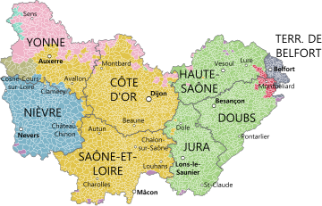
Departments[]
Bourgogne-Franche-Comté comprises eight departments: Côte-d'Or, Doubs, Jura, Nièvre, Haute-Saône, Saône-et-Loire, Yonne, Territoire de Belfort.
Major communities[]
- Dijon (151,212; headquarters regional prefecture)
- Besançon (116,914; headquarters regional council)
- Belfort (50,078)
- Chalon-sur-Saône (44,985)
- Nevers (36,762)
- Auxerre (34,869)
- Mâcon (33,865)
")
")
")
")
.JPG "Port (1).JPG (617 KB)")
See also[]
References[]
- ^ "La carte à 13 régions définitivement adoptée" (in French). Le Monde. Agence France-Presse. 17 December 2014. http://www.lemonde.fr/politique/article/2014/12/17/la-carte-a-13-regions-definitivement-adoptee_4542278_823448.html. Retrieved 13 January 2015.
- ^ "Populations légales 2012 - Populations légales des régions". Insee. http://www.insee.fr/fr/ppp/bases-de-donnees/recensement/populations-legales/france-regions.asp?annee=2012. Retrieved 16 January 2015.
- ^ Loi n° 2015-29 du 16 janvier 2015 relative à la délimitation des régions, aux élections régionales et départementales et modifiant le calendrier électoral (in French)
- ^ Décret n° 2016-1268 du 28 septembre 2016 portant fixation du nom et du chef-lieu de la région Bourgogne-Franche-Comté (in French)
External links[]
| Wikivoyage has a travel guide for Bourgogne-Franche-Comté. |
| ||||||||||||||||||||||||