| Innisfail | |
 The township of Innisfail, as seen from Coquette Point | |

Innisfail | |
| Population: | 8,262 (2006)[1] |
| Established: | 1879 [2] |
| Postcode: | 4860 |
| Coordinates: | Coordinates: |
| Elevation: | 10 m (33 ft) [3] |
| Location: |
|
| LGA: | Cassowary Coast Region |
| State District: | Mulgrave |
| Federal Division: | Kennedy |
Innisfail is a town located in the far north of the state of Queensland, Australia. It is the major township of the Cassowary Coast and is well renowned for its sugar and banana industries, as well as for being one of Australia's wettest towns. In March 2006 Innisfail gained worldwide attention when severe tropical cyclone Larry passed over causing extensive widespread damage.[4][5]
History[]
Prior to European settlement the Innisfail area was occupied by five separate societies of the Mamu people. These Aboriginal people followed migratory lifestyles in the rainforest and transverse rivers in string-bark canoes.
The first incursion by European people came in 1872 when survivors of the shipwreck "Maria" arrived on the coastal areas surrounding what is now the Johnstone River. Sub-Inspector Robert Johnstone's search party came with the intention of rescuing remaining survivors and to punish the Aboriginal people who had abused them. The crew would later venture up river between what is today Flying Fish and Coquette Points. Johnstone wrote very highly of the area, stating:
A most glorious view appeared - a noble reach of fresh water, studded with blacks with their canoes and catamarans, others on the sandy beaches; deep blue fresh water expanding to an imposing breadth.—Robert Johnstone (1872), [2]
Johnstone named the area after himself and upon his recommendation the explorer George Darlymple arrived in the area in September 1873 to chart the area further.
Later in 1879, Irishman Thomas Henry FitzGerald arrived in the area to help establish the sugar industry. He was accompanied by large numbers of Kanaka South Sea Islanders workers with smaller numbers of Irish labourers. The house built FitzGerald and consequently first establishment in the area was called Innisfallen; the romantic name for Ireland, and after the largest island in the Lakes of Killarney, Ireland.
From 1879, settlement was named Geraldton after FitzGerald, but in 1912 was renamed 'Innisfail' to avoid confusion with the town of the same name in Western Australia.
The 1920s and 1930s saw the beginning of a major period settlement by Italian immigrants and noteworthy populations from Greece and Malta. Later in this period populations from Yugoslavia, India, Pakistan and the Philippines would also settle in the area.[2][6]
Culture[]
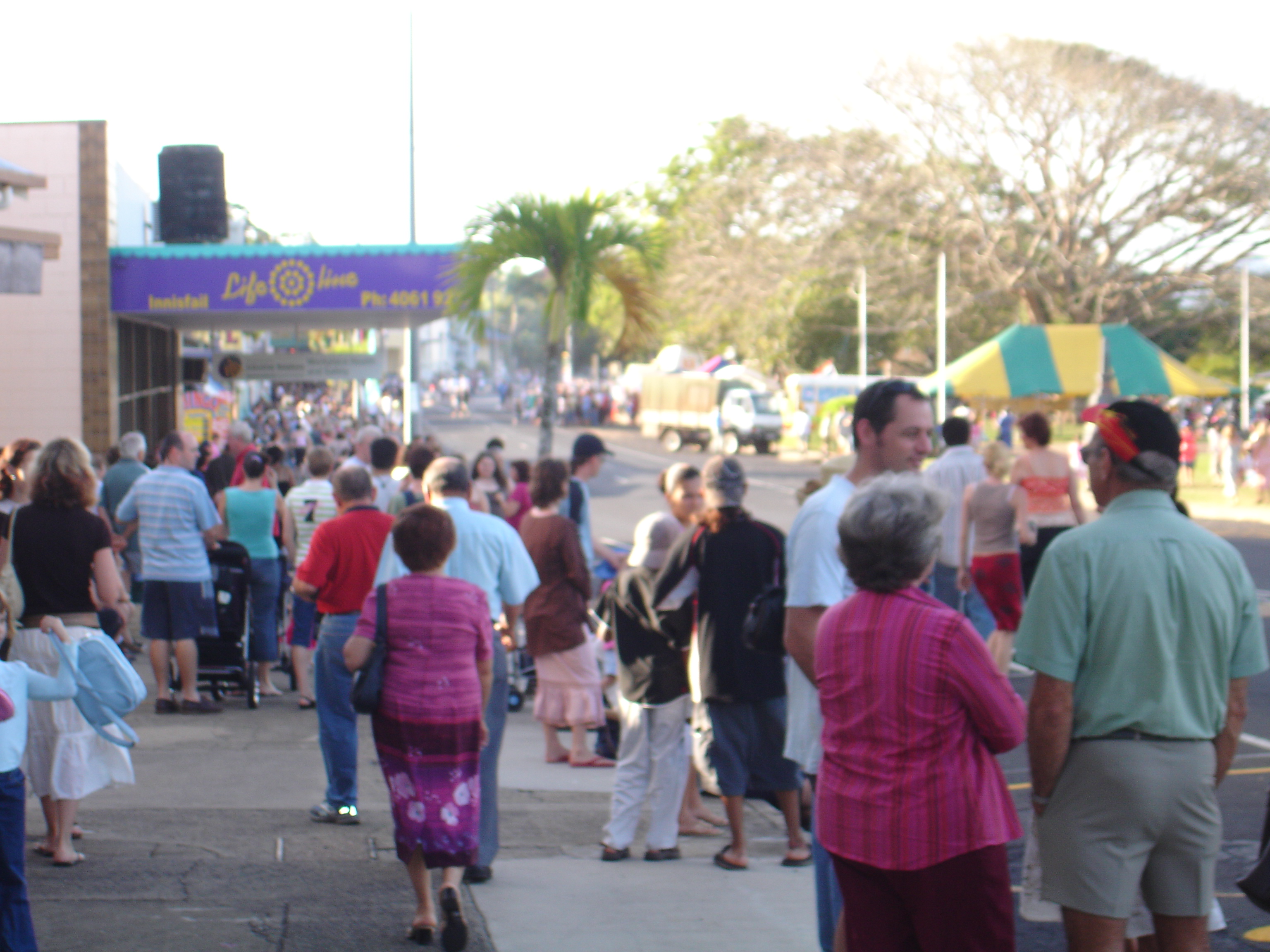

A large turnout of the Annual Harvest Festival Parade in 2005
Culture[]
Today Innisfail remains incredibly multicultural, with prominent populations of indigenous Australians, Europeans (in particular Italians), Indians and East Asians (in particular Hmongs).[7][8][9]
There are a number of events that take place annually to celebrate the cultural diversity within the Innisfail community:
- Kulture Karnival
- Festival Innisfail
- Feast of the Senses
- Feast of the Three Saints
Such events are extremely popular amongst residents and attract good turnouts.[10]
In 2001 Los Angeles band Sugar Ray filmed part of their music DVD "Music In High Places" at the Johnstone Crocodile Farm in Innisfail.
Community[]
Being a small community, and one that was recently subjected to a severe natural disaster Innisfail harbours a definite sense of community. The township has only 2 secondary schools: Good Counsel College and Innisfail State High School and a single business district.
There are many events that act predominantly as community events, the main ones include:
- The Innisfail Rodeo
- Harvest Festival
- Annual Show
Whilst Innisfail was always reputed to have a positive sense of community spirit, the aftermath of Tropical Cyclone Larry and the unified cleanup effort acted to promote this spirit through shared suffering.[11]
Geography[]
Innisfail's town centre is situated at the junction of the North and South Johnstone Rivers, approximately 5 km (3 mi) from the coast.[12] It is located near large tracts of old-growth tropical rainforest surrounded by vast areas of extensive farmlands. Queensland's highest mountain, Mount Bartle Frere; part of Australia's Great Dividing Range, is 15 kilometres (9 mi) to the north.[13]
Climate[]
Innisfail experiences a tropical rainforest climate (Köppen climate classification Af) as it lies between the tropic of Capricorn and the equator causing an exclusively tropical climate.[14] Consistently, humid, warm weather is common in Innisfail. In particular Innisfail is reputed as being amongst the wettest towns in Australia.[15] Tully, 52 kilometres (32 mi) south of Innisfail is generally considered to be the wettest. Unlike most of tropical Australia[16], the dry season is not completely dry as easterly winds bring frequent showers[17]; rainfall is, however, still far lower than during the southern summer. Monthly totals of over 1,000 mm (39 in) are a routine occurrence in the region between January and April[18].
| Climate data for Innisfail | |||||||||||||
|---|---|---|---|---|---|---|---|---|---|---|---|---|---|
| Month | Jan | Feb | Mar | Apr | May | Jun | Jul | Aug | Sep | Oct | Nov | Dec | Year |
| Average high °C (°F) | 30.8 (87.4) |
30.6 (87.1) |
29.8 (85.6) |
28.3 (82.9) |
26.4 (79.5) |
24.5 (76.1) |
24.1 (75.4) |
25.1 (77.2) |
26.7 (80.1) |
28.4 (83.1) |
29.7 (85.5) |
30.8 (87.4) |
27.9 (82.2) |
| Average low °C (°F) | 22.8 (73.0) |
22.8 (73.0) |
22.1 (71.8) |
20.4 (68.7) |
18.3 (64.9) |
16.1 (61.0) |
15.1 (59.2) |
15.4 (59.7) |
16.9 (62.4) |
18.9 (66.0) |
20.8 (69.4) |
22.0 (71.6) |
19.3 (66.7) |
| Precipitation mm (inches) | 509.2 (20.047) |
599.8 (23.614) |
660.7 (26.012) |
459.3 (18.083) |
301.1 (11.854) |
189.3 (7.453) |
135.3 (5.327) |
118.2 (4.654) |
85.4 (3.362) |
83.1 (3.272) |
154.9 (6.098) |
264.9 (10.429) |
3,567.0 (140.433) |
| Source: Australian Bureau of Meteorology[19] | |||||||||||||
Cyclones[]


Howe St. in East Innisfail is commonly affected by even minor flooding
Innisfail is consistently under threat from tropical cyclones developing in the Coral Sea in and around summer months.[20] Furthermore, high rainfall associated with aforementioned cyclones and monsoons, combined with Innisfail settlement on adjoining rivers causes flooding to be commonplace, occurring to varied degrees of severity annually.[21] Innisfail suffered extensive damage in 2006 due to Cyclone Larry as the site of landfall and received over 100mm of rain in the span of three hours.
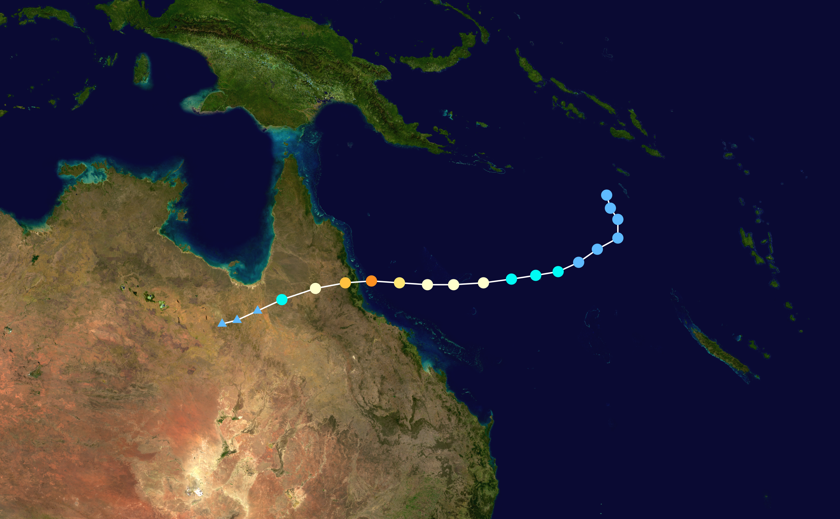

Cyclone Larry storm path, the storm eye passed directly over Innisfail
Tropical Cyclone Larry, an Australian Category 4 cyclone (initially thought to be Category 5), struck the locality at 7am on 20 March 2006, with the eye of the storm passing over the town.
Severe structural damage occurred over the entirety of the township, the main damage being a portion of houses losing roofs and windows and the cyclone rendered even more homes structurally unsound. Power was effectively eliminated from the town and generators became a luxury in many homes. Clean drinking water was also compromised in many homes leading to health fears. The swift response of the Australian Defence Force was praised by many and the clean up campaign they orchestrated allowed for total utilities restoration within 3 weeks. Severe damage was done to crops and plantations (mainly bananas) which had a serious economic impact on the region. Only 1 indirect death was record as a result of the cyclone.
Cyclone Larry was a direct and primary cause of the widely reported and dramatic surge in banana prices in Australia. Inflated cost remained until farmers were able to meet demand again in early 2007.[22][23][24]
Council Controversy[]


The Innisfail Central Business District as it is today
On 8 February 2007 the Johnstone Shire Council was sacked by the Queensland State Government by Queensland's Local Government Minister, Andrew Fraser because of internal conflict, inappropriate behaviour and financial problems, despite an issued show cause presented on 2 August 2006.[25][26]
Amongst the perceived gross misconduct were the following incidences:
- The purchase of a $250 000 Steinway Model D Piano with insurance money from Cyclone Larry.[27]
- Former Deputy Mayor George Pervan was quoted on commercial radio during an interview during the aftermath of Cyclone Larry requesting Southern Queenslanders to:
"Send up a truckload of piss so we can all get fucking drunk" - George Pervan - 2006 [28]
Whilst 2 councillors had attempted to get the Queensland Government to revoke the decision Andrew Fraser has stated that whilst the action is regrettable it was indeed the correct decision.[29]
Innisfail today[]
At present Innisfail has largely recovered from the devastation of Cyclone Larry. After the cyclone the township underwent something of an economic boom that stemmed from an influx of tradespeople and business eager to capitalize upon relatively significant insurance payouts. According to reports local trade had increased some 30 - 40% opposed to expected increases of 10%.[30] [31]
The main industries remain predominately banana and sugar cane and have since recovered from the natural disaster. Outlying areas of Innisfail have also resumed manufacture of tea, pawpaws and other exotic fruits.[32]
Innisfail remains a popular destination for backpackers seeking employment in the fruit picking industry. Tourism is of importance to the township and the town consistently seeks to attract visitors passing through on the Bruce Highway.[33]
| Long Distance services | ||||
|---|---|---|---|---|
| Inbound | Service | Outbound | ||
| Tully | The Sunlander | Babinda | ||
| Tully | Diesel Tilt Train | Babinda | ||
Notable Residents[]
- Steve Corica:Retired Footballer who was capped numerous times for Australia and played in England, notably for Wolverhampton Wanderers, was also capped over 100 times for Marconi Stallions in the ex-NSL and Sydney FC in the A-League.
Gallery[]
")
")
")
")
See also[]
- Banana
- Cyclone Larry
- Devil's Pool
- Far North Queensland
- Paw Paw
- Sugar Cane
References[]
- ^ Australian Bureau of Statistics (25 October 2007). "Innisfail (Urban Centre/Locality)". 2006 Census QuickStats. http://www.censusdata.abs.gov.au/ABSNavigation/prenav/LocationSearch?collection=Census&period=2006&areacode=UCL329200&producttype=QuickStats&breadcrumb=PL&action=401. Retrieved {{{accessdate}}}.
- ^ a b c "Walkabout - Innisfail". http://walkabout.com.au/locations/QLDInnisfail.shtml. Retrieved 2006-06-02.
- ^ "Innisfail - Australian Bureau of Meteorology statistics". http://www.bom.gov.au/climate/averages/tables/cw_032025.shtml. Retrieved 2006-06-02.
- ^ "Tourism and Regional Information". http://www.innisfail.oz-e.com.au/facts.html. Retrieved 2006-06-02.
- ^ "Australian Bureau of Meteorology Severe Tropical Cyclone Larry Report". http://www.bom.gov.au/weather/qld/cyclone/tc_larry/. Retrieved 2006-06-02.
- ^ "History of the Innisfail Region". http://www.innisfail.oz-e.com.au/hist.html. Retrieved 2006-06-02.
- ^ "SRA Fact Sheet Innisfail - Australian Government". http://www.indigenous.gov.au/sra/qld/fact_sheets/qld04.html. Retrieved 2006-06-02.
- ^ "Innisfail Pioneers - Italian History" (PDF). http://www.multiculturalaustralia.edu.au/doc/innisfail_pioneers.pdf. Retrieved 2006-06-02.
- ^ "Cultural Diversity in the Johnstone Shire Council". http://www.lgaq.asn.au/lgaq/general/community/CulturalDiversity/Johnstone_Shire_Council_of_Month.html. Retrieved 2006-06-02.
- ^ "About Johnstone Shire Council". http://www.jsc.qld.gov.au/business/index.shtml. Retrieved 2006-06-02.
- ^ "Community Spirit - Winter 2007". http://www.communities.qld.gov.au/department/publications/communityspirit/2007/edition9/life-after-larry.html. Retrieved 2006-06-02.
- ^ "Innisfail - Google Maps". http://maps.google.com/maps?f=q&hl=en&geocode=&q=innisfail+qld&ie=UTF8&z=13&om=1. Retrieved 2006-06-02.
- ^ "Mt. Bartle Frere Trail". http://www.townsvillenet.com.au/mountains/bartlefrere.htm. Retrieved 2006-06-02.
- ^ Linacre, Edward; Geerts, Bart (1997). Climates and Weather Explained. London: Routledge. p. 379. ISBN 0-415-12519-7. http://books.google.com.au/books?id=mkZa1KLHCAQC&lpg=PA379&pg=PA379#v=onepage&q=&f=false.
- ^ "Tully - Cairns Connect". http://www.cairnsconnect.com/region/tully.asp. Retrieved 2006-06-02.
- ^ Median Rainfall for July
- ^ See Mean rainfall May to September for an explanation
- ^ Innisfail monthly rainfalls
- ^ "Climate statistics for Innisfail AWS". Australian Bureau of Meteorology. http://www.bom.gov.au/climate/averages/tables/cw_032025.shtml. Retrieved 10 May 2009.
- ^ "List of Queensland Cyclones - Windworker Roof Renovations". http://www.windworker.com.au/qldcyclones.htm. Retrieved 2006-06-02.
- ^ "Flood Warning system for the Johnstone River". http://www.bom.gov.au/hydro/flood/qld/brochures/johnstone/johnstone.shtml. Retrieved 2006-06-02.
- ^ "ABC news - Innisfail Devastated". http://www.abc.net.au/news/newsitems/200603/s1595732.htm. Retrieved 2006-06-02.
- ^ "Australian Banana Growers Council - Cyclone Larry Report". http://www.abgc.org.au/pages/media/cyclonelarry.asp. Retrieved 2006-06-02.
- ^ "Sydney Morning Herald - Disaster drives big price surge". The Sydney Morning Herald. 2006-03-21. http://www.smh.com.au/news/national/disaster-drives-big-price-surge/2006/03/20/1142703287961.html. Retrieved 2006-06-02.
- ^ "ABC - Sacking of JSC". http://www.abc.net.au/news/stories/2007/02/08/1843394.htm. Retrieved 2006-06-02.
- ^ "Queensland Government - Show Cause Issued". http://statements.cabinet.qld.gov.au/MMS/StatementDisplaySingle.aspx?id=47579. Retrieved 2006-06-02.
- ^ "Innisfail splashes out on $250k piano with insurance money - The Courier Mail". http://www.news.com.au/couriermail/story/0,23739,21909730-421,00.html. Retrieved 2006-06-02.
- ^ "News.com.au - Sacked Council gone bananas". http://www.news.com.au/story/0,23599,21200048-421,00.html. Retrieved 2006-06-02.
- ^ "ABC news story - 'Ineffective Council Sacked'". http://www.abc.net.au/news/stories/2007/02/08/1843394.htm. Retrieved 2006-06-02.
- ^ "Innisfail Business booming after cyclone - ABC report". http://www.abc.net.au/news/stories/2006/05/19/1642580.htm. Retrieved 2006-06-02.
- ^ "APIA set up in Innisfail". http://www.apia.com.au/news-article-010506-cyclone-larry.asp. Retrieved 2006-06-02.
- ^ "Australian Tropical Fruits". Archived from the original on May 4, 2006. http://web.archive.org/web/20060504005539/http://www.australiantropicalfoods.com/gourmetinfo.html. Retrieved 2006-06-02.
- ^ "Innisfail tourism". http://www.innisfailtourism.com.au/content/view/18/50/. Retrieved 2006-06-02.
External links[]
- University of Queensland: Queensland Places: Innisfail
- Innisfail Homepage
- Detailed History of Innisfail
- Cassowary Connect Local Events Website for Innisfail
| This page uses content from the English language Wikipedia. The original content was at Innisfail, Queensland. The list of authors can be seen in the page history. As with this Familypedia wiki, the content of Wikipedia is available under the Creative Commons License. |