| Main | Births etc |
|---|
| Kensington Sydney, | |||||||||||||
 University of NSW | |||||||||||||
| Population: | 10,849 (2006 Census) | ||||||||||||
| Postcode: | 2033 | ||||||||||||
| Location: | 4 km (2 mi) south-east of Sydney CBD | ||||||||||||
| LGA: | City of Randwick | ||||||||||||
| State District: | Heffron, Coogee | ||||||||||||
| Federal Division: | Kingsford Smith | ||||||||||||
| |||||||||||||
Kensington is a suburb in south-eastern Sydney, in the state of New South Wales, Australia. It is located 6 kilometres south-east of the Sydney central business district, in the local government area (LGA) of the City of Randwick, in the Eastern Suburbs region. Colloquially, Kensington is referred to as "Kenso".
Kensington lies to the immediate south of Moore Park and west of Randwick Racecourse. The principal landmarks of the suburb are the main campus of the University of New South Wales, National Institute of Dramatic Art (NIDA), and the exclusive Australian Golf Club. Kensington is also a residential suburb close to the Sydney CBD. There is a mixture of high- and medium-density housing, and free-standing homes for its 11,000 residents.
History[]
Aborigines[]
The original inhabitants of the area were tribes of Aboriginal. The Cadigal people were part of the salt-water clans, in the Darug language group and their land. The Cadigal people were known for their fishing skills and often travelled in canoes. The 1828 census showed some 50-60 clans of Cadigal people living by the Lachlan swamps of Kensington and surrounding areas. Swamps provided fruit, nectar, roots and tubers. Very few Aboriginals live in Kensington today.[1]
European settlement[]
The suburb now known as Kensington was once called the "Lachlan Mills Estate", "Stannumville" and then "Epsom". It became Kensington in the late 1880s, starting life as an industrial suburb. Samuel Terry, the convict who became Australia’s first millionaire, received a land grant in 1819. Daniel Cooper (1785–1853), also an ex-convict acquired land here in 1825 with his partner Solomon Levey, whom he later bought out. Cooper's nephew Daniel (1821–1902) planned to subdivide but in 1865 all developments was forbidden. Residential land was issued in the late 1880s and Kensington was to be the equivalent of London’s distinguished suburb, Kensington.
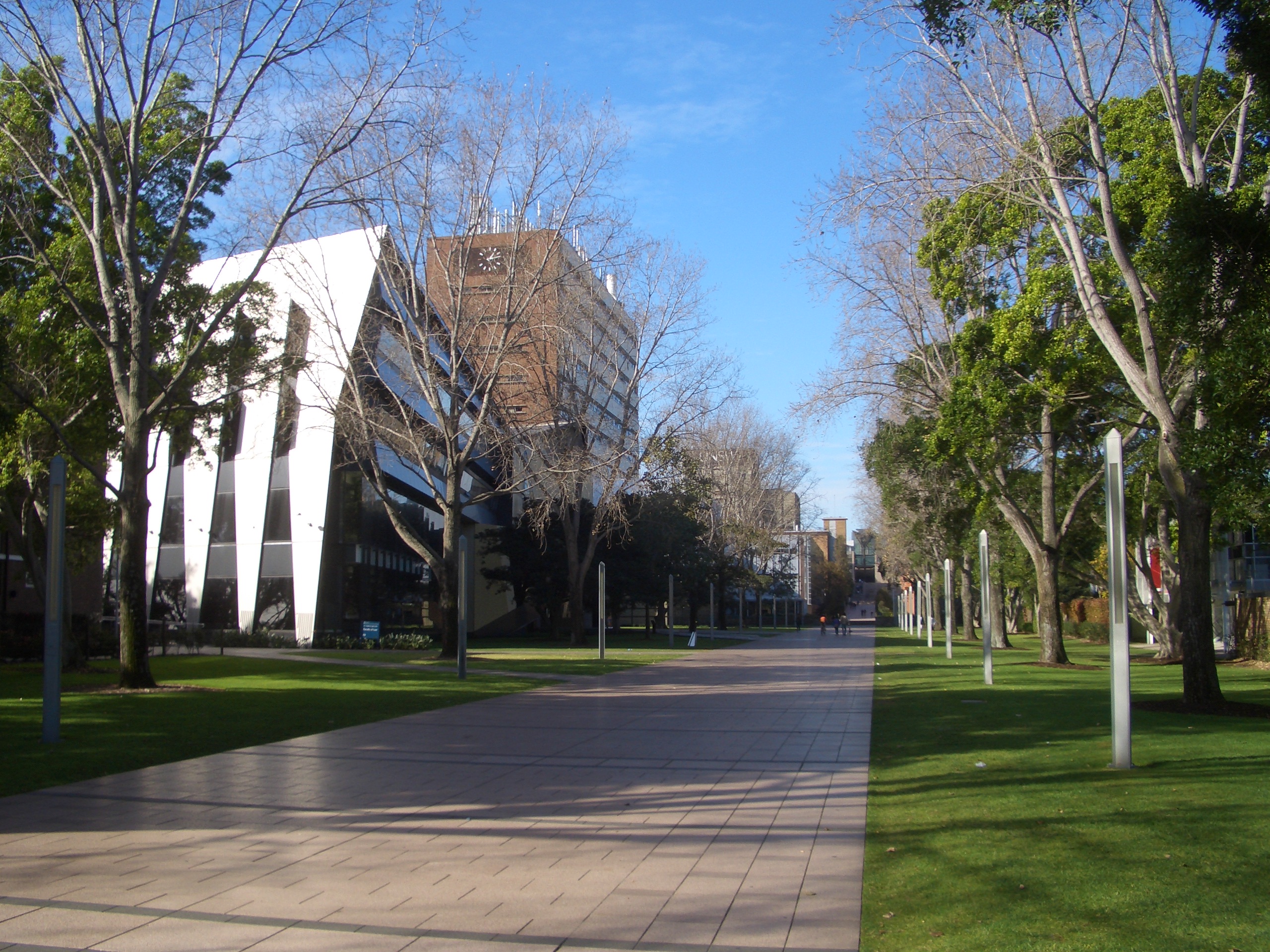
Kensington Racecourse opened in 1893 on the site of the current University of New South Wales. It did not compete with nearby Randwick Racecourse because it held midweek meetings, pony racing and related sports like polo. The course was also used to house troops and horses during the Boer War and World War I. The land was resumed in 1950 to construct Sydney's second university.[2]
Sacred Heart Monastery

Our Lady of the Sacred Heart Convent


NIDA, Anzac Parade
The W.D. & H.O. Wills tobacco factory opened in the northern part of the suburb in 1902.[3] The factory site also featured the Raleigh Park Social Club, an extensive sporting complex named after Sir Walter Raleigh who first introduced tobacco from North America to Europe. The factory closed in 1989 and was slowly converted into a high density residential neighbourhood.[4]
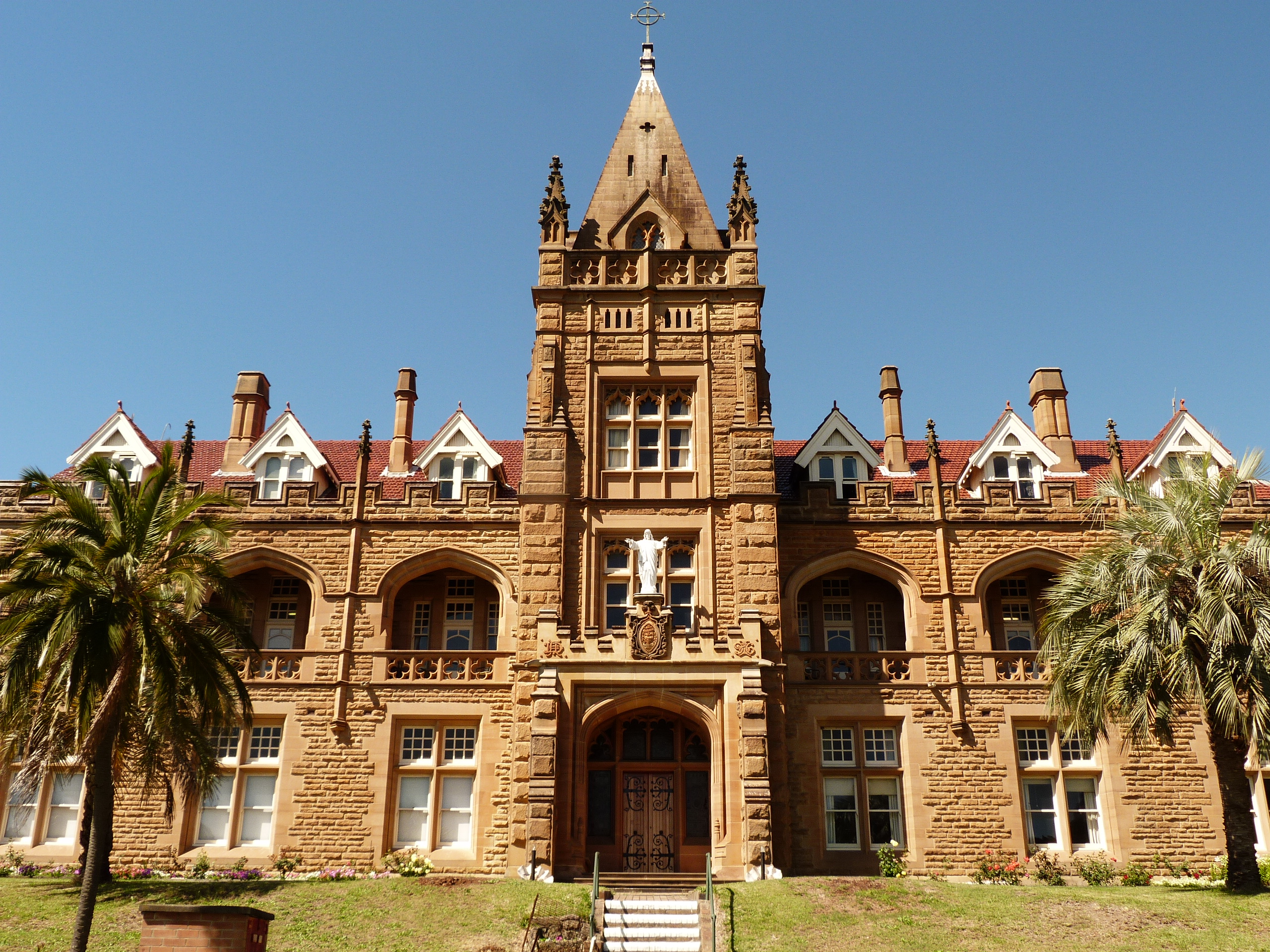
The hill that dominates West Kensington is occupied by the Sacred Heart Monastery, the Australian headquarters of the Catholic Missionaries of the Sacred Heart.[5] The monastery was designed by Hennessy and Sheerin and built in 1895. It is a large stone building in the Gothic style and features an attic storey and a prominent central tower. It also includes a brick chapel in a Romanesque-Byzantine style which was designed by Mullane and built in 1939, and which is joined to the monastery by a matching brick cloister. The monastery is a prominent landmark which can be seen from various parts of Kensington and is now listed on the Register of the National Estate.[6]
Adjacent to the monastery is the Our Lady of the Sacred Heart Convent, a brick building in Federation Free Gothic style, which was built in 1897. It was the original site for primary and secondary colleges that were established soon after the construction of the convent, but these soon outgrew the premises. It is now the base for OLSH Provincial House and St Joseph's Aged Care Facility, while Our Lady of the Sacred Heart College is situated next door. Across the road is Our Lady of the Rosary Church (built 1906), Jubilee Hall and the Our Lady of the Rosary Primary School, which complete a large religious complex. The convent and church are heritage-listed.[7]
In the mid-twentieth century, the monastery was the home of the anti-Communist organiser Dr P.J. ('Paddy') Ryan and the popular Catholic controversialist Dr Leslie Rumble.
Kensington’s streets are named after local people, places in London and local flora. Some examples are:
- Balfour Lane – Arthur James Balfour, the first earl of Balfour, a British statesman and Prime Minister (1902–1905)
- Doncaster Avenue – Named after the racecourse in England
- Boronia Street – A flowering shrub grown extensively in the area.[8]
Tram history[]
The line from Surry Hills to West Kensington commenced as a steam powered system in 1881. At this point the line travelled along Crown Street as far as Cleveland Street. The line was then extended to Phillip Street in 1909, Todman Avenue in 1912, and then to its final terminus down Todman Avenue, West Kensington in 1937.
The line commencing from the city branched off from the tramlines in Oxford Street and ran down Crown Street to Cleveland Street in Surry Hills, then south along Baptist Street to Phillip Street, where it swung left into Crescent Street before running south along Dowling Street, tuning left into Todman Avenue where it terminated.[9] Services operated full-time from Circular Quay, and to Railway in peak hours. The line down Crown Street closed in 1957, the remainder stayed open until 1961 [10] to allow access to Dowling St Depot, (the current site of the Supa Centa Moore Park - Shopping Centre).[11]
As well as servicing West Kensington, tram services also operated on Anzac Parade, servicing the Maroubra and La Perouse line.[12][13] Recent plans to extend the current light rail network from Central Station to La Perouse via Anzac Parade have been put on hold.[12][14]
Tay Park (bounded by Tay Street, Anzac Parade and Alison Road) is the site of the old Toll Bar where local maintenance revenue was collected from 1854 to 1894. The toll was 1 shilling for a four-wheeled wagon drawn by 2 horses.[15]
Sydney Buses routes 301, 302 and 303 generally follow the route down Crown and Baptist Streets as far as Phillip Street.
Commercial area[]
Kensington is heavily influenced by the University of New South Wales and the Racing Industry. It has a handful of cafes, restaurants and shops. Kensington has a shopping strip that extends most of the length of Anzac Parade and further south into Kingsford. 'Peters of Kensington' is a well known retail store on Anzac Parade. Kensington is next to Randwick Racecourse and Centennial Park.
Transport[]
Anzac Parade is the main road through Kensington. Numerous buses frequently service Kensington, linking it with the city and surrounding suburbs. There are no trains or light rail service, since the 1976 review of the Eastern Suburbs Railway abandoned the planned extensions to Kensington.
On 13 December 2012, the NSW Government announced a commitment to build a $1.6 billion light rail from Circular Quay down George Street to Central Station, then across to Moore Park and down Anzac Parade. South of Moore Park the line will spit into two branches - one of which will continue down Anzac Parade to the nine ways at Kensington.[16] A bus/tram interchange will be established in Kensington and many of the bus routes that currently traverse Anzac Parade to access the city would be replaced by feeder routes connecting to the light rail.[17]
Geography[]
Topography[]
Kensington is located in the geographic zone known as the Botany Lowlands. The sands beneath Kensington act as a large water reservoir. Originally, Kensington was quite rugged, consisting of hills, deep gullies and 768 acres (3.1 km²) of swamps, crossed by the Lachlan Stream. Evidence of the swamps can be seen in the south-west corner of the Royal Randwick Racecourse and the ponds of Centennial Park. After long periods of heavy rain some parts of Kensington are prone to flooding. Today Kensington has been levelled with hills cut down and voids filled with the excess soil from the hills.
Flora and fauna[]
In the 3 square kilometres that cover Kensington, there are 5 parks, which account for almost 1/4 of the total area. Banksias, Bottlebrushes, Waratah, Wattles and Eucalypts are some of the 400 odd native plants found in Kensington. Randwick City Council has recorded approximately 250 species of indigenous native vertebrates. 206 species of native birds have been found since 1788.
Water supply[]
Water for Kensington is piped from Warragamba Dam. Kensington does however have two natural water sources; the Lachlan Stream and an underground reservoir.[18] Due to water restrictions and council initiatives, more and more residence are using bore water on their gardens. Others still are installing tanks and using 'grey' water.
Demographics[]
Kensington has a wide range of ethnic backgrounds. Only 56.4% of residents were born in Australia. The most common countries of origin for the remaining residents include the UK, Indonesia, New Zealand, and China. Aboriginal and Torres Strait Islanders are in the minority, with only 39 in the suburb.
As in any multicultural society, a variety of religions are represented. There are Anglican, Roman Catholic, and Greek Orthodox churches in the area and other religions practised include Buddhism, Hinduism, Judaism and the Muslim faith.
Politics[]
In local government, Kensington is in the West Ward of Randwick City Council. It is in the electorates of Coogee and Heffron for the State parliament; and the Kingsford-Smith electorate represented by Peter Garrett (Labor) for the Federal parliament (as of February 2013).
Schools and churches[]


Our_Lady_of_the_Rosary_Church_Kensington.jpg)
Our Lady of the Rosary Church

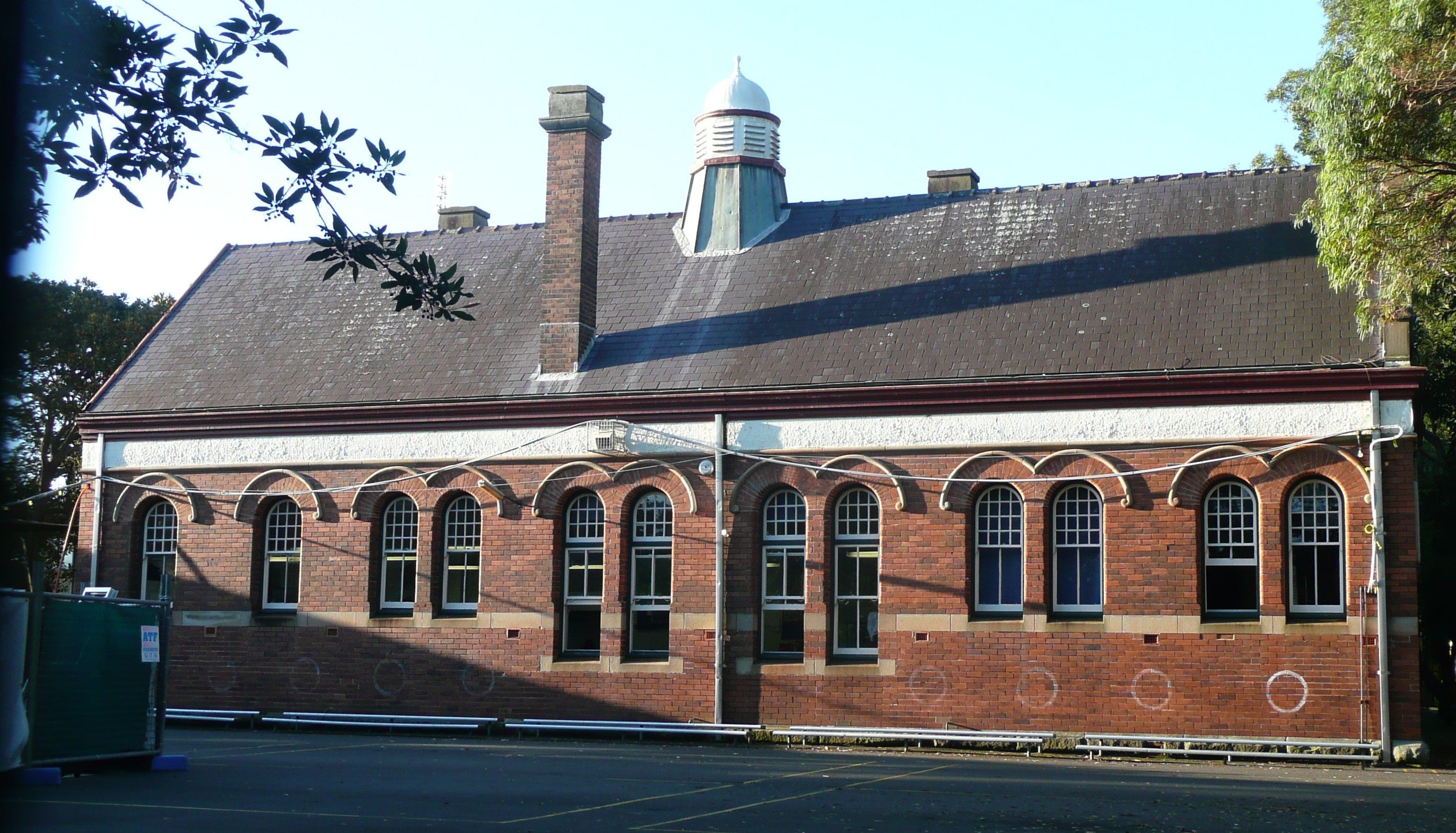
Kensington Public School, Doncaster Avenue
- Kensington Public School
- Our Lady of the Rosary Primary School
- Our Lady of the Sacred Heart College (High School).[19]
- University of New South Wales
- The National Institute of Dramatic Art, located opposite to University of New South Wales on Anzac Parade.
- St Martins Anglican Church
- Our Lady of the Rosary Catholic Church
- St George Coptic Orthodox Church
- FOCUS Indonesia Church (Gereja Focus Indonesia), UNSW Kensington Campus [20]
References[]
- ^ Turbet. P. (2001). The Aboriginies of the Sydney District before 1788. Roseville, N.S.W: Kangaroo Press.
- ^ Waugh, J. W. (1997). Kensington Racecourse – 1890 - 1942. Randwick, N.S.W: Randwick and District Historical Society Inc.
- ^ Randwick City Council. Industry & Innovation in Randwick. Accessed 5 February 2008.
- ^ Lang, J. Urban Design: A Typology of Procedures and Products.Accessed 5 february 2008.
- ^ Caruana, A. (2000). Monastery on the Hill – A History of the Sacred Heart Monastery – Kensington 1897-1997. Kensington, N.S.W: Nelen Yubu Missiological unit.
- ^ The Heritage of Australia, Macmillan Company, 1981, p.2/58 ISBN 0-333-33750-6
- ^ State Heritage Register
- ^ "Origins of Street and Place names in Randwick". Anonymous.
- ^ Gregory's Street directory, circa 1945, map 11, ref K6
- ^ http://www.dictionaryofsydney.org/video/19048 Last tram on Anzac Parade 1961 (video)
- ^ Gregory's Street directory, circa 1945, map 11, ref J/3
- ^ a b "Bring back trams: mayor makes a pitch for Anzac Parade". Sydney Morning Herald. 22-09-2009.
- ^ http://www.tundria.com/trams/AUS/Sydney-1958.shtml
- ^ http://www.ecotransit.org.au/ets/files/ble_update_oct2002.pdf
- ^ Keenan, D. (1982). The South-Eastern lines of the Sydney tramway system. Sans Souci, N.S.W: Transit Press.
- ^ "Sydney's Light Rail Future". Transport for New South Wales. 13 December 2012. pp. 15, 24. http://haveyoursay.nsw.gov.au/document/show/601. Retrieved 14 December 2012.
- ^ "Sydney's Light Rail Future". Transport for New South Wales. 13 December 2012. pp. 13, 16, 17. http://haveyoursay.nsw.gov.au/document/show/601. Retrieved 14 December 2012.
- ^ Waugh, J. W. (1997). Kensington – Land use, Development, Ownership and Control on the Lachlan Stream 1810-1890. Randwick, N.S.W: Randwick and District Historical Society Inc.
- ^ OLSH Welcome
- ^ Indonesian Focus Church
- Destitute Children’s Asylum Cemetery. South Eastern Sydney Health Service, 1996, p. 2.
- Fitzgibbon, W. (2003, June, 3). Doncaster Plaza Development Approved. Southern Courier, p. 6.
- Lawrence, J. (2001). Pictorial History, Randwick. Alexandria, N.S.W: Kingsclear Books.
- McMahon, J. F. (1986). Kensington – A Model Suburb. Randwick, N.S.W: Randwick and District Historical Society.
- Quick, D. (1985). Randwick- A social History. Kensington, N.S.W: New South Wales University Press.
- Randwick Historical Society (personal communication, March 12, 2005).
- Randwick Historical Society. (1986). A Randwick Ramble Part 2 – Randwick and Kensington. Randwick, N.S.W: Randwick Historical Society.
 Media related to Kensington, New South Wales at Wikimedia Commons
External links[]
| ||||||||
| This page uses content from the English language Wikipedia. The original content was at Kensington, New South Wales. The list of authors can be seen in the page history. As with this Familypedia wiki, the content of Wikipedia is available under the Creative Commons License. |