| Province of Teramo | |||
|---|---|---|---|
| — Province — | |||
 |
|||
|
|||
 |
|||
| Country | |||
| Region | Abruzzo | ||
| Capital(s) | Teramo | ||
| Comuni | 47 | ||
| Government | |||
| • President | Renzo Di Sabatino | ||
| Area | |||
| • Total | 1,948 km2 (752 sq mi) | ||
| Population (28 February 2011) | |||
| • Total | 312,311 | ||
| • Density | 160/km2 (420/sq mi) | ||
| Time zone | CET (UTC+1) | ||
| • Summer (DST) | CEST (UTC+2) | ||
| Postal code | 64100 | ||
| Telephone prefix | 0861 | ||
| Vehicle registration | TE | ||
| ISTAT | 067 | ||

The Province of Teramo is located in the Abruzzo region of Italy. Its capital is the city of Teramo. The province has an area of 1,948 square kilometres (752 sq mi), a population of 313,029 (2012), and is subdivided into 47 comunes (Italian: comuni), see Comunes of the Province of Teramo. The Province of Teramo shares its northern border with the Province of Ascoli Piceno in the Marche Region, southern and southwestern borders with the Province of L'Aquila in the Abruzzo Region, and a western border with the Province of Rieti in the Region of Lazio. To the south is the Abruzzo Province of Pescara and to the east is the Adriatic Sea.
Geography[]
The landscape of the Province of Teramo is dominated almost entirely on the east by a large body of water with the beaches of the Adriatic sea and by the Apennine Mountains which his highest peak of Gran Sasso d'Italia westside. The province is indeed divided latitudinally by the characteristic hills and valleys rich in vineyards and olive groves that begin in the Apennines and run almost to the coast. Colline Teramane (Teramo Hills) has become a trademark and are one of the most significant areas where extra virgin olive oil and Abruzzo wines are produced.[1] Unique of the province of Teramo is the short distance between the beaches of the Adriatic sea and the 3,000-metre (9,800 ft) snowcapped Gran Sasso peaks. They can be reached within an hour from one point to the other.
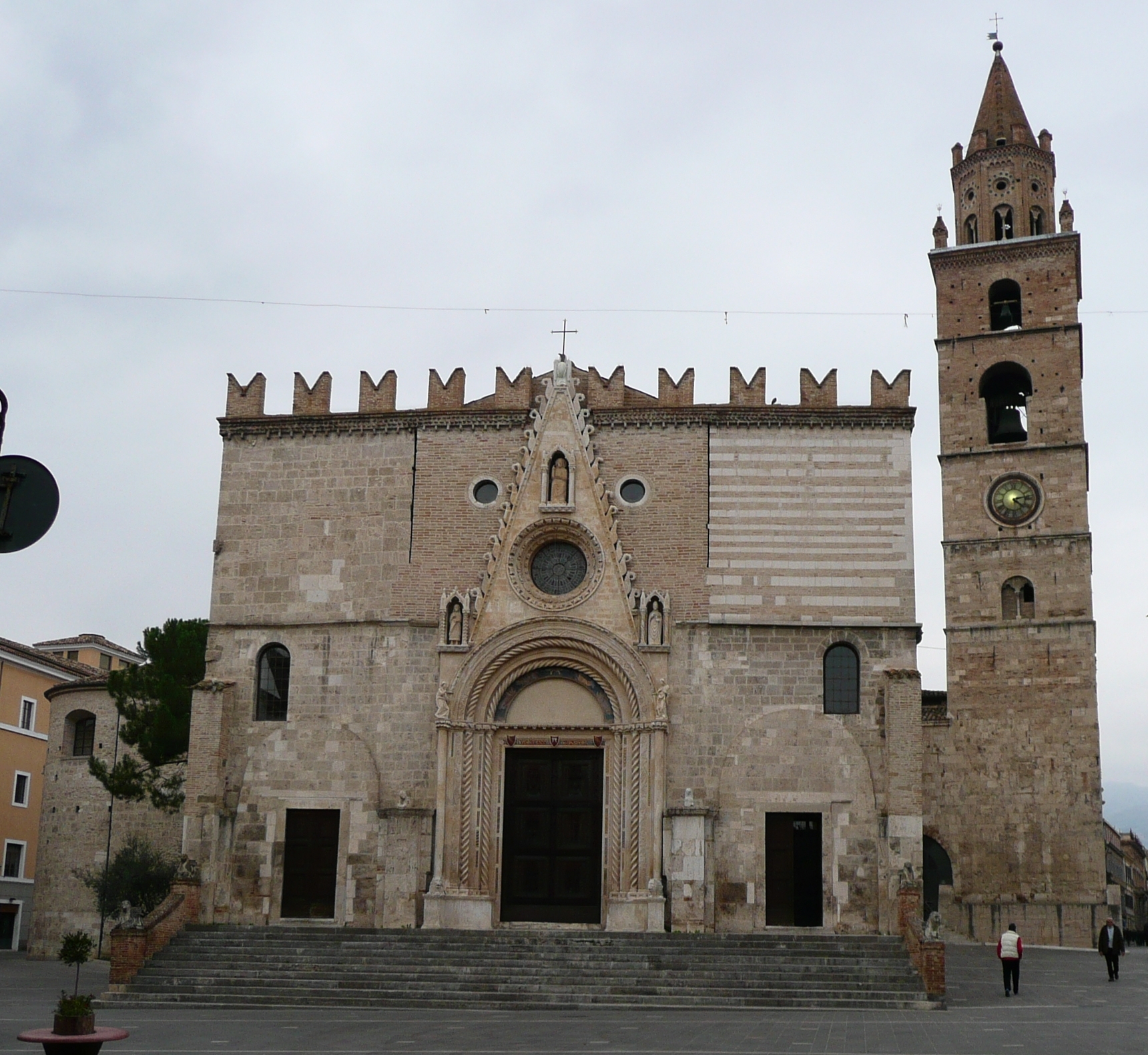

Teramo Cathedral
The peaks of the Gran Sasso rise to the west of the Province of Teramo while those of the Monti della Laga dominate its northern border. These two ridges are among the most distinctive and the most relevant of the entire Apennine Mountain range. The majestic Gran Sasso rises at its peak, the Corno Grande, to an elevation of 2,912 metres (9,554 ft) and is characterized by steep, and in places virtually inaccessible, gorges with nature reserves and protected living species. A good part of Gran Sasso and Monti della Laga National Park is nestled in the province. Calderone, the southernmost glacier in Continental European, is found nearby. In contrast to the rugged and isolated Gran Sasso area, the Monti della Laga are characterised by thick forests, shallow gorges, rolling slopes and valleys, and several spectacular waterfalls.
In addition to the provincial capital, the most populous and important commercial centers include Roseto degli Abruzzi and Giulianova with populations of 24,000 and 22,000 inhabitants respectively. On the eastern portion of the province are the so-called "seven sister" beaches directly adjacent to the Adriatic Sea. These resorts are noted for one the highest blue flag beaches density, very fine white sand and their mild and wholesome Mediterranean climates which support a rich flora of palm, pine and oleander trees. Much of the province is hilly and very few large flat plains are to be found. Running from the west to the east are a number of valley streams and rivers which eventually empty into the Adriatic Sea. The province of Teramo can easily be reached by car or bus from Rome via the A24 highway and it is also connected to the A14 highway.
Culture[]
The Province of Teramo holds a great many art treasures including several very early Christian-era temples. Dotted among the countryside are hilltop towns which once served as watchpoints and guardians of the deep and rocky valleys below. Connecting these treasures are important roads and trails that cut from the east to the west. Many of these follow shepherding routes that once dominated the area. Two important towns in the Province of Teramo are Civitella del Tronto and Atri. The first stood as the northernmost protective point of the Bourbon Empire. It was the last fortress to fall into the hands of the conquering French forces of Savoy. Still today, this fortress and the thriving town at its base testify to the power that the Kingdom of the Two Sicilies once possessed. In Atri there is a Roman Catholic cathedral and an imposing theatre. The town's heritage comes from the importance of the once powerful Counts of Acquaviva who laid claim to this region. The provincial capital of Teramo hosts a large cathedral and has for centuries served all of Abruzzo as a main administrative and economic center.
On 15 September 2005 the President of Italy, Carlo Azeglio Ciampi, went to Teramo to make a special presentation in honour of the resistance movement that arose in this town against the Nazi forces during the Second World War. A special note was made of the young Italian partisans who gathered in the village of Bosco Martese. There they risked deportation, severe reprisals, and other barbarous acts. Several of them, most famously Mario Capuani, gave their lives during these struggles.[2]
Tourism[]
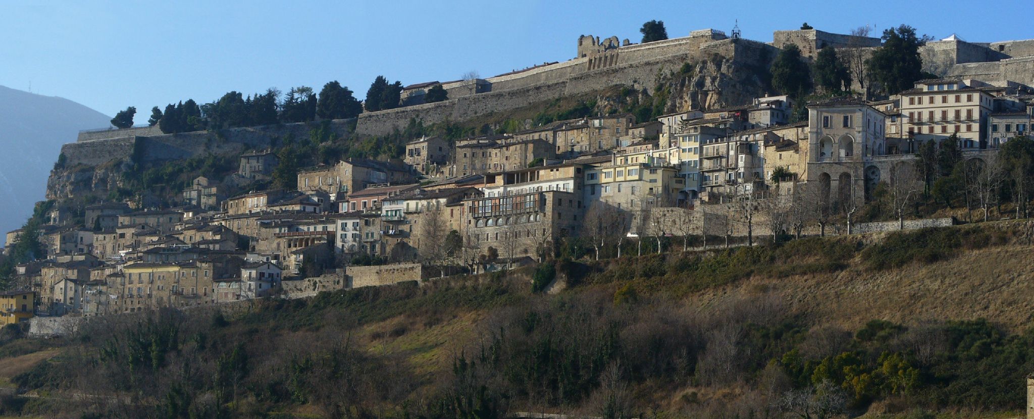

The town and fortress of Civitella del Tronto.
Man tourist attractions include:
- Atri, including an erosion phenomenon called "Bolge" and see the treasures of the Count of Aquaviva.
- Campli - a characteristic village once possession of the Farnese Family. Its St Paul Church holds a Scala Sancta.
- Castelli is a village 25 miles away (40 km) from Teramo. It is known for its maiolicas. In the past local artisans produced ceramics for most of the royal houses of Europe.
- Civitella del Tronto - Bourbon fortress which is the most visited monument of the Abruzzo region, surrounding village e and gole del Salinello.[3] The place holds a significative importance in the history of Italy unification.
- Colline Teramane (Teramo hills) are a very distinctive and significant area where extra virgin olive oil and Abruzzo wines are produced.[4]
- Montagne Gemelle (Twin Mountains) of the Gran Sasso and Monti della Laga National Park are two suggestive mountains standing alongside. They are often taken as one of the symbols of the province of Teramo.
- Montorio al Vomano - historical medieval town and its cathedral.
- Teramo - cathedral and museums.
- Gran Sasso and Monti della Laga National Park.
- The Shrine of Gabriel of Our Lady of Sorrows with average of 2 million visitors per year is one of the 15 most visited sanctuaries in the world.[5]
From north to south, the province of Teramo boasts several blue flag beaches on the Adriatric Seacoast, called the seven sisters, are the following:
- Martinsicuro
- Alba Adriatica
- Tortoreto
- Giulianova
- Roseto degli Abruzzi
- Pineto
- Silvi Marina
Transportation[]
Major highways[]
The Province of Teramo can be reached from the north and the south by the main highway, the A14, that runs along the Adriatic Coast. It can be reached from the west by the A24 coming from Rome via L'Aquila.
Railroad lines[]
The central railroad station of the province is located in Giulianova. From here is it possible to follow the coastline to the north and south or to travel in a westerly direction towards the provincial capital.
Seaports[]
The port of Giulianova is the maritime terminal of the Province of Teramo.
Administration[]
Since 2009, the president of the province has been Valter Catarra of the centre-right political party.
Major comuni[]
The main comuni and towns by population as of 2005 are:
Teramo (52,794), Roseto degli Abruzzi (23,669), Giulianova (21,875), Silvi Marina (15,247), Martinsicuro (15,047), Pineto (13,763), Atri (11,269), Alba Adriatica (11,219), Sant'Egidio alla Vibrata (9,177), Mosciano Sant'Angelo (8,559), Tortoreto (8,536), Montorio al Vomano (8,072), Campli (7,598), Bellante (7,208).
Gallery[]
")
")
")
")
")
-Italy.jpg "Castelli(TE)-Italy.jpg (760 KB)")
")
")
")
")
")
")
")
")
")
")
References[]
- ^ http://www.hotelposeidontortoreto.com/en/abruzzi-wine-and-food_31.html
- ^ http://resistenzateramana.blogspot.it/2005/09/il-presidente-della-repubblica-ciampi.html
- ^ http://www.corriere.it/cultura/speciali/2010/visioni-d-italia/notizie/3civitella-del-tronto-Serenissimi-e-borbonici-insieme-per-disfare-l-Italia_b3bc7456-550c-11df-a414-00144f02aabe.shtml
- ^ http://www.hotelposeidontortoreto.com/en/abruzzi-wine-and-food_31.html
- ^ http://turismo.provincia.teramo.it/art-and-culture/churches/shrine-of-saint-gabriele-dell92addolorata-96-isola-del-gran-sasso/?set_language=en
External links[]
- Province of Teramo Homepage (in Italian)
- Abruzzo 2000 - Province of Teramo Information
- Gran Sasso National Park
| ||||||||||||||||||||

Template:Province of Teramo
|
| This page uses content from the English language Wikipedia. The original content was at Province of Teramo. The list of authors can be seen in the page history. As with this Familypedia wiki, the content of Wikipedia is available under the Creative Commons License. |