| ||||||||||||||
| Tirunelveli district திருநெல்வேலி மாவட்டம் |
|
|---|---|
| — District — | |
| Nickname(s): Nellai | |
 |
|
| Coordinates: Coordinates: | |
| Country | |
| State | Tamil Nadu |
| District | Tirunelveli |
| Metro | |
| District formed on | September 01, 1790 |
| Headquarters | Tirunelveli |
| Talukas | Tirunelveli, Palayamkottai, Sankarankovil, Ambasamudram, Nanguneri, kadayanallur Radhapuram, Tenkasi, Shenkottai, Alangulam, Veerakeralampudur, Sivagiri |
| Government | |
| • Collector & District Magistrate | Dr. R. Selvaraj, IAS |
| Area | |
| • Total | 6,823 km2 (2,634 sq mi) |
| Population (2011)[1] | |
| • Total | 3,072,880 |
| • Density | 410.5/km2 (1,063/sq mi) |
| Languages | |
| • Official | Tamil |
| Time zone | IST (UTC+5:30) |
| PIN | 627001 |
| Telephone code | 0462 |
| ISO 3166 code | [[ISO 3166-2:IN|]] |
| Vehicle registration | TN-72/76 |
| Coastline | 35 kilometres (22 mi) |
| Largest city | Tirunelveli |
| Sex ratio | M-49%/F-51% ♂/♀ |
| Literacy | 68.44%% |
| Legislature type | elected |
| Legislature Strength | 11 |
| IUCN category | |
| Precipitation | 814.8 millimetres (32.08 in) |
| Avg. summer temperature | 37 °C (99 °F) |
| Avg. winter temperature | 22 °C (72 °F) |
| Website | nellai.tn.nic.in |
Tirunelveli District is a district of Tamil Nadu state in southern India. The city of Tirunelveli is the district headquarters. A unique feature of this district is that it encompasses all five geographical traditions of Tamil Literature; kurinji (mountains), mullai (forest), marudham (paddy fields), neithal (coastal) and palai (desert). Tirunelveli District was formed on September 1, 1790[2][3] by the East India Company (on behalf of the British government), and comprised the present Tirunelveli and Thoothukudi districts and parts of Virudhunagar and Ramanathapuram districts. It is the second-largest district (as of October 2008), after Villupuram district.
History[]
Tirunelveli District was called as Thenpandiyanadu under the Pandyas rule.
This Area was under Cholas. They named Tirunelveli Mudikonda Cholamandalam under their rule.
Then this area was ruled by Madurai Nayaks. During their period Tirunelveli was called as Tirunelveli Seemai.
Under the British East India Company rule, it was Tinnevelly district. That comprised present Tirunelveli and Thoothukudi districts and parts of Virudhunagar and Ramanathapuram districts.
In 1910 Ramanathapuram District was formed by clubbing portions from Madurai and Tirunelveli district, which comprised portions of Today's Virudhunagar District.
After the Independence of India, Tirunelveli district was bifurcated on 20th October 1986 to Nellai-Kattabomman (Today's Tirunelveli) district and Chidambaranar (Today's Tuticorin) district. Subsequently, per the decision of the Government of Tamil Nadu to call all the districts by the name of the headquarter town, the name was changed from Tirunelveli-Kattabomman district to Tirunelveli district.[4]

Nellaippar Temple
Geography and climate[]


The Agasthiyamalai hills cut off Tirunelveli from the southwest monsoon, creating a rainshadow region
The district is located in the southern part of Tamil Nadu. It is surrounded by Virudhunagar District in the north, the Western Ghats in the west, Kanyakumari District in the south and Thoothukudi District in the east. The district covers an area of 6,823 km2. It lies between 8°05’ and 9°30’ north latitude and 77°05’ and 78°25’ east longitude. The district has diverse geographical and physical features. It has mountains (a stretch of the Western Ghats and lowland plains. It has a perennial river (the Tamirabarani) and small seasonal rivers. The district has many scenic waterfalls. Its physical features include sandy soil and fertile alluvium, a variety of flora, fauna and protected wildlife. The district also has inland and mountainous forests.
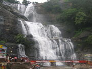
Tirunelveli has rainfall in all seasons (953.1 mm in 2005-2006). The district benefits from both the northeast and southwest monsoons. Most precipitation came from the northeast monsoon (548.7 mm) followed by the southwest monsoon (147.8 mm) and summer rains (184.2 mm). The district is irrigated by several rivers originating in the Western Ghats such as the Pachaiyar River, which flows into the Tambaraparani River. The Tambaraparani and Manimuthar Rivers have many dams, with reservoirs providing water for irrigation and power generation. The Tamiraparani River provides consistent irrigation to a large agricultural area.[5] The Chittar River also originates in this district. The Courtallam and Manimuthar waterfalls are the two major falls in the district.
Demographics[]
According to the 2011 census Tirunelveli district has a population of 3,072,880,[6] roughly equal to the nation of Oman[7] or the US state of Iowa.[8] This gives it a ranking of 116th in India (out of a total of 640).[6] The district has a population density of 458 inhabitants per square kilometre (1,190 /sq mi) .[6] Its population growth rate over the decade 2001-2011 was 13.66%.[6] Tirunelveli has a sex ratio of 1024 females for every 1000 males,[6] and a literacy rate of 82.92%.[6]
The population at the 2001 census was 2,723,988. Of that population, 48.03% was urban with a population density of 410.5 people per square kilometer.[9] Tamil was the main language spoken followed by Malayalam. Hindus formed the majority religious group of the population (79.76%), followed by Christians (10.89%), Muslims (9.26%) and other religions (0.09%).[10]
Infrastructure[]
The district is well-connected by a network of roads and railways. Tirunelveli city serves as the main junction. It has no airports; the nearest airports are at Tuticorin (40 km away), Madurai (150 km) and Thiruvananthapuram. The district has a total of 27 Railway stations. Given below are tables listing the length of roads and railways in the district.[11]
| Roads | National highways | State highways | Corporation and Municipalities Roads | Panchayat Union and Panchayat Road | Town Panchayat and Townships Road | Others (forest roads) |
|---|---|---|---|---|---|---|
| Length (km.) | 174.824 | 442.839 | 1,001.54 | 1,254.10 and 1,658.35 | 840.399 | 114.450 |
| Railways | Route length (km) | Track length (km) |
|---|---|---|
| Broad gauge | 257.000 | 495.448 |
| Meter gauge | 0.000 | 0.000 |
Canals, wells, tanks and reservoirs are the sources of irrigation in the district. As of 2005–2006, the district had a total of 151 canals with a length of 499 km, 85,701 irrigation wells, 640 tube wells, 8 reservoirs and 2,212 tanks. The district also has 21,776 wells used for domestic purposes. Electricity is provided by the Tamil Nadu Electricity Board (TNEB).[11] The district has hydroelectric power plants and windmills, with an installed capacity of 1,089.675 MW; it is one of the major producers of wind energy in the state. The Koodankulam Nuclear Power Plant project is being undertaken (with Russian aid) at the village of Koodankulam. Koodankulam is a place in the Tirunelveli district in Tamil Nadu, India. It is situated 24 km north-east of Kanyakumari, 36 km from Nagercoil and about 106 km from Thiruvananthapuram.
The place is notable as the construction site of the Kudankulam Nuclear Power Plant. It is also the location of hundreds of windmills used for power generation, eight of which are located inside the grounds of the nuclear plant. These wind turbines have currently a total capacity of 2000 MW and represent one of the largest wind farms in India.[1]
Since the beginning of 2011, this place has been embroiled in a nuclear plant controversy over fears of the plant safety.
Education and social development[]
Tirunelveli is known for its educational institutions, many of which are located at Palayamkottai (east of Tirunelveli). For this reason, Palayamkottai is known as the "Oxford of South India". The district has a literacy rate of 76.97%, which is above the state average. As of 2005–2006, the district had a total of 2,494 schools. It has one university (the Manonmaniam Sundaranar University). There are also four government colleges, eleven government-sponsored colleges and seven private colleges.[11]
Tirunelveli has the following educational institutions:
- Universities: 1[12]
- Arts and science colleges: 25
- Medical College: 1
- Siddha medical college: 1
- Veterinary College and Research institute
- Engineering colleges: 20
- Law school: 1
- Pre-kindergartens: 241
- Primary schools: 1,501
- Middle schools: 431
- High schools: 114
- Higher secondary schools: 185
- Teacher-training institutes: 28
Manonmaniam Sundaranar University[]
Manonmaniam Sundaranar University (MSU) was established in 1990. Named after poet Sundaram Pillai, the university has a network of 102 affiliated colleges. Many of these colleges have contributed to higher education for decades; five colleges are more than 100 years old. The University campus is located at Abishekapatti, nine km from Tirunelveli town. Advanced studies are offered in a number of departments, and postgraduate programmes in Tamil, Management studies, Chemistry, Communications, Computer science, English, Environmental studies, History, Mathematics, Physics, Sociology, Criminology studies, Psychology and Statistics are offered.
The university has introduced compulsory core courses in Indian studies. The curriculum includes "History of Freedom Movement in India", "Gandhian Thought", "Ecology, Environment and Pollution Studies", "Status of Women in India", "History of Science", "Indian Economy Since Independence", "Rural India", "Consumer Protection and Social Responsibility in Business" and "Secularism". It has set up a centre for environmental studies at Alwarkurichi in collaboration with a corporation, Amalgamations. Eco-friendly ventures in aquaculture and fishing are encouraged. The centre has developed an organic manure, "Mano compost".
Collegiate education[]
In 1878, there were two colleges in the district: the Madurai Diraviam Thayumanavar Hindu College and St. John’s College. The first college for women (and third college of the district), Sarah Tucker College, began in 1895. The fourth and fifth colleges (St. Xavier’s and St. Ignatius Colleges of Education) were established in 1923 and 1957, respectively. In 1963-64 two more colleges, the Paramakalyani and Parasakthi Colleges, were added. The Ambai Arts and Thiruvalluvar Colleges (1969), Muthuramalinga Thevar College and Government Arts College for Women (1970), and the Sadaktathullah Appa and T.D.M.N.S. Colleges (1971) were established in the district. Except for Government Arts College for Women, all the other schools are private colleges run by educational trusts. There are three self-financing colleges: Saratha College for Women (1986), Sattanathakarayalar College (1994–95) and Jayaraj Annabakkiam College (1997–98).
Of the 17 arts colleges in the district eight are coeducational institutions, five are for girls and four for boys. The colleges in Tirunelveli district were originally affiliated with the University of Madras. Upon the creation of Madurai Kamaraj University in 1966, they were affiliated with MKU from 1966 to 1990. In 1990, their affiliation transferred to Manonmaniam Sundaranar University. The university has granted autonomous status to St. Xavier’s College in Palayamkotti and Sri Parasakthi College for Women in Courtallam. The Regional Directorate of the Collegiate Education in the district was formed on 10 September 1979 to regulate colleges in Tirunelveli, Thoothukudi and Kanyakumari districts.
School districts[]
In 1986, the Revenue District of Tirunelveli was divided into Tirunelveli and Thoothukkudi districts. A new post, District Educational Officer at Tenkasi, was created. The names of posts of District Educational Officer, Tirunelveli Central was changed to District Education Officer, Tirunelveli; the District Educational Officer, Tirunelveli South was redesignated District Educational Officer, Cheranmahadevi. The three District Education Officers serve under the Chief Education Officer.
| Education officials | Jurisdiction |
|---|---|
| District Educational Officer, Tirunelveli | Taluks of Tirunelveli, Palayamkottai and Sankarankoil |
| District Educational Officer, Cheranmahdevi | Taluks of Ambasamudram, Nanguneri and Radhapuram |
| District Educational Officer, Tenkasi | Taluks of Tenkasi, Shencottai, Alangulam, VK Pudur and Sivagiri |
| District Adult Education Officer | Entire district |
| District Elementary Educational Officer | Entire Tirunelveli district (primary and upper-primary schools) |
| Assistant Elementary Educational Officers (21) | One for each of the 19 panchayat unions and two for urban areas |
| Additional Assistant Elementary Educational Officers (21) | One for each of the 19 panchayat unions and two for urban areas |
Legal education[]
In Tirunelveli district, a [(GOVERNMENT LAW COLLEGE)] was established to meet the requirements of the people of the southernmost part of Tamil Nadu in the year 1996 and was opened on 14 October 1996 with 80 students for the three-year law course affiliated to Manonmaniam Sundaranar University as the Fifth Government Law College in the State . A five-year B.L course is also offered from the Academic Year 2000-01.From the Academis Year 1997-98 the college is affiliated to the Tamil Nadu Dr. Ambedkar Law University, Chennai. At first, classes were held at the Ponnusamy Pillai Bungalow on Tiruchendur Road in Palayamcottai before its new building was constructed. The College has started functioning from October 2000 in its own new building in an area of 15 acres adjacent to District Court Buildings on the Tiruchendur High Road.
As directed by the Bar Council of India Semester System has been introduced for both (3 yrs and 5 yrs) Law Courses from the Academic Year 2002-03.The year 2007 set another milestone in the history of this college when M.L Degree in Constitutional Law and Human Rights was started.
Medical education[]
The Tirunelveli Medical College and its teaching hospital are located on about 280acres of land at High Grounds, Palayamcottai. It was established in 1965 and affiliated with the University of Madras, with 75 students for the academic year 1965-66. These students took their first-year courses at local arts and science colleges. In July 1966, the first group of second-year MBBS students attended the classes in the newly constructed Anatomy Block. Other departments (such as pharmacology, pathology, microbiology and social and preventive medicine) began in subsequent years and the district-headquarters hospital was converted to Tirunelveli Medical College Hospital. The college was affiliated with Madurai Kamaraj University after its inception in 1967. Since 1988, upon the formation of The TN Dr MGR Medical University, Chennai it has been affiliated with that university. The college was recognised by the Medical Council of India, New Delhi in 1978. The number of seats for the MBBS course was increased from 75 to 100 in 1980, and that year the state government also authorised postgraduate courses. The college celebrated its Silver Jubilee in 1990. The Number of MBBS Seats offered was increased to 150 seats in 2003 and was recognized in 2008 (on par with the like of Madras Medical College, Govt Stanley Medical College & Madurai Medical College)
The Government Siddha Medical College was establisheded at Palayamkottai on 30 November 1964. This was an affiliated College of the University of Madras until March 1966; from then until 1988 it was an affiliate of Madurai Kamaraj University, and since March 1989 of Dr. MGR Medical University.
Technical education[]
Technical education in the district dates to 1844, when Mrs. Caldwell (wife of Bishop Robert Caldwell) began a school to teach girls lace-making at Idyangudi. The government of Tamil Nadu set up a State Board of Technical Education and Training and a separate Directorate of Technical Education, effective 1 October 1957. Since then, the Directorate of Technical Education has assumed the administration of both engineering colleges and polytechnics since then.
The Government College of Engineering was established in October 1981 to fulfill the needs of people in the southern region. At first the college met in a bungalow near Tirunelveli Medical College, since new buildings were under construction. In 1984, the college moved into new buildings on its 25-hectare (62 acres) campus. It is currently located about 8 km from Tirunelveli Junction on the Tirunelveli-Trivandrum Highway. From its inception, the College admitted students in three undergraduate departments: civil, electronics and communication and mechanical engineering; electrical and electronics engineering was introduced during 1986-87, and computer science and engineering was added in 1989-90. A postgraduate course in computer science and engineering was introduced in 1994-95.
Economic profile[]
Tirunelveli has been an agricultural area throughout its history. The district is a major producer of rice, coconuts, bananas, spices and forest-based products. The district's livestock and poultry populations are as follows:[11]
| Cattle | Buffalo | Sheep | Goats | Pigs | Horses and Ponies | Donkeys | Rabbits | Total livestock | Total poultry |
|---|---|---|---|---|---|---|---|---|---|
| 418,694 | 78,777 | 487,273 | 390,570 | 12,752 | 245 | 961 | 2401 | 67,877 | 1,218,583 |
The district is home to almost 50% of the buffalo population of Tamil Nadu.[13]
India Cements Limited is a cement manufacturing company in India. The first plant was set up at Sankarnagar in Tirunelveli in 1949.India Cement is 3rd largest cement company in India.
Since it is a coastal district, Tirunelveli is also involved in fishery development and production. For the period 2005–2006 the total inland fish catch was 1,874 tonnes, and the total marine fish catch was 7,014 tonnes.[11] The district is also rich in minerals, with a total of 407 mines and quarries. Limestone, granite and garnet sand are some of the minerals mined or produced in the district. Major industries include textile, food and forestry products. A Special Economic Zone (SEZ) was introduced at Nanguneri in 2001. A pharma park and windmill spare-parts and television-manufacturing factories have been planned in this SEZ. The Tamil Nadu Industrial Development Corporation (TIDCO) has planned a Rs 700-crore high-tech industrial park in Nanguneri in association with INFAC Group and Axes Technologies Inc of the US.[14][15] The state government is planning light manufacturing, design and assembly facilities, modern infrastructure facilities and amenities in this SEZ to attract a workforce from around the world.
                     It is also renowned for the famous oil store IDHAYAM SUPER MARKETING  situated in
                     the heart of tirunelveli town
                     owned by Mr.SIVASUBRAMANIAN, a business man from the village of surandai in tirunelveli.
Places of Importance in Tirunelveli District[]

Courtallam


SankaranKovil

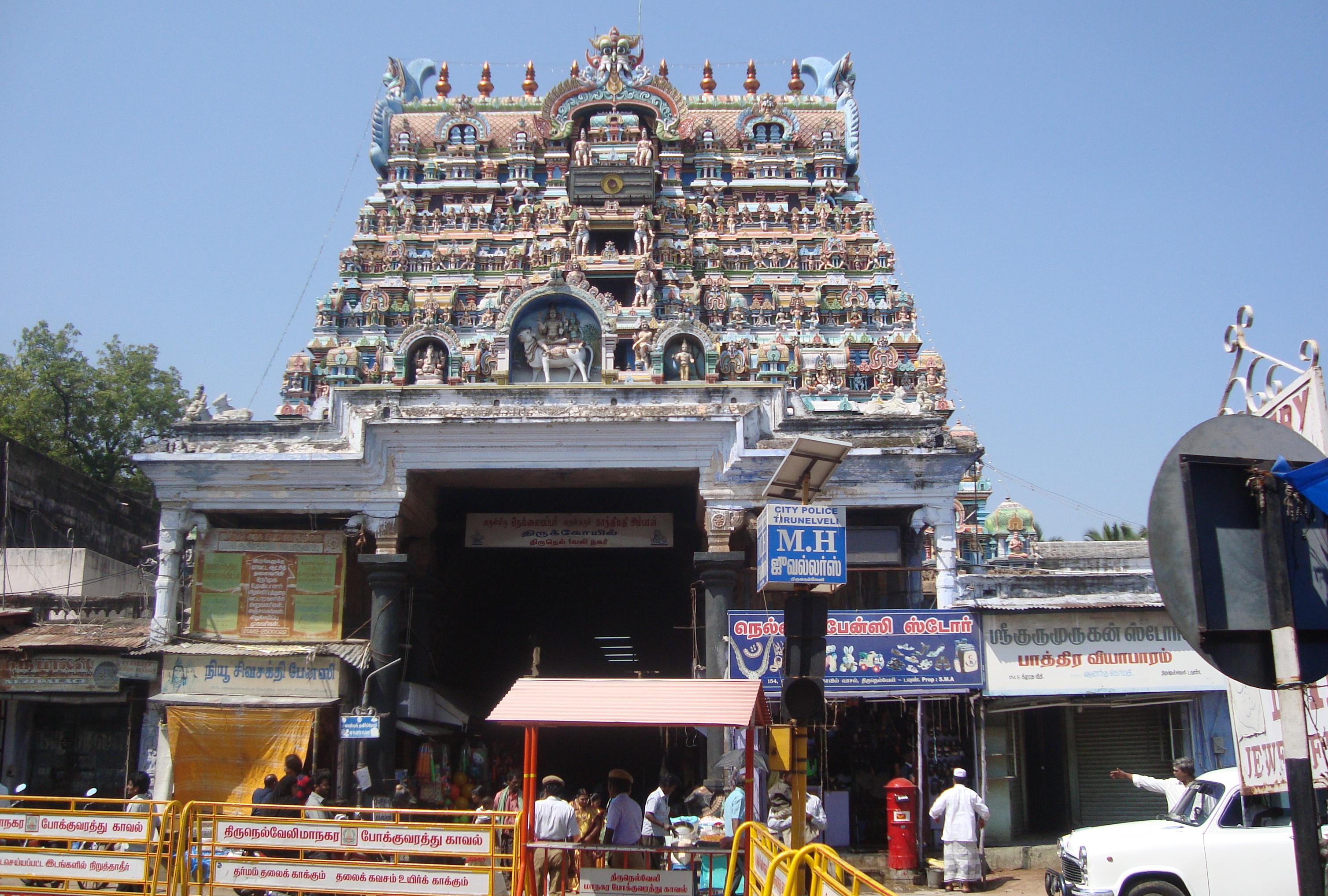
Nellaiappar temple
Manjolai Hills[]
Located between elevations ranging from 1000 to 1500 Metres, the Manjolai area is set deep within the Western Ghats within the Kalakad Mundanthurai Tiger Reserve in the Tirunelveli District. Located on top of the Manimuthar Dam & the Manimuthar Water Falls, the Manjolai area comprises Tea Plantations, Small settlements around the tea plantations; Upper Kodaiyar Dam and a windy view point called Kuthiravetti
The Tea Plantations and the whole of Manjolai Estates are tea operated by The Bombay Burmah Trading Corporation Ltd on Forest Lands leased by the Government of Tamil Nadu. There are 3 Tea Estates within the Manjolai area - Manjolai Estate, Manimutharu Estate & Oothu Estate. The Estates are located on elevations ranging between 2300 Feet to 4200 Feet. The estates, road & the settlements in the Manjolai area are managed by The Bombay Burmah Trading Corporation Ltd.
Courtallam[]
Courtallam is situated at a mean elevation of 160 m (520 ft) on the Western Ghats in Tirunelveli District of Tamil Nadu, India. The numerous waterfalls and cascades along with the ubiquitous health resorts in the area have earned it the title the Spa of South India. The falls carry a good amount of water only when there is a rain on the hills. They are Main Falls, Five Falls, the Shenbhaga Falls, the Tiger Falls, old Courtallam Falls, Honey Falls, Orchard falls and Sitraruvi.[16]
Tiger Reserve[]
The 900 square kilometres (350 sq mi) Kalakkad Mundanthurai Tiger Reserve was established in 1962. The reserve, at , is about 45 km west of Tirunelveli and is known as KMTS to forest and tiger researchers. Kalakkad is the nearest town.
Bird Sanctuary[]
A tiny village in the far south, Koonthankulam in Nanguneri Taluk of Tirunelveli District is emerging as a new favourite of the migratory birds. It is just 38 km. About 35 species of birds visit this calm but congenial village for breeding. The birds called Painted strokes are coming from North India and East European Countries to this place. Similarly the flamingoes which flew in mainly from the Rann of Kutch have hatched and reared their young ones in the village.[17]
Sankarankoil[]
Sankaran kovil temple was built in the early part of the 11th century A.D .The temple at Sankarankoil depicts Hari and Hara as one God. There is a deity named Sankara Narayanan, which is half Lord Shiva and half Lord Vishnu. There is another deity, named Avodai ambal or Gomathi Ambal, after whom the temple is named; it was built by Ukrama Pandiyan in 900 AD. Sacred sand is available, which is believed curative by some. June is marked by the Adi Thabasu festival. [18]
Swamy Nellaiappar and Kanthimathi Ambal Temple[]
The Nellaiappar Temple, a well-known temple in Tamil Nadu, is located at Tirunelveli. The temple is rooted in tradition and history, and known for its musical pillars and other sculpted figures.[19] The nearest airport is Tuticorin Airport (TCR) at Vagaikulam, a 30-minute drive (32 km) from Tirunelveli .[20]
Notable People From Tirunelveli District[]
List of notable people from Tirunelveli district
References[]
- ^ "2011 Census of India" (Excel). Indian government. 16 April 2011. http://www.censusindia.gov.in/2011-prov-results/prov_data_products_tamilnadu.html.
- ^ http://www.edreamsinetcafe.in/tirunelveli/history.htm
- ^ http://www.dictirunelveli.in/profile.html
- ^ [1]
- ^ "Tirunelveli District Irrigation". http://www.nellai.tn.nic.in/irrigation.html. Retrieved 2006-09-24.
- ^ a b c d e f "District Census 2011". Census2011.co.in. 2011. http://www.census2011.co.in/district.php. Retrieved 2011-09-30.
- ^ US Directorate of Intelligence. "Country Comparison:Population". https://www.cia.gov/library/publications/the-world-factbook/rankorder/2119rank.html. Retrieved 2011-10-01. "Oman 3,027,959"
- ^ "2010 Resident Population Data". U. S. Census Bureau. http://2010.census.gov/2010census/data/apportionment-pop-text.php. Retrieved 2011-09-30. "Iowa 3,046,355"
- ^ censusindiamaps
- ^ http://www.census.tn.nic.in/religion.aspx
- ^ a b c d e Microsoft Word - Format.doc
- ^ http://www.collegesintamilnadu.com/Education_News/20114/20111214c.asp
- ^ Tamil Nadu animal-husbandry report Retrieved 2011-09-15.
- ^ The Hindu Business Line : TN plans to reorient Nanguneri SEZ with Tuticorin
- ^ Nanguneri.Com India Portal
- ^ [2]
- ^ [3]
- ^ [4]
- ^ Tirunelveli District, National Informatics Centre, Tirunelveli Tourism & Places of Importance
- ^ [5]
Tenkasi is a town located in the foothills of the Western Ghats near the Courtallam Waterfalls, close to the Tamil Nadu - Kerala border in Tirunelveli District, Images of Tenkasi can be viewed at http://www.flickr.com/photos/59865572@N00/sets/72157627474577956/
External links[]

|
Idukki district, Kerala | Virudhunagar district |
| |
| Pathanamthitta district, Kerala Kollam district, Kerala |
Thoothukudi district | |||
 Tirunelveli district | ||||
| Thiruvananthapuram district, Kerala Kanniyakumari district |
Gulf of Mannar |
Template:Tirunelveli district
| ||||||||||||||||||||||||||||||||||||||||
| This page uses content from the English language Wikipedia. The original content was at Tirunelveli district. The list of authors can be seen in the page history. As with this Familypedia wiki, the content of Wikipedia is available under the Creative Commons License. |