| ||||||||||||||
| Lauderdale County, Tennessee | |
 Lauderdale County Courthouse in Ripley
| |
Location in the state of Tennessee | |
 Tennessee's location in the U.S. | |
| Founded | 1835 |
|---|---|
| Named for | James Lauderdale[1] |
| Seat | Ripley |
| Largest city | Ripley |
| Area - Total - Land - Water |
508 sq mi (1,316 km²) 472 sq mi (1,222 km²) 36 sq mi (93 km²), 7.0% |
| Population - (2020) - Density |
25,143 59/sq mi (23/km²) |
| Congressional district | 8th |
| Time zone | Central: UTC-6/-5 |
| Website | https://lauderdalecountytn.org/ |
Lauderdale County is a county located on the western edge of the U.S. state of Tennessee, with its border the Mississippi River. As of the 2020 census, the population was 25,143. Its county seat is Ripley.[2] Since the antebellum years, it has been developed for cotton as a major commodity crop.
History[]
Lauderdale County was created in 1835 from parts of Tipton, Dyer and Haywood counties. It was named for Lieutenant Colonel James Lauderdale, who was killed at the Battle of New Orleans in the War of 1812.[1] Planters developed large cotton plantations along the waterways, and used enslaved African Americans in gangs to work and process this commodity crop. After the American Civil War, many freedmen initially stayed in the area, working the land as sharecroppers or tenant farmers. Whites used violence to enforce white supremacy after the war, continuing after Reconstruction. In the period after Reconstruction and into the early 20th century, whites in Lauderdale County committed eight lynchings of blacks. This was the fifth-highest total of any county in the state, but three other counties also had eight lynchings each in this period.[3]
Battle of Fort Pillow[]
In 1861, the Confederate States Army built extensive defensive fortifications in Lauderdale County along the Mississippi River and named the site for General Gideon J. Pillow. Because of its strategic location, the fort was taken over by the Union Army in 1864, which had occupied the state since 1862.
In 1864, Confederates attacked and overran the fort's Union defenders, who were about evenly split between white and black soldiers. They were reported to have refused to surrender, but historians have disputed this account. The Confederates gave the soldiers no quarter, and killed black soldiers in twice the proportion of white ones. After the Union Army established the United States Colored Troops (USCT), made up of numerous recruits who were escaped slaves, Southern military officials vowed to kill them rather than take them prisoner.[4] People in the North considered this event to be a massacre, and blacks in the Union Army used the cry, "Remember Fort Pillow!" to rally during the remainder of the war.
Fort Pillow State Park has a museum to interpret the battle and also has reconstructed fortifications on the original site of the fort.
Geography[]
According to the U.S. Census Bureau, the county has a total area of 508 square miles (1,320 km2), of which 472 square miles (1,220 km2) is land and 36 square miles (93 km2) (7.0%) is water.[5] The county's western boundary is formed by the Mississippi River, its northern boundary with Dyer County is formed by the Forked Deer River, and its southern boundary with Haywood County is formed by the Hatchie River.[1]
Lauderdale County is situated on the southeastern edge of the New Madrid Seismic Zone, an area with a high earthquake risk.
Adjacent counties[]
- Dyer County (north)
- Crockett County (east)
- Haywood County (southeast)
- Tipton County (south)
- Mississippi County, Arkansas (west)
National protected areas[]
- Chickasaw National Wildlife Refuge
- Lower Hatchie National Wildlife Refuge (part)
State protected areas[]
- Cold Creek Wildlife Management Area
- Fort Pillow State Park
- Alex Haley House and Museum (state historic site)
- Sunk Lake State Natural Area
- John Tully State Forest
- John Tully Wildlife Management Area
Major roads[]
- Future Interstate 69
- U.S. Highway 51
- Tennessee State Route 19 (Tina Turner Highway)
- Tennessee State Route 87
- Tennessee State Route 88
- Tennessee State Route 180
- Tennessee State Route 181
- Tennessee State Route 371
Demographics[]
| Historical populations | |||
|---|---|---|---|
| Census | Pop. | %± | |
| 1840 | 3,435 | ||
| 1850 | 5,169 | 50.5% | |
| 1860 | 7,559 | 46.2% | |
| 1870 | 10,838 | 43.4% | |
| 1880 | 14,918 | 37.6% | |
| 1890 | 18,756 | 25.7% | |
| 1900 | 21,971 | 17.1% | |
| 1910 | 21,105 | −3.9% | |
| 1920 | 21,494 | 1.8% | |
| 1930 | 23,406 | 8.9% | |
| 1940 | 24,461 | 4.5% | |
| 1950 | 25,047 | 2.4% | |
| 1960 | 21,844 | −12.8% | |
| 1970 | 20,271 | −7.2% | |
| 1980 | 24,555 | 21.1% | |
| 1990 | 23,491 | −4.3% | |
| 2000 | 27,101 | 15.4% | |
| 2010 | 27,815 | 2.6% | |
| U.S. Decennial Census[6] 1790-1960[7] 1900-1990[8] 1990-2000[9] 2010-2020[10] 2020[11] | |||
 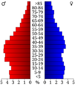 Age pyramid Lauderdale County[12] |
2020 census[]
| Race | Num. | Perc. |
|---|---|---|
| White (non-Hispanic) | 15,016 | 59.72% |
| Black or African American (non-Hispanic) | 8,385 | 33.35% |
| Native American | 133 | 0.53% |
| Asian | 53 | 0.21% |
| Other/Mixed | 969 | 3.85% |
| Hispanic or Latino | 587 | 2.33% |
As of the 2020 United States census, there were 25,143 people, 9,675 households, and 6,753 families residing in the county.
2000 census[]
As of the census[14] of 2000, there were 27,101 people, 9,567 households, and 6,811 families residing in the county. The population density was 58 people per square mile (22/km2). There were 10,563 housing units at an average density of 22 per square mile (9/km2). The racial makeup of the county was 63.82% White, 34.08% Black or African American, 0.62% Native American, 0.16% Asian, 0.02% Pacific Islander, 0.52% from other races, and 0.78% from two or more races. 1.16% of the population were Hispanic or Latino of any race.


Scenic view in Lauderdale County (2004)
There were 9,567 households, out of which 32.80% had children under the age of 18 living with them, 49.70% were married couples living together, 17.60% had a female householder with no husband present, and 28.80% were non-families. 25.60% of all households were made up of individuals, and 11.10% had someone living alone who was 65 years of age or older. The average household size was 2.55 and the average family size was 3.06.
In the county, the population was spread out, with 24.80% under the age of 18, 10.30% from 18 to 24, 31.20% from 25 to 44, 21.70% from 45 to 64, and 12.10% who were 65 years of age or older. The median age was 35 years. For every 100 females there were 108.10 males. For every 100 females age 18 and over, there were 109.00 males.
The median income for a household in the county was $29,751, and the median income for a family was $36,841. Males had a median income of $28,325 versus $21,238 for females. The per capita income for the county was $13,682. About 16.20% of families and 19.20% of the population were below the poverty line, including 24.70% of those under age 18 and 26.50% of those age 65 or over.
Culture[]
Sleepy John Estes[]
Sleepy John Estes was a U.S. blues guitarist, songwriter and vocalist, born in Ripley, Tennessee.[15] He died on June 5, 1977, in his home of 17 years in Brownsville, Haywood County, Tennessee.[16][17][18] Sleepy John is buried at Elam Baptist Church Cemetery in Durhamville, Lauderdale County.[18]
Veterans' Museum in Halls[]
The Veterans' Museum on the grounds of the former Dyersburg Army Air Base in Halls is dedicated to the preservation and documentation of materials related to military activities from World War I to the present day wars and conflicts, as well as documenting the history of the air base itself.
Government and infrastructure[]
| Year | Republican | Democratic | Third party | |||
|---|---|---|---|---|---|---|
| No. | % | No. | % | No. | % | |
| 2020 | 5,674 | 63.29% | 3,193 | 35.62% | 98 | 1.09% |
| 2016 | 4,884 | 60.39% | 3,056 | 37.79% | 147 | 1.82% |
| 2012 | 4,616 | 53.12% | 4,011 | 46.16% | 62 | 0.71% |
| 2008 | 4,933 | 52.83% | 4,322 | 46.28% | 83 | 0.89% |
| 2004 | 4,164 | 47.96% | 4,474 | 51.53% | 44 | 0.51% |
| 2000 | 3,329 | 43.70% | 4,224 | 55.45% | 65 | 0.85% |
| 1996 | 2,481 | 34.63% | 4,349 | 60.71% | 334 | 4.66% |
| 1992 | 2,928 | 36.79% | 4,452 | 55.94% | 578 | 7.26% |
| 1988 | 3,308 | 49.83% | 3,296 | 49.65% | 35 | 0.53% |
| 1984 | 3,566 | 50.23% | 3,506 | 49.39% | 27 | 0.38% |
| 1980 | 2,818 | 38.95% | 4,318 | 59.68% | 99 | 1.37% |
| 1976 | 2,105 | 30.61% | 4,747 | 69.03% | 25 | 0.36% |
| 1972 | 3,597 | 64.40% | 1,771 | 31.71% | 217 | 3.89% |
| 1968 | 1,080 | 15.99% | 2,108 | 31.21% | 3,566 | 52.80% |
| 1964 | 1,880 | 32.83% | 3,847 | 67.17% | 0 | 0.00% |
| 1960 | 1,322 | 27.36% | 3,462 | 71.65% | 48 | 0.99% |
| 1956 | 1,049 | 18.94% | 4,383 | 79.12% | 108 | 1.95% |
| 1952 | 1,390 | 24.26% | 4,340 | 75.74% | 0 | 0.00% |
| 1948 | 298 | 7.68% | 2,556 | 65.89% | 1,025 | 26.42% |
| 1944 | 381 | 9.25% | 3,732 | 90.65% | 4 | 0.10% |
| 1940 | 317 | 4.80% | 6,279 | 95.09% | 7 | 0.11% |
| 1936 | 203 | 5.41% | 3,540 | 94.27% | 12 | 0.32% |
| 1932 | 174 | 7.40% | 2,137 | 90.94% | 39 | 1.66% |
| 1928 | 430 | 13.32% | 2,798 | 86.68% | 0 | 0.00% |
| 1924 | 242 | 12.96% | 1,596 | 85.44% | 30 | 1.61% |
| 1920 | 1,190 | 33.97% | 2,313 | 66.03% | 0 | 0.00% |
| 1916 | 532 | 25.26% | 1,572 | 74.64% | 2 | 0.09% |
| 1912 | 186 | 10.18% | 1,020 | 55.83% | 621 | 33.99% |
| 1908 | 519 | 27.96% | 1,315 | 70.85% | 22 | 1.19% |
| 1904 | 168 | 5.24% | 3,017 | 94.08% | 22 | 0.69% |
| 1900 | 437 | 18.98% | 1,807 | 78.46% | 59 | 2.56% |
| 1896 | 709 | 23.69% | 2,244 | 74.97% | 40 | 1.34% |
| 1892 | 967 | 33.55% | 1,218 | 42.26% | 697 | 24.18% |
| 1888 | 1,433 | 43.48% | 1,838 | 55.76% | 25 | 0.76% |
| 1884 | 1,330 | 46.34% | 1,488 | 51.85% | 52 | 1.81% |
| 1880 | 971 | 44.04% | 1,147 | 52.02% | 87 | 3.95% |
The Tennessee Department of Corrections operates the West Tennessee State Penitentiary in unincorporated Lauderdale County, near Henning.[20] Previously the Cold Creek Correctional Facility was located in the area.[21]
Communities[]


A-7 Corsair II in front of the Veterans' Museum in Halls (2006)

Alex Haley's boyhood home in Henning (2007)
City[]
- Ripley (county seat)
Town[]
- Gates
- Halls
- Henning
Unincorporated communities[]
- Arp
- Cherry
- Durhamville
- Fulton
- Glimp
- Golddust
- Orysa
Notable natives[]
- Sleepy John Estes, blues guitarist born in Ripley
- Alex Haley - author of Roots
- Jim Hickman - Professional Baseball All-Star
- Miles O'Keeffe, television and film actor best known for starring in the 1981 film Tarzan, the Ape Man, and the Ator movies.
See also[]
- National Register of Historic Places listings in Lauderdale County, Tennessee
References[]
- ^ a b c Ann Toplovich, "Lauderdale County," Tennessee Encyclopedia of History and Culture. Retrieved: 21 October 2013.
- ^ "Find a County". National Association of Counties. http://www.naco.org/Counties/Pages/FindACounty.aspx.
- ^ Lynching in America, Third Edition: Supplement by County Archived 2017-10-23 at the Wayback Machine, p. 9, Equal Justice Initiative, Mobile, AL, 2017
- ^ John Cimprich and Robert C. Mainfort, Jr., "Fort Pillow Revisited", 1982, in Race and Recruitment, ed. John David Smith, Kent State University Press, 2013, p. 214
- ^ "2010 Census Gazetteer Files". United States Census Bureau. August 22, 2012. http://www2.census.gov/geo/docs/maps-data/data/gazetteer/counties_list_47.txt.
- ^ "U.S. Decennial Census". United States Census Bureau. https://www.census.gov/programs-surveys/decennial-census.html.
- ^ "Historical Census Browser". University of Virginia Library. http://mapserver.lib.virginia.edu.
- ^ Forstall, Richard L., ed (March 27, 1995). "Population of Counties by Decennial Census: 1900 to 1990". United States Census Bureau. https://www.census.gov/population/cencounts/tn190090.txt.
- ^ "Census 2000 PHC-T-4. Ranking Tables for Counties: 1990 and 2000". United States Census Bureau. April 2, 2001. https://www.census.gov/population/www/cen2000/briefs/phc-t4/tables/tab02.pdf.
- ^ "State & County QuickFacts". United States Census Bureau. http://quickfacts.census.gov/qfd/states/47/47097.html.
- ^ "2020 Census Data". https://data.census.gov/cedsci/profile?g=0500000US47097.
- ^ Based on 2000 census data
- ^ "Explore Census Data". https://data.census.gov/cedsci/table?g=0500000US47097&tid=DECENNIALPL2020.P2.
- ^ "U.S. Census website". United States Census Bureau. https://www.census.gov.
- ^ Biography at 7digital.com from the Encyclopedia of Popular Music - accessed February 2008 Archived 2008-06-05 at the Wayback Machine
- ^ Bob Koester and Ray Harmon, Sleepy John Estes Archived 2009-01-18 at the Wayback Machine, All About Jazz. Retrieved: 17 February 2013.
- ^ Brian Dempsey. "'Sleepy' John Estes". Tennessee Encyclopedia of History and Culture. Tennessee Historical Society. http://tennesseeencyclopedia.net/entry.php?rec=1593.
- ^ a b Norris, Sharon (2000). Black America Series: Haywood County Tennessee. Mount Pleasant, SC: Arcadia Publishing. ISBN 0-7385-0605-2.
- ^ Leip, David. "Dave Leip's Atlas of U.S. Presidential Elections". http://uselectionatlas.org/RESULTS.
- ^ "West Tennessee State Penitentiary." Tennessee Department of Correction. Retrieved on September 26, 2010.
- ^ "Cold Creek Correctional Facility." Tennessee Department of Correction. February 3, 1999. Updated July 13, 1998. Retrieved on September 26, 2010.
External links[]
- The Lauderdale County Home Page
- Lauderdale Chamber / Economic and Community Development
- Lauderdale County, TNGenWeb - free genealogy resources for the county
- Lauderdale County at Curlie
- Lauderdale County Department of Education

|
Dyer County |
| ||
| Mississippi County, Arkansas | Crockett County | |||
 Lauderdale County, Tennessee | ||||
| Tipton County | Haywood County |
Template:Lauderdale County, Tennessee
|
| This page uses content from the English language Wikipedia. The original content was at Lauderdale County, Tennessee. The list of authors can be seen in the page history. As with this Familypedia wiki, the content of Wikipedia is available under the Creative Commons License. |