| ||||||||||||||
| Beaver County, Utah | |
 Location in the state of Utah | |
 Utah's location in the U.S. | |
| Founded | 1856 |
|---|---|
| Named for | North American Beaver |
| Seat | Beaver |
| Largest city | Beaver |
| Area - Total - Land - Water |
2,592 sq mi (6,713 km²) 2,590 sq mi (6,708 km²) 2.1 sq mi (5 km²), 0.08% |
| Population - (2010) - Density |
6,629 2.5/sq mi (1/km²) |
| Congressional district | 2nd |
| Time zone | Mountain: UTC-7/-6 |
| Website | beaver.utah.gov |
Beaver County (UT) Details
Beaver County is a county located in the U.S. state of Utah. As of the 2010 census, the population was 6,629.[1] Its county seat and largest city is Beaver.[2] The county was named for the abundance of beavers in the area.
History[]
While explorers first visited present-day Beaver County in the 1776 Dominguez-Escalante Expedition, the county was created by the Utah territorial legislature from a section of Iron County on January 5, 1856 when Mormon settlers founded the city of Beaver, Utah. The county was named after the animal which was plentiful there.[3]
Geography[]
According to the U.S. Census Bureau, the county has a total area of 2,592 square miles (6,710 km2), of which 2,590 square miles (6,700 km2) is land and 2.1 square miles (5.4 km2) (0.08%) is water.[4] The Tushar Mountains lie on the eastern boundary of the county, reaching to 12,000 feet (3,700 m) in elevation, and providing water for the farming communities of Beaver and Manderfield. To the west, barren desert valleys typify the scenery, separated by mountains lightly forested with junipers.
Adjacent counties[]
- Lincoln County, Nevada (west)
- Millard County, Utah (north)
- Iron County, Utah (south)
- Sevier County, Utah (east)
- Piute County, Utah (east)
National protected area[]
- Fishlake National Forest (part)
Demographics[]
| Historical populations | |||
|---|---|---|---|
| Census | Pop. | %± | |
| 1860 | 785 | ||
| 1870 | 2,007 | 155.7% | |
| 1880 | 3,918 | 95.2% | |
| 1890 | 3,340 | −14.8% | |
| 1900 | 3,613 | 8.2% | |
| 1910 | 4,717 | 30.6% | |
| 1920 | 5,139 | 8.9% | |
| 1930 | 5,136 | −0.1% | |
| 1940 | 5,014 | −2.4% | |
| 1950 | 4,856 | −3.2% | |
| 1960 | 4,331 | −10.8% | |
| 1970 | 3,800 | −12.3% | |
| 1980 | 4,378 | 15.2% | |
| 1990 | 4,765 | 8.8% | |
| 2000 | 6,005 | 26.0% | |
| 2010 | 6,629 | 10.4% | |
| Est. 2012 | 6,501 | 8.3% | |
1790-1960[6] 1900-1990[7] 1990-2000[8] 2010-2012[1] | |||
As of the census[9] of 2010, there were 6,629 people, 2,265 households, and 1,697 families residing in the county. The population density was 2.56 people per square mile (1/km²). There were 2,908 housing units at an average density of 1.12 per square mile (0.43/km²). The racial makeup of the county was 89% White, 0.24% Black or African American, 1.14% Native American, 1.05% Asian, 0.28% Pacific Islander, 6.86% from other races, and 1.4% from two or more races. 10.8% of the population were Hispanic or Latino of any race.
There were 2,265 households out of which 32.05% had children under the age of 18 living with them, 63.22% were married couples living together, 7.2% had a female householder with no husband present, and 25.08% were non-families. 22.12% of all households were made up of individuals and 9.62% had someone living alone who was 65 years of age or older. The average household size was 2.92 and the average family size was 3.44.
The county population was spread out with 36.72% under the age of 20, 4.21% from 20 to 24, 24.09% from 25 to 44, 22.43% from 45 to 64, and 12.55% who were 65 years of age or older. The median age was 31.9 years. For every 100 females there were 106.00 males. For every 100 females age 18 and over, there were 105.93 males.
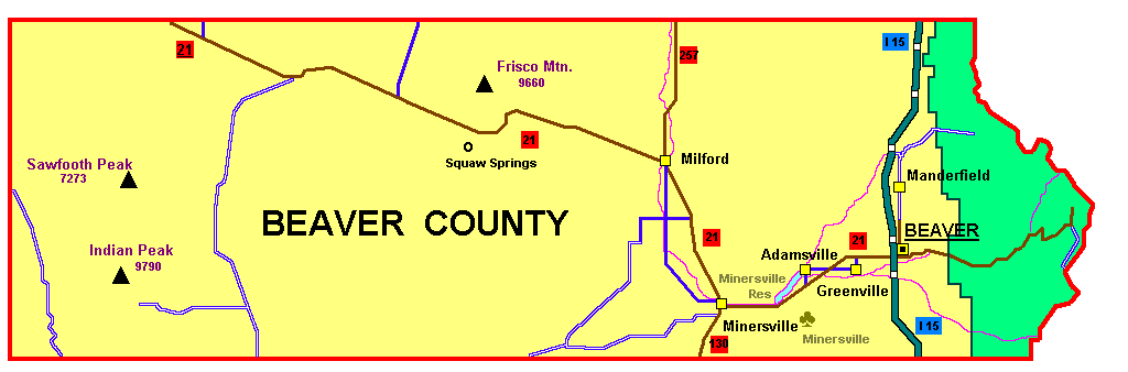
Communities[]


Map of Beaver County municipalities
- Adamsville
- Beaver
- Greenville
- Manderfield
- Milford
- Minersville
See also[]
- National Register of Historic Places listings in Beaver County, Utah
References[]
- ^ a b "State & County QuickFacts". United States Census Bureau. http://quickfacts.census.gov/qfd/states/49/49001.html. Retrieved December 29, 2013.
- ^ "Find a County". National Association of Counties. http://www.naco.org/Counties/Pages/FindACounty.aspx. Retrieved 2011-06-07.
- ^ Van Cott, J. W., 1990, Utah Place Names, ISBN 0-87480-345-4
- ^ "US Gazetteer files: 2010, 2000, and 1990". United States Census Bureau. 2011-02-12. http://www.census.gov/geo/www/gazetteer/gazette.html. Retrieved 2011-04-23.
- ^ "U.S. Decennial Census". United States Census Bureau. http://www.census.gov/prod/www/decennial.html. Retrieved December 29, 2013.
- ^ "Historical Census Browser". University of Virginia Library. http://mapserver.lib.virginia.edu. Retrieved December 29, 2013.
- ^ "Population of Counties by Decennial Census: 1900 to 1990". United States Census Bureau. http://www.census.gov/population/cencounts/ut190090.txt. Retrieved December 29, 2013.
- ^ "Census 2000 PHC-T-4. Ranking Tables for Counties: 1990 and 2000". United States Census Bureau. http://www.census.gov/population/www/cen2000/briefs/phc-t4/tables/tab02.pdf. Retrieved December 29, 2013.
- ^ "American FactFinder". United States Census Bureau. http://factfinder2.census.gov. Retrieved 2011-05-14.
- Murphy, Miriam B. (1994), "Beaver County", in Powell, Allan Kent, Utah History Encyclopedia, Salt Lake City, Utah: University of Utah Press, ISBN 0874804256, OCLC 30473917, http://www.uen.org/utah_history_encyclopedia/b/BEAVER_COUNTY.html
External links[]

|
Millard County |
| ||
| Sevier County | ||||
 Beaver County | ||||
| Iron County | Piute County |
| ||||||||||||||||||||

| |||||||||||||||||||||||
| This page uses content from the English language Wikipedia. The original content was at Beaver County, Utah. The list of authors can be seen in the page history. As with this Familypedia wiki, the content of Wikipedia is available under the Creative Commons License. |