| Main | Births etc |
|---|
| Falmouth, Massachusetts | |||
|---|---|---|---|
| — Town — | |||
 |
|||
|
|||
 |
|||
| Coordinates: Coordinates: | |||
| Country | United States | ||
| State | Massachusetts | ||
| County | Barnstable | ||
| Settled | 1660 | ||
| Incorporated | 1686 | ||
| Government | |||
| • Type | Representative town meeting | ||
| • Town Manager |
Julian M. Suso[1] | ||
| Area | |||
| • Total | 54.4 sq mi (141.0 km2) | ||
| • Land | 44.1 sq mi (114.1 km2) | ||
| • Water | 10.3 sq mi (26.8 km2) | ||
| Elevation | 10 ft (3 m) | ||
| Population (2010) | |||
| • Total | 31,531 | ||
| • Density | 715/sq mi (276.2/km2) | ||
| Time zone | Eastern (UTC-5) | ||
| • Summer (DST) | Eastern (UTC-4) | ||
| ZIP code | 02540 | ||
| Area code(s) | 508 / 774 | ||
| FIPS code | 25-23105 | ||
| GNIS feature ID | 0618253 | ||
| Website | falmouthmass.us | ||
Falmouth (pronunciation: /ˈfælmᵻθ/ FAL-mith) is a town in Barnstable County, Massachusetts, United States; Barnstable County is coextensive with Cape Cod. The population was 31,532 at the 2010 census,[2] making Falmouth the second-largest municipality on Cape Cod after Barnstable. The terminal for the Steamship Authority ferries to Martha's Vineyard is located in the village of Woods Hole in Falmouth. Woods Hole also contains several scientific organizations such as the Woods Hole Oceanographic Institution, the Marine Biological Laboratory (MBL), the Woods Hole Research Center, the Woods Hole Science Aquarium, and the scientific institutions' various museums.
For geographic and demographic information on specific parts of the town of Falmouth, please see the articles on East Falmouth, Falmouth Village, North Falmouth, Teaticket, West Falmouth, and Woods Hole. Falmouth also encompasses the villages of Hatchville and Waquoit, which are not census-designated places and fall within the village of East Falmouth based on postal service.
History[]
Falmouth was first settled by English colonists in 1660 and was officially incorporated in 1686. Bartholomew Gosnold named the settlement for Falmouth, Cornwall, England,[3] his home port. Early principal activities were farming, salt works, shipping, whaling, and sheep husbandry, which was very popular due to the introduction of Merino sheep and the beginnings of water-powered mills that could process the wool. In 1837, Falmouth averaged about 50 sheep per square mile.
Falmouth saw brief action in the War of 1812, when the area around Falmouth Heights, on its southern coast, was bombarded by several British frigates and ships of the line, and Massachusetts militia hastily entrenched themselves on the beaches to repulse a possible British landing which never came. By 1872, the train had come to Falmouth and Woods Hole, and some of the first summer homes were established. By the late 19th century, cranberries were being cultivated and strawberries were being raised for the Boston market. Large-scale dairying was tried in the early 20th century in interior regions. After the improvement in highways, and thanks in part to the heavy use of neighboring Otis Air National Guard Base during World War II, population growth increased significantly. Large homebuilding booms occurred in the 1970s, followed by others in the 1980s and 1990s.
In the late 1800s, after railroad service was established between Boston and Cape Cod, James Madison Beebe bought over 700 acres (280 ha) and built Highfield Hall, which is now a museum, and much of the land is preserved as Beebe Woods.
In 1965, Robert Manry sailed from Falmouth aboard his 13.5-foot (4.1 m) sailboat and reached Falmouth, England, 78 days later.
Historic districts[]
The town of Falmouth has seven historic districts, including four on the National Register of Historic Places:
- Falmouth Village Green
- North Falmouth Village
- Waquoit
- West Falmouth Village[4]
The other three historic districts are in Woods Hole, Davisville, and Quissett.
In addition to the historic districts, Falmouth has ten individual sites on the National Register:
- Central Fire Station
- Crowell-Bourne Farm
- Elnathan Nye House
- Falmouth Pumping Station
- Josiah Tobey House
- Lawrence Academy
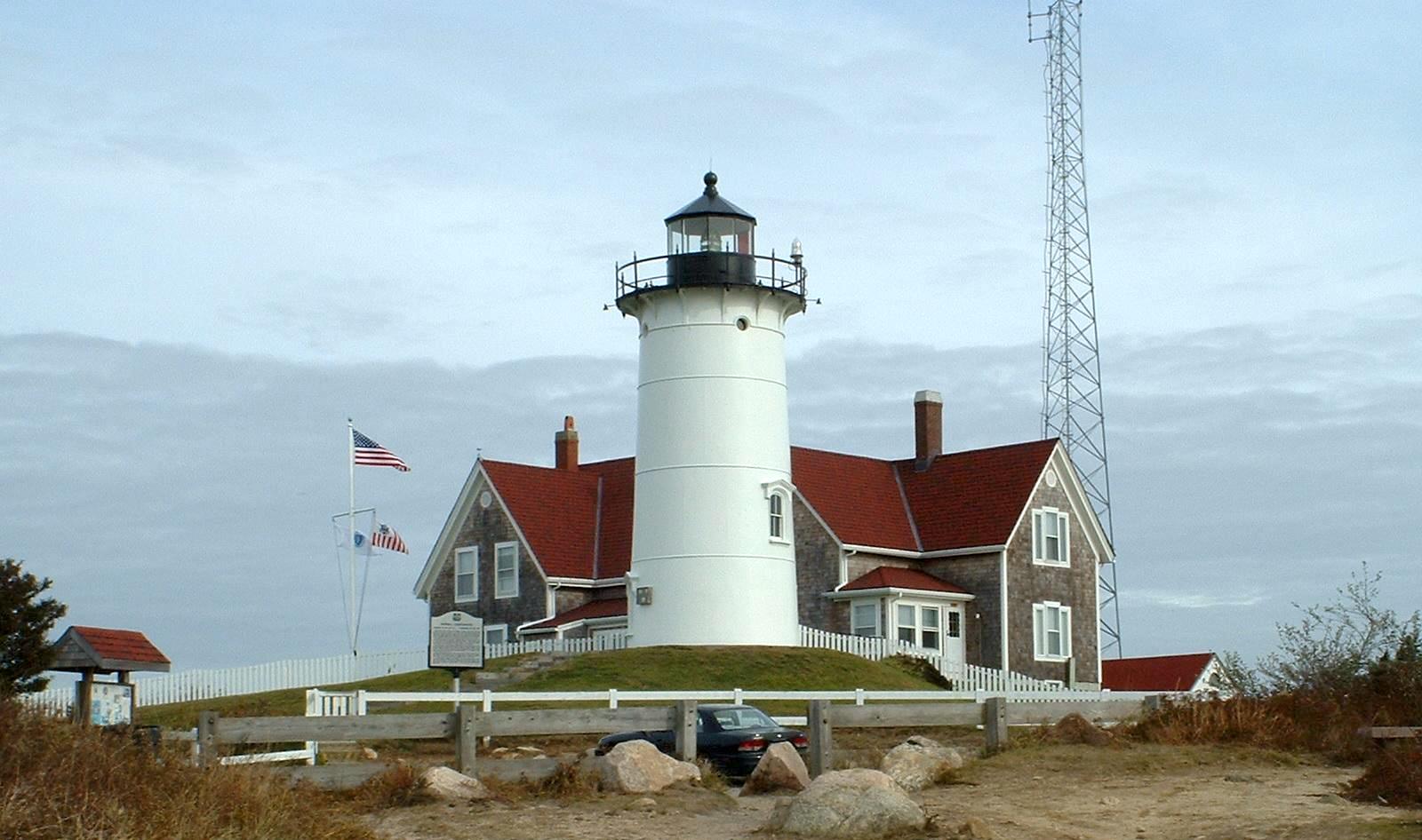
- Nobska Light
- Poor House and Methodist Cemetery
- Teaticket School
- Woods Hole School[5]
Offshore Falmouth in Buzzards Bay, Cleveland East Ledge Light is listed with the National Register.
Geography[]
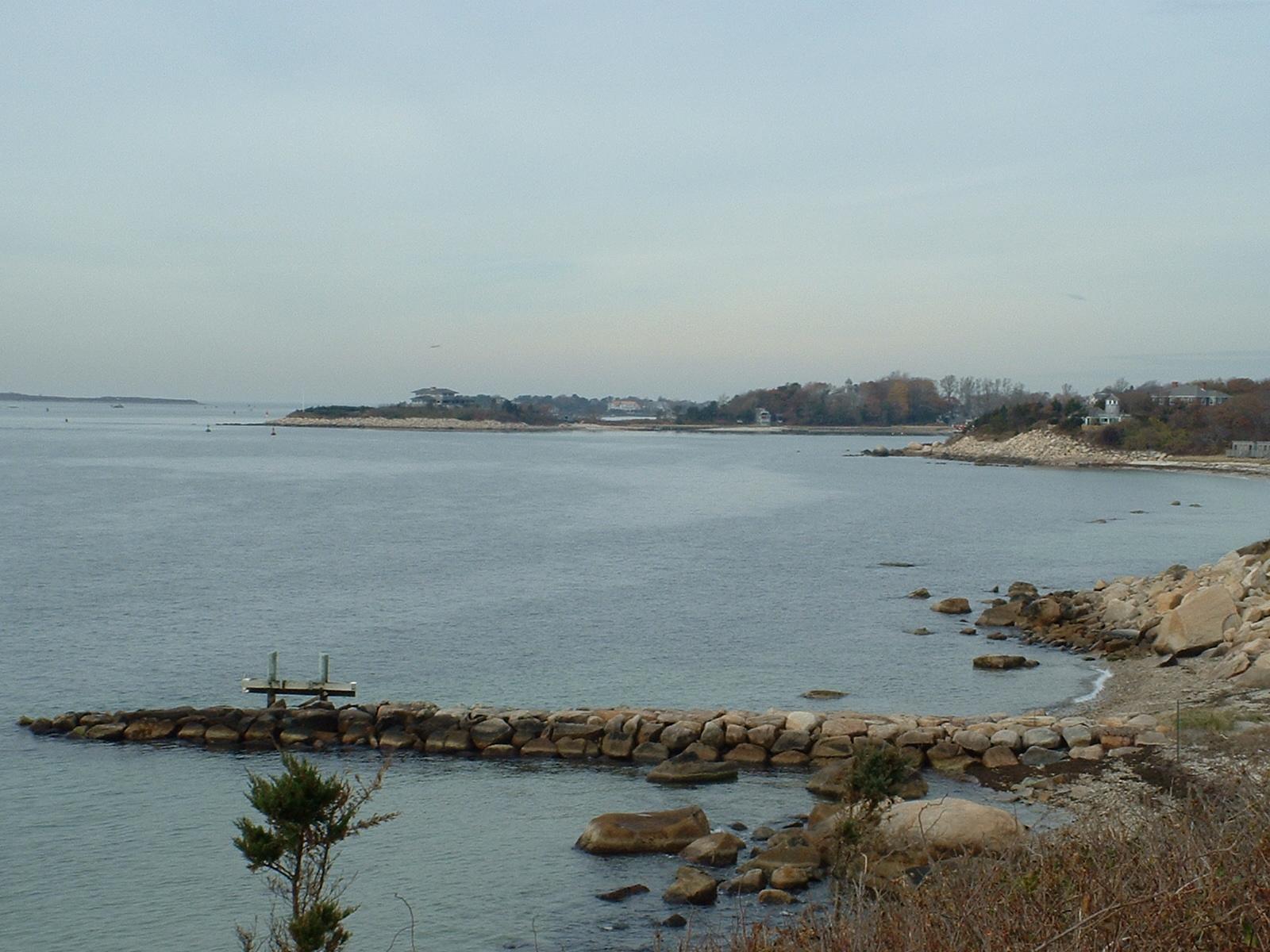
Juniper Point, the eastern point of Woods Hole in Falmouth
According to the United States Census Bureau, the town has a total area of 54.4 square miles (141.0 km2), of which 44.1 square miles (114.1 km2) is land and 10.3 square miles (26.8 km2), or 19.04%, is water.[2] Most of Falmouth, like the rest of Cape Cod, sits on glacial sands composed of glacial outwash deposits. However, the soil in the southwestern part of the town, consisting of moraine deposits, is more rocky and dense, like the rest of New England, and many glacial erratics are scattered about, having been dropped by the retreating glaciers. The climate is temperate marine. There is no exposed bedrock. Rainfall is evenly distributed throughout the year and averages 2 to 3 in (50 – 75 mm) per month.
Falmouth lies on the southwestern tip of Cape Cod. It is bordered by Bourne and Sandwich to the north, Mashpee to the east, Vineyard Sound to the south, and Buzzards Bay to the west. At its closest point, Falmouth is approximately 560 yards (510 m) from Nonamesset Island, the easternmost island of the town of Gosnold and the Elizabeth Islands. It is approximately 3+13⁄{{{4}}} miles (5.4 km) north-northwest of Martha's Vineyard, the closest land to the island. Falmouth is approximately 14 miles (23 km) south of the Bourne Bridge, 22 miles (35 km) west of Barnstable, and 77 miles (124 km) south-southeast of Boston.
Falmouth's topography is similar to the rest of Cape Cod's, with many small ponds, creeks, and inlets surrounded by the pines and oaks of the Cape and often rocky beachfront. Falmouth's southern shore is notable for a series of ponds and rivers spaced very closely together, all of which travel some distance into the town. These include, from west to east, Falmouth Inner Harbor, Little Pond, Great Pond (which leads to the Dexter and Coonamesset rivers), Green Pond, Bourne's Pond, Eel Pond (which leads to the Childs River), and Waquoit Bay, which lies along the Mashpee town line. The Buzzards Bay side of the town is primarily bays divided by necks, peninsulas connected to land by isthmi. The largest inlet is Megansett Cove along the Bourne town line. The Buzzards Bay shore of Falmouth is punctuated by a number of hamlets, including, from north to south, Megansett, New Silver Beach, Old Silver, Chappaquoit, Sippewisset, Quissett, and Woods Hole.
Transportation[]

Falmouth's main road is Massachusetts Route 28, which runs south from Bourne as a divided highway, then becomes a surface road and heads east through downtown as Main Street, then turns northeast through East Falmouth before crossing into Mashpee. As one of two major east–west routes on the Cape, Route 28 is regularly congested, and there is minimal room for widening opportunities. Route 151 runs east–west through the northern section of the town, connecting North Falmouth and Hatchville with Mashpee.
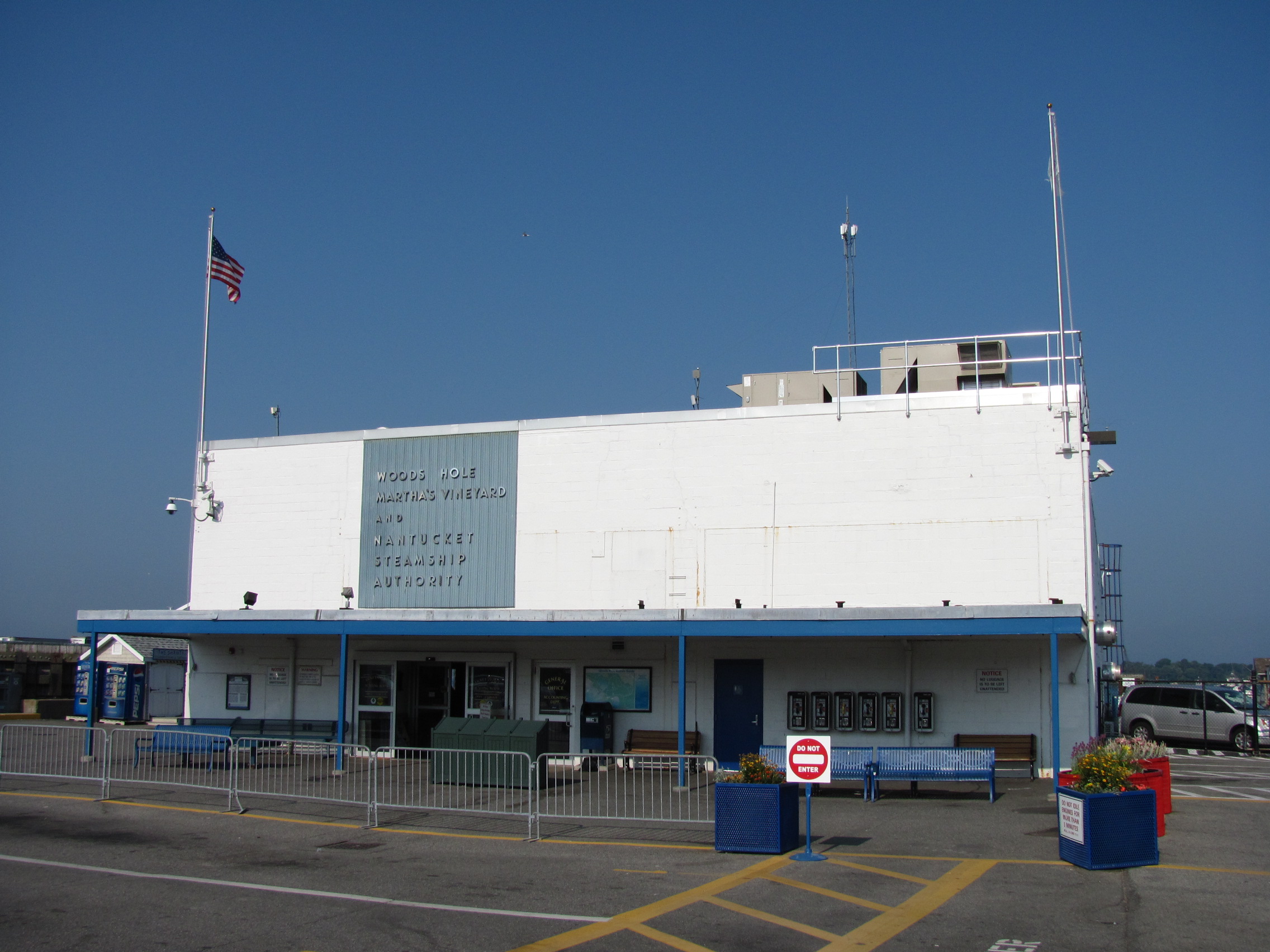
Falmouth is home to The Woods Hole, Martha's Vineyard and Nantucket Steamship Authority. Daily ferry service brings tourists, residents and supplies from Woods Hole to Nantucket and Martha's Vineyard. It is the main ferry line between the Vineyard and the mainland (as Nantucket is further east, its main line leaves Hyannis). A seasonal ferry, the Island Queen, runs from Falmouth Harbor to Martha's Vineyard.
The Massachusetts Coastal Railroad provides rail freight service to North Falmouth, where a spur runs into Otis Air Base to serve a trash transfer station. Also, as of a June 25, 2009 capecodonline.com article, the company plans to re-extend passenger railroad service to the town, complete with dinner and tourist trains, though this will also be only to North Falmouth, due to the fact that the other 8 miles (13 km) of railroad track had been replaced with the current Shining Sea Bikeway. On November 21, 2009, North Falmouth saw its first passenger train in at least 12 years. The nearest inter-city (Amtrak) passenger rail stations are Providence and Boston's South Station. The Middleborough/Lakeville and Kingston/Route 3 stations of the MBTA's commuter rail system provide the closest service to Boston.
There is a private air park in East Falmouth,[6] and the nearest national and international air service is at Logan International Airport in Boston. There is a regional airport in nearby Hyannis.
Falmouth is also served by the Cape Cod Regional Transit Authority bus routes.
Demographics[]
| Historical population | ||
|---|---|---|
| Year | Pop. | ±% |
| 1850 | 2,621 | — |
| 1860 | 2,456 | −6.3% |
| 1870 | 2,237 | −8.9% |
| 1880 | 2,422 | +8.3% |
| 1890 | 2,567 | +6.0% |
| 1900 | 3,500 | +36.3% |
| 1910 | 3,144 | −10.2% |
| 1920 | 3,500 | +11.3% |
| 1930 | 4,821 | +37.7% |
| 1940 | 6,878 | +42.7% |
| 1950 | 8,662 | +25.9% |
| 1960 | 13,037 | +50.5% |
| 1970 | 15,942 | +22.3% |
| 1980 | 23,640 | +48.3% |
| 1990 | 27,960 | +18.3% |
| 2000 | 32,660 | +16.8% |
| 2010 | 31,531 | −3.5% |
As of the census[17] of 2000, there were 32,660 people, 13,859 households, and 8,980 families residing in the town. The population density was 738.2 inhabitants per square mile (285.0 /km2). There were 20,055 housing units at an average density of 453.3 per square mile (175.0 /km2). The racial makeup of the town was 93.39% White, 1.82% Black or African American, 0.51% Native American, 0.92% Asian, 0.02% Pacific Islander, 1.44% from other races, and 1.91% from two or more races. Hispanic or Latino of any race were 1.28% of the population.
There were 13,859 households out of which 24.2% had children under the age of 18 living with them, 52.0% were married couples living together, 10.1% had a female householder with no husband present, and 35.2% were non-families. 29.8% of all households were made up of individuals and 14.0% had someone living alone who was 65 years of age or older. The average household size was 2.30 and the average family size was 2.84.
In the town, the population was spread out with 20.7% under the age of 18, 4.8% from 18 to 24, 24.5% from 25 to 44, 27.5% from 45 to 64, and 22.5% who were 65 years of age or older. The median age was 45 years. For every 100 females there were 87.6 males. For every 100 females age 18 and over, there were 83.9 males.
The median income for a household in the town was $48,191, and the median income for a family was $57,422. Males had a median income of $41,797 versus $28,867 for females. The per capita income for the town was $27,548. About 4.5% of families and 6.9% of the population were below the poverty line, including 8.8% of those under age 18 and 6.2% of those age 65 or over.
Government[]
Falmouth is represented in the Massachusetts House of Representatives as a part of two districts, the Third Barnstable (which also includes portions of Barnstable, Bourne and Mashpee), and the Barnstable, Dukes and Nantucket District, which includes all of Martha's Vineyard, Nantucket and Gosnold. The town is represented in the Massachusetts Senate as a part of the Plymouth and Barnstable district, which includes Bourne, Kingston, Pembroke, Plymouth, Plympton, Sandwich and portions of Barnstable.[18] The town is patrolled by the Seventh (Bourne) Barracks of Troop D of the Massachusetts State Police.[19]
On the national level, Falmouth is a part of Massachusetts's 9th congressional district, and is currently represented by Bill Keating.
Falmouth is governed by the representative town meeting form of government with 9 precincts of 27 members each serving three-year terms and is led by a five-member board of selectmen serving rotating three-year terms. The town operates its own police and fire departments, with a central police station and five fire stations. The fire department also operates the town's ambulance service with four-ambulances staffed 24/7. The town's central library is located downtown. There are branches in North and East Falmouth, and private libraries in West Falmouth and Woods Hole which are open to the public. There are seven post offices in town for the six ZIP codes, although several overlap and the main office handles the majority of the work. Falmouth is also the site of Falmouth Hospital, which serves the Upper Cape region.
Education[]
Falmouth's public school system serves about 4,500 students yearly. There are four schools, East Falmouth, Mullen-Hall, North Falmouth, and Teaticket, which serve the elementary school population, from pre-kindergarten to fourth grade. The Morse Pond Middle School serves grades five and six, while the Lawrence Junior High School serves grades seven and eight. Falmouth High School covers grades 9-12. (Prior to 1974 the 9-12 grades were in the Lawrence building and known as Lawrence High School.) FHS's athletics teams are nicknamed the Clippers, and their colors are maroon and white. They compete in the Atlantic Coast League, having moved recently from the Old Colony League. Their chief rival is nearby Barnstable High School. The public schools are supported in part by the Volunteers in Public Schools (VIPS), various PTO associations, the Falmouth Scholarship Association, the Falmouth Education Foundation (FEF), the Falmouth STEM Boosters and the Woods Hole Science Technology Partnership.
Falmouth is also the home of a private school, Falmouth Academy, serving grades 7 through 12. Falmouth high school students may also choose to attend the Upper Cape Cod Regional Technical High School in Bourne free of charge. Resident students can also attend Sturgis Charter Public School in Hyannis also free of charge, pending acceptance through a lottery.
Sports and recreation[]
The Falmouth Commodores of the Cape Cod Baseball League play at Arnie Allen Diamond at Guv Fuller Field from mid-June to early August.
Falmouth is the home of its namesake Falmouth Road Race, an annual race started in 1973 that draws over 10,000 runners from all over the world. The race runs 7 miles (11 km) from the village of Woods Hole to Falmouth Heights Beach in downtown Falmouth.
Arts and entertainment[]
Falmouth is home to a vibrant theatre community. The College Light Opera Company has performed at the Highfield Theatre every summer since 1969. Other institutions include the Falmouth Theatre Guild and the Cape Cod Theatre Project.
In addition to theatre, there is the Cape Cod Conservatory and the Falmouth Arts Guild.
Falmouth holds a yearly Christmas parade in the month of December that runs along Main Street in downtown Falmouth.
Notable people[]
- Peter Abrahams, author
- Casey Affleck, actor
- Katharine Lee Bates, author of "America the Beautiful"
- Jamaal Branch, former NFL football player for the New Orleans Saints, attended Colgate University, 2003 Walter Payton Award winner.
- Steve Cishek, relief pitcher for the Seattle Mariners
- Jim Connors, radio personality
- Colleen Coyne, 1998 Olympic gold medalist on the U.S. women's ice hockey team
- Wesley Dennis (illustrator), illustrator of children's books
- Jessica Dubroff, 7-year-old pilot trainee who died in a plane crash
- Jacob Sloat Fassett, U.S. congressman from Elmira, New York; Fassett's Point in West Falmouth and the town of Fassett, Quebec, are named after him
- Melissa Febos, writer and ex-dominatrix
- Paul Harney, former professional PGA golfer, resided in Falmouth and owned the Paul Harney Golf Club in Hatchville
- Frederick E. Olmsted, WPA muralist and sculptor then later scientist
- Bill Polian, president of the Indianapolis Colts, spends his summers in Falmouth
- Sunita Williams, astronaut and United States Navy officer
Military installations[]
Camp Edwards, formerly named Camp Falmouth, is a US military training camp in western Barnstable County. It is the largest part of Joint Base Cape Cod, formerly named Massachusetts Military Reservation. The installation is of economic and environmental importance.
Groundwater pollution[]
During the 1970s and 1980s, it was discovered that the ground water in some areas of Falmouth had been contaminated by toxic chemicals linked to the disposal of jet fuel, solvents, industrial chemicals, and other substances on the Massachusetts Military Reservation, now known as Joint Base Cape Cod. Plumes of groundwater pollution that reached into Falmouth contaminated household well water in some neighborhoods and forced the town to shut down a public well in 1975 that accounted for 25% of the town's public water supply. A major report was released on the contamination in 1986. In 1996, the Air Force Center for Environmental Excellence (now known as the Air Force Center for Engineering and the Environment) assumed responsibility for the cleanup, treating soils at several sites and installing pumping wells in an effort to contain the plumes of groundwater contamination.[20]
In 2010, the Silent Spring Institute tested about 20 public water supplies, 40 percent of which had detectable levels of perfluorinated compounds (PFCs).[21] In 2015, the Air Force started testing private wells in the Currier Road area after water treatment plant samples showed elevated levels of 1,4-dioxane.[21] Since May 2016, four houses in the Currier Road neighborhood have been receiving bottled water for elevated levels of PFCs after the U.S. Environmental Protection Agency established a national standard for PFCs, such as PFOS and PFOAs.[21]
References[]
- ^ "Julian Suso to start as new Town Manager". Falmouth Patch.com. AOL Inc.. December 1, 2010. http://falmouth.patch.com/articles/julian-suso-to-start-as-new-town-manager. Retrieved 2 November 2011.
- ^ a b "Geographic Identifiers: 2010 Demographic Profile Data (G001): Falmouth town, Barnstable County, Massachusetts". U.S. Census Bureau, American Factfinder. http://factfinder2.census.gov/bkmk/table/1.0/en/DEC/10_DP/G001/0600000US2500123105. Retrieved December 4, 2013.
- ^ Gannett, Henry (1905). The Origin of Certain Place Names in the United States. Govt. Print. Off.. pp. 123. https://books.google.com/books?id=9V1IAAAAMAAJ&pg=PA123#v=onepage&q&f=false.
- ^ Town of Falmouth, Historical Commission
- ^ Town of Falmouth, Historic Districts Commission
- ^ airnav.com
- ^ "TOTAL POPULATION (P1), 2010 Census Summary File 1". American FactFinder, All County Subdivisions within Massachusetts. United States Census Bureau. 2010. http://factfinder2.census.gov/faces/tableservices/jsf/pages/productview.xhtml?src=bkmk.
- ^ "Massachusetts by Place and County Subdivision - GCT-T1. Population Estimates". United States Census Bureau. http://factfinder.census.gov/servlet/GCTTable?_bm=y&-geo_id=04000US25&-_box_head_nbr=GCT-T1&-ds_name=PEP_2009_EST&-_lang=en&-format=ST-9&-_sse=on. Retrieved July 12, 2011.
- ^ "1990 Census of Population, General Population Characteristics: Massachusetts". US Census Bureau. December 1990. Table 76: General Characteristics of Persons, Households, and Families: 1990. 1990 CP-1-23. http://www.census.gov/prod/cen1990/cp1/cp-1-23.pdf. Retrieved July 12, 2011.
- ^ "1980 Census of the Population, Number of Inhabitants: Massachusetts". US Census Bureau. December 1981. Table 4. Populations of County Subdivisions: 1960 to 1980. PC80-1-A23. http://www2.census.gov/prod2/decennial/documents/1980a_maABC-01.pdf. Retrieved July 12, 2011.
- ^ "1950 Census of Population". Bureau of the Census. 1952. Section 6, Pages 21-10 and 21-11, Massachusetts Table 6. Population of Counties by Minor Civil Divisions: 1930 to 1950. http://www2.census.gov/prod2/decennial/documents/23761117v1ch06.pdf. Retrieved July 12, 2011.
- ^ "1920 Census of Population". Bureau of the Census. Number of Inhabitants, by Counties and Minor Civil Divisions. Pages 21-5 through 21-7. Massachusetts Table 2. Population of Counties by Minor Civil Divisions: 1920, 1910, and 1920. http://www2.census.gov/prod2/decennial/documents/41084506no553ch2.pdf. Retrieved July 12, 2011.
- ^ "1890 Census of the Population". Department of the Interior, Census Office. Pages 179 through 182. Massachusetts Table 5. Population of States and Territories by Minor Civil Divisions: 1880 and 1890. http://www2.census.gov/prod2/decennial/documents/41084506no553ch2.pdf. Retrieved July 12, 2011.
- ^ "1870 Census of the Population". Department of the Interior, Census Office. 1872. Pages 217 through 220. Table IX. Population of Minor Civil Divisions, &c. Massachusetts. http://www2.census.gov/prod2/decennial/documents/1870e-05.pdf. Retrieved July 12, 2011.
- ^ "1860 Census". Department of the Interior, Census Office. 1864. Pages 220 through 226. State of Massachusetts Table No. 3. Populations of Cities, Towns, &c.. http://www2.census.gov/prod2/decennial/documents/1860a-08.pdf. Retrieved July 12, 2011.
- ^ "1850 Census". Department of the Interior, Census Office. 1854. Pages 338 through 393. Populations of Cities, Towns, &c.. http://www2.census.gov/prod2/decennial/documents/1850c-11.pdf. Retrieved July 12, 2011.
- ^ "American FactFinder". United States Census Bureau. Archived from the original on 2013-09-11. https://web.archive.org/web/20130911234518/http://factfinder2.census.gov. Retrieved 2008-01-31.
- ^ Index of Legislative Representation by City and Town, from Mass.gov
- ^ Station D-7, SP Bourne
- ^ "The Massachusetts Military Reservation - An Environmental Dilemma". November 30, 2016.
- ^ a b c George Brennan (20 May 2016). "Air Force reacts to contaminated Falmouth water wells". Cape Cod Times. Local Media Group, Inc (Falmouth, MA). http://www.capecodtimes.com/article/20160520/NEWS/160529914. Retrieved 25 May 2016.
External links[]
| Wikivoyage has a travel guide for Falmouth (Massachusetts). |
- Town of Falmouth official website
- Falmouth Historical Society
- Falmouth Chamber of Commerce tourist information
| ||||||||||||||||||||

| |||||||||||||||||
| This page uses content from the English language Wikipedia. The original content was at Falmouth, Massachusetts. The list of authors can be seen in the page history. As with this Familypedia wiki, the content of Wikipedia is available under the Creative Commons License. |