| Main | Births etc |
|---|
| Everett | |||
|---|---|---|---|
| — City — | |||
| City of Everett | |||
 |
|||
|
|||
 |
|||
| Coordinates: Coordinates: | |||
| Country | United States | ||
| State | Washington | ||
| County | Snohomish | ||
| Incorporated | May 4, 1893 | ||
| Government | |||
| • Type | Mayor-council | ||
| • Mayor | Ray Stephanson | ||
| Area[1] | |||
| • Total | 48.49 sq mi (125.6 km2) | ||
| • Land | 33.45 sq mi (86.6 km2) | ||
| • Water | 15.04 sq mi (39.0 km2) | ||
| Population (2010)[2] | |||
| • Total | 103,019 | ||
| • Estimate (2012[3]) | 104,655 | ||
| • Rank | US: 269th | ||
| • Density | 2,100/sq mi (820/km2) | ||
| Time zone | PST (UTC-8) | ||
| • Summer (DST) | PDT (UTC-7) | ||
| Zip codes | 98201, 98203, 98204, 98206, 98207, 98208, 98213[4] | ||
| Area code(s) | 425 | ||
| FIPS code | 53-22640 | ||
| GNIS feature ID | 1512198[5] | ||
| Website | www.everettwa.org | ||
Everett is the county seat of and the largest city in Snohomish County, Washington, United States.[6] Named for Everett Colby, son of founder Charles L. Colby,[7] it lies 25 miles (40 km) north of Seattle. The city had a total population of 103,019 at the 2010 census, making it the 6th largest in the state and fifth-largest in the Puget Sound area.[8] It received an All-America City Award in 2002.[9]
Everett is home to the largest public marina on the west coast of the United States[10] and is the western terminus of the western segment of U.S. Route 2. It is also home to Boeing's assembly plant for the 747, 767, 777 and the new 787. Boeing's Everett facility is known for being the largest building in the world by volume at 116.5 million cubic feet (3,300,000 m3).
In 1984, Everett was selected as the site of a U.S. Navy Homeport, Naval Station Everett. The Naval Station formally opened in 1992 and on January 8, 1997 welcomed the aircraft carrier USS Abraham Lincoln. The Lincoln is no longer homeported in Everett as of Winter, 2011. The aircraft carrier, USS Nimitz (CVN-68) has replaced the Lincoln as Everett's homeported ship, as of March 9, 2012. Everett is also home to the Port of Everett, an international shipping port, that brings trade, commerce, jobs and recreational opportunities to the city.
In 2003, Comcast Arena (then known as Everett Events Center), effectively opened Everett to tourism. The 83.3 million dollar arena continues to host events, once exclusive to Seattle's KeyArena, to present day. From concerts to trade shows, hockey to high school graduations, the characteristic "Twin Masts" now add their unique signature to Everett's skyline.[11]
History[]


Weyerhaeuser Lumber Mill, Everett Waterfront, c. early 1900s
The land on which Everett was founded was surrendered to the United States by its original inhabitants under the 1855 Treaty of Point Elliott.[12] Permanent settlement in the area by European descendants started in 1861 when Dennis Brigham built a cabin on a 160-acre (0.6 km2) claim on the shore of Port Gardner Bay. Over the next several years a handful of settlers moved to the area, but it wasn't until 1890 that plans for platting a town were conceived.
On July 17, 1890, The steamship Queen of the Pacific left Tacoma for an Alaskan cruise with Henry Hewitt, Jr. and Charles L. Colby aboard. During this "Fateful voyage" initial plans for an industrial city on the peninsula along the banks of the Snohomish river were formulated. On August 22, 1890, The Rucker Brothers filed their plat at Port Gardner, a 50-acre (200,000 m2) townsite on the bayfront side of what is now the city of Everett. This plat was later withdrawn to accommodate the plans of the Hewitt-Colby group.
On September 1, 1890, Henry Hewitt filed a bond on the Davis tract at the north end of what was to become the Everett town site, beginning the process of acquisition that would become the Everett Land Company later along with Charles L. Colby and Colgate Hoyt. In October 1890, the Hewitt-Colby syndicate decided to name their industrial city after Everett Colby, the fifteen year old son of investor Charles L. Colby, who had displayed a prodigious appetite at dinner. Everett Colby in turn was named for orator Edward Everett.
On November 19, 1890, the Articles of Incorporation for the Everett Land Company were filed, with Henry Hewitt Jr. as president. On November 26, 1890, the Rucker Brothers transferred 434.15 acres (1.75694 km2) of property on the Everett peninsula to Hewitt. Three days later, "The Remarkable Document" was drafted, setting the terms by which the Rucker Brothers would donate half their remaining holdings to Hewitt in exchange for promises of specific development.
The Company bought much of the Ruckers' land, taking them in as junior partners. Everett was officially incorporated on May 4, 1893, the year the Great Northern Railway came to the town. Both Hewitt and the Ruckers had speculated that James J. Hill would make the town the terminus of his railroad. However Hill continued the railroad along the shore of Puget Sound to Seattle. Although it succeeded in building the city, the Everett Land Company was a failure for its investors. The outside investors withdrew, and the Company's holdings were transferred to a new company controlled by Hill. The Ruckers, who helped broker the deal, stayed in Everett and became leading citizens of the young city.
Railroads and mines played a part in Everett's future. The mining community of Monte Cristo depended on a railway for supplies. It was hoped that the railroad would cross the mountains and bring in traffic. For a while ore was smelted in Everett, then sawmilling and port activity commenced. A dozen steam riverboats were built in Everett for the Yukon gold rush.
Several survivors of the Bellingham riots settled in Everett for two months, until they were beaten and forcefully evicted by a mob on November 5, 1907. Everett also was the site of the Everett Massacre of 1916 which was an armed confrontation between a mob, led by local Sheriff Donald McRae, and Industrial Workers of the World members. The IWW members were on the steamer Verona and sought to land, but Sheriff McRae denied them his permission. Shooting broke out and at least five IWW's were killed and two in the Sheriff's mob were killed, though they might have been accidentally shot by others in their allegedly drunken group.
Everett streets are named after each of the three founders. Adjacent streets Colby Avenue and Hoyt Avenue run north and south and are intersected by Hewitt Avenue running east and west just south of the BNSF Railway tracks cutting across Everett. There are several other streets named for their associates such as Bond Street named for Judge Hiram Bond, President of the Everett & Monte Cristo Railroad. Parallel to Colby and Hoyt are avenues named for other investors, John D. Rockefeller, railroad executive T.F. Oakes, shipbuilder Alexander McDougall, and McDougall's associate Charles W. Wetmore.
Geography[]
Topography[]
Everett is located at 47°" West (47.963434, -122.200527).[13] The city is one of the core cities comprising the Seattle-Tacoma-Olympia CMSA.
The core of Everett sits on the Port Gardner Peninsula, formed by Port Gardner Bay on the west and the Snohomish River to the north and east. Newer portions of the city generally extend southward from this point for a distance of approximately 8 miles (13 km).
According to the United States Census Bureau, the city has a total area of 48.49 square miles (125.59 km2), of which, 33.45 square miles (86.64 km2) is land and 15.04 square miles (38.95 km2) is water.[1]
Surrounding municipalities[]

|
Port Gardner Bay | Tulalip Indian Reservation/Marysville | Marysville/Lake Stevens |
|
| Hat Island/Possession Sound | Lake Stevens | |||
 Everett | ||||
| Mukilteo | Mill Creek | Snohomish |
Climate[]
The climate of Everett is heavily influenced by marine air masses, which tend to moderate temperatures with seasonal variations much less pronounced than inland areas.
| Climate data for Paine Field (30 year averages) | |||||||||||||
|---|---|---|---|---|---|---|---|---|---|---|---|---|---|
| Month | Jan | Feb | Mar | Apr | May | Jun | Jul | Aug | Sep | Oct | Nov | Dec | Year |
| Average high °F (°C) | 46 (8) |
49 (9) |
53 (12) |
58 (14) |
64 (18) |
68 (20) |
73 (23) |
74 (23) |
69 (21) |
60 (16) |
51 (11) |
45 (7) |
59.2 (15.1) |
| Average low °F (°C) | 34 (1) |
35 (2) |
37 (3) |
41 (5) |
46 (8) |
51 (11) |
54 (12) |
54 (12) |
49 (9) |
42 (6) |
37 (3) |
34 (1) |
42.8 (6.0) |
| Rainfall inches (mm) | 4.37 (111) |
3.41 (86.6) |
3.86 (98) |
2.96 (75.2) |
2.57 (65.3) |
2.26 (57.4) |
1.32 (33.5) |
1.35 (34.3) |
2.09 (53.1) |
3.25 (82.6) |
5.11 (129.8) |
4.99 (126.7) |
37.54 (953.5) |
Cityscape[]
Historic district[]


Henry M. Jackson's home Everett, Washington
The Everett historic district runs from around 8th Street to 25th Street, north to south and from Broadway to Grand Avenue, east to west. The district contains many old stately homes including the home of the former U.S. Senator Henry M. Jackson on Grand Avenue.
Waterfront[]


View from Everett Yacht Club on Port Gardner Wharf
Situated at the mouth of the Snohomish River on Possession Sound, the Everett waterfront is home to Naval Station Everett and the Port of Everett (est. 1918). The Port of Everett includes both a deep-water commercial seaport and a marina with over 2000 slips, which it claims to be the largest on the west coast of the United States.[14] Ambitious redevelopment began in 2006 to convert the north end of the waterfront into a community of maritime business, retail shops and condominiums, beginning with the Port of Everett's Port Gardner Wharf. In 2006, the seaport received 119 ships and 59 barges, totaling some 192,000 short tons of cargo.[15]
The waterfront is also home to the Everett Yacht Club, which was founded in 1907, although it existed in some form as early as 1895.[16] During summer months, the marina is home to the Everett Farmer's Market (Sundays) and the Waterfront Concert Series (Thursday nights), part of a city-wide free concert series which in 2006 attracted over 26,000 visitors.[17] Each September, Tenth Street Park on the waterfront is home to the annual Everett Coho Derby,[18] while each August the marina promenade is gowned in local art during the Fresh Paint Festival of Artists.[19]
Parks and gardens[]


Grand Ave. Park
Everett is home to 40 parks. The biggest parks are Walter E. Hall Park at 137 acres (0.6 km2), Forest Park at 111 acres (0.4 km2), Langus Riverfront Park at 96 acres (0.388 km2), Kasch Park at 60 acres (0.24 km2), Howarth Park at 28 acres (0.113 km2), and Thornton A. Sullivan Park at 27 acres (0.109 km2).[20] Walter E. Hall Park near the Boeing plant sports a golf course and a skate park, Forest Park a swimming pool, hockey, horseshoes, miles of trails and an animal farm, Langus Park a boat launch, Kasch Park four softball fields, Howarth Park a sandy beach on Puget Sound, and Thornton A. Sullivan Park hosts a sandy swimming beach on Silver Lake as well as public docks for fishing.
Forest Park[]
Forest Park is the oldest public park in Everett. As its name suggests, the park is heavily wooded. It is home to miles of trails, a playground, and a popular public swimming pool.
Jetty Island[]
Along the waterfront lies the Port of Everett owned Jetty Island, a narrow, 2-mile (3.2 km) long man-made island, featuring large sandy beaches and relatively warm water. Jetty Island is the result of a failed attempt in the early 1900s by the U.S. Army Corps of Engineers to create a freshwater harbor west of downtown Everett. The island is now a day-use park with no running water, electricity, or overnight facilities. The City of Everett Parks and Recreation Department celebrates Jetty Island Days during the summer, and provides free ferry service to the island from the 10th Street Boat Launch from June through the Labor Day holiday weekend. The wide flat beaches and strong winds make the island a popular kite-surfing destination as well as a popular spot for avid skimboarders.
Nishiyama Garden[]
Nishiyama Garden is a traditional Japanese garden located at the Nippon Business Institute at Everett Community College. It features Sukiya style wooden gates, gravel paths, stones, trees, a small stream and a portion of a famous Kintai Bridge from Iwakuni, Japan, one of Everett's sister cities.[21]
Evergreen Arboretum and Gardens[]
Evergreen Arboretum and Gardens (2.4 acres (9,700 m2)) is an arboretum and park located at the south end of Legion Park, at the intersection of Alverson and Marine View Drive.[22] Gardens include sculpture and vistas of Puget Sound, as well as:
- Conifer garden - includes Chamaecyparis lawsoniana, Chamaecyparis nootkatensis, Pfitzeriana Aurea, Picea glauca, and Strobus ‘Nana’.
- Dahlia garden - a variety of dahlias.
- Japanese Maple grove - 17 varieties of maples, with ferns and hydrangeas.
- Perennial border - includes artichoke (Cynara scolymus), Japanese forest grass (Hakonechloa macra), giant hyssop (Hyssopus officinalis), dwarf waterlily (Nymphaea), and New Zealand flax (Phormium cookianum).
- Small Urban Tree Walk
- White border - flowers and foliage in white, silver, and blue.
- Woodland garden - grotto with Knadhill and Exbury azaleas, lace-cap hydrangeas (Hydrangea macrophylla), and Pieris japonica.
Neighborhoods[]
The city of Everett maintains an Office of Neighborhoods which facilitate communication between the city and the 19 established neighborhood associations. Each of the officially recognized neighborhood associations operate independently to better their established geographic areas within the city.[23] The neighborhoods are:
- Bayside - comprising much of the central business district, the waterfront, and the surrounding residential areas.
- Boulevard Bluffs - primarily residential area of the city bordering Mukilteo.
- Cascade View - residential area in South Everett, north of Everett Mall
- Delta - primarily residential area north of downtown Everett
- Evergreen - primarily residential area in South Everett.
- Glacier View - older residential area south of downtown.
- Harborview-Seahurst-Glenhaven - older residential areas south of downtown.
- Holly - a mix of residential, commercial, and industrial areas on the southern edge of the city.
- Lowell - formerly an independent town, Lowell is a primarily residential area southeast of downtown.
- Northwest - older residential areas northwest of downtown.
- Pinehurst-Beverly Park - mix of residential and commercial developments in South Everett.
- Port Gardner - residential neighborhoods south of downtown.
- Riverside - areas just northeast of downtown.
- Silver Lake - residential and commercial areas surrounding Silver Lake in the extreme southeastern part of the city.
- South Forest Park - residential neighborhood near downtown.
- Twin Creeks - the area surrounding Everett Mall, a mix of residential and commercial areas.
- Valley View-Sylvan Crest-Larimer Ridge - residential areas in southeast Everett.
- View Ridge-Madison - residential areas west and southwest of Forest Park.
- Westmont - primarily multi-family housing in the southwestern part of the city.
Culture[]
Media[]
The Everett Daily Herald newspaper has been published in print continuously since February 11, 1901 and online since January 5, 1997, providing local and international news for Everett and the greater Snohomish County area. It was purchased by The Washington Post Company in 1978. The Herald also publishes The Enterprise Newspapers, weekly newspapers in south Snohomish County and north King County, the monthly Snohomish County Business Journal, weekly classifieds the Pickle Press and La Raza del Noroeste, which is a weekly Spanish language newspaper founded in 2006 to serve the greater Puget Sound area.
Everett is home to four radio stations. KRKO and KKXA are jointly operated along with the EverettPost.com from facilities in downtown Everett. KRKO 1380 AM (est. 1922) is a locally owned 50,000 Watt sports radio station affiliated with FOX Sports Radio and it is the broadcast home for the Seattle Mariner's affiliate Everett AquaSox,the Western Hockey League Everett Silvertips and NCAA Division I Football and Basketball. KKXA 1520 AM (est. 2011) is also a locally owned 50,000 Watt radio station. The KKXA format is classic country. KSER 90.7 FM (est. 1991) is a public radio station broadcasting a wide range of music, as well as BBC News and NPR programming. KWYZ 1230 AM (est. 1940s) is a Korean language station.
KONG-TV, which broadcasts from Seattle, is licensed to Everett.
Arts[]

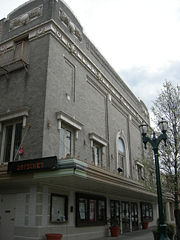
Historic Everett Theatre
Downtown Everett is home to The Comcast Arena, the Everett Performing Arts Center, home to the Village Theatre theatre company, the historic Everett Theatre, the Imagine Children's Museum, the Arts Council of Snohomish County and an array of street sculptures. The Everett Symphony (est. 1935) performs at the Everett Civic Auditorium. The city is also home to the Everett Chorale, which holds their concerts at the Everett Performing Arts Center.
Libraries[]
The historically and architecturally significant Everett Public Library is a cornerstone of Everett's downtown and a beacon to its citizens. Additionally, the Evergreen Branch, situated on busy Evergreen Way in south Everett, serves an ever-increasing, ethnically diverse neighborhood.
Professional sports teams[]
| Club | Sport | Founded | League | Venue | Championships |
|---|---|---|---|---|---|
| Everett AquaSox | Baseball | 1984 | Northwest League | Everett Memorial Stadium | 1985, 2010 |
| Everett Silvertips | Hockey | 2003 | Western Hockey League | Comcast Arena at Everett | |
| Washington Stealth | Lacrosse | 2010 | National Lacrosse League | Comcast Arena at Everett | 2010 |
| North Sound SeaWolves | Soccer | 2010 | USL Premier Development League | Goddard Memorial Stadium |
Sister cities[]
Everett has the following sister city relationships:[24]
 Iwakuni, Japan
- Sligo, Co. Sligo, Ireland
- Sovetskaya Gavan, Russia
Economy[]
Everett's early economy was tied to the lumber trade. The city's 2006 Labor workforce was more than 80,000, predominantly employed in technology, aerospace, and service-based industries.[25]
Top employers[]
According to the City's 2009 Comprehensive Annual Financial Report,[26] the top employers in the city are:
| # | Employer | # of Employees |
|---|---|---|
| 1 | Boeing | 32,000 |
| 2 | Naval Station Everett | 6,000 |
| 3 | Providence Regional Medical Center Everett | 3,200 |
| 4 | Snohomish County | 2,965 |
| 5 | State of Washington | 2,800 |
| 6 | The Everett Clinic | 1,900 |
| 7 | Everett School District | 1,700 |
| 8 | Frontier Communications Northwest | 1,500 |
| 9 | Aviation Technical Services | 1,400 |
| 10 | Zumiez | 1,400 |
Demographics[]
| Historical populations | |||
|---|---|---|---|
| Census | Pop. | %± | |
| 1900 | 7,838 | ||
| 1910 | 24,814 | 216.6% | |
| 1920 | 27,664 | 11.5% | |
| 1930 | 30,567 | 10.5% | |
| 1940 | 30,224 | −1.1% | |
| 1950 | 33,849 | 12.0% | |
| 1960 | 40,304 | 19.1% | |
| 1970 | 53,622 | 33.0% | |
| 1980 | 54,413 | 1.5% | |
| 1990 | 69,961 | 28.6% | |
| 2000 | 91,488 | 30.8% | |
| 2010 | 103,019 | 12.6% | |
| Est. 2012 | 104,655 | 14.4% | |
| Source:[27] 2012 Estimate[29] | |||
2010 census[]
As of the census[2] of 2010, there were 103,019 people, 41,312 households, and 23,282 families residing in the city. The population density was 3,079.8 inhabitants per square mile (1,189.1 /km2). There were 44,609 housing units at an average density of 1,333.6 per square mile (514.9 /km2). The racial makeup of the city was 74.6% White, 4.1% African American, 1.4% Native American, 7.8% Asian, 0.7% Pacific Islander, 6.1% from other races, and 5.3% from two or more races. Hispanic or Latino of any race were 14.2% of the population.
There were 41,312 households of which 30.5% had children under the age of 18 living with them, 38.2% were married couples living together, 12.5% had a female householder with no husband present, 5.7% had a male householder with no wife present, and 43.6% were non-families. 34.1% of all households were made up of individuals and 9.3% had someone living alone who was 65 years of age or older. The average household size was 2.39 and the average family size was 3.09.
The median age in the city was 34.4 years. 22.7% of residents were under the age of 18; 11.3% were between the ages of 18 and 24; 30.6% were from 25 to 44; 25% were from 45 to 64; and 10.3% were 65 years of age or older. The gender makeup of the city was 50.9% male and 49.1% female.
2000 census[]
As of the census of 2000, there were 91,488 people, 36,325 households and 21,613 families residing in the city. The population density is 2,814.6 people per square mile (1,086.9/km²). There are 38,512 housing units at an average density of 1,184.8 per square mile (457.5/km²). The racial makeup of the city is 56% White, 9% African American, 1.56% Native American, 10% Asian, 4% Pacific Islander, 3.13% from other races and 4.25% from two or more races. Hispanic or Latino of any race were 13% of the population.
There are 36,325 households, out of which 31.9% had children under the age of 18 living with them, 42.1% were married couples living together, 12.5% had a female householder with no husband present, and 40.5% were non-families. 31.7% of all households were made up of individuals and 8.5% had someone living alone who was 65 years of age or older. The average household size was 2.40 and the average family size was 3.04.
In the city the population was spread out with 25.1% under the age of 18, 12.3% from 18 to 24, 33.3% from 25 to 44, 18.9% from 45 to 64, and 10.3% who were 65 years of age or older. The median age was 32 years. For every 100 females there were 103.5 males. For every 100 females age 18 and over, there were 102.8 males.
The median income for a household in the city was $40,100 and the median income for a family was $46,743. Males had a median income of $35,852 versus $28,841 for females. The per capita income for the city was $20,577. About 10.1% of families and 19.5% of the population were below the poverty line, including 16% of those under the age of 18 and 12.1% of those ages 65 and older.
Crime[]
In 2012, Everett has been ranked with the 104th highest crime rate in the United States, being the highest crime rate in the Pacific Northwest outside of Tacoma, Wa. (of 393 communities ranked).[30]
In 2011, Everett had 1,183 car thefts. The city also had 76 rapes, or 78.7 rapes per 100,000 people, twice the national average rate of 32.2 rapes per 100,000 people.[31]
| Crime | Everett, Washington (2011) | National Average |
|---|---|---|
| Murder | 5 | 4.8 |
| Rape | 49 | 46.8 |
| Robbery | 143 | 136.7 |
| Assault | 253 | 241.8 |
| Burglary | 1,163 | 1,111.5 |
| Theft | 5,415 | 5,175.1 |
| Auto thefts | 925 | 884.0 |
| Arson | 27 | 25.8 |
There was only one murder in 2008, leaving the city with a murder rate well below the national average for that year.
Education[]
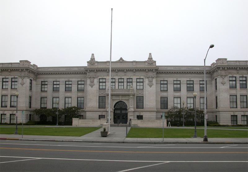
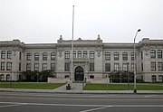
Everett High School (part of Everett Public Schools)
Higher education[]
- Everett Community College (est. 1941)
- University Center of North Puget Sound
- Western Washington University Everett Center
- ITT Technical Institute
- City University
- Ashmead College
- Bryman College
- Trinity Lutheran College
- Embry–Riddle Aeronautical University - Everett
High schools[]
Most of the city is serviced by the Everett School District (which also services areas south of the Everett, including the city of Mill Creek), however portions of southwestern Everett lie within the Mukilteo School District.
- ACES High School - 9700 Holly Drive, Everett WA 98204 (MSD: Alternative School)
- Archbishop Thomas J. Murphy High School (Private School)
- Everett High School - Located in North Everett on Colby Avenue
- Cascade High School - Located in South Everett on E. Casino Road
- Cedar Park Christian School
- Mariner High School - Located at 200 120th St. SW Everett, WA 98204 (Mukilteo School District) NOTE: Mariner High School is located outside the city limits in unincorporated Snohomish County, but has an Everett address.
- Henry M. Jackson High School - Located at 1508 136th Street SE, Mill Creek, WA 98012 NOTE: Jackson High School is an Everett Public School with a Mill Creek address.
- Montessori Schools of Snohomish County
- Sequoia High School - Located at 3516 Rucker Avenue, Everett, WA 98201
- Valley View Christian School
Middle schools[]
- Eisenhower Middle School - Located 10200 25th Ave. SE Everett
- Everett Christian School
- Evergreen Middle School - Located 7621 Beverly Ln. Everett
- Explorer Middle School
- Forest Park Adventist Christian School
- Gateway Middle School - Located 15404 Silver Firs Dr. Everett
- Heatherwood Middle School
- Immaculate Conception & Our Lady of Perpetual Help School
- Montessori Schools of Snohomish County
- North Middle School - Located 2514 Rainier Ave. Everett
- Northshore Christian Academy
- St. Mary Magdalen Catholic School
- Valley View Christian School
- Voyager Middle School
- Zion Lutheran School
Elementary schools[]
- Cedar Park Christian School
- Cedar Wood Elementary
- Discovery Elementary
- Emerson Elementary
- Everett Christian School
- Forest Park Adventist Christian School
- Forest View Elementary
- Garfield Elementary
- Hawthorne Elementary
- Immaculate Conception & Our Lady of Perpetual Help School
- Jackson Elementary
- James Monroe Elementary
- Jefferson Elementary
- Lowell Elementary
- Madison Elementary
- Mill Creek Elementary
- Montessori Schools of Snohomish County
- Northshore Christian Academy
- Olivia Park Elementary
- Penny Creek Elementary
- Silver Firs Elementary
- Silver Lake Elementary
- St. Mary Magdalen Elementary School
- Valley View Christian School
- View Ridge Elementary
- Whittier Elementary
- Woodside Elementary
- Zion Lutheran School
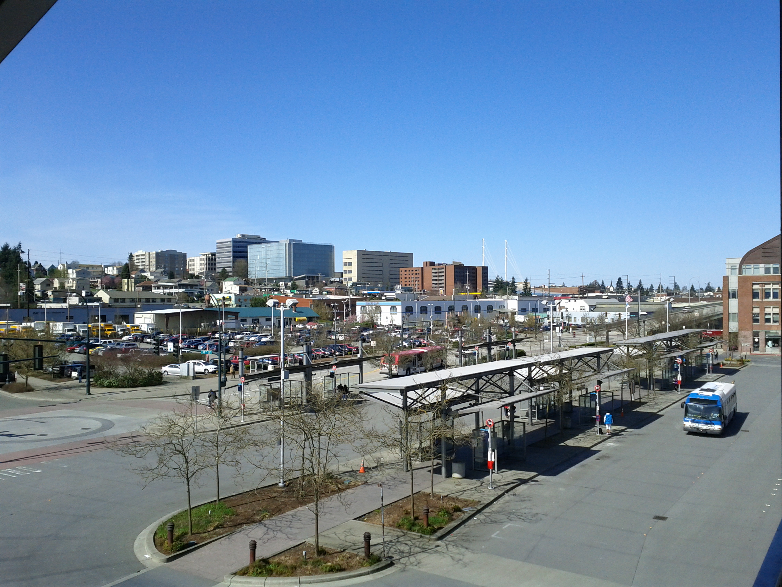
Infrastructure[]


Everett Station
Transportation[]
Everett is well-connected, consisting of an array of different transport options.
Freeway access is via Interstate 5 which passes by the city. Many highways also connect in Everett including US Highway 2 which begins in Everett.
Public transit service has operated in Everett since 1893. From 1910-1939 Everett was connected with Seattle by the Seattle-Everett Interurban Railway. Today Everett Transit (est. 1969) provides bus service within the city, operating 46 buses and 18 ParaTransit vehicles with daily ridership of 6,800.[32] Sound Transit provides commuter train and bus service to Seattle and bus service to Bellevue. Community Transit connects Everett with the remainder of Snohomish County. Amtrak provides inter-city train service via its Empire Builder and Cascades lines while Sound Transit provides commuter rail connections to Seattle via its Sounder trains. Inter-city bus service is also provided by Greyhound. All of these bus and train connections can be made at Everett Station, the hub of Everett's transportation network.
The closest international airports are Boeing Field and Seattle-Tacoma International Airport, and Snohomish County operates Paine Field (PAE) for private aviation.
Health systems[]
General Hospital was founded in 1894 by the Women's Book Club of Everett. The Sisters of Providence in the Pacific Northwest established Providence Hospital in 1905. Both hospitals merged on March 1, 1994 to form what is now called Providence Regional Medical Center Everett.[33] In 2005 it was named one of America's 100 top hospitals for the third time in thirteen years.[34]
Providence Regional Medical Center Everett statistics for 2009:[35]
- Licensed Beds: 372
- Deliveries: 3,900
- Emergency Department Visits: 111,000
- Inpatient Admissions: 26,000
- Surgeries: 13,000
- Providence Physician Group Visits: 276,000
- Employees: 3,200
- Medical Staff: 884
- Providence Physician Group Providers: 110
- Volunteers: 950
The Everett Clinic was established in 1924 by four Everett physicians and has evolved into a regional health-care provider with sixteen locations throughout Snohomish County. It serves more than 2,300 patients each day.[36]
Utilities[]
The city of Everett's water originates in the Spada reservoir in the Sultan Basin Watershed of the Cascade Mountains. The city's water system provides drinking water not only to the city but roughly half a million people in Snohomish County. It is treated at the Everett Water Filtration Plant near Sultan. Electricity is provided by Snohomish County PUD. Natural gas is provided by Puget Sound Energy.
Notable natives and residents[]
- Arts
- Donna Barr, comic book author
- Nancy Coleman, actress
- Patrick Duffy, actor
- David Eddings, fantasy author
- Daniel E. Freeman, musicologist
- Carol Kaye, bass player
- Kenny Loggins, singer/songwriter
- Peg Phillips, actress
- Mark P. Shea, Catholic author
- Cherie Witter, model and actress
- Mark L. Young, actor
- Criminal
- Ryan G. Anderson, convicted al-Qaeda enabler
- Military
- James E. Kyes, Navy Cross recipient Commander (O-5)
- Political and business
- Glenn Beck, American conservative author and radio/TV host
- Jean Berkey, Washington state legislator
- David Marston Clough, former Minnesota governor and politician
- Henry M. Jackson, Congressman and Senator
- J. H. Smith, politician and pioneer
- Elmer R. Tapper, former member of the Louisiana House of Representatives, retired to Everett. He died in 2011.
- Larry Vognild, politician
- Sports
- Rick Anderson, MLB pitching coach
- Chris Chandler, NFL Quarterback
- Larry Christenson, former Philadelphia Phillies Pitcher
- Randy Couture, Mixed Martial Artist[37]
- Tom Cable, football coach
- Dennis Erickson, football coach
- Jim Lambright, football coach
- Brent Lillibridge, MLB infielder
- Chuck Nelson, NFL kicker
- Mike Price, football coach
- Grady Sizemore, MLB outfielder
- Travis Snider, MLB outfielder
- Earl Torgeson, MLB first baseman
- T.J. Oshie, NHL forward for the St. Louis Blues
Gallery[]
")
")
")
")
")
")
")
")
")
")
")
")
")
")
")
")
")
")
See also[]
- Boeing Everett Factory
- Comcast Arena (Everett) (formerly known as the Everett Events Center)
- Everett Mall
- Future of Flight Aviation Center & Boeing Tour
- National Register of Historic Places listings in Snohomish County, Washington
References[]
- ^ a b "US Gazetteer files 2010". United States Census Bureau. http://www.census.gov/geo/www/gazetteer/files/Gaz_places_national.txt. Retrieved 2012-12-19.
- ^ a b "American FactFinder". United States Census Bureau. http://factfinder2.census.gov/faces/nav/jsf/pages/index.xhtml. Retrieved 2012-12-19.
- ^ "Population Estimates". United States Census Bureau. http://www.census.gov/popest/data/cities/totals/2012/SUB-EST2012.html. Retrieved 2013-06-01.
- ^ "ZIP code lookup". United States Postal Service. http://zip4.usps.com/zip4/citytown.jsp. Retrieved 2008-12-23.
- ^ "US Board on Geographic Names". United States Geological Survey. 2007-10-25. http://geonames.usgs.gov. Retrieved 2008-01-31.
- ^ "Find a County". National Association of Counties. http://www.naco.org/Counties/Pages/FindACounty.aspx. Retrieved 2011-06-07.
- ^ "Building Up Everett: A Brief History by the Decade". historiceverett.org. http://www.historiceverett.org/history.html. Retrieved Mar 6, 2012.
- ^ "Washington State Office of Financial Management Official April 1, 2010 Population Census" (.xls). Washington State Office of Financial Management. 2009-06-29. http://www.census.gov/newsroom/releases/archives/2010_census/cb11-cn45.html. Retrieved 2009-06-29.
- ^ "Past Winners of the All-America City Award". National Civic League. http://www.ncl.org/aac/past_winners/past_winners.html. Retrieved 2009-05-25.
- ^ "About the Port of Everett". Port of Everett. http://www.portofeverett.com/home/index.asp?page=2. Retrieved February 12, 2009.
- ^ Tuinstra, Rachel (September 24, 2003). "A $71.5 million Venue Represents a Big Leap of Faith' for the City". The Seattle Times. http://community.seattletimes.nwsource.com/archive/?date=20030924&slug=center24n. Retrieved March 25, 2012.
- ^ Governors Office of Indian Affairs
- ^ "US Gazetteer files: 2010, 2000, and 1990". United States Census Bureau. 2011-02-12. http://www.census.gov/geo/www/gazetteer/gazette.html. Retrieved 2011-04-23.
- ^ Port of Everett - Marina
- ^ Port of Everett - Cargo Statistics
- ^ http://www.everettyachtclub.com/New_History_Page.html
- ^ Sunday Afternoon Waterfront Series in Everett
- ^ everettcohoderby.com
- ^ FRESH PAINT | .Graffiti Art .Murals .Workshops .Scotland
- ^ Everett Parks in Everett
- ^ Nishiyama Japanese Garden
- ^ Evergreen Arboretum and Gardens
- ^ Neighborhood associations in Everett
- ^ Sister Cities, States, Counties & Ports
- ^ http://everettwa.usachamber.com/custom2.asp?pageid=2570
- ^ City of Everett CAFR
- ^ Moffatt, Riley. Population History of Western U.S. Cities & Towns, 1850-1990. Lanham: Scarecrow, 1996, 320.
- ^ "U.S. Decennial Census". Census.gov. http://www.census.gov/prod/www/decennial.html. Retrieved June 6, 2013.
- ^ "Annual Estimates of the Resident Population: April 1, 2010 to July 1, 2012". http://www.census.gov/popest/data/cities/totals/2012/SUB-EST2012-3.html. Retrieved June 6, 2013.
- ^ "2012 City Crime Rate Rankings*". CQ Press. http://os.cqpress.com/citycrime/2012/CityCrime2013_CityCrimeRateRankings.pdf.
- ^ "Crime rate in Everett, Washington (WA): murders, rapes, robberies, assaults, burglaries, thefts, auto thefts, arson, law enforcement employees, police officers, crime map". City-data.com. 2013-06-06. http://www.city-data.com/crime/crime-Everett-Washington.html. Retrieved 2013-06-06.
- ^ http://www.soundtransit.org/x5907.xml
- ^ Providence Washington | Providence Washington
- ^ http://www.providence.org/everett/news/solucient.htm
- ^ Providence Washington | Providence Washington
- ^ The Everett Clinic: Physicians, Surgeons, Specialists Everett Snohomish
- ^ Randy Couture at the Internet Movie Database
Archives[]
- Preliminary Guide to the Everett Education Association Records. 1937-2002. 28.06 cubic feet. At the Labor Archives of Washington, University of Washington Libraries Special Collections.
External links[]
- City of Everett Official Website
- Everett Public Library Website
- Port of Everett
- Everett, Washington at the Open Directory Project
| ||||||||||||||||||||||||||

-1.jpg)
| |||||||||||||||||||||||||||||||||||||||||
| ||||||||||||||
Template:Washington cities and mayors of 100,000 population
| This page uses content from the English language Wikipedia. The original content was at Everett, Washington. The list of authors can be seen in the page history. As with this Familypedia wiki, the content of Wikipedia is available under the Creative Commons License. |