| Main | Births etc |
|---|
| Erfurt | |
|---|---|
| View over Erfurt | |
| Country | Germany |
| State | Thuringia |
| Admin. region | |
| District | Urban district |
| Founded | |
| First mentioned | 742 |
| Subdivisions | 53 districts |
| Government | |
| • Lord Mayor | Andreas Bausewein (SPD) |
| • Governing parties | SPD / The Left / Greens |
| Area | |
| • Total | 269.17 km2 (103.93 sq mi) |
| Elevation | 200 m (700 ft) |
| Population (2010-12-31)[1] | |
| • Total | 204,994 |
| • Density | 760/km2 (2,000/sq mi) |
| Time zone | CET/CEST (UTC+1/+2) |
| Postal codes | 99001-99198 |
| Dialling codes | 0361 |
| Vehicle registration | EF |
| Website | www.erfurt.de/ef/en (English) |
Erfurt (German pronunciation: [ˈɛʁfʊʁt][2]) is the capital city of Thuringia and the main city nearest to the geographical centre of modern Germany, located 100 kilometres (62 miles) south-west of Leipzig, 150 km (93 miles) north of Nuremberg and 180 km (112 miles) south east of Hanover. Together with neighboring cities Weimar and Jena it forms the central metropolitan area of Thuringia with approximately 500,000 inhabitants. Notable institutions in Erfurt are the Federal Labour Court of Germany, the University of Erfurt and the Fachhochschule Erfurt as well as the Roman Catholic Diocese of Erfurt with Erfurt Cathedral as one of the main sights. Further famous buildings are the Krämerbrücke, a bridge completely covered with dwellings, and Erfurt Synagogue which was established in the 11th century and is the oldest standing synagogue in Europe. Furthermore, the medieval city centre consists of old timber-framed houses and about 25 Gothic churches.
Erfurt was first mentioned in 742, as Saint Boniface founded the diocese. Although the town did not belong to one of the Thuringian states politically, it quickly became the economic centre of the region. Until the Napoleonic era it was part of the Electorate of Mainz and afterwards it belonged to Prussia until 1945. The university was founded in 1392, closed in 1816 and reestablished after German reunification in 1994. It is one of the oldest universities in Germany. Martin Luther was the most famous student of the institution. Other famous Erfurtians are the medieval theologian Meister Eckhart, the Baroque composer Johann Pachelbel, the sociologist Max Weber and Gunda Niemann-Stirnemann, the most successful speed skater of all time.
The city's economy is based on agriculture, horticulture and microelectronics. Its central location has led to it becoming a logistics hub for Germany and central Europe. Erfurt hosts the second-largest trade fair in eastern Germany (after Leipzig) as well as public television's children’s channel KiKa.
Erfurt lies in the southern part of the Thuringian Basin, within the wide valley of the Gera river.
History[]
Prehistoric Times[]
Erfurt is an old Germanic settlement. The earliest evidence of human settlement dates from the prehistoric era; archaeological finds from the north of Erfurt revealed human traces from the paleolithic period, ca. 100,000 BCE. The Melchendorf dig in the southern city part showed a settlement from the neolithic period. The Thuringii inhabited the Erfurt area ca. 480 and gave their name to Thuringia ca. 500.
Middle Ages[]
Erfurt, woodcut from the Nuremberg Chronicle, 1493
Old synagogue (the oldest in Europe, 1094)
Collegium maius building of old university (1392)
The town is first mentioned in 742 under the name of "Erphesfurt": in that year, Saint Boniface writes Pope Zachary to tell him that he had established three dioceses in central Germany, one of which "in a place called Erphesfurt, which for a long time has been inhabited by pagan natives." All three dioceses (the other two were Würzburg and Büraburg) were confirmed by Zachary the next year, though 755 Erfurt was brought into the diocese of Mainz.[3] That the place was populous already is borne out by archeological evidence, which includes 23 graves and six horse burials from the sixth and seventh centuries.[4]
Throughout the Middle Ages, it was an important trading town because of its location, near a ford across the Gera river. Together with the other five Thuringian woad towns of Gotha, Tennstedt, Arnstadt and Langensalza it was the centre of the German woad trade, which made those cities very wealthy. Erfurt was the junction of important trade routes: the Via Regia was one of the most used streets in east-west direction between France and Russia (via Frankfurt, Erfurt, Leipzig and Wrocław) and another route in north-south direction was the connection between the Baltic Sea ports (e. g. Lübeck) and the potent upper Italian city-states like Venice and Milan.
During the 10th and 11th century both the Empire and the Electorate of Mainz held some privileges in Erfurt. The German kings had an important monastery on Petersberg hill and the bishops of Mainz charged taxes from the people. Around 1100, some people became free citizens by paying the annual "Freizins" (liberation tax), which marks a first step in developing an independent city. During the 12th century, as a sign of more and more independence, the citizens built a city wall around Erfurt in today's Juri Gagarin circular road area. After 1200, the independence was fulfilled and a city council was founded in 1217; the town hall was built in 1275. In the following decades, the council bought a city-owned territory around Erfurt which consisted at its height of nearly 100 villages and castles and even another small town (Sömmerda). Erfurt became an important regional power between the Landgraviate of Thuringia around, the Electorate of Mainz to the west and the Electorate of Saxony to the east. Between 1306 and 1481, Erfurt was allied with the two other major Thuringian cities (Mühlhausen and Nordhausen) in the Thuringian City Alliance and the three cities joined the Hanseatic League together in 1430. A peak in economic development was reached in 15th century, when the city had a population of 20,000 making it to one of the biggest in Germany. Between 1432 and 1446, a second and bigger city wall was established. In 1483, a first city fortress was built on Cyriaksburg hill in the southwestern part.
The Jewish community of Erfurt was founded in 11th century and became, together with Mainz, Worms and Speyer, one of the most influential in Germany. Their synagoge is still extant and a museum today, same as the mikveh at Gera river near Krämerbrücke. In 1349, during the wave of Black Death Jewish persecutions across Europe, the Jews of Erfurt were rounded up, with more than 100 killed and the rest driven from the city. Before the persecution, a wealthy Jewish merchant buried his property in the basement of his house. In 1998, this treasure was found during construction works. The Erfurt Treasure with various gold and silver objects is shown in the exhibition in the synagogue today. Only a few years after 1349, the Jews moved back to Erfurt and founded a second community, which was disbanded by the city council in 1458.
In 1392, the University of Erfurt was founded. Together with the University of Cologne it was one of the first city-owned universities in Germany, while they were usually owned by the Territorial lords. Some buildings of this old university are extant or restored in the "Latin quarter" in the northern city centre (like Collegium maius, student dorms "Georgenburse" and others, the hospital and the church of the university). The university became quickly a hotspot of German cultural life in Renaissance humanism with scholars like Ulrich von Hutten, Helius Eobanus Hessus and Justus Jonas.
Early modern period[]
Erfurt in 1650


Palace of the Mainz Governors (at front)
In 1501 Martin Luther moved to the university as a student. After 1505, he lived in the Augustine Monastery and 1507 he became priest in Erfurt Cathedral. He moved to Wittenberg in 1511. His Protestant Reformation found its way to Erfurt in 1521. In 1530, the city became one of the first in Europe to be officially bi-confessional with the Hammelburg Treaty. It kept that status through all the following centuries. The later 16th and the 17th century brought a slow economic decline of Erfurt. The trade shrunk, the number of population was falling and the university lost its influence. The city's independence was endangered. In 1664, the city and surrounding area were brought under the dominion of the Electorate of Mainz and the city lost its independence. The Electorate built a huge fortress on Petersberg hill between 1665 and 1726 to control the city and instituted a governor to rule Erfurt.
During the late 18th century, Erfurt saw another cultural peak. Governor Karl Theodor Anton Maria von Dalberg held deep relations to Johann Wolfgang von Goethe, Friedrich Schiller, Johann Gottfried Herder, Christoph Martin Wieland and Wilhelm von Humboldt, who often visited him at his court in Erfurt.
Erfurt became part of the Kingdom of Prussia in 1802. In the Capitulation of Erfurt the city, its 12,000 defenders, and the Petersberg fortress were handed over to the French on 16 October 1806. The city became part of the First French Empire in 1806 as Principality of Erfurt, and was returned to Prussia in 1815 after the Napoleonic Wars. Although enclosed by Thuringian territory in the west, south and east, the city remained part of the Prussian Province of Saxony until 1944. In 1808, the Congress of Erfurt was held with Napoleon and Alexander I of Russia visiting the city.
Since 1815[]


Streetscape in the southern city extension (Gründerzeit style)


Housing projects in Bauhaus style from 1930
Hotel "Erfurter Hof", place of the first German-German chancellor meeting in 1970
After the 1848 Revolution, many Germans desired to have a united national state. An ettempt on this way was the site of the failed Erfurt Union of German states in 1850.
The Industrial Revolution reached Erfurt in the 1840s, when the Thuringian Railway as connection between Berlin and Frankfurt was built. During the following years, many factories in different sectors were founded. One of the biggest was the Royal Gun Factory of Prussia in 1862. After German Unification in 1871, Erfurt moved from the southern border of Prussia to the centre of Germany, so that the fortifications of the city weren't necessary anymore. The defortification in 1873 led to a construction boom in Erfurt, because it was allowed to build in front of the former city walls now. Many public and private buildings emerged and the infrastructure (e. g. tramway, hospitals, schools) improved rapidly. The number of inhabitants grew from 40,000 around 1870 to 130,000 in 1914 and the city extended in all directions.
The Erfurt Program was adopted by the Social Democratic Party of Germany during its congress at Erfurt in 1891.
Between the wars, the city kept growing. Housing shortage was fought with building programmes and social infrastructure was broadened according to the welfare policy in Weimar Republic. The Great Depression between 1929 and 1932 led to a disaster for Erfurt, nearly one out of three became unemployed. Conflicts between far-left and far-right oriented milieus tightened and many inhabitants appreciated with the new nazi government and Hitler. Others, specially some communist workers, rendered resistance against the new administration. In 1938, the new synagogue at today's Juri Gagarin circular road was destroyed during the Kristallnacht. Jews lost their property and emigrated or got deported to the Nazi concentration camps (together with many communists). In 1914 the company Topf and Sons began the manufacture of crematoria later becoming the market leader in this industry. Under the Nazis, JA Topf & Sons supplied specially developed crematoria, ovens and associated plant to the death camps at Auschwitz-Birkenau and Mauthausen. On 27 January 2011 a memorial and museum dedicated to the Holocaust victims killed using Topf ovens was opened at the former company premises in Erfurt.
Bombed as a target of the Oil Campaign of World War II, Erfurt suffered only limited damage and was captured on 12 April 1945, by the US 80th Infantry Division.[5] On 3 July, American troops left the city, which then became part of the Soviet Zone of Occupation and German Democratic Republic. In 1948, Erfurt became the capital of Thuringia, replacing Weimar. In 1952, the Länder in GDR were liquidated in favour of forced centralization under the socialist regime. Erfurt then became the capital of a new "Bezirk". In 1953, the Hochschule of education was founded, followed by the Hochschule of medicine in 1954, the first academical institutions in Erfurt since the closing of the university in 1816.
On 19 March 1970 the East and West German Chancellors Willi Stoph and Willy Brandt met in Erfurt, the first such meeting since the division of Germany. During the 1970s and 1980s, as the economic situation in GDR worsened, many old buildings in city centre decayed, while the government fought against housing shortage by building large Plattenbau settlements in the periphery. The Peaceful Revolution 1989/1990 led to German reunification.
With the re-formation of Thuringia in 1990, the city became the capital once again. After the reunification, a deep economic crisis occurred in Eastern Germany. Many factories closed and many people lost their jobs and moved to the area formerly known as West Germany. On the other hand, many buildings got redeveloped and the infrastructure improved massively. In 1994, the new university was opened, same as the Fachhochschule in 1991. After 2005, the economic situation improved as the unemployment rate decreased and new enterprises developed. Also the population began to increase once again.
In 2002, a student ran amok at a local Gymnasium. The Erfurt massacre with 17 deaths was the first large school massacre in Germany.
Geography and demographics[]
Gera river in city centre
Topography[]
Erfurt is situated in the south of the Thuringian basin, a fertile agricultural area between the Harz mountains 80 km (50 mi) in the north and the Thuringian forest 30 km (19 mi) in the southwest. Whereas the northern parts of the city area are flat, the southern ones consist of hilly landscape up to 430 m of elevation. In this part lies also the municipal forest of Steigerwald with beeches and oaks as main tree species. To the east and to the west are some non-forested hills so that the Gera river valley within the town forms a basin. North of the city are some gravel pits in operation, while others are abandoned, flooded and used as leisure area for Erfurters.
Climate[]
Erfurt has a humid continental climate (Dfb) or an oceanic climate (Cfb) according to the Köppen climate classification system.[6][7] Summers are warm and sometimes humid with average high temperatures of 23 °C (73 °F) and lows of 12 °C (54 °F). Winters are relatively cold with average high temperatures of 2 °C (36 °F) and lows of −3 °C (26.6 °F). The city's topography creates a microclimate caused through the basin position with sometimes inversion in winter (quite cold nights under −20 °C (−4.0 °F)) and inadequate air circulation in summer. Annual precipitation is only 502 millimeters (19.8 in) with moderate rainfall throughout the year. Light snowfall mainly occurs from December through February, but snow cover does not usually remain for long.
| Climate data for Erfurt (1971-2000) | |||||||||||||
|---|---|---|---|---|---|---|---|---|---|---|---|---|---|
| Month | Jan | Feb | Mar | Apr | May | Jun | Jul | Aug | Sep | Oct | Nov | Dec | Year |
| Average high °C (°F) | 2.2 (36.0) |
3.2 (37.8) |
7.8 (46.0) |
12.2 (54.0) |
17.5 (63.5) |
20.1 (68.2) |
22.5 (72.5) |
22.7 (72.9) |
18.3 (64.9) |
12.7 (54.9) |
6.4 (43.5) |
3.4 (38.1) |
12.4 (54.3) |
| Average low °C (°F) | −3.1 (26.4) |
−2.9 (26.8) |
0.3 (32.5) |
2.8 (37.0) |
7.1 (44.8) |
10.2 (50.4) |
12.1 (53.8) |
12.0 (53.6) |
9.1 (48.4) |
5.1 (41.2) |
0.9 (33.6) |
−1.5 (29.3) |
4.3 (39.7) |
| Precipitation mm (inches) | 24.7 (0.972) |
23.8 (0.937) |
35.5 (1.398) |
40.3 (1.587) |
54.8 (2.157) |
60.8 (2.394) |
62.5 (2.461) |
52.8 (2.079) |
40.5 (1.594) |
36.8 (1.449) |
37.5 (1.476) |
31.5 (1.24) |
501.5 (19.744) |
| Avg. precipitation days (≥ 1.0 mm) | 7.0 | 6.7 | 8.3 | 7.9 | 8.5 | 10.0 | 8.7 | 8.3 | 7.4 | 6.9 | 7.8 | 7.6 | 95.1 |
| Source: World Meteorological Organization[8] | |||||||||||||
Administrative division[]
Districts of Erfurt
Erfurt abuts the districts of Sömmerda (municipalities Witterda, Elxleben, Walschleben, Riethnordhausen, Nöda, Alperstedt, Großrudestedt, Udestedt, Kleinmölsen and Großmölsen) in the north, Weimarer Land (municipalities Niederzimmern, Nohra, Mönchenholzhausen and Klettbach) in the east, Ilm-Kreis (municipalities Kirchheim, Rockhausen and Amt Wachsenburg) in the south and Gotha (municipalities Nesse-Apfelstädt, Nottleben, Zimmernsupra and Bienstädt) in the west.
The city itself is divided in 53 districts. The centre is formed by the district Altstadt (old town) and the Gründerzeit districts Andreasvorstadt in the northwest, Johannesvorstadt in the northeast, Krämpfervorstadt in the east, Daberstedt in the southeast, Löbervorstadt in the southwest and Brühlervorstadt in the west. More former industrial districts are Ilversgehofen (incorporated in 1911), Hohenwinden and Sulzer Siedlung in the north. Another group of districts is marked by Plattenbau settlements, constructed during the GDR period: Berliner Platz, Moskauer Platz, Rieth, Roter Berg and Johannesplatz in the northern as well as Melchendorf, Wiesenhügel and Herrenberg in the southern city parts.
Finally, there are many villages with an average population of approximately 1,000 which got incorporated during the 20th century; however, they mostly stayed rural to date:
|
|
|
Demographics[]
Evolution of population until 2003
| Ten largest groups of foreign residents[9] | |
| Country of Origin | Population (2011) |
|---|---|
| 710 | |
| 661 | |
| 594 | |
| 432 | |
| 293 | |
| 233 | |
| 207 | |
| 207 | |
| 179 | |
| 169 | |
Around the year 1500, the city had 18,000 inhabitants and was one of the biggest cities in the Holy Roman Empire. Population stagnated then until the 19th century. The population of Erfurt was 21,000 in 1820, and increased to 32,000 in 1847, the year of rail connection as industrialization began. In the following decades Erfurt grew up to 130,000 at the beginning of World War I and 190,000 inhabitants in 1950. A maximum was reached in 1988 with 220,000 persons. The bad economic situation in eastern Germany after the reunification resulted in a decline in population, which fell to 200,000 in 2002 before rising again to 206,000 in 2011. The average growth of population between 2009 and 2012 was approximately 0.68% p. a, whereas the population in bordering rural regions is shrinking with accelerating tendency. Suburbanization played only a small role in Erfurt. It occurred after the reunification for a short time in the 1990s, but most of the suburban areas were situated within the administrative city borders.
The birth deficit was 200 in 2012, this is -1.0 per 1,000 inhabitants (Thuringian average: -4.5; national average: -2.4). The net migration rate was +8.3 per 1,000 inhabitants in 2012 (Thuringian average: -0.8; national average: +4.6).[10] The most important regions of origin of Erfurt migrants are rural areas of Thuringia, Saxony-Anhalt and Saxony as well as foreign countries like Poland, Russia, Ukraine, Hungary, Serbia, Romania and Bulgaria.
Like other eastern German cities, Erfurt has only a small amount of foreign population: circa 3.0% are non-Germans by citizenship and overall 5.9% are migrants (according to 2011 EU census). Differing from the national average, the biggest groups of migrants in Erfurt are Vietnamese people, Russians and Ukrainians. During recent years, the economic situation of the city improved: the unemployment rate declined from 21% in 2005 to 9% in 2013. Nevertheless, some 14,000 households with 24,500 persons (12% of population) are dependent upon state social benefits (Hartz IV). Due to the official atheism in former GDR, most of the population is non-religious. 14.8% are members of the Evangelical Church in Central Germany and 6.8% are Catholics (according to 2011 EU census). The Jewish Community consists of 500 members. Most of them migrated to Erfurt from Russia and Ukraine in the 1990s.
Culture, sights and cityscape[]
Notable residents in cultural history[]
Martin Luther attended the University of Erfurt and received his bachelor's and master's degrees of theology there. Luther lived there as a student from 1501 to 1511 and, as a monk, from 1505 to 1511.
The city is the birthplace of one of Johann Sebastian Bach's cousins, Johann Bernhard Bach, as well as Johann Sebastian Bach's father Johann Ambrosius Bach. Bach's parents were married in 1668 in a small church, the Kaufmannskirche (Merchant's Church), that still exists on the main square, Anger.
The sociologist Max Weber was born in Erfurt,[11] and the theologian and philosopher Meister Eckhart was Prior of Erfurt's Dominican Order.
Johann Pachelbel served as organist at the Prediger church in Erfurt. Pachelbel composed approximately seventy pieces for organ while in Erfurt. After 1906 the composer Richard Wetz lived in Erfurt and became the leading person in the town's musical life. His major works were written here, including three symphonies, a Requiem and a Christmas Oratorio.
Famous modern musicians from Erfurt are Clueso, the Boogie Pimps, Northern Lite or Yvonne Catterfeld.
Museums[]
Erfurt has a great variety of museums:
- The Stadtmuseum (municipal museum) shows some aspects of Erfurt's history with a focus on Middle Ages, early modern history, Martin Luther and the university. Other parts of the Stadtmuseum are the Neue Mühle (new mill), an old water mill still in function and the Benaryspeicher (Benary's magazine) with an exhibition of old printing machines.
- The Angermuseum is the art museum of Erfurt, named after the Anger square, where it is located. It focusses on modern graphic arts, medieval sculpting and early modern artisanal handicraft.
- The Naturkundemuseum (natural history museum) is situated in an medieval woad magazine and exhibits objects of Thuringian flora and fauna, geology and ecology.
- The Deutsches Gartenbaumuseum (national museum of horticulture) is accommodated in 17th century citadel Cyriaksburg and shows the history of German horticulture, in what Erfurt always has been a centre.
- The Museum für Thüringer Volkskunde (museum of popular art and cultural anthropology) attends to the common life of people in Thuringia in the past and shows exhibits of peasant and artisan traditions.
- The Alte Synagoge (Erfurt Synagogue) was opened in 2009 and shows the Erfurt Treasure together with some medieval Hebrew manuscripts.
- The Elektromuseum (museum of electrical engineering) shows the history of electric engines, which is an important field of Erfurt's economy.
- The Erinnerungsort Topf & Söhne (memorial site of Topf and Sons) shows an exhibition about the company Topf and Sons, which constructed the crematories of Auschwitz and other concentration camps.
- The Kunsthalle Erfurt (Erfurt art gallery) shows varying exhibitions of contemporary art.
- The Peterskirche (Saint Peter's church) houses an exhibition of Concrete art.
- The Schloss Molsdorf in the district of Molsdorf is a baroque palace with an exhibition about the painter Otto Knöpfer.
")
")
")
")
")
")
")
Theatre[]
Since 2003, the modern opera house is home to Theater Erfurt and its Philharmonic Orchestra. The "grand stage" section has 800 seats and the "studio stage" can hold 200 spectators. In September 2005, the opera Waiting for the Barbarians by Philip Glass premiered in the opera house. The Erfurt Theater has been a source of controversy recently. In 2005 a performance of Engelbert Humperdinck's opera Hänsel und Gretel stirred up the local press since the performance contained suggestions of pedophilia and incest. The opera was advertised in the program with the addition "for adults only".
On 12 April 2008, a version of Verdi's opera Un ballo in maschera directed by Johann Kresnik opened at the Erfurt Theater. The production stirred deep controversy by featuring nude performers in Mickey Mouse masks dancing on the ruins of the World Trade Center and a female singer with a painted on Hitler toothbrush moustache performing a straight arm Nazi salute, along with sinister portrayals of American soldiers, Uncle Sam, and Elvis Presley impersonators. The director described the production as a populist critique of modern American society, aimed at showing up the disparities between rich and poor. The controversy prompted one local politician to call for locals to boycott the performances, but this was largely ignored and the premiere was sold out.[12]
Sport[]
Gunda Niemann-Stirnemann Halle
Notable types of sport in Erfurt are athletics, ice skating, cycling (with the oldest velodrome in use in the world, opened in 1885), swimming, handball, volleyball, tennis and football. The city's football club FC Rot-Weiß Erfurt is member of 3. Fußball-Liga and based in Steigerwaldstadion with a capacity of 20,000. The Gunda Niemann-Stirnemann Halle was the second indoor speed skating arena in Germany.
Cityscape[]


Architecture of Gründerzeit in Brühlervorstadt district
Erfurt's cityscape is near to the ideal of a European city: In the middle a medieval core of narrow, curved alleys, surrounded by a belt of Gründerzeit architecture, created between 1873 and 1914. In 1873 the city was defortificated so that it was now allowed to build houses in the area in front of the former city walls. In the following years, Erfurt saw a construction boom. In the northern area (districts Andreasvorstadt, Johannesvorstadt and Ilversgehofen) emerged some tenements for the factory workers, in the eastern area (Krämpfervorstadt and Daberstedt) some apartments for white-collar workers and clerks and in the southwestern part (Löbervorstadt and Brühlervorstadt) with its beautiful valley landscape some villas and mansions of rich factory owners and notables. During the interwar period, some settlements in Bauhaus style were realized, often as housing cooperatives. After World War II and over the whole GDR period, housing shortage remained a problem even though the government started a big flat construction programme. Between 1970 and 1990 emerged large Plattenbau settlements with high-rise blocks on the northern (for 50,000 inhabitants) and southeastern (for 40,000 inhabitants) periphery. After the reunification the renovation of old houses in city centre and the Gründerzeit areas was a big issue. The federal government granted high subsidies, so that many houses could be restored.
In World War II, little of Erfurt was destroyed as compared to many other cities in Germany. This is one reason why the centre today offers a mixture of medieval, baroque and classical architecture added by buildings from the last 150 years. Public green spaces are located along Gera river and in several parks like the Stadtpark, the Nordpark and the Südpark. The biggest green area is the egapark, a horticultural exhibition park and botanic garden established in 1961, but it is not accessible without an entry fee and some activities like barbecue or ball games are restricted.
Sights and architectural heritage[]
Churches, monasteries and synagogues[]


St Mary's Cathedral (left) and St Severus' Church (right) on Domberg hill
The city centre hosts about 25 churches and monasteries, most of them in gothic style, some also in Romanesque style or a mixture of romanesque and gothic elements, and few in later styles. The various steeples characterize the medieval centre and led to one of Erfurt's nicknames as the "Thuringian Rome".
Catholic churches and monasteries:
- The Allerheiligenkirche (All Saints Church) is a 14th-century gothic parish church at Market Street, which hosts a Columbarium.
- The Dom St. Marien (St Mary's Cathedral) is the biggest church in Erfurt on Domberg hill near the Dom Square. It combines romanesque and gothic elements and hosts one of the biggest medieval bells, the Gloriosa. Furthermore it is the bishops see and one of the main sights of Erfurt.
- The Lorenzkirche (St Laurence's Church) is a small 14th century gothic parish church at Anger Square.
- The Martinikirche (St Martin's Church) was built in 15th century in gothic style and later baroque converted. It was both a Cistercian monastery and a parish church of Brühl, a medieval suburban zone.
- The Neuwerkskirche St. Crucis (New plant church/Holy Cross Church) is a 15th-century gothic parish church at Neuwerk Street, that got baroque converted later. Until 1285, it was used as an Augustinian monastery.
- The Schottenkirche St. Nikolai und St. Jakobi (Scots monks Church St Nicholas and St James) is an 11th-century romanesque monastery church with a baroque façade, which was later used as a parish church.
- The Severikirche (St Severus' Church) is the second-largest parish church after the cathedral and stands next to it on the Domberg hill. It is a gothic church and was built around 1300.
- The Ursulinenkirche (Ursulines Church) is a gothic monastery church at Anger Square. It hosts the only still used monastery in Erfurt.
- The Wigbertikirche (St Wigbert's Church) is a 15th-century gothic parish church at Anger Square.
")
")
")
")
")
_110.jpg "Landtagprojekt Thueringen Erfurt 2011 (RaBoe) 110.jpg (761 KB)")
")
Evangelical churches and monasteries:
- The Ägidienkirche (St Giles' Church) is a 14th-century gothic parish church at Wenigenmarkt Square. It is the preserved one of former two bridge-head churches of Krämerbrücke on both ends of the bridge. Due to that, the hall is on the 1st floor, while on ground level is a passage to the bridge. The steeple is open (with entrance fee) and offers a good view over the city centre. Today, St Giles' Church is a Methodist parish church.
- The Andreaskirche (St Andrew's Church) is a 14th-century gothic parish church at Andrew's Street. The old craftsmen quarter around is named Andreasviertel after the church.
- The Augustinerkirche (St Augustine's Church) is a 14th-century gothic monastery church at Augustine's Street. Martin Luther lived here as a monk between 1505 and 1512. Today, the church and the monastery are owend by the Evangelical church, which uses them as a conference and education centre.
- The Kaufmannskirche St. Gregor (Merchant's Church St Gregory) is a 14th-century gothic parish church at Anger Square. It is one of the biggest and most important original parish churches in Erfurt. The parents of Johann Sebastian Bach, Johann Ambrosius Bach and Maria Elisabeth Lämmerhirt married here in 1668.
- The Michaeliskirche (St Michael's Church) is a 13th-century gothic parish church at Michael's Street. It became the church of the university in 1392.
- The Predigerkirche (Preacher's Church) is a 14th-century gothic monastery church of the Dominicans at Preacher's Street. Since the Reformation in 16th century, it is the evangelical main church of Erfurt and furthermore one of the biggest former mendicant orders churches in Germany.
- The Reglerkirche St. Augustinus (Regulated St Augustine's Church) is a 12th-century romanesque-gothic monastery church of the Augustinians at Station Street. After the Reformation, it became an evangelical parish church.
")
")
")
")
")
.JPG "Erfurt Predigerkirche (2).JPG (392 KB)")
")
Former churches:
- The Barfüßerkirche (Discalced's Church) is a 14th-century gothic monastery church at Discalced's Street. The former Franciscanian monastery became an evangelical parish church after the Reformation. In 1944, the church was destroyed by bombings. Since that time, it is a ruin and memorial against war and violence.
- The Bartholomäuskirche (St Bartholomew's Church) was a parish church at Anger Square. The church was demolished until 1667 and only the steeple remained. Today, the steeple hosts a carillon with 60 bells.
- The Georgskirche (St George's Church) was a parish church at Michael's Street. It was demolished in 1632 for gaining construction material for the new citadel, only the steeple remained.
- The Hospitalkirche (Hospital Church) was the church of the former Great City Hospital at Juri Gagarin circular road. It is a 14th-century gothic building and now part of the museum of popular art and cultural anthropology.
- The Johanneskirche (St John's Church) was a parish church at John's Street. It was demolished in 1819, but the steeple remained.
- The Kartäuserkirche St. Salvatorberg (Cartusians Church Mount St Saviour) was a monastery church at Cartusians Street. The baroque church was closed in 1803 and afterwards used for many different purposes. Today, it is part of a housing complex.
- The Nikolaikirche (St Nicholas' Church) was a parish church in Augustine's Street. It was demolished in 1747 and only the steeple remained.
- The Paulskirche (St Paul's Church) was a parish church in Paul's Street. It was demolished until 1759. The steeple remained and is in use as belfry of Preacher's Church.
- The Peterskirche (St Peter's Church) was a monastery church at Petersberg hill. It was built in 12th century in romanesque style as church of the Benedictine monastery. It was in use as a church until 1806. Later, it was part of the Petersberg Citadel and reconstructed for military uses. Thereby, the precious interior and equipment got lost. Today, St Peter's Church is a museum of Concrete art.
")
")
")
")
")
")
")
Synagogues:
There were five synagogues through history in Erfurt. The first one was the now called Old Synagogue in a backyard at Michael's Street. Its oldest parts go back to 11th century, whereas most parts of today's building originate in 13th century. The Old Synagogue was in use until 1349. Afterwards, the building was reused for other purposes and rediscovered in 1992. Since 2009, the Old Synagogue is a museum of Jewish history. The building is the oldest remain synagogue in central Europe. The second synagogue was in use between 1350 and 1450. It was located near Benedict's Square, but nothing remained of this building.
As religious freedom was granted in 19th century, some Jews came back to Erfurt. They built their synagogue at Gera river behind the town hall and used it from 1840 until 1884. The little neoclassicistic building is known as "Small Synagogue" today and in use of the Jewish community as cultural and educational centre. The fourth synagogue building was the "Great Synagogue" at Juri Gagarin circular road. It was established in 1884, because the community had became bigger and richer. This historicist building was in use until 1938 and then destroyed during the Kristallnacht. The fifth synagogue, called "New Synagogue" is the current temple of the Erfurt Jewish community. It was built on the same parcel as the former Great Synagogue in 1952 and is the only synagogue building erected during the GDR-period all over the former GDR.
")
Secular architecture[]
Besides the historic religious buildings is a lot of interesting secular architecture in Erfurt, mostly concentrated in the city centre, but some 19th and 20th century buildings in the outskirts are also known for their architectural worth.
The Michaelisstraße is known as the lithic chronicle of Erfurt
Street and square ensembles:
- The Krämerbrücke (Monger's Bridge) is the most famous sight of Erfurt. This 15th-century bridge is completely covered with dwellings and unique in Europe north of the Alps. Inside the houses are some art handicraft and souvenir shops today.
- The Domplatz (Cathedral Square) is the largest square in Erfurt and one of the largest historical market squares in Germany. The cathedral and St Severus' Church on its western side can be reached over the "Domstufen", a big outside staircase. On the north side lies the courthouse, a historicist building from 1880. The eastern and southern side is built with early-modern patrician houses. On the square is the Minerva Fountain from 1784 and the Erthal Obelisk from 1777. The Domplatz is the main area of Erfurt Christmas Market during December and the place of "DomStufen-Festival", an open-air theatre festival in summer.
- The Fischmarkt (Fish Market) is the central square of Erfurt's city centre. It is belted by renaissance-style patrician houses and the town hall, a neo-gothic building from 1882. In the middle of the Square is a statue called "Römer" (Roman), a symbol of the city's independence, erected by the citizens in 1591.
- The Wenigemarkt (Minor Market) is a small square on the east side of Gera river (opposite to the Fischmarkt on the west side), belted by early-modern patrician and merchants houses. The fountain on this square with the sculpture "Scruffling Boys" was created in 1975. Today, Wenigemarkt square is known as a more calm square with various cafes and bars. Next to the Wenigemarkt in Futterstraße is the Kaisersaal building, a neoclassicistic event hall from 1831 (current building). The Congress of Erfurt took place here in 1808.
- The Anger (originally the Village greens German term) is a protracted square in the eastern city centre. All tram lines are linked here, so that it became the new city centre during the 20th century with many important buildings. On its northern side is the main post office, built in 1886 in neo-gothic style with its prominent clock tower. In the north-east there is the Martin Luther monument from 1889 in front of the Merchant's Church. Between the church and the Ursuline monastery lies the Anger 1 department store from 1908. On the south side next to the Station Street is the Angermuseum, the art history museum of Erfurt inside a baroque palace from 1711. The western part of Anger Square is belted by big historicist business houses from late 19th century. The west end of the square is marked by the Angerbrunnen fountain from 1890. The Jesuit's College near Schlösserstraße was built in 1737 and used until the ban of Jesuits in 1773.
- The Willy Brandt Square is the southern gate to the city centre in front of the main station. Opposite to the station is the former hotel "Erfurter Hof", where the first German-German chancellors meeting from 1970 took place. On the western side is the building of the old Erfurt station (1847-1895) with a clock tower and the former offices of the Thuringian Railway Company.
- The Hirschgarten (Deer Garden) is a small park in front of the Thuringian government seat in western city centre. The minister-president's seat is the "Kurmainzische Statthalterei", a renaissance-baroque palace from 17th century.
- The Michaelisstraße (Michael's Street) is known as the lithic chronicle of Erfurt, because of its mostly medieval buildings. It is the main street of the Latin quarter around the old university and today one of the favorite nightlife districts of the Erfurtians with various bars, restaurants and cafes. The central building of the old university, Collegium Maius, was built in 1515, destroyed by bombings in 1945 and originally rebuilt in 1999.
- The Juri Gagarin circular road is an inner-city circular road following the former inner city wall. The road was set up in 1890s by closing a branch of Gera river. The representative buildings along the street originate from all epoques of the 20th century, including some GDR-highrise residence buildings. An old building complex here is the former Great Hospital, established in 14th century. Today, it hosts the museum of popular art and cultural anthropology.
- The Andreasviertel (St Andrew's Quarter) is a small quarter in the northern part of the city centre between Domplatz in the south-west and Moritzwallstraße in the north-east. It was the former craftsmen quarter with narrow alleys and old (16th/17th century), little houses. During the 20th century, there were plans to break down the quarter because of its bad housing conditions. After 1990, the houses got redeveloped by private individuals so that it is one of the favourite neighbourhoods today. The biggest building here is the former Municipal Corn Storage in gothic style from 1466 with a floor area of 1,800 m2 (19,375 sq ft).
")
")
")
")
")
")
Fortifications:

Petersberg Citadel
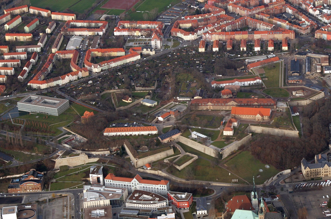
Fortifications played an important role during Erfurt's history. Nevertheless, the city wall was broken down in 1873. There are only rare artefacts of the walls today, for example the "Johannesmauer" near Franckestraße in the north-east of the city centre. More important are the two early-modern citadels of Erfurt, which remained more or less original to date.
The Petersberg Citadel is one of the biggest still existing early-modern citadels in Europe and covers the whole north-western part of the city centre. It was built after 1665 on Petersberg hill and under military use until 1963. Since 1990 it is in renovation, but in parts not finished yet.
The Cyriaksburg Citadel is a smaller early-modern citadel in the south west out of the city centre, built during the Thirty Years' War. Today, it hosts the German horticultural museum.
19th and 20th century architecture in the outskirts:
Between 1873 and 1914, a belt of Gründerzeit architecture emerged around the city centre. The mansion district in south-west around Cyriakstraße, Richard-Breslau-Straße and Hochheimer Straße hosts some interesting Gründerzeit and Art Nouveau buildings. The Bauhaus style is represented by some housing cooperative projects in the east around Flensburger Straße and Dortmunder Straße and in the north around Neuendorfstraße. An Art Deco building is the Luther's Church at Magdeburger Allee, established in 1927. A big industrial building is the former malt factory "Wolff" at Theo-Neubauer-Straße in the east of Erfurt. The complex was built between 1880 and 1939 and in use until 2000. A re-use isn't found yet, but the area is used sometimes in movie productions because of its atmosphere. Some examples of Nazi architecture are the buildings of Landtag (Thuringian parliament) and Thüringenhalle (an event hall) in the south at Arnstädter Straße. While the Landtag building (1930s) represents more the neo-Roman/fascist style, Thüringenhalle (1940s) is marked by some neo-German "Heimatschutz" style elements.
The Stalinist early-GDR style is manifested in the main building of the university at Nordhäuser Straße (1953) and the later more international modern GDR style is represented by the horticultural exhibition "Egapark" at Gothaer Straße, the Plattenbau housing complexes like Rieth or Johannesplatz and the redevelopment of Löbertor and Krämpfertor area along Juri Gagarin circular road in city centre. The current international glass and steel architecture marks the most larger new buildings like the Federal Labour Court of Germany (1999), the new opera house (2003), the new main station (2007), the university library, the fair hall and the Gunda Niemann-Stirnemann ice rink.
")
")
")
")
")
")
")
Economy and infrastructure[]
Agriculture, Industry and Services[]
Former factory building, now reused for services


Anger 1, a big department store in centre
Farming has a great tradition in Erfurt: the cultivation of woad made the city rich during the Middle Ages. Today, horticulture and the production of flower seeds is still an important business in Erfurt. Besides there is growing of fruits (like apples, strawberries and sweet cherries), vegetables (e. g. cauliflowers, potatoes, cabbage and sugar beets) and grain on more than 60% of the municipal territory.
Industrialization in Erfurt started around 1850. Until World War I, many factories were founded in different sectors like engine building, shoes, guns, malt and later electro-technics, so that there was no industrial monoculture in the city. After 1945, the companies were nationalized by the GDR government, which led collateral to the decline of some of them. After reunification, nearly all factories got closed, either because they failed the adoption of free market economy or because the German government sold them to west German businessmen who closed them to avoid competition to their own enterprises. On the other hand, the federal government started early in the 1990s to subsidize the foundation of new companies, but it took long time before the economic situation got stabilized around 2006. Since this time, unemployment decreased and overall, new jobs develop. Today, there are many small and medium-sized companies in Erfurt with electro-technics, semiconductors and photovoltaics in focus. Besides, the engine building is still an important industry same as the production of food, for example with a big noodle factory, the Braugold brewery or Born Feinkost, a producer of Thuringian mustard.
Erfurt is an Oberzentrum (which means "supra-centre" according to Central place theory) in German regional planning. Such centres are always hubs of service businesses and public services like hospitals, universities, research, trade fairs, retail etc. Additionally Erfurt is the capital of the federal state of Thuringia, so that there are many institutions of administration like all the Thuringian state ministries and some nation-wide authorities. Typical for Erfurt are the logistic business with many distribution centres of big companies, the Erfurt Trade Fair and the media sector with KiKa and MDR as public broadcast stations. A growing branch is city tourism, caused by the various historic sights of Erfurt. There are 4,800 hotel beds and (in 2012) 450,000 hotel guests with 700,000 overnight stays. Nevertheless, the larger number are one-day visitors from Germany. Just the Christmas Market in December has some 2,000,000 visitors every year.
Transport[]
Main train station
By rail[]
Erfurt is connected by the Thuringian Railway to Leipzig in the east and to Frankfurt/Kassel in the west. Furthermore there are some regional railways from Erfurt to Magdeburg via Sangerhausen, to Nordhausen, to Göttingen via Mühlhausen, to Würzburg, Ilmenau and Saalfeld via Arnstadt and to Gera via Weimar and Jena. The Erfurt Central Station was rebuilt during the 2000s for connecting the new Erfurt–Leipzig/Halle high-speed railway (will be opened in 2015) with the new Nuremberg–Erfurt high-speed railway (will be opened in 2017). With the implementation of both new railways, Erfurt will get a second ICE route, running from Berlin (then 1,5 h from Erfurt) to Munich (then 2 h from Erfurt) in addition to the existing one from Frankfurt to Dresden.
In freight transport exists an intermodal terminal in the district of Vieselbach (Güterverkehrszentrum/GVZ) with connection to rail and Autobahn.
By road[]
The two Autobahnen crossing each other nearby at Erfurt junction are the Bundesautobahn 4 (Frankfurt–Dresden) and the Bundesautobahn 71 (Schweinfurt–Sangerhausen). Together with the east tangent both motorways form a circle road around the city and lead the interregional traffic around the centre. Whereas the A 4 was built in the 1930s, the A 71 came into being after the reunification in 1990s and 2000s. In addition to both motorways exist two Bundesstraßen: the Bundesstraße 7 connects Erfurt parallel to A 4 with Gotha in the west and Weimar in the east. The Bundesstraße 4 is a connection between Erfurt and Nordhausen in the north. Its southern part to Coburg was annulled when A 71 was finished. Within the circle road, B 7 and B 4 are also annulled, so that the city government has to pay for maintenance instead of the German federal government. The access to the city is restricted as Umweltzone since 2012 for some vehicles. Big parts of the inner city are a pedestrian area which could not be reached by car (except for residents).
By light rail and bus[]
Light rail train near Anger square
The Erfurt public transport system is marked by the area-wide Erfurt Stadtbahn (light rail) network, established as a tram system in 1883, upgraded to a light rail (Stadbahn) system in 1997,[13] and continually expanded and upgraded through the 2000s. Today, there are six Stadtbahn lines running every ten minutes on every light rail route.
Additionally Erfurt operates a bus system, which connects the sparsely populated districts of the region to the city center. Both systems are organized by SWE EVAG, a transit company owned by the city administration. Trolleybuses were in service in Erfurt from 1948 until 1975, but are no longer in service.
By airplane[]
The Erfurt-Weimar Airport lies ca. 3 km (2 mi) west of city centre. It was largely extended in 1990s, but anticipations did not fulfill so that there is only rare air traffic, mostly to Mediterranean holiday regions. Other flights are carried out via Frankfurt Airport, which can be reached in 2,5 h and via Leipzig/Halle Airport, which is accessible within 1/2 h.
By bike[]
Biking is getting more and more popular since the construction of quality cycle tracks began in the 1990s. For tourism serve the Gera track and the Thuringian city string track (Radweg Thüringer Städtekette). Both connect points of tourist interest, the first along the Gera valley from Thuringian forest to Unstrut river and second near to medieval Via Regia from Eisenach via Gotha, Erfurt, Weimar and Jena to Altenburg. For inner city every-day traffic exist some cycle lanes along several main streets. Nevertheless there are – in comparison to other cities in Germany – deficits, so that cycle traffic is comparatively underrepresented in Erfurt, too because the terrain is hilly in some parts of the city.
Education[]
After the reunification, the educational system was realigned. The University of Erfurt, closed after 1816, was refounded in 1994 with a focus on humanities and teacher apprenticeship. Today there are approximately 5000 students at this university with four faculties. Another college is the Fachhochschule Erfurt, a University of Applied Sciences founded in 1991 which offers a combination of scientific training and its practical applications. There are also nearly 5000 students in six faculties, of whom the faculty of landscaping and horticulture is reputable all over Germany. A University of Applied Sciences in private ownership is the Adam-Ries-Fachhochschule, founded in 2008 with focus on business economics and more than 300 students.
Further there are eight Gymnasiums, six state-owned, one catholic and one evangelical. One of the state-owned is a Sportgymnasium, an elite boarding school for young talents in athletics, swimming, ice skating or football. Another state-owned Gymnasium offers a focus in sciences also as an elite boarding school additionally to the common curriculum.
Media[]
The Thüringer Allgemeine is headquartered in the city.[14]
Politics[]
Mayor and city council[]
The first free elected mayor after German reunification was Manfred Ruge, CDU (in office from 1990 to 2006), followed by Andreas Bausewein, SPD (in office since 2006).
The last municipal election was held in 2009 with the result:
| Party | Percentage | Seats in council |
|---|---|---|
| SPD (social democratic) | 33.0 | 17 |
| CDU (conservative) | 22.7 | 11 |
| The Left (post-socialistic left) | 19.6 | 10 |
| Greens (green) | 8.7 | 4 |
| Free Voters (citizen-oriented/populist) | 8.2 | 4 |
| FDP (classical liberal) | 5.2 | 3 |
| NPD (far-right) | 2.6 | 1 |
Twin towns[]
Erfurt is twinned with:
|
|
People from Erfurt[]
- See: List of people from Erfurt and the bdm subpage.
References[]
- ^ "Bevölkerung nach Gemeinden, erfüllenden Gemeinden und Verwaltungsgemeinschaften" (in German). Thüringer Landesamt für Statistik. 31 December 2010. http://www.statistik.thueringen.de/datenbank/TabAnzeige.asp?tabelle=gg000102%7C%7C.
- ^ Mangold, Max (2005). "Erfurt". Das Aussprachewörterbuch. Mannheim, Leipzig, Wien, Zürich: Duden Verlag. p. 311. ISBN 978-3-411-04066-7. http://www.duden.de. Retrieved 2011-06-22.
- ^ Heinemeyer, Karl (2004). "Bonifatius in Mitteldeutschland". In Hardy Eidam, Marina Moritz, Gerd-Rainer Riedel, Kai-Uwe Schierz (in German). Bonifatius: Heidenopfer, Christuskreuz, Eichenkult. Stadtverwaltung Erfurt. pp. 73–87.
- ^ Schmidt, Christoph G. (2004). "Im Machtbereich der Merowinger: Politische und gesellschaftliche Strukturen in Thüringen vom 6. bis 8. Jahrhundert". In Hardy Eidam, Marina Moritz, Gerd-Rainer Riedel, Kai-Uwe Schierz (in German). Bonifatius: Heidenopfer, Christuskreuz, Eichenkult. Stadtverwaltung Erfurt. pp. 39–56.
- ^ Stanton, Shelby, World War II Order of Battle: An Encyclopedic Reference to U.S. Army Ground Forces from Battalion through Division, 1939-1946, Stackpole Books (Revised Edition 2006), p. 150
- ^ Kottek, M. (2006). "World Map of the Köppen-Geiger climate classification updated". Meteorol. Z. 15 (3): 259–263. DOI:10.1127/0941-2948/2006/0130. Retrieved on 22 January 2013.
- ^ Peel, M. C. and Finlayson, B. L. and McMahon, T. A. (2007). "Updated world map of the Köppen–Geiger climate classification". Hydrol. Earth Syst. Sci. 11: 1633–1644. DOI:10.5194/hess-11-1633-2007. ISSN 1027-5606. (direct: Final Revised Paper)
- ^ "World Weather Information Service - Erfurt". World Meteorological Organization. http://worldweather.wmo.int/016/c01344.htm. Retrieved 22 January 2013.
- ^ Erfurt: Population 2011. Page 21-23.
- ^ According to Thüringer Landesamt für Statistik
- ^ Lehmann, Hartmut. "Weber's Protestant Ethic". Cambridge University Press, 1995. 118.
- ^ "German staging of Verdi's A Masked Ball on 9/11 with naked cast in Mickey Mouse masks". The Daily Telegraph (London). 11 April 2008. http://www.telegraph.co.uk/news/main.jhtml?xml=/news/2008/04/11/wopera111.xml. Retrieved 2 May 2010.
- ^ "Ausbau der Erfurter Straßenbahn zur Stadtbahn [Expansion of Erfurt tram to light rail]" (in German). Essener Verkehrs-Aktiengesellschaft (EVAG). https://www.stadtwerke-erfurt.de/pb/site/swegruppe/node/140107/Lde/index.html. Retrieved 2013-10-20.
- ^ "Kontakt" (Archive) Thüringer Allgemeine. Retrieved on 13 January 2014. "Zentralredaktion Thüringer Allgemeine Gottstedter Landstraße 6 99092 Erfurt"
- ^ "Kalisz Official Website - Twin Towns" (in Polish). http://www.kalisz.pl/_portal/118951340446e688bcd9fee/Miasta_partnerskie.html. Retrieved 2008-11-29.
- ^ - Kati (Mali)
External links[]
- Erfurt City Panoramas - Panoramic Views and virtual Tours
- Kraemerbruecke
- Sister City (since 1993) with Shawnee, Kansas
- World Shots. Germany. Erfurt. - Collection of photographs (English, Russian, Hebrew)
- Memorial and Museum Topf & Sons. - Builders of the Auschwitz Oven

|
Göttingen | Braunschweig — Magdeburg | Halle — Leipzig |
|
| Kassel — Eisenach | Weimar — Jena — Dresden | |||
 Erfurt | ||||
| Frankfurt — Würzburg | Bamberg Nuremberg |
Plzeň (Pilsen) (CZ) |
| ||||||||||||||
Template:Germany districts Thuringia
| ||||||||||||||||
Template:Cities in Thuringia Template:Bezirke DDR Seats
| ||||||||||||||||||||||||||||||||||||||||||||||
| This page uses content from the English language Wikipedia. The original content was at Erfurt. The list of authors can be seen in the page history. As with this Familypedia wiki, the content of Wikipedia is available under the Creative Commons License. |