Maboyce716 (talk | contribs) (Created page with "{{Infobox settlement <!-- See Template:Infobox settlement for additional fields and descriptions --> | name = Eastern Norway | native_name = Øs...") Tag: Visual edit |
({{Bdm}}{{Usedwps}}) |
||
| Line 1: | Line 1: | ||
| + | {{Bdm}}{{short description|Region of Norway}} |
||
{{Infobox settlement |
{{Infobox settlement |
||
| − | <!-- See Template:Infobox settlement for additional fields and descriptions --> |
+ | <!-- See Template:Infobox settlement for additional fields and descriptions -->| name = Eastern Norway |
| − | | |
+ | | native_name = Østlandet, Austlandet |
| − | | |
+ | | native_name_lang = no |
| ⚫ | |||
| − | | native_name_lang = no |
||
| + | | image_skyline = Østre Toten.jpg |
||
| ⚫ | |||
| − | | |
+ | | imagesize = |
| − | | |
+ | | image_alt = |
| − | | |
+ | | image_caption = |
| − | | |
+ | | image_flag = |
| − | | |
+ | | flag_size = |
| − | | |
+ | | flag_alt = |
| − | | |
+ | | image_seal = |
| − | | |
+ | | seal_size = |
| − | | |
+ | | seal_alt = |
| − | | |
+ | | image_shield = |
| − | | |
+ | | shield_size = |
| − | | |
+ | | shield_alt = |
| − | | |
+ | | image_blank_emblem = |
| − | | |
+ | | blank_emblem_type = |
| − | | |
+ | | blank_emblem_size = |
| − | | |
+ | | blank_emblem_alt = |
| − | | |
+ | | nickname = East-Norway |
| − | | |
+ | | motto = |
| − | | |
+ | | image_map = Ostlandet in Norway (plus).svg |
| − | | |
+ | | mapsize = |
| − | | |
+ | | map_alt = |
| − | | |
+ | | map_caption = |
| − | | |
+ | | latd = |
| − | | |
+ | | latm = |
| − | | |
+ | | lats = |
| − | | |
+ | | latNS = |
| − | | |
+ | | longd = |
| − | | |
+ | | longm = |
| ⚫ | |||
| ⚫ | |||
| − | | |
+ | | longEW = |
| − | | |
+ | | coor_pinpoint = |
| − | | |
+ | | coordinates_type = |
| + | | coordinates_display = |
||
| ⚫ | |||
| ⚫ | |||
| ⚫ | |||
| + | | subdivision_type = Country |
||
| ⚫ | |||
| − | | |
+ | | subdivision_name = [[Norway]] |
| − | | |
+ | | subdivision_type1 = Largest cities |
| ⚫ | |||
| − | | government_footnotes = |
||
| ⚫ | |||
| − | | government_type = |
||
| ⚫ | |||
| ⚫ | |||
| − | | |
+ | | seat_type = |
| − | | |
+ | | seat = |
| − | | |
+ | | government_footnotes = |
| − | | |
+ | | government_type = |
| − | | |
+ | | leader_party = |
| − | | |
+ | | leader_title = |
| − | | |
+ | | leader_name = |
| − | | |
+ | | leader_title1 = |
| − | | |
+ | | leader_name1 = |
| − | | |
+ | | total_type = |
| − | | |
+ | | unit_pref = |
| − | | |
+ | | area_magnitude = |
| − | | |
+ | | area_footnotes = |
| − | | |
+ | | area_total_km2 = 94577 |
| − | | |
+ | | area_total_dunam = |
| − | | |
+ | | area_land_km2 = |
| − | | |
+ | | area_water_km2 = |
| − | | |
+ | | area_water_percent = |
| + | | elevation_footnotes = |
||
| − | | population_density_km2 = 27.41 |
||
| − | | |
+ | | elevation_m = |
| − | | |
+ | | population_footnotes = |
| − | | |
+ | | population_total = 2,593,085 |
| − | | |
+ | | population_as_of = 2015 |
| − | | |
+ | | population_density_km2 = 27.41 |
| − | | |
+ | | population_est = |
| − | | |
+ | | pop_est_as_of = |
| − | | |
+ | | population_demonym = |
| − | | |
+ | | population_note = |
| − | | |
+ | | timezone1 = |
| − | | |
+ | | utc_offset1 = |
| − | | |
+ | | timezone1_DST = |
| + | | utc_offset1_DST = |
||
| ⚫ | |||
| − | | |
+ | | postal_code_type = |
| + | | postal_code = |
||
| − | | blank1_name_sec1 = [[Gross domestic product|Nominal GDP per capita (2013)]] |
||
| − | | |
+ | | area_code_type = |
| − | | |
+ | | area_code = |
| − | | |
+ | | blank_name_sec1 = [[Gross domestic product|Nominal GDP(2013)]] |
| + | | blank_info_sec1 = $0.17 trillion |
||
| ⚫ | |||
| + | | blank1_info_sec1 = $70,000 |
||
| + | | blank_name_sec2 = [[First level NUTS of the European Union#Sweden|NUTS Region]] |
||
| + | | website = |
||
| + | | footnotes = |
||
| + | | official_name = |
||
}} |
}} |
||
| Line 89: | Line 97: | ||
|1769|329041 |
|1769|329041 |
||
|1951|1584045 |
|1951|1584045 |
||
| − | |1960|1733346 |
+ | |1960|1733346 |
| − | |1970|1895148 |
+ | |1970|1895148 |
|1980|1982131 |
|1980|1982131 |
||
| − | |1990|2064971 |
+ | |1990|2064971 |
| − | |2000|2207164 |
+ | |2000|2207164 |
|2010|2430512 |
|2010|2430512 |
||
|2020|2708720 |
|2020|2708720 |
||
| − | |2030|2970713 |
+ | |2030|2970713 |
}} |
}} |
||
{{bar box |
{{bar box |
||
| Line 111: | Line 119: | ||
}} |
}} |
||
| − | '''Eastern Norway''' ([[Bokmål]]: ''Østlandet'', [[Nynorsk]]: ''Austlandet'') is the geographical [[Regions of Norway|region]] of the south-eastern part of [[Norway]]. It consists of the counties |
+ | '''Eastern Norway''' ([[Bokmål]]: ''Østlandet'', [[Nynorsk]]: ''Austlandet'') is the geographical [[Regions of Norway|region]] of the south-eastern part of [[Norway]]. It consists of the counties [[Vestfold og Telemark]], [[Viken (county)|Viken]], [[Oslo]] and [[Innlandet]]. |
Eastern Norway is by far the most populous region of Norway. It contains the country's capital, Oslo, which is Norway's most populous city. |
Eastern Norway is by far the most populous region of Norway. It contains the country's capital, Oslo, which is Norway's most populous city. |
||
| Line 141: | Line 149: | ||
The culture of mountain valleys is preserved to a greater degree than the more urbanized metropolitan areas. The area is distinguished with traditional architecture, like [[stave church]]es and [[:no:lafteverk|lafteverk]], [[Music of Norway#Folk music|folk music]] and [[Cuisine of Norway|food]]. Some are concerned for the loss of local culture in the face of modernization. There are many tourist traps, which have a tendency of becoming [[Disneyland]] versions of the actual culture, especially in the ski resorts, which are transformed by people from the cities, with increased building of shops, hotels and vacation houses. |
The culture of mountain valleys is preserved to a greater degree than the more urbanized metropolitan areas. The area is distinguished with traditional architecture, like [[stave church]]es and [[:no:lafteverk|lafteverk]], [[Music of Norway#Folk music|folk music]] and [[Cuisine of Norway|food]]. Some are concerned for the loss of local culture in the face of modernization. There are many tourist traps, which have a tendency of becoming [[Disneyland]] versions of the actual culture, especially in the ski resorts, which are transformed by people from the cities, with increased building of shops, hotels and vacation houses. |
||
| − | It is common to see moose warning signs missing from their posts, because of many tourists taking them home as a souvenir. |
+ | It is common to see moose warning signs missing from their posts, because of many tourists taking them home as a souvenir. This is of course illegal, and can result in a fine. |
The coastal region is densely populated both by Norwegian and European standards. This region was the early industrialized. Traditionally the biggest export was timber and shipping, now employment in the industrial sector is in decline and most people are working in service-oriented companies. The coastal area is varied, from the metropolitan Oslo to the more quiet and idyllic old maritime city of [[Drøbak]], and the oldest city in [[Norway]], [[Tønsberg]] |
The coastal region is densely populated both by Norwegian and European standards. This region was the early industrialized. Traditionally the biggest export was timber and shipping, now employment in the industrial sector is in decline and most people are working in service-oriented companies. The coastal area is varied, from the metropolitan Oslo to the more quiet and idyllic old maritime city of [[Drøbak]], and the oldest city in [[Norway]], [[Tønsberg]] |
||
| Line 158: | Line 166: | ||
[[Category:Regions of Norway]] |
[[Category:Regions of Norway]] |
||
| + | {{Usedwps}} |
||
Latest revision as of 12:41, 10 December 2020
| Main | Births etc |
|---|
| Eastern Norway Østlandet, Austlandet |
|
|---|---|
| — Region (landsdel) — | |
 |
|
| Nickname(s): East-Norway | |
 |
|
| Country | Norway |
| Largest cities | Drammen Fredrikstad Hamar Lillehammer Oslo Skien Sandefjord |
| Counties (fylker, fylke) |
Viken Oslo Innlandet Vestfold og Telemark |
| Area | |
| • Total | 94,577 km2 (36,516 sq mi) |
| Population (2015) | |
| • Total | 2,593,085 |
| • Density | 27.41/km2 (71.0/sq mi) |
| Nominal GDP(2013) | $0.17 trillion |
| Nominal GDP per capita (2013) | $70,000 |
| NUTS Region | |
| Historical population | ||
|---|---|---|
| Year | Pop. | ±% |
| 1769 | 329,041 | — |
| 1951 | 1,584,045 | +381.4% |
| 1960 | 1,733,346 | +9.4% |
| 1970 | 1,895,148 | +9.3% |
| 1980 | 1,982,131 | +4.6% |
| 1990 | 2,064,971 | +4.2% |
| 2000 | 2,207,164 | +6.9% |
| 2010 | 2,430,512 | +10.1% |
| 2020 | 2,708,720 | +11.4% |
| 2030 | 2,970,713 | +9.7% |
| Source: Statistics Norway [1][2][3][4][5][6][7][8][9][10][11][12][13][14][15][16]. | ||
| Religion in Eastern Norway[1][2] | ||||
|---|---|---|---|---|
| religion | percent | |||
| Christianity | 80.11% | |||
| Islam | 3.25% | |||
| Buddhism | 0.35% | |||
| Other | 16.29% | |||
Eastern Norway (Bokmål: Østlandet, Nynorsk: Austlandet) is the geographical region of the south-eastern part of Norway. It consists of the counties Vestfold og Telemark, Viken, Oslo and Innlandet.
Eastern Norway is by far the most populous region of Norway. It contains the country's capital, Oslo, which is Norway's most populous city.
In Norwegian, the region is called Østlandet and Austlandet ("The east land") in contrast to Vestlandet ("The west land").
Geography[]
As of 2015, the region had 2,593,085 inhabitants, 50.4% of Norway's population.
The region is bounded by mountains in the north and west, the Swedish border to the east and by Viken and Skagerrak to the south. The border towards Sørlandet is less obvious.
The mountains reach a height of 2469 metres in the Jotunheimen mountain range, the highest point in the Nordic countries (excluding Greenland). Other prominent mountain ranges include part of the Dovrefjell in the far north of the region, the Rondane north east of Lillehammer and others. The high plateau of Hardangervidda extends into Western Norway.
Valleys cut deep into the mountains, from east to west the main valleys are Østerdal, Gudbrandsdal, Valdres, Hallingdal, Numedal and the many valleys of Telemark. Østerdalen is surrounded by mostly flat areas of conifer forests, but the others are all deeply cut into the mountains.
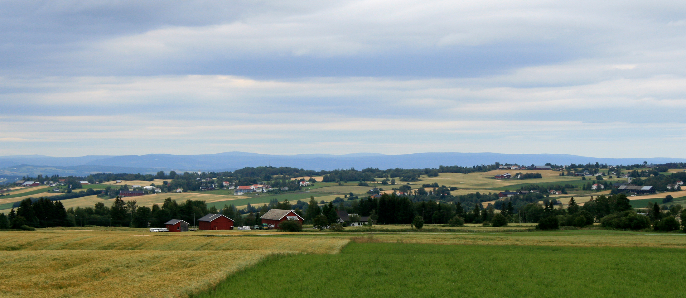
Most of eastern Norway's southern half is dominated of rolling hills with pine and spruce forests, and agricultural land down in the valleys
The area around the Oslo fjord and towards the north east are comparatively flat, and there are patches of intensely cultivated lands, notably Hedmarken, Toten, Hadeland, Ringerike and others. The population density in the flatlands is the highest in the nation, and some 40% of the nation's population lives within 200 km of Oslo. Numerous islands shelter the coasts, creating a paradise for swimmers and boaters in the summer.
Municipalities[]
People, culture and folklore[]
The Norwegian dialects spoken in the south-east share a common intonation, but there is some variation in grammar, vocabulary and pronunciation. The dialects of the interior mountainous areas (Hedmark, Oppland, and interior parts of Buskerud and Telemark) are all distinct. The dialects of the coastal areas (Telemark, Vestfold, Akershus, southern Buskerud, Oslo and Østfold) are more similar to the written language (Bokmål); in fact, Urban East Norwegian can be said to be an unofficial standard pronunciation of Bokmål.
The eastern forests of Finnskogen were the home of an ethnic minority, immigrants from Finland that came in the 17th century. Their language and culture was preserved into the 20th century, but now only folk tunes and food specialities remain. The southernmost group of Norway's Sami population is to be found in the north-eastern corner, in Engerdal.
The culture of mountain valleys is preserved to a greater degree than the more urbanized metropolitan areas. The area is distinguished with traditional architecture, like stave churches and lafteverk, folk music and food. Some are concerned for the loss of local culture in the face of modernization. There are many tourist traps, which have a tendency of becoming Disneyland versions of the actual culture, especially in the ski resorts, which are transformed by people from the cities, with increased building of shops, hotels and vacation houses.
It is common to see moose warning signs missing from their posts, because of many tourists taking them home as a souvenir. This is of course illegal, and can result in a fine.
The coastal region is densely populated both by Norwegian and European standards. This region was the early industrialized. Traditionally the biggest export was timber and shipping, now employment in the industrial sector is in decline and most people are working in service-oriented companies. The coastal area is varied, from the metropolitan Oslo to the more quiet and idyllic old maritime city of Drøbak, and the oldest city in Norway, Tønsberg
There is also some museum railway lines, for example the Krøder Line, where one can ride heritage steam and diesel trains on old twisty railway tracks.
Oslo, the capital of Norway, has attracted people from all over Norway. Most of the immigrants settle here as well. There are numerous mosques, Hindu shrines, Sikh temples, Buddhist temples, as well as many churches, giving Oslo a cosmopolitan feel.
References[]
Template:Municipalities in Norway
| |||||||
![]() East Norway travel guide from Wikivoyage
East Norway travel guide from Wikivoyage
| This page uses content from the English language Wikipedia. The original content was at Eastern Norway. The list of authors can be seen in the page history. As with this Familypedia wiki, the content of Wikipedia is available under the Creative Commons License. |