| ||||||||||||||
| Karbi Anglong district | |
|---|---|
| — District of Assam — | |
 |
|
| Country | India |
| State | Assam |
| Administrative division | Central Assam |
| Established | |
| Headquarters | Diphu |
| Government | |
| • Lok Sabha constituencies | Autonomous District |
| • Assembly seats | 4 |
| Area | |
| • Total | 10,434 km2 (4,029 sq mi) |
| Population (2011) | |
| • Total | 965,280 |
| • Density | 93/km2 (240/sq mi) |
| Demographics | |
| • Literacy | 69.25% |
| • Sex ratio | 951 |
| Vehicle registration | AS-09-X-XXXX |
| Major highways | NH-36, NH-39 |
| Coordinates | Coordinates: |
| Website | Official website |
East Karbi Anglong district (Karbi: Karbi Anglong) is one of the 33 administrative districts of Assam state in Northeastern India. The district is bounded by Golaghat district on the east, Morigaon district on the west, Nagaon and Golaghat districts on the north and Dima Hasao district and Nagaland state on the south. The district is located between 25º 33′ and 26º 35′ North latitude and from 92º 10′ to 93º 50′ East longitude. Diphu is the administrative headquarter of the district.
Etymology[]
Karbi are a tribe living in Assam. Anglong is a Karbi noun word for Hill(s), (it also refer to Mountain(s), both the noun share the same word). Literally Karbi Anglong means Hills of Karbi people.
History[]
During the pre-British rule the territory was part of the Dimasa Kingdom till the demise of Sengya Tularam Hasnu in AD 1854. After his death it went into the hands of the British under which it was declared a ‘Scheduled District’ constituted in 1874. Later, Mikir Hills tract was constituted as "Partially Excluded areas" under the Govt. of India Act, 1935. On November 17, 1951 a new district, the United Mikir Hills and North Cachar Hills district was created by combining some parts of the districts of Sibsagar (now Golaghat), Nagaon, Cachar and United Khasi and Jayantia Hills district of present-day Meghalaya state. This was followed by bifurcation of the erstwhile district of United Mikir and North Cachar Hills district into two separate districts — Mikir Hills district and North Cachar Hills district — on 2 February 1970.[1] Mikir Hills district was renamed as Karbi Anglong district on 14 October 1976.[1]
In 2016, the district was divided into two, the western part including Hamren, Baithalangso and Donkamokam and other adjoining areas forming the new district of West Karbi Anglong. Hamren is made the headquarter of the newly created district.[2][3]
Economy[]
In 2006, the Indian government named Karbi Anglong one of the country's 250 most backward districts (out of a total of 640).[4] It is one of the eleven districts in Assam currently receiving funds from the Backward Regions Grant Fund Programme (BRGF).[4]
Industry[]
- One of CCI working factory (out of three) is in Bokajan. Its product is exported to the whole country.
- Rubber
There are several Small scale industries which involves in mining and manufacturing.
Agriculture[]
Ginger[]
Karbi Anglong is known for its premium quality organic ginger. Karbi Anglong ginger has been accorded geographical indication (GI) rights by the GI Registry of India. Karbi Anglong produces the best organic ginger in the world. Growers of Karbi Anglong produce mainly two varieties of ginger-Nadia with high fibre and Aizol with less or no fibre. Aizol is more in demand and has negotiating value in domestic as well as international markets.
It is considered that the Karbi Anglong Ginger exists from the time of carving out the Karbi Anglong District of the State in 1951. Ginger is grown in Singhasan Hills, Khonbamon area. With the inception of the Ginger Growers' Cooperative Federation Ltd (GINFED), Karbi Anglong Ginger got its popularity. The demand for organic ginger produced in Karbi Anglong is phenomenal. Ginger of Karbi Anglong has found a market also in Germany.
The average annual production of ginger by the farmers of Karbi Anglong is 30,000 tonnes and about 10,000 farmers are involved in growing this item.
Administration[]
Divisions[]
The district has three sub-divisions:
- Diphu Sub-Division:
- Diphu Revenue Circle
- Phuloni Revenue Circle
- Bokajan Sub-Division:
- Bokajan Revenue Circl
- Silonijan Revenue Circle
- Howraghat Sub-Division
- Howraghat Revenue Circl
Constituency[]
The four Vidhan Sabha constituencies of the district are Bokajan, Howraghat, Diphu and Boithalangso. All are part of the 3 S.T. Autonomous District Lok Sabha constituency. Diphu town is the district headquarter. Other towns of this district are Bokajan, Dokmoka and Howraghat. Total number of villages in this district is 2633.
There are four Assam Legislative Assembly constituencies in this district: Bokajan, Howraghat, Diphu, and Boithalangso.[5] All four are designated for scheduled tribes.[5] They are all in the Autonomous District Lok Sabha constituency.[6]
Demographics[]
Template:Outdated as of
Population[]
Karbi people form the majority of the population. According to the 2011 census Karbi Anglong District has a population of 965,280,[7]
This gives it a ranking of 451st in India (out of a total of 640).[7] The district has a population density of 93 inhabitants per square kilometre (240 /sq mi) .[7] Its population growth rate over the decade 2001-2011 was 17.58%.[7] Karbi Anglong has a sex ratio of 951 females for every 1000 males,[7] and a literacy rate of 74%. with Male and Female constituting 82% and 65% respectively.[7]
Languages[]
Karbi is the prominent language in the district. Other spoken languages include Dimasa (Grao-dima), Kuki (Khawchung Thadou), Nepali, Assamese and Aiton (approximately 1500).[8]
A number of indigenous peoples reside in this district. The Karbis and the Dimasas are the most prominent amongst them. Other indigenous peoples residing in this district include the Rengmas, the Koch, the Nepali (Gorkha), the Adivasis, the Kuki-Chin People (Kukis, Hmars, Mizos), the Garos, the Tiwas, the Khasis and the Chakmas.
Religion[]
Population of the district is:
| Religion | Population |
|---|---|
| Hindus | 670,139 |
| Christians | 117,738 |
| Muslims | 18,091 |
Culture[]
Karbi anglong district has a rich culture. From ancient age the Karbi people maintain and keep their culture alive. They have their own traditional costume, like Choi Hongthor (traditional shirt) and rikong vetvot (traditional pant) for male and pini or sini and peh kok (traditional wear) for female. They also make their own traditional bag called jamborong.
Male dress[]
Choi Hongthor, the traditional shirt, is widely adopted among the Assamese culture. The shirt is very similar to a flak jacket, but with buttons in place of a zipper.
Rikong vetvot is a male attire worn from the waist to below. It is a single white piece of loincloth, approximately 5 feet in length, without decoration. It can be classified into two groups: the true rikong vetvot and the neo-modern (borrowed heavily from Dhoti). Rikong vetvot is unique in a sense how it is worn and its length. It needs skill to wear it. It is almost impossible to wear with too much length (It is still difficult to wear them with a little more length). A new wearer will find the dress slipping out as there is no knot.
Female dress[]
Pini or Sini, Peh kok and jamborong are widely famous in the state which is use by many people. Their popularity is due to their charming colours and design prepared by Karbi women.
Pini or sini is an female attire worn from the waist and covers up to the lower calf. It is similar to the dress worn by other communities like Naga, Hmar. Peh-kok is also unique in how its worn. It is a square (or similar sized) piece of cloth. Its two adjacent edge are tied into a knot (modern dress use pin in place of a knot). The knot side is then hung from the shoulder.
Others[]
Jamborong is a handbag made from cloth. It has no thong, instead it use a wide piece of cloth, similar to webbing, but wider and lesser tensile strength (depend on the strength of cloth). Its size can vary. Smaller ones are similar to a woman's purse.
Tourism[]
Places of interest[]
A hilly district of Assam Karbi Anglong is a very beautiful place in the lap of nature. It is still somewhat unknown to the tourist in spite of its enchanting natural green forests and picturesque hills. In addition to this there are the multi-coloured cultures and traditions.
- Diphu
- It is a small but very charming busy town. The town is located on a hill.
- Silbheta
- It is a favourite picnic spot located at a distance of 37 km from Diphu. The place surrounded by rain forests. A nature built stone bridge is also there.
- Akashiganga
- 65 km away from Diphu, here a divine stream of water flows down from the high hill. In front of it there is a great siva temple.
- Garampani
- Garampani Wildlife Sanctuary which is home of hollock gibbon and golden langur. There is hot water spring in here near the national highway.
- Dikrut Waterfall (Paklongkam)
- It's a waterfall located into the bosom of mountain.
- Kathilangso Waterfall
- It's a waterfall located in Kanthi village, around 12 km from Denarong (Dengaon) along NH 36.
- Longsokangthu (Siloni)
- It is a picnic spot on the bank of a river, surrounded by hills and greenary.
Flora and fauna[]
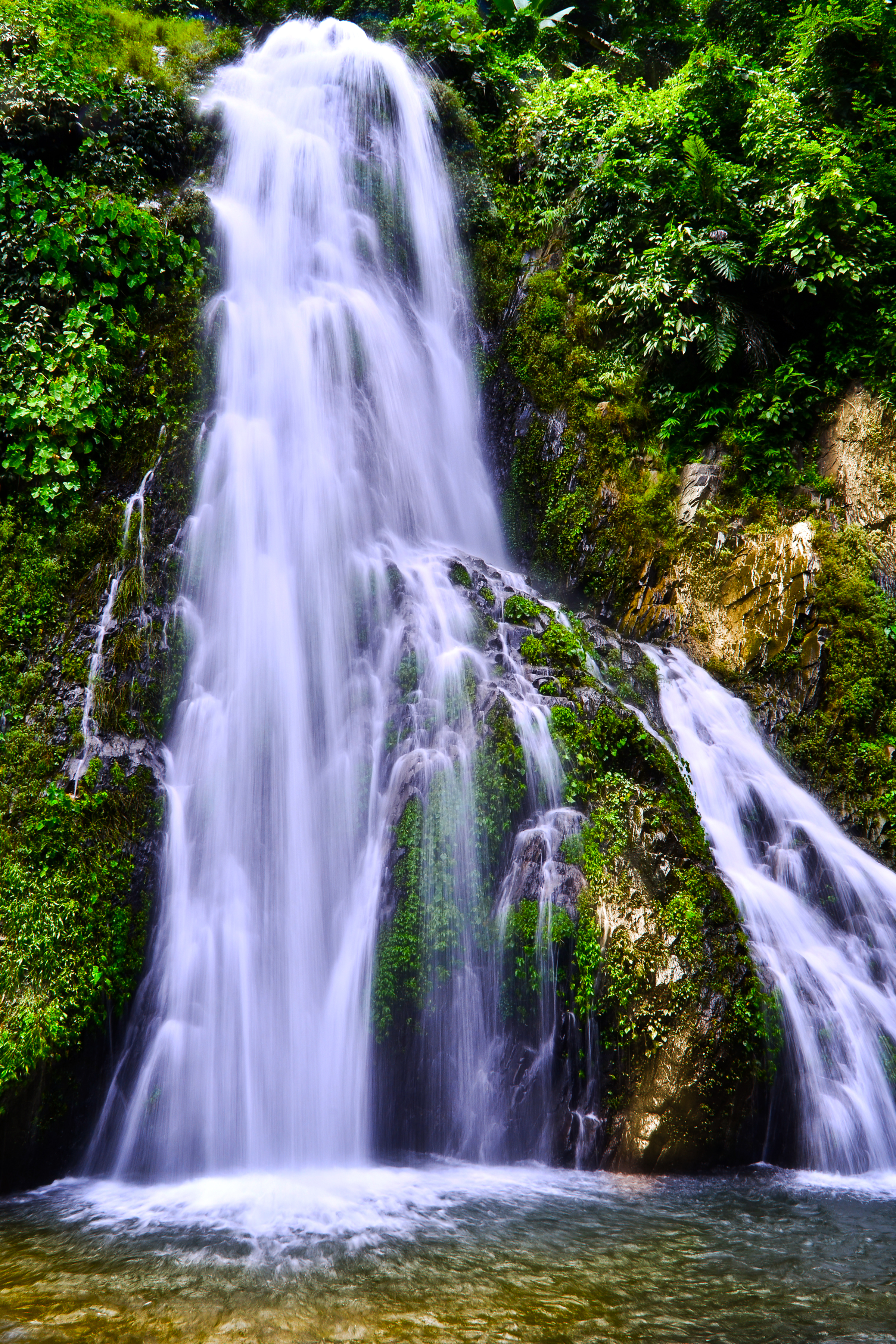
The scenic beauty of Kanthi waterfall, situated in Kanthi Village, some 12 kilometers away from Dengaon in Karbi Anglong district of Assam in India.
In 1952, Karbi Anglong district became home to the Garampani Wildlife Sanctuary, which has an area of 6 km2 (2.3 sq mi).[9] Nambor Wildlife Sanctuary is another wildlife sanctuary of Karbi Anglong covering 37 km2.
For any visitor to Karbi Anglong, a must read book is A Naturalist in Karbi Anglong by Assam's well known naturalist Dr. Anwaruddin Choudhury. He narrated his travels and wildlife observations in different parts of Karbi Anglong during his tenure in the district as a civil servant. The book is profusely illustrated with drawings and photos.[10][11]
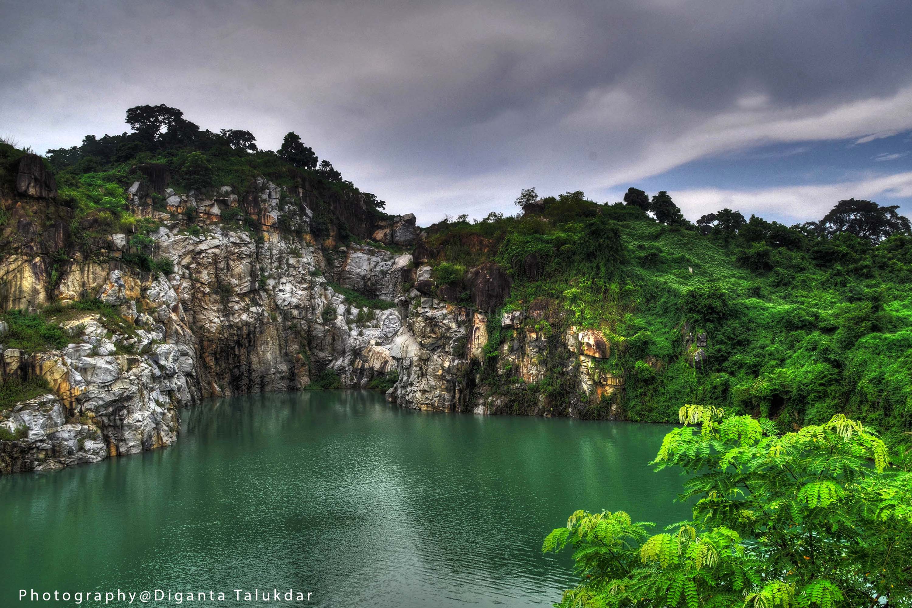
The landscape beauty of Blue water lake at Kathalguri village in Karbi Anglong district of Assam.
More than 75% of the district is forested. The main vegetation is Tropical semi-evergreen with patches of Moist Deciduous and wet Evergreen forests in certain areas. The district boasts the largest population of hoolock gibbons in Assam.
The district has a Wildlife sanctuary.
Education[]
Karbi Anglong is home to a variety of educational institutions.
Universities[]
- Assam University, Diphu Campus.
Colleges[]
- Diphu Government College, Diphu
- Diphu Law College, Diphu
- Don Bosco Junior College, Manja
- Eastern Karbi Anglong College, Bokajan
- Junior College, Howraghat.
- Rukasen College, Bakaliaghat
- Thong Nokbe College, Dokmoka
Technical institutes[]
- Industrial Training Institute, Diphu.
- Polytechnic, Diphu.
Schools[]
- Aturkimi Academy, Diphu.
- Calvery Home Academy,Diphu
- D.A.V. Higher Secondary School, Diphu.
- Diphu Govt. Boys Higher Secondary School, Diphu
- Diphu Govt. Girls High School, Diphu.
- Don Bosco Higher Secondary School, Diphu.
- Don Bosco School, Satgaon.
- Howraghat English Medium School, Howraghat
- Howraghat Higher Secondary School, Howraghat
- Jawahar Navodaya Vidyalaya, Diphu.
- Jawahar Navodaya Vidyalaya, Dongkamukam.
- Kendriya Vidyalaya, Bokajan.
- Kendriya Vidyalaya, Diphu.
- Kidzee, Diphu.
- Krist Jyoti School, Dokmoka.
- Mount Calvary English High School, Diphu.
- Mount Calvery,Diphu
- National English School, Howraghat
- Presbyterian Mission High School, Diphu.
- Rengbonghom Higher Secondary School, Diphu.
- Srimanta Shankardev Niketan, Howraghat
- St. Mary's High School , Diphu
- Vidya Sagar High School, Bokajan.
- Vivekananda H.S School, Bokajan.
Media[]
Newspaper[]
Karbi Anglong is popular for its fast growing media. The Arleng Daily, a Karbi daily, is the newspaper that heralded a new beginning for Karbi newspaper. it's also the newspaper that brought the importance and power of media to the people. Thekar, a Karbi daily, is the highest circulated daily and the first RNI Registered Karbi newspaper. Since then, there are several dailies in Karbi language. In the year of 2005-06, a Hindi newspaper Jana Prahari was launched from bokuliaghat, a small town in Karbi Anglong.
Television[]
- Doordarshan TV relay centre, Diphu
- ((KAT NEWS Channel))Local Cable Channel, Diphu
Radio[]
- All India Radio, Diphu
Notable towns[]
- Amlakhi
- Bokajan
- Bokulia
- Chokihola
- Diphu
- Dokmoka
- Howraghat
- Manja
- Samelangso
- Tumpung
Notable Personalities[]
- Prof. Rongbong Terang, Padmashree awardee.
- Late Semsonsing Ingti, founder of Karbi Anglong district.
- Jayanta Rongpi
- Biren Sing Engti
- Joyram Engleng
See also[]
- West Karbi Anglong district
References[]
- ^ a b Law, Gwillim (2011-09-25). "Districts of India". Statoids. http://www.statoids.com/yin.html. Retrieved 2011-10-11.
- ^ "Assam get new districts"
- ^ "West Karbi Anglong district inaugurated", The Assam Tribune, February 11, 2016
- ^ a b Ministry of Panchayati Raj (September 8, 2009). "A Note on the Backward Regions Grant Fund Programme". National Institute of Rural Development. Archived from the original on April 5, 2012. https://web.archive.org/web/20120405033402/http://www.nird.org.in/brgf/doc/brgf_BackgroundNote.pdf. Retrieved September 27, 2011.
- ^ a b "List of Assembly Constituencies showing their Revenue & Election District wise break - up". Chief Electoral Officer, Assam website. Archived from the original on 22 March 2012. https://web.archive.org/web/20120322074811/http://ceoassam.nic.in/Gen_Informations/2.1%20-%20DEOs%20wise%20ACs%20breakup.pdf. Retrieved 26 September 2011.
- ^ "List of Assembly Constituencies showing their Parliamentary Constituencies wise break - up". Chief Electoral Officer, Assam website. Archived from the original on 22 March 2012. https://web.archive.org/web/20120322074903/http://ceoassam.nic.in/Gen_Informations/2.2%20-%20PC-wise%20LAC%20breakup.pdf. Retrieved 26 September 2011.
- ^ a b c d e f "District Census 2011". Census2011.co.in. 2011. http://www.census2011.co.in/district.php. Retrieved 2011-09-30.
- ^ M. Paul Lewis, ed (2009). "Aiton: A language of India". Ethnologue: Languages of the World (16th ed.). Dallas, Texas: SIL International. http://www.ethnologue.com/show_language.asp?code=aio. Retrieved 2011-09-28.
- ^ Indian Ministry of Forests and Environment. "Protected areas: Assam". Archived from the original on August 23, 2011. https://web.archive.org/web/20110823163836/http://oldwww.wii.gov.in/envis/envis_pa_network/index.htm. Retrieved September 25, 2011.
- ^ Choudhury, A.U. (1993). A Naturalist in Karbi Anglong. Gibbon Books, Guwahati, India.88pp+maps.
- ^ Choudhury, A.U. (2009). A Naturalist in Karbi Anglong. Revised 2nd edn. Gibbon Books, Guwahati, India.152pp.
External links[]

|
Golaghat district |
| ||
| Nagaon district | Dimapur district, Nagaland | |||
 Karbi Anglong District (East) | ||||
| Dima Hasao district | Peren district, Nagaland |
| ||||||||||||||
Template:Autonomous Areas of Northeast India Template:Proposed states and territories of India
| This page uses content from the English language Wikipedia. The original content was at East Karbi Anglong district. The list of authors can be seen in the page history. As with this Familypedia wiki, the content of Wikipedia is available under the Creative Commons License. |