| Main | Births etc |
|---|
| ||||||||||||||
| Dutchess County, New York | |
 Location in the state of New York (state) | |
 New York's location in the U.S. | |
| Founded | 1683 |
|---|---|
| Seat | Poughkeepsie |
| Area - Total - Land - Water |
825 sq mi (2,137 km²) 802 sq mi (2,077 km²) 24 sq mi (62 km²), |
| Population - (2020) - Density |
295,911 371/sq mi (143.2/km²) |
| Website | www.co.dutchess.ny.us |
Dutchess County is a county located in the U.S. state of New York, in the state's Mid-Hudson Region of the Hudson Valley. The 2020 census lists the population as 295,911. The county seat is Poughkeepsie.
Dutchess County is part of the Poughkeepsie–Newburgh–Middletown, NY Metropolitan Statistical Area as well as the larger New York–Newark–Bridgeport, NY-NJ-CT-PA Combined Statistical Area. It is the northmost county in the New York Metropolitan area.
History[]
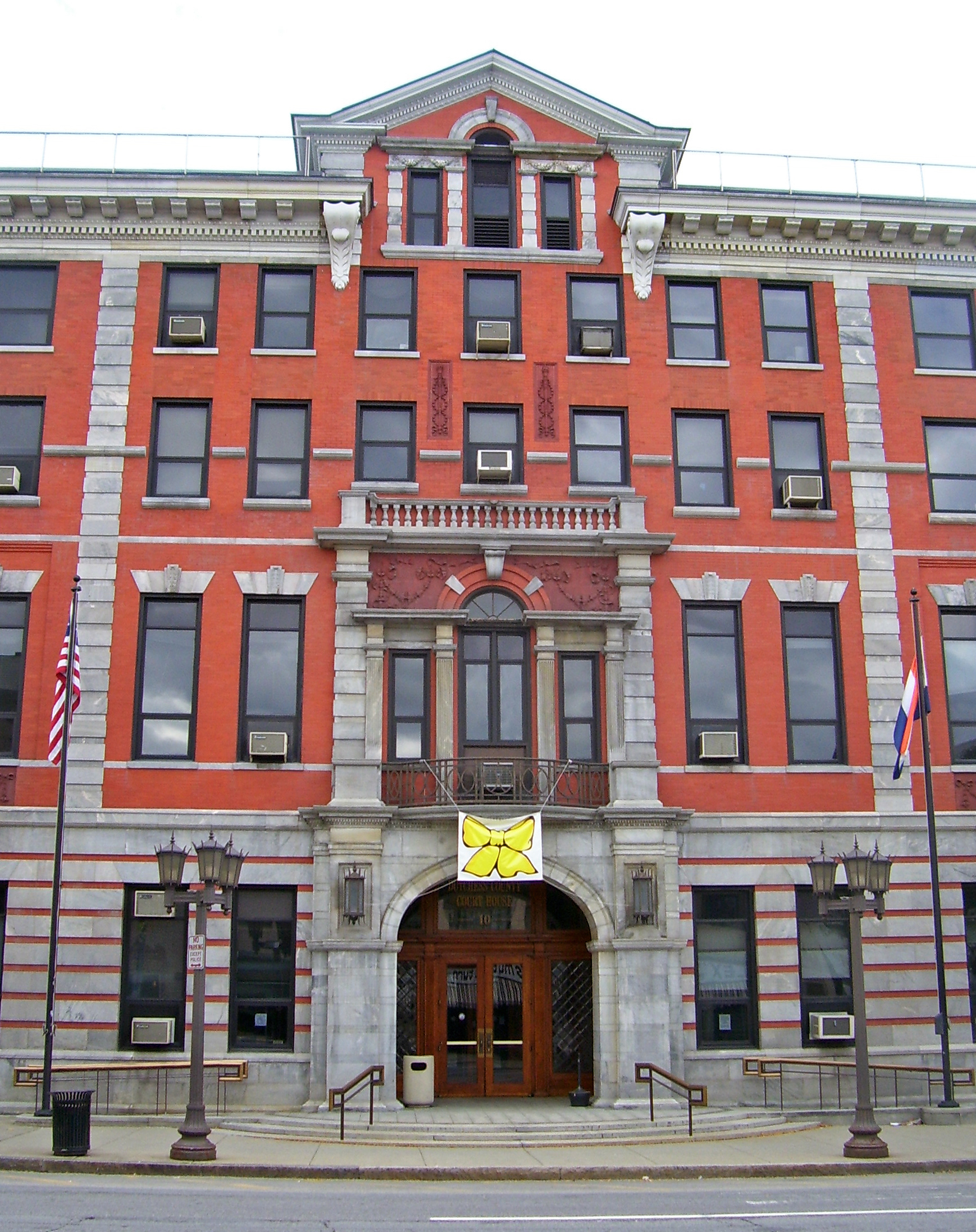
The current county courthouse, built in 1903, stands on the same site as the original 1720 building.
Prior to Anglo-Dutch settlement, what is today Dutchess County was a leading center for the native Wappinger peoples. They had their council-fire at what is now present-day Fishkill Hook and also held gatherings along the Danskammer.[1]
In 1683, the Province of New York established its first twelve counties, with Dutchess County being one of them. Its boundaries at that time included the present Putnam County, and a small portion of the present Columbia County (the towns of Clermont and Germantown). The county was named for Mary of Modena, Duchess of York, second wife of James, Duke of York (later James II, King of England).
Until 1713, Dutchess was administered by Ulster County.
In 1812, Putnam County was detached from Dutchess.
The patents[]
In the twelve years 1685-1697 lawful patents had been granted securing for their purchasers every foot of Hudson River shoreline in the original county. Three additional patents, to 1706, laid claim to the remaining interior lands.
- 1685 Rombout (Beacon/ Fishkill Area)
- 1686 Minisink
- 1686 Kip
- 1688 Schuyler (Poughkeepsie)
- 1688 Schuyler (Red Hook)
- 1688 Ærtsen-Roosa-Elton
- 1696 Pawling-Staats
- 1697 Rhinebeck
- 1697 (Great) Nine Partners
- 1697 Philipse
- 1697 Cuyler
- 1703 Fanconnier
- 1703 Beekman (Back Lots)
- 1706 (Little) Nine Partners
Early settlement[]
From 1683-1725 most of the settlers in Dutchess County were Dutch. Many of these moved in from Albany and Ulster Counties. They settled along the Fishkill River and in the areas that are now Poughkeepsie and Rhinebeck.[2]
From 1715-1730 most of the new settlers in Dutchess county were Germans. From 1730 until 1775 New Englanders were the main new settlers in Dutchess County.[3]
20th century[]
Franklin D. Roosevelt lived in his family home in Hyde Park, overlooking the Hudson River.
In the 1960s G. Gordon Liddy (who went to prison for crimes committed during the Nixon administration's Watergate scandal and now a talk show host), was a Dutchess County assistant district attorney when he repeatedly tried to have Timothy Leary arrested on drug charges. By the 1980s, the two ex-cons went on a speaking tour together.
Prior to the 1960s, Dutchess County was primarily agricultural. Since then the southern part (from Poughkeepsie south) of the county has developed into a largely residential area, suburban in character, with many of its residents commuting to jobs in New York City. The northern region of the county is still very much rural with large farmlands but at the same time developed residences used during the summer and or on weekends by people living in the New York City urban area.[4]
Geography[]
Dutchess County is located in southeastern New York State, between the Hudson River on its west and the New York-Connecticut border on its east, about halfway between the cities of Albany and New York. It contains two cities: Beacon and Poughkeepsie.
According to the U.S. Census Bureau, the county has a total area of 825 square miles (2,136.7 km2), of which 802 square miles (2,077.2 km2) is land and 24 square miles (62.2 km2) (2.88%) is water.
The terrain of the county is mostly hilly, especially in the Hudson Highlands in the southwestern corner and the Taconic Mountains to the northeast. Some areas nearer the river are flatter.
The highest point in the county is the summit of Brace Mountain, in the Taconics, at 2,311 feet (704 m) above sea level. The lowest point is sea level, along the Hudson River.
Adjacent counties[]
- Columbia County, New York, north
- Berkshire County, Massachusetts, northeast
- Litchfield County, Connecticut, east
- Fairfield County, Connecticut, southeast
- Putnam County, New York, south
- Orange County, New York, southwest
- Ulster County, New York, west
National protected areas[]
- Eleanor Roosevelt National Historic Site
- Home of Franklin D. Roosevelt National Historic Site
- Vanderbilt Mansion National Historic Site
State, county, and town parks[]
- Bowdoin County Park
- Hudson Highlands State Park
- Stratt Town Park
- Wilcox County Park
- Tymor Forest
- Taconic State Park
- Beekman Rec
- East Fishkill Rec
- James Baird State Park
- Poughkeepsie Bridge
Demographics[]
| Historical populations | |||
|---|---|---|---|
| Census | Pop. | %± | |
| 1790 | 45,276 | ||
| 1800 | 47,775 | 5.5% | |
| 1810 | 51,363 | 7.5% | |
| 1820 | 46,615 | −9.2% | |
| 1830 | 50,926 | 9.2% | |
| 1840 | 52,398 | 2.9% | |
| 1850 | 58,992 | 12.6% | |
| 1860 | 64,941 | 10.1% | |
| 1870 | 74,041 | 14.0% | |
| 1880 | 79,184 | 6.9% | |
| 1890 | 77,879 | −1.6% | |
| 1900 | 81,670 | 4.9% | |
| 1910 | 87,661 | 7.3% | |
| 1920 | 91,747 | 4.7% | |
| 1930 | 105,462 | 14.9% | |
| 1940 | 120,542 | 14.3% | |
| 1950 | 136,781 | 13.5% | |
| 1960 | 176,008 | 28.7% | |
| 1970 | 222,295 | 26.3% | |
| 1980 | 245,055 | 10.2% | |
| 1990 | 259,462 | 5.9% | |
| 2000 | 280,150 | 8.0% | |
| 2010 | 297,488 | 6.2% | |
| Source[5] | |||
In 1990 Dutchess County had a population of 259,462.[6]
As of the census[7] of 2000, there were 280,150 people, 99,536 households, and 69,177 families residing in the county. The population density was 350 people per square mile (135/km²). There were 106,103 housing units at an average density of 132 per square mile (51/km²). The racial makeup of the county was 83.66% White (80.3% non-Hispanic whites),[8] 9.32% Black or African American, 0.22% Native American, 2.52% Asian, 0.03% Pacific Islander, 2.37% from other races, and 1.89% from two or more races. 6.45% were Hispanic or Latino of any race. 22.0% were of Italian, 16.9% Irish, 11.3% German and 6.7% English ancestry according to Census 2000. 88.3% spoke English and 4.8% Spanish
Based on the Census Ancestry tallies, including people who listed more than one ancestry, Italians were the largest group in Dutchess County with 60,645. Irish came in a very close second at 59,991. In third place were the 44,915 Germans who barely exceeded the 44,078 people not in the 105 specifically delineated ancestry groups.[9]
6.45% of the population were Hispanic or Latino of any race. Puerto Ricans made up the largest portion of Latinos, with 2.9% of the total county population. 2.1% of the county population was in the category "other Hispanic or Latino".[8] The other Hispanics and Latinos were a varied group. About 700 were born in the Dominican Republic, while people born in Colombia or Ecuador slightly exceeded 800. Costa Rica, El Salvador and Panama all had more than 100 natives in Dutchess County. There were 1,685 people in the county born in Mexico but they were exceeded by the total 1,894 born in South America.[10]
There were 99,536 households out of which 34.50% had children under the age of 18 living with them, 55.50% were married couples living together, 10.30% had a female householder with no husband present, and 30.50% were non-families. 24.60% of all households were made up of individuals and 9.00% had someone living alone who was 65 years of age or older. The average household size was 2.63 and the average family size was 3.16.
In the county the population was spread out with 25.10% under the age of 18, 9.40% from 18 to 24, 30.20% from 25 to 44, 23.20% from 45 to 64, and 12.00% who were 65 years of age or older. The median age was 37 years. For every 100 females there were 100.10 males. For every 100 females age 18 and over, there were 98.20 males.
The median income for a household in the county was $53,086, and the median income for a family was $63,254. Males had a median income of $45,576 versus $30,706 for females. The per capita income for the county was $23,940. About 5.00% of families and 7.50% of the population were below the poverty line, including 8.50% of those under age 18 and 6.50% of those age 65 or over.
The per capita income and average home values have increased noticeably in recent years mainly due to affluent residents relocating from nearby and expensive Westchester County, NY. In recent years, there has been a large influx of people that have relocated from New York City, mainly from the Borough of The Bronx.
The decrease in population between 1810 and 1820 was due the separation of Putnam County from Dutchess in 1812.
Government and politics[]
| Year | Republican | Democratic | Third party | |||
|---|---|---|---|---|---|---|
| No. | % | No. | % | No. | % | |
| 2020 | 66,872 | 44.25% | 81,443 | 53.89% | 2,807 | 1.86% |
| 2016 | 61,821 | 47.19% | 62,285 | 47.54% | 6,912 | 5.28% |
| 2012 | 56,025 | 45.29% | 65,312 | 52.80% | 2,368 | 1.91% |
| 2008 | 59,628 | 45.07% | 71,060 | 53.71% | 1,614 | 1.22% |
| 2004 | 63,372 | 51.16% | 58,232 | 47.01% | 2,277 | 1.84% |
| 2000 | 52,669 | 47.12% | 52,390 | 46.87% | 6,712 | 6.01% |
| 1996 | 41,929 | 40.39% | 47,339 | 45.60% | 14,553 | 14.02% |
| 1992 | 46,709 | 40.50% | 41,655 | 36.12% | 26,964 | 23.38% |
| 1988 | 62,165 | 60.97% | 38,968 | 38.22% | 826 | 0.81% |
| 1984 | 70,324 | 67.89% | 32,867 | 31.73% | 389 | 0.38% |
| 1980 | 53,616 | 57.65% | 28,616 | 30.77% | 10,775 | 11.59% |
| 1976 | 51,312 | 56.94% | 37,531 | 41.65% | 1,268 | 1.41% |
| 1972 | 64,864 | 69.82% | 27,872 | 30.00% | 167 | 0.18% |
| 1968 | 45,032 | 54.87% | 31,025 | 37.80% | 6,010 | 7.32% |
| 1964 | 29,503 | 37.01% | 50,179 | 62.94% | 43 | 0.05% |
| 1960 | 46,109 | 60.67% | 29,842 | 39.26% | 53 | 0.07% |
| 1956 | 53,840 | 78.35% | 14,876 | 21.65% | 0 | 0.00% |
| 1952 | 46,381 | 71.17% | 18,644 | 28.61% | 142 | 0.22% |
| 1948 | 34,067 | 64.23% | 17,439 | 32.88% | 1,533 | 2.89% |
| 1944 | 32,890 | 58.92% | 22,778 | 40.80% | 158 | 0.28% |
| 1940 | 32,329 | 55.69% | 25,598 | 44.10% | 122 | 0.21% |
| 1936 | 28,868 | 53.12% | 24,467 | 45.02% | 1,010 | 1.86% |
| 1932 | 25,757 | 54.95% | 20,374 | 43.47% | 740 | 1.58% |
| 1928 | 28,687 | 61.30% | 16,748 | 35.79% | 1,366 | 2.92% |
| 1924 | 22,173 | 64.64% | 8,864 | 25.84% | 3,266 | 9.52% |
| 1920 | 21,152 | 65.60% | 9,938 | 30.82% | 1,156 | 3.58% |
| 1916 | 11,082 | 54.60% | 8,906 | 43.88% | 310 | 1.53% |
| 1912 | 8,916 | 43.65% | 8,871 | 43.43% | 2,638 | 12.92% |
| 1908 | 11,132 | 53.58% | 8,961 | 43.13% | 682 | 3.28% |
| 1904 | 11,709 | 57.06% | 8,275 | 40.32% | 537 | 2.62% |
| 1900 | 11,936 | 59.39% | 7,691 | 38.27% | 471 | 2.34% |
| 1896 | 12,127 | 62.44% | 6,634 | 34.16% | 661 | 3.40% |
| 1892 | 9,376 | 48.09% | 8,978 | 46.05% | 1,141 | 5.85% |
| 1888 | 10,265 | 50.95% | 9,249 | 45.91% | 634 | 3.15% |
| 1884 | 9,701 | 51.13% | 8,677 | 45.73% | 596 | 3.14% |
The composition of the County Legislature is 15 Republicans and 10 Democrats for the 2019–2021 term. County elections occur in odd-numbered years.[12]
Historically, Dutchess County, like most of the lower Hudson, was classic "Yankee Republican" territory. Between 1884 and 2004, the Republican presidential candidate carried Dutchess County in 28 out of 30 elections (1964 and 1996 being exceptions). As a measure of how Republican the county was during this time, Hyde Park resident Franklin D. Roosevelt lost Dutchess County (but won New York) during his four successful bids for president.
The Republican edge narrowed significantly in the 1990s, with George H. W. Bush going from 61 percent of the county's vote in 1988 to only 40.5 percent in 1992. In 2008, Barack Obama became only the third Democrat to carry the county since 1884, and the first to win a majority since Lyndon Johnson in 1964. It has gone for the Democratic candidate in four consecutive elections (2008, 2012, 2016, and 2020).
Dutchess County is split between two congressional districts. The more populated southern portion is in the 18th district, represented by Democrat Sean Patrick Maloney. The northern portion is in the 19th district, represented by Democrat Antonio Delgado. These are considered "swing" districts nationally, with Cook Partisan Voting Index ratings of R+1 and R+2, respectively, as of 2019.
Law enforcement[]
The Cities of Beacon and Poughkeepsie; Towns of Hyde Park, Poughkeepsie, Rhinebeck, Red Hook, and East Fishkill and Village of Wappingers have their own Police departments. The remainder of the county is patrolled by the Dutchess County Sheriff's Office and New York State Police. The New York State Police Troop K headquarters is located in Pleasant Valley.
Transportation[]
Highways[]
- Interstate 84 traverses the county in an east-west route cutting through the southern quadrant of the county. It is the only interstate highway in the county.
- US 9, the Taconic State Parkway, and NY 22 are the main north-south roads in the county.
- US 44, NY 55, and NY 199 are the other main east-west roads in the county
Railroads[]
Amtrak has stations in Rhinecliff, a small hamlet in the Town of Rhinebeck, and Poughkeepsie, with both stations being served by Empire Service trains as well as other trains that run along the line. The latter station is the terminus of the Hudson Line of the Metro-North Railroad. The Hudson Line also has station stops in New Hamburg (a hamlet of the town of Poughkeepsie) and Beacon.
The Harlem Line, on the eastern side of the county, has station stops in Pawling, Wingdale, Dover Plains, and two stops in Wassaic (one along the Tenmile River and the other the namesake terminus of that line).
Buses[]
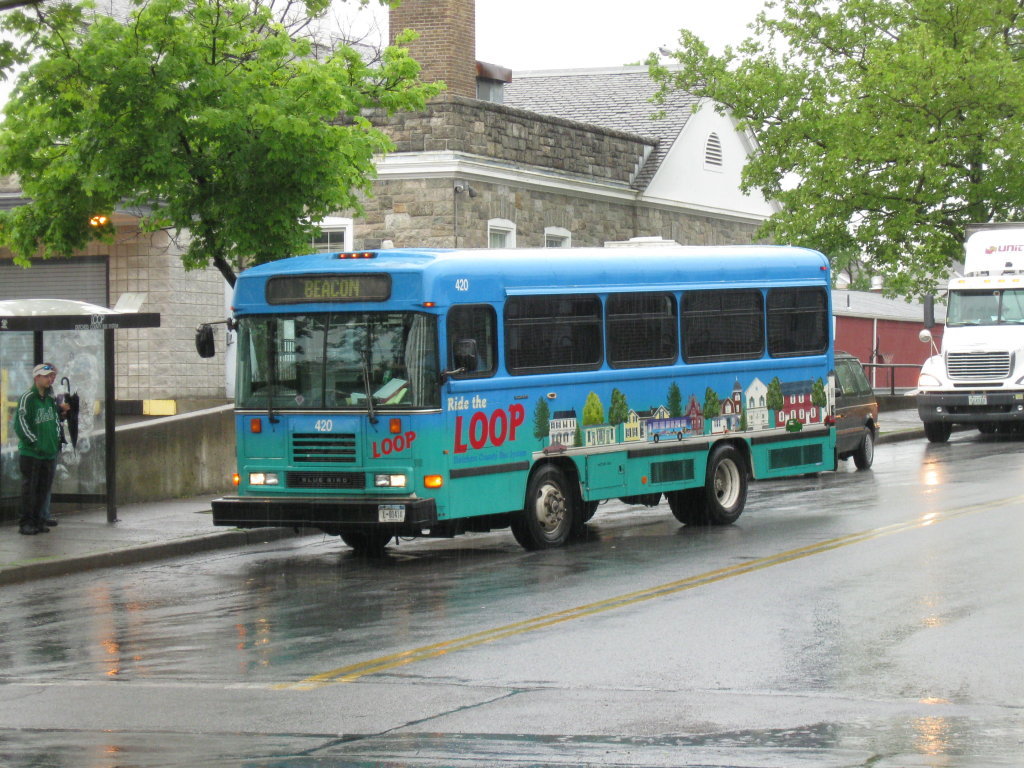

Dutchess County LOOP bus
Public transportation in Dutchess County is handled by the Dutchess County Department of Mass Transit, branded publicly as the LOOP system. Outside of the urbanized area of the county, most service is limited. The City of Poughkeepsie operates its own limited system as well. Privately run lines connect Poughkeepsie to New Paltz and Beacon to Newburgh.
For intercity bus service, Adirondack Trailways and Short Line Bus also operate some service through Poughkeepsie, Rhinebeck, and the southern part of the county. The last time service ran outside that area was in the late-1990s when Peter Pan/Bonanza ran service to New York City in the eastern part of the county.
Air[]
The Dutchess County Airport, located in the town of Wappinger, is a general aviation facility which once had commercial service. The closest commercial airport, Stewart International Airport, is located across the Hudson River in Newburgh.
Sports[]
The Hudson Valley Renegades are a minor league baseball team affiliated with the Tampa Bay Rays. The team is a member of the New York - Penn League, and play at Dutchess Stadium in Fishkill.
The Hudson Valley Bears are one of four founding members of the Eastern Professional Hockey League (EPHL). They play their home games at the Mid-Hudson Civic Center in Poughkeepsie.
The Hudson Valley Hawks is a team in the newly formed National Professional Basketball League. The team's home court is at Beacon High School, in Beacon.
Communities[]
Cities[]
Defined by the State of New York
- Beacon
- Poughkeepsie
Towns[]
Defined by the State of New York
- Amenia
- Beekman
- Clinton
- Dover
- East Fishkill
- Fishkill
- Hyde Park
- La Grange
- Milan
- North East
- Pawling
- Pine Plains
- Pleasant Valley
- Poughkeepsie
- Red Hook
- Rhinebeck
- Stanford
- Union Vale
- Wappinger
- Washington
Villages[]
Defined by the State of New York
- Fishkill
- Millbrook
- Millerton
- Pawling
- Red Hook
- Rhinebeck
- Tivoli
- Wappingers Falls
Hamlets[]
Defined by the State of New York
- Annandale-on-Hudson
- Arlington
- Arthursburg
- Attlebury
- Bangall
- Bear Market
- Brinckerhoff
- Barnegat
- Barrytown
- Crown Heights
- De Witt Mills
- Dover Plains
- Fairview
- Fishkill Plains
- Gayhead
- Fishkill
- Gretna
- Haviland
- Hillside Lake
- Holmes
- Hopewell Junction
- Hortontown
- Hughsonville
- Johnsontown
- Knapps Corner
- Lomala
- McIntyre
- Myers Corner
- New Hackensack
- New Hamburg
- Norrie Heights
- Oniontown
- Pecksville
- Pleasant Plains
- Poughquag
- Red Oaks Mill
- Rhinecliff
- Rudco
- Salt Point
- Shenandoah
- Shekomeko
- Spackenkill
- Staatsburg
- Stanfordville
- Stissing
- Stormville
- Wassaic
- Washington Hollow
- Wiccopee
- Willow Brook
- Wingdale
- Van Keurens
- Cities, Towns and Villages are official political designations.
| North: Columbia County | ||
| West: Hudson River Orange and Ulster Counties |
Dutchess County | East: Fairfield and Litchfield Counties in Connecticut* |
| South: Putnam County |
*: There is also a northern border of about 0.5 miles (0.8 km) in length with Berkshire County, Massachusetts, however this is in a forested area in Taconic State Park and there is no direct road access from Dutchess County to Berkshire County.
Colleges, universities, etc.[]
- Adelphi University School of Social Work Poughkeepsie
- Bard College (Annandale-on-Hudson)
- Culinary Institute of America (Hyde Park)
- Dutchess Community College (Poughkeepsie)
- Marist College (Poughkeepsie)
- Ridley-Lowell Business & Technical Institute (Poughkeepsie)
- Vassar College (Poughkeepsie)
Public school districts[]
- Arlington Central School District
- Beacon City School District
- Dover Union Free School District
- Hyde Park Central School District
- Millbrook Central School District
- Pawling Central School District
- Pine Plains Central School District
- Poughkeepsie City School District
- Red Hook Central School District
- Rhinebeck Central School District
- Spackenkill Union Free School District
- Wappingers Central School District
- Webutuck Central School District
- Dutchess County BOCES
Private schools[]
- Oakwood Friends School
- Our Lady of Lourdes High School
- Poughkeepsie Day School
- Dutchess Day School
- Millbrook School
- Trinity-Pawling School
- Tabernacle Christian Academy
- Upton Lake Christian School
See also[]
- List of counties in New York
- National Register of Historic Places listings in Dutchess County, New York
- Upstate New York
References[]
- ^ MacCraken, Henry Noble, Old Dutchess Forever! The Story of An American County. (New York: Hastings House, 1956) p. 3
- ^ Pucher, J. Wilson and Helen Wilkinson Reynolds, Old Gravestones of Dutchess County, New York (Poughkeepsie: Dutchess County Historical Society, 1924) p. xi
- ^ Pulcher and Reynolds. Old Gravestones. p. xi
- ^ Hobson, Archie, ed., The Cambridge Gazeteer of the United States and Canada (New York:Cambridge University Press, 1995) p. 183-184
- ^ New York State Department of Economic Development
- ^ Census Population Finder: Dutchess County
- ^ "American FactFinder". United States Census Bureau. http://factfinder.census.gov. Retrieved 2008-01-31.
- ^ a b Census fact sheet, Dutchess County, 2000 census data
- ^ American fact finder chart on Ancesties for Dutchess County, New York
- ^ Census table on immigrant origins
- ^ Leip, David. "Dave Leip's Atlas of U.S. Presidential Elections". http://uselectionatlas.org/RESULTS.
- ^ "Dutchess County, NY County Legislature". eCode 360. https://ecode360.com/31910930.
External links[]
- Dutchess County official webpage
- Early history summary of Dutchess County
- Historic Towns of Dutchess County
- Dutchess County at the Open Directory Project
Further reading[]
- MacCracken, Henry Noble. Old Dutchess Forever!, New York: Hastings House, ©1956. LC 56-12863
- Smith, James H. History of Dutchess County, New York, Syracuse, New York: 1882. Reprinted: Interlaken, New York: Heart of the Lakes Publishing. ISBN 0-932334-35-0

|
Columbia County | Berkshire County, Massachusetts |
| |
| Ulster County | Litchfield County, Connecticut | |||
 Dutchess County, New York | ||||
| Orange County | Putnam County | Fairfield County, Connecticut |
| ||||||||||||||||||||||||||

| ||||||||||||||||||||

| ||||||||||||||||||||||
| This page uses content from the English language Wikipedia. The original content was at Dutchess County, New York. The list of authors can be seen in the page history. As with this Familypedia wiki, the content of Wikipedia is available under the Creative Commons License. |