| ||||||||||||||
| Deoghar district देवघर जिला |
|
|---|---|
| — District of Jharkhand — | |
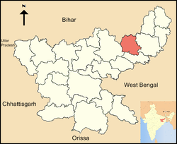
| Location of Deoghar district in Jharkhand | |
| Country | India |
| State | Jharkhand |
| Administrative division | Santhal Pargana division |
| Established | |
| Headquarters | Deoghar |
| Government | |
| • Lok Sabha constituencies | 1.Dumka (shared with Dumka district) 2.Godda (shared with Godda district) |
| • Assembly seats | 3 |
| Area | |
| • Total | 2,478.61 km2 (957.00 sq mi) |
| Population (2001) | |
| • Total | 11,65,390 |
| • Density | 470/km2 (1,200/sq mi) |
| • Urban | 25,64% |
| Demographics | |
| • Literacy | 50.53 per cent[1] |
| • Sex ratio | 911 |
| Website | Official website |
Deoghar district (Hindi: देवघर जिला) is one of the twenty-four districts of Jharkhand state in eastern India, and Deoghar town is the administrative headquarters of this district. This district is known for the Baidyanath Jyotirlinga shrine. This district is part of Santhal Pargana division.
History[]
The district was formed on 1 June 1986 by separating Deoghar sub-division of the erstwhile Santhal Parganas district.
Geography[]
Deogarh district is located in the western portion of Santhal paraganas. It is bounded by Bhagalpur district in north, Dumka in south and east and Giridhi in west. The district extends from 24 0 03’ and 23 0 38’ N latitude and 86 0 28’ and 87 0 04’ E longitude and comprises 2481 km2 area. It has population 11,65,390 persons (Census of India, 2001).
The district contains several clusters of rocky hills covered with forest, but series of long ridges with intervening depressions. Most of the rolling uplands are cultivated by highland crops. The average elevation of the district is 247 m above msl, However hill ranges like Phuljari (750 m), Teror (670 m) and Degaria (575 m) break the monotony of the landscape. The general slope of the district is from north west to south east. Geologically the district is mainly covered by chhotanagpur granite gneiss of Archean age with paches of alluvium, sandstone and shale of Gondawana formations. Important rivers flowing in the district are the Ajay, the Paltro etc. These rivers gather a large number of tributaries which form the land scape full of Tanrs and Dons.

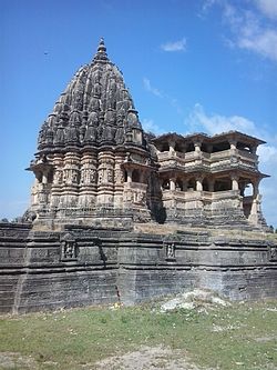
Naulakha Temple
Cities and villages[]
Taluk Name State Deoghar,Chitra, Charakmara, Palojori, Debipur, Madhupur, Sarwan, Sarath, Karon, Mohanpur, Rohni, babangaua,Ghorlash, Jasidih, Koridih, Raidih etc.
Climate[]
The district experience hot summer (March to May) heavy monsoon rains (June to September) and cool dry winters (October to February). Average annual rainfall is 1239 mm, mean summer maximum temperature is 43 0 C and mean winter minimum temperature is 8 0 C .
Economy[]
In 2006 the Indian government named Deogar one of the country's 250 most backward districts (out of a total of 640).[2] It is one of the 21 districts in Jharkhand currently receiving funds from the Backward Regions Grant Fund Programme (BRGF).[2]
Divisions[]
The district comprises seven blocks: Deoghar, Karon, Madhupur, Mohanpur, Palojori, Sarath and Sarwan.
There are 3 Vidhan Sabha constituencies in this district: Madhupur, Sarath and Deoghar. Madhupur and Deoghar are part of Godda Lok Sabha constituency, while Sarath is part of Dumka Lok Sabha constituency.
Demographics[]
According to the 2011 census Deoghar district has a population of 1,491,879,[3] roughly equal to the nation of Gabon[4] or the US state of Hawaii.[5] This gives it a ranking of 337th in India (out of a total of 640).[3] The district has a population density of 602 inhabitants per square kilometre (1,560 /sq mi) .[3] Its population growth rate over the decade 2001-2011 was 28.02 %.[3] Deoghar has a sex ratio of 921 females for every 1000 males,[3] and a literacy rate of 66.34 %.[3]
Culture[]
Tourist Attractions[]
B.Deoghar is a wonderful spot for the tourists. In Sawaan month (July, August) Peoples from all over India come to worship Lord Shiva. It is the peak time for tourists. Trikut Parvat, Nandan Pahar and Pagal Baba Aasram and lots of place for enjoyment. it also have a beautiful and mind blowing park known as jalsar park situated in the centre of the city.It is newly built and has many things to attract almost every section of people.So never miss a chance to visit the park whenever u are in deoghar. you can also visit the other tourist spots in town like trikut hills, tapovan hills.
Saawan Mela[]
The importance of Babadham increases during the month of Shrawan. During this period, lakhs of devotees throng the Baba Baidyanath temple. Most of them first visit Sultanganj, which is 105 km from Babadham.
In Sultanganj, the Ganges flows to the North. It is from this place that the devotees collect water in their kanwars and carry the holy Ganges water, with the kanwars on their shoulders. They walk 109 km up to Baba Baidyanath temple at Babadham reciting Bol Bam on the way.
On reaching Babadham, the kanwarias first take a dip in the Shivaganga to purify themselves, and then enter the Baba Baidyanath temple, where the Ganges water is offered to the Jyotirlingam.
This pilgrimage continues during the whole of Shravan for 30 days, during July–August. This is the longest religious fair in the world.
People from foreign lands also visit Babadham not only during Shrawan month but also during the rest of the year.
The sight on the way from Sultanganj to Babadham is of a 109 km long human chain of saffron clad pilgrims. It is estimated that within this period of one month around 50 to 55 lakhs pilgrims visit Babadham.
Besides the great pilgrimage of Shrawan, almost the whole year remains under fair with Shivaratri in March, Basant Panchami in January, Bhadra Purnima in September. Also here Rikhiya ashram famoue of world.
Temples and Holy places in and around Deoghar District[]
Ajgaibinath, Baiju Temple, Basukinath, Deva Sangha Math, Dolmanch, Harila Jori, Hathi Pahar or Mahadevatari, Jain Temple, Kathikund, Kundeshwari, Lila Temple, Mansarovar, Nandan Pahar, Naulakha Temple, Pagla Baba Ashram, Rikhia Ashram, Ram Krishna Mission Vidyapeeth, Satsang Nagar & Ashram, Shitala Temple, Shivaganga, Tapovan, Tarapeeth, Trikuta Parvata.
Other temples[]
- Taapovan- This temple is known to be existed from the time of Ramayana.It is said that The Lankan King Raavana praised Lord Shiva Enchanting him.Unfortunately, Hanuman did not let it happen.
- Naulakha Temple
- Baskinath Temple*Kinarinath Temple,sarwan
- Pathrol kali mandir
Education[]
Deoghar College in Deoghar town was founded in 1951. It is one of the constituent colleges of Sido Kanhu Murmu University at Dumka.
Rama Krishna Mission Vidyapith, Deoghar was founded in 1922 and is known for its quality education in secondary and higher secondary section. It is also known as Bangla Vidyapith among the locals. This school is run and managed by Rama Krishna Math, Belur, Kolkata. It has a residential Secondary and Senior Secondary School, a well equipped charitable medical unit with modern diagnostic facilities, a centre for academic coachings to school going children from the surrounding poor families, vocational training courses for local school drop-outs under the auspices of National Open School, and occasional activities of relief and rehabilitation work.
References[]
- ^ "District-specific Literates and Literacy Rates, 2001". Registrar General, India, Ministry of Home Affairs. http://www.educationforallinindia.com/page157.html. Retrieved 2010-10-10.
- ^ a b Ministry of Panchayati Raj (September 8, 2009). "A Note on the Backward Regions Grant Fund Programme". National Institute of Rural Development. http://www.nird.org.in/brgf/doc/brgf_BackgroundNote.pdf. Retrieved September 27, 2011.
- ^ a b c d e f Cite error: Invalid
<ref>tag; no text was provided for refs nameddistrictcensus - ^ US Directorate of Intelligence. "Country Comparison:Population". https://www.cia.gov/library/publications/the-world-factbook/rankorder/2119rank.html. Retrieved 2011-10-01. "Gabon 1,576,665"
- ^ "2010 Resident Population Data". U. S. Census Bureau. http://2010.census.gov/2010census/data/apportionment-pop-text.php. Retrieved 2011-09-30. "Hawaii 1,360,301"
External links[]

|
Jamui district, Bihar | Banka district, Bihar | 
| |
| Giridih district | Dumka district | |||
 Deoghar district | ||||
| Jamtara district |
| |||||||||||||||||
Template:Santhal Parganas Division Template:Santhal Pargana Division topics
| This page uses content from the English language Wikipedia. The original content was at Deoghar district. The list of authors can be seen in the page history. As with this Familypedia wiki, the content of Wikipedia is available under the Creative Commons License. |
