| ||||||||||||||
| Datia district दतिया जिला |
|
|---|---|
| — District of Madhya Pradesh — | |
 |
|
| Country | India |
| State | Madhya Pradesh |
| Administrative division | Gwalior division |
| Established | |
| Headquarters | Datia |
| Tehsils | Datia Seondha and Bhander |
| Government | |
| • Lok Sabha constituencies | Bhind lok sabha constituency |
| • Assembly seats | Datia Seondha and Bhander |
| Area | |
| • Total | 2,902 km2 (1,120 sq mi) |
| Population (2011) | |
| • Total | 786,754 |
| • Density | 270/km2 (700/sq mi) |
| • Urban | 181,976 |
| Demographics | |
| • Literacy | 72.63 per cent |
| • Sex ratio | 873 |
| Major highways | N75 |
| Website | Official website |
Datia District (Hindi: दतिया जिला) is in Gwalior Division in the Indian state of Madhya Pradesh. The town of Datia is the district headquarters.
History[]
It is an ancient town, mentioned in the Mahabharata as Daityavakra. Datia had formerly been a state in the bundelkhand region. The ruling family were Rajputs of the Bundela clan; they descended from a younger son of a former raja of Orchha. The state was administered as part of the Bundelkhand agency of Central India. It lay in the extreme north-west of Bundelkhand, near Gwalior, and was surrounded on all sides by other princely states of Central India, except on the east where it bordered upon the United Provinces.[1] It was second highest in the rank of all the Bundela states after Orchha, with a 15-gun salute, and its Maharajas bore the hereditary title of Second of the Princes of Bundelkhand. The land area of the state was 2130 mi² its population in 1901 was 173,759.[1]
Datia, together with the rest of the Bundelkhand agency, became part of the new state of Vindhya Pradesh in 1950. In 1956, Vindhya Pradesh state was merged with certain other areas to form the state of Madhya Pradesh within the Union of India.
Geography[]
In 2011, Datia had population of 786,754 of which male and female were 420,157 and 366,597 respectively The district has an area of 2,902 km², and a population 627,818 (2001 census). The population of Datia District increased by 26% from 1981 to 1991, and by 22% from 1991 to 2001. The district has 445 villages and 3 towns, Datia, Seondha, and Bhander. Each town is the headquarters of its tehsil.[2]
Datia is bounded by the Madhya Pradesh districts of Bhind to the north, Gwalior to the west, and Shivpuri to the south, and by Jhansi District of Uttar Pradesh state to the east. The district is part of Gwalior Division.[2]
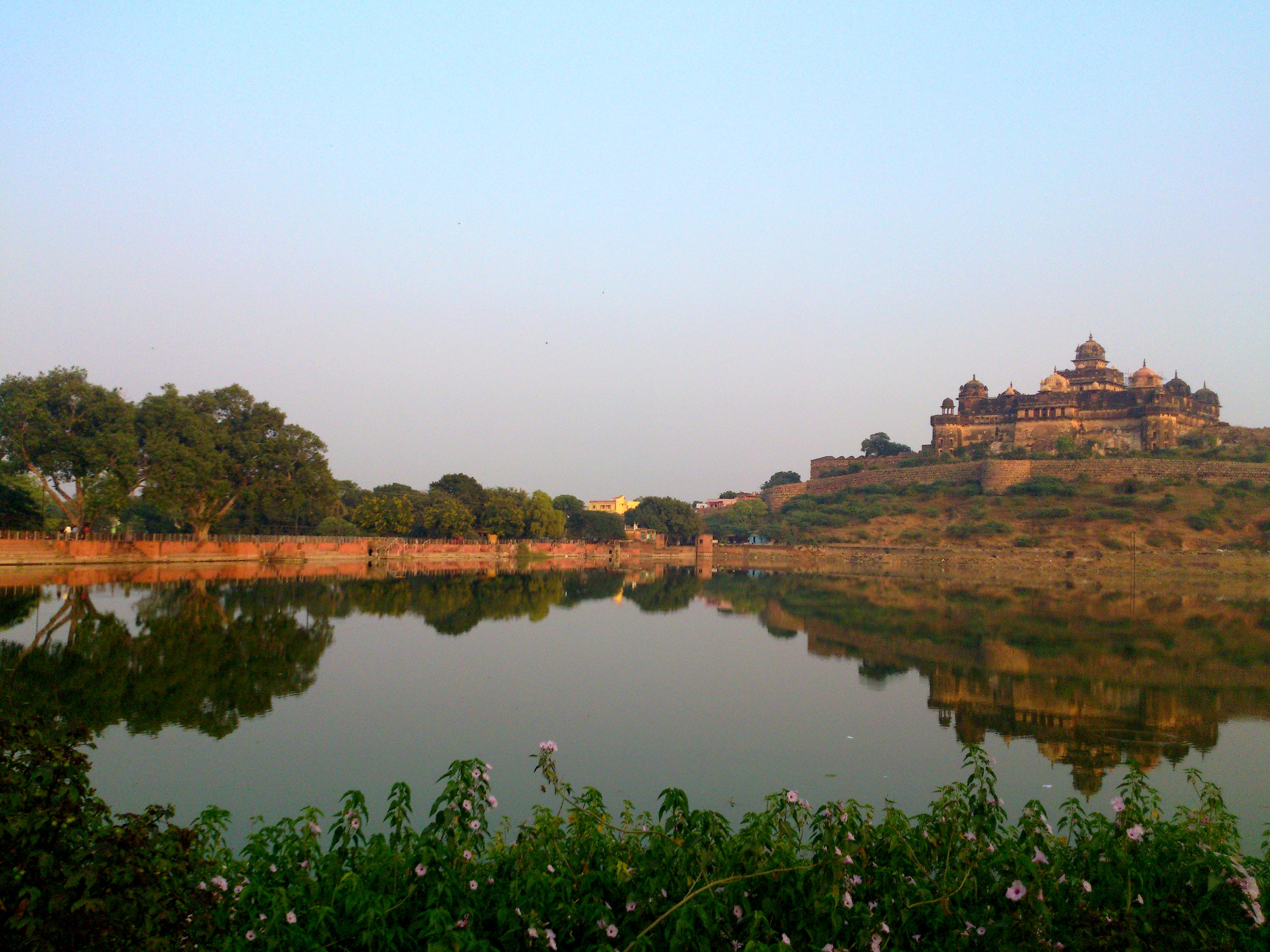
Veer Singh Palace
Tourist Places[]
Datia also has some famous temples. Peetambra Peeth is one such temple which attracts a lot of pilgrims. Purana Mahal also known as Datia Mahal is visible from the railway line between Gwalior to Jhansi and was built to welcome King Jahangir after his coronation. The King never actually visited fearing he would have to reward the King of Datia for his help in getting the Moghul throne. Some of other tourist spot are Ratangath Mata, Sonagiri-Temples, Shri Sidh Baba Mandir Kurthata, Beer Singh Deo Mahal,Unao-Balaji Sun Temple, Rajgarh Palace & Museum and Gujarra.
Drainage[]
The Datia district comes under the Gangetic drainage system and is drained by the Sindh, the Pahuj, the Mahuar and the Betwa. The former two, however form the drainage system of the main body of the district. The rivers are almost seasonal and have heavy run off only during the peak period of July and August. During the dry season most of the streams become dry and water is available only in a few channels of the main stream.
Demographics[]
Population[]


District Court at RamNagar
According to the 2011 census Datia District has a population of 786,754[3] roughly equal to the nation of Comoros[4] or the US state of South Dakota.[5] This gives it a ranking of 487th in India (out of a total of 640).[3] The district has a population density of 271 inhabitants per square kilometre (700 /sq mi) [3] with 76% living in rural regions and 24% living in urban areas. Its population growth rate over the decade 2001-2011 was 18.4%.[3] Datia has a sex ratio of 873 females for every 1000 males,[3] and a literacy rate of 72.63%.[3]
Languages[]
Main spoken languages are Khadiboli and Bundeli with Dravidian spoken by at least 200 000 members of the Bharia tribe and this is written in the Devanagari script.[6]
Religion[]
According to the census of 2011, 96% of residents follow Hinduism.
Culture[]
The main entertainment in Datia is music, dance and wrestling.
Economy[]
70% of the economy is based on agriculture.
Transport[]
The district is traversed by the West Central Railway line between Delhi and Bhopal.This is also connected by the top cities of India by national highway N75.
Education[]
According to the 2011 census, Datia has 750 primary schools, 500 middle schools and 250 high schools.
Sport[]
Traditional games like Kho kho, Gulli Danda, Pittu Garam/Sitoliya, Kabbadi, Wrestling, Cricket and Langdi are popular in Datia.
See also[]
- Datia State
References[]
- ^ a b
 One or more of the preceding sentences incorporates text from a publication now in the public domain: Chisholm, Hugh, ed. "Datia". Encyclopædia Britannica. 7. Cambridge University Press.
- ^ a b "Datia district". District Administration. http://datia.nic.in. Retrieved 2010-04-14.
- ^ a b c d e f "District Census 2011". Census2011.co.in. 2011. http://www.census2011.co.in/district.php. Retrieved 2011-09-30.
- ^ US Directorate of Intelligence. "Country Comparison:Population". https://www.cia.gov/library/publications/the-world-factbook/rankorder/2119rank.html. Retrieved 2011-10-01. "Comoros 794,683 July 2011 est."
- ^ "2010 Resident Population Data". U. S. Census Bureau. http://2010.census.gov/2010census/data/apportionment-pop-text.php. Retrieved 2011-09-30. "South Dakota 814,180"
- ^ M. Paul Lewis, ed (2009). "Bharia: A language of India". Ethnologue: Languages of the World (16th ed.). Dallas, Texas: SIL International. http://www.ethnologue.com/show_language.asp?code=bha. Retrieved 2011-09-28.
External links[]

|
Gwalior district | Bhind district |
| |
 Datia district | ||||
| Shivpuri district | Jhansi district, Uttar Pradesh |
| ||||||||||||||||||||
Template:Gwalior Division
| This page uses content from the English language Wikipedia. The original content was at Datia district. The list of authors can be seen in the page history. As with this Familypedia wiki, the content of Wikipedia is available under the Creative Commons License. |