| Main | Births etc |
|---|
| ||||||||||||||
| County Antrim Contae Aontroma Coontie Antrìm / Countie Antrim |
|||
|---|---|---|---|
|
|||
| Motto: Per angusta ad augusta (Latin) "Through Trial to Triumphs" |
|||
 |
|||
| Country | Northern Ireland | ||
| Region | Antrim | ||
| Province | Ulster | ||
| County town | Antrim | ||
| Area | |||
| • Total | 3,046 km2 (1,176 sq mi) | ||
| Area rank | 9th | ||
| Population (est. 2011) | 618,108 | ||
| • Rank | 2nd | ||
| Contae Aontroma is the Irish name; Coontie Antrìm,[1] Countie Antrim,[2] Coontie Anthrim[3] and Coonty Entrim[4] are Ulster-Scots names. | |||

County Antrim (named after the town of Antrim) is one of six counties that form Northern Ireland, situated in the north-east of the island of Ireland. Adjoined to the north-east shore of Lough Neagh, the county covers an area of 3,046 square kilometres (1,176 sq mi)[5] and has a population of about 618,000. It is also one of the thirty-two traditional counties of Ireland and is within the historic province of Ulster.
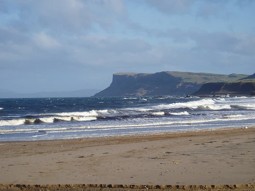
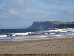
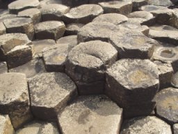
The Glens of Antrim offer isolated rugged landscapes, the Giant's Causeway is a unique landscape and a UNESCO World Heritage Site, Bushmills produces whiskey, and Portrush is a popular seaside resort and night-life area. The majority of the capital city of Northern Ireland, Belfast, is also in County Antrim, with the remainder being in County Down.
Geography[]

The famed Glens of Antrim at Glendun
Fair Head seen from Ballycastle

Columnar basalt at Giant's Causeway


Lisburn railway station

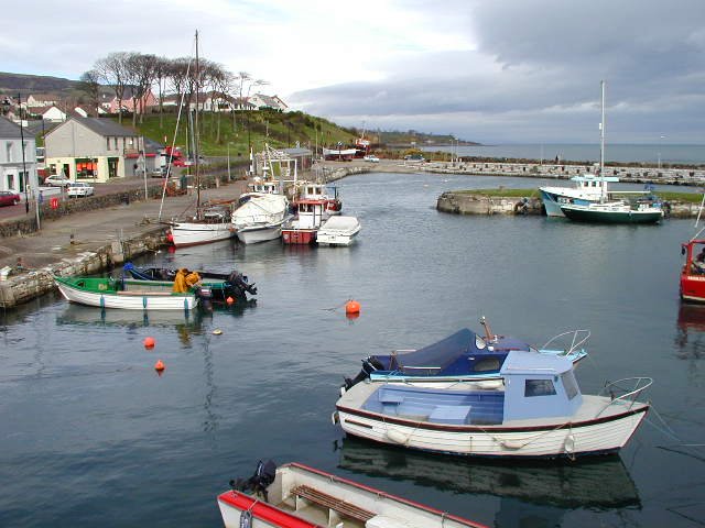
Larne Harbour
A large portion of Antrim is hilly, especially in the east, where the highest elevations are attained. The range runs north and south, and, following this direction the highest points are Knocklayd 514 m (1,690 ft), Slieveanorra 508 m (1,670 ft), Trostan 550 m (1,800 ft), Slemish 437 m (1,430 ft), Agnew's Hill 474 m (1,560 ft) and Divis 478 m (1,570 ft).[6] The inland slope is gradual, but on the northern shore the range terminates in abrupt and almost perpendicular declivities, and here, consequently, some of the finest coast scenery in the world is found, widely differing, with its unbroken lines of cliffs, from the indented coast-line of the west. The most remarkable cliffs are those formed of perpendicular basaltic columns, extending for many miles, and most strikingly displayed in Fair Head and the celebrated Giant's Causeway. From the eastern coast the hills rise instantly but less abruptly, and the indentations are wider and deeper. On both coasts there are several resort towns, including Portrush (with well-known golf links), Portballintrae and Ballycastle; on the east Cushendun, Cushendall and Waterfoot on Red Bay, Carnlough and Glenarm, Larne on the Sea of Moyle, and Whitehead on Belfast Lough. All are somewhat exposed to the easterly winds prevalent in spring. The only island of size is the L-shaped Rathlin Island, off Ballycastle, 11 km (6.8 mi) in total length by 2 km (1.2 mi) maximum breadth, 7 km (4.3 mi) from the coast, and of similar basaltic and limestone formation to that of the mainland. It is partially arable, and supports a small population. Islandmagee is in fact a peninsula separating Larne Lough from the North Channel.
The valleys of the Bann and Lagan, with the intervening shores of Lough Neagh, form the fertile lowlands. These two rivers, both rising in County Down, are the only ones of importance. The latter flows to Belfast Lough, the former drains Lough Neagh, which is fed by a number of smaller streams. The fisheries of the Bann and of Lough Neagh (especially for salmon and eels) are of value both commercially and to sportsmen, the small town of Toome, at the outflow of the river, being the centre. Immediately below this point lies Lough Beg, the "Small Lake", about 4.5 m (15 ft) lower than Lough Neagh.
Transport[]
County Antrim has a number of air, rail and sea links.
Air[]
Northern Ireland's main airport, Belfast International Airport, at Aldergrove is in County Antrim. Belfast International shares its runways with the Royal Air Force base RAF Aldergrove, which otherwise has its own facilities. It is the fifth largest regional air cargo centre in the UK. There are regular services to Great Britain, Europe and North America.
The region is also served by George Best Belfast City Airport, a mile east of Belfast city centre on the County Down side of the city, which was renamed in 2006 in honour of footballer George Best.
Rail[]
The main Translink Northern Ireland Railways routes are the major line between Belfast, Antrim, Ballymena, Coleraine and Londonderry, Belfast to Carrickfergus and Larne, the port for Stranraer in Scotland and Coleraine to Portrush.
Sea[]
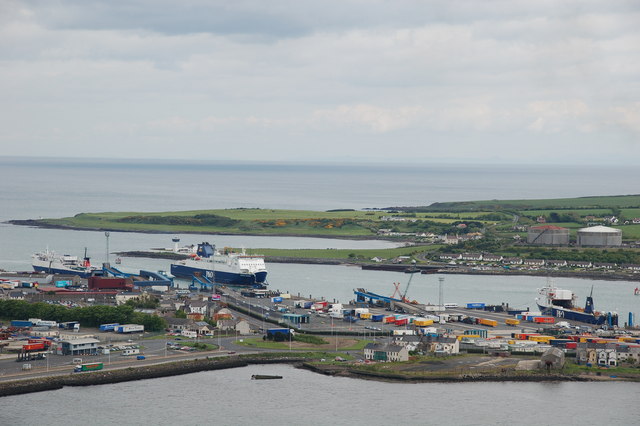
Two of Northern Ireland's main ports are in County Antrim, Larne and Belfast.
Ferries sail from Larne Harbour to destinations including Cairnryan and Troon in Scotland, and Fleetwood in England.
The Port of Belfast is Northern Ireland's principal maritime gateway, serving the Northern Ireland economy and increasingly that of the Republic of Ireland. It is a major centre of industry and commerce and has become established as the focus of logistics activity for Northern Ireland. Around two-thirds of Northern Ireland's seaborne trade, and a quarter of that for Ireland as a whole, is handled at the port which receives over 6,000 vessels each year.[7]
Population[]
The population of County Antrim was 615,384 according to recent census information, making it the most populous county in Northern Ireland.
Irish language[]
Statistics for 2009–2010 show 1,832 students attending the 12 Gaelscoileanna (Irish language primary schools) and 1 Gaelcholáiste (Irish language secondary school).[8]
Religion[]
The Presbyterian Church in Ireland is the largest religious denomination, followed by the Catholic Church and the Church of Ireland. County Antrim is one of two counties in Ireland in which the majority of people are Protestant, according to the 2001 census, the other being Down. The strong Presbyterian presence in the county is due largely to the county's historical links with lowland Scotland.
Administration[]
The traditional county town is Antrim. More recently, Ballymena was the seat of county government. The counties of Northern Ireland ceased to be administrative entities in 1973, with the reorganization of local government.
In Northern Ireland the county structure is no longer used in local government. Northern Ireland is split into districts. The majority of County Antrim residents are administered by the following nine councils:
- Antrim Borough Council
- Ballymena Borough Council
- Ballymoney Borough Council
- Belfast City Council
- Carrickfergus Borough Council
- Larne Borough Council
- Lisburn City Council
- Moyle District Council
- Newtownabbey Borough Council
Small portions of the county are administered by councils that are based in neighbouring counties, notably the village of Aghagallon in the Craigavon Borough and the town of Portrush in the Coleraine Borough.
The county contains all of five parliamentary constituencies:
- Belfast North
- Belfast West
- East Antrim
- North Antrim
- South Antrim
Parts of the following constituencies are also in County Antrim:
- Belfast South
- East Londonderry
- Lagan Valley
- Upper Bann
Settlements[]


Ballycastle

Carnlough
Large towns[]
(population of 18,000 or more and under 75,000 at 2001 Census)[9]
- Antrim
- Ballymena
- Carrickfergus
- Larne
- Lisburn (has city status)
- Newtownabbey
Medium towns[]
(population of 10,000 or more and under 18,000 at 2001 Census)[9]
- none
Small towns[]
(population of 4,500 or more and under 10,000 at 2001 Census)[9]
- Ballycastle
- Ballyclare
- Ballymoney
- Greenisland
- Jordanstown
- Portrush
- Randalstown
Intermediate settlements[]
(population of 2,250 or more and under 4,500 at 2001 Census)[9]
- Ahoghill
- Broughshane
- Crumlin
- Cullybackey
- Whitehead
Villages[]
(population of 1,000 or more and under 2,250 at 2001 Census)[9]
- Bushmills
- Carnlough
- Cloughmills
- Cogry & Kilbride
- Cushendall
- Doagh
- Dunloy
- Glenavy
- Kells
- Portglenone
- Templepatrick
Small villages or hamlets[]
(population of less than 1,000 at 2001 Census)[9]
- Aghagallon
- Aghalee
- Aldergrove
- Armoy
- Ballintoy
- Ballycarry
- Ballyeaston
- Ballygalley
- Ballynure
- Boneybefore
- Carnalbanagh
- Cargan
- Cushendun
- Dervock
- Glenarm
- Glynn
- Loughguile
- Moss-Side
- Newtown Crommelin
- Parkgate
- Portballintrae
- Rasharkin
- Stranocum
- Toome
Subdivisions[]
Baronies
| * Antrim Lower | * Cary | * Kilconway |
| * Antrim Upper | * Dunluce Lower | * Massereene Lower |
| * Belfast Lower | * Dunluce Upper | * Massereene Upper |
| * Belfast Upper | * Glenarm Lower | * Toome Lower |
| * Carrickfergus | * Glenarm Upper | * Toome Upper |
Parishes
Townlands
History[]


Royal Avenue, Belfast. Photochrom print circa 1890–1900.
At what date the county of Antrim was formed is not known, but it appears that a certain district bore this name before the reign of Edward II (early 14th century), and when the shiring of Ulster was undertaken by Sir John Perrot in the 16th century, Antrim and Down were already recognised divisions, in contradistinction to the remainder of the province. The earliest known inhabitants were Mesolithic hunter-gatherers of pre-Celtic origin,[10] but the names of the townlands or subdivisions, supposed to have been made in the 13th century, are all of Gaelic derivation.
In ancient times, Antrim was inhabited by a Celtic people called the Darini.[11] In the early Middle Ages, southern County Antrim was part of the Kingdom of Ulidia, ruled by the Dál Fiatach clans Keenan and MacDonlevy/McDunlavey; the north was part of Dál Riada, which stretched into what is now western Scotland over the Irish Sea. Dál Riada was ruled by the O'Lynch clan, who were vassals of the Ulidians. Besides the Ulidians and Dál Riada, there were the Dál nAraide of lower County Antrim, and the Cruthin, who were pre-Gaelic Celts and probably related to the Picts of Britain.[12] Between the 8th and 11th centuries Antrim was exposed to the inroads of the Vikings.
In the late 12th century Antrim became part of the Earldom of Ulster, conquered by Anglo-Norman invaders. A revival of Gaelic power followed the campaign of Edward Bruce in 1315, leaving Carrickfergus as the only significant English stronghold. In the late Middle Ages, Antrim was divided into three parts: northern Clandeboye, the Glynnes and the Route. The Cambro-Norman MacQuillans were powerful in the Route. A branch of the O'Neills of Tyrone migrated to Clandeboye in the 14th century, and ruled it for a time. Their family was called O'Neill Clannaboy. A Gallowglass sept, the MacDonnells, became the most powerful in the Glynnes in the 15th century.
During the Tudor era (16th century) numerous adventurers from Britain attempted to colonise the region; many Scots settled in Antrim around this time.[13] In 1588 the Antrim coast was the scene of one of the 24 wrecks of the Spanish Armada in Ireland. The Spanish vessel La Girona was wrecked off Lacana Point, Giant's Causeway in 1588 with the loss of nearly 1,300 lives.[14]
Antrim is divided into sixteen baronies. Lower Antrim, part of Lower Clandeboye, was settled by the sept O'Flynn/O'Lynn. Upper Antrim, part of Lower Clandeboye, was the home of the O'Keevans. Belfast was part of Lower Clandeboye and was held by the O'Neill-Clannaboys. Lower Belfast, Upper Belfast, and Carrickfergus were also part of Lower Clandeboye. Cary was part of the Glynnes; ruled originally by the O'Quinn sept, the MacDonnell galloglasses from Scotland took power here in the late Middle Ages and some of the O'Haras also migrated from Connaught. Upper and Lower Dunluce were part of the Route, and were ruled by the MacQuillans. Upper and Lower Glenarm was ruled by the O'Flynn/O'Lynn sept, considered part of the Glynns. In addition to that sept and that of O'Quinn, both of which were native, the Scottish Gallowglass septs of MacKeown, MacAlister, and MacGee, are found there. Kilconway was originally O'Flynn/O'Lynn territory, but was held by the MacQuillans as part of the Route, and later by the gallowglass sept of MacNeill. Lower Massereene was part of Lower Clandeboye and was ruled by the O'Flynns and the O'Heircs. Upper Massereene was part of Lower Clandeboye, ruled by the O'Heircs. Upper and Lower Toome, part of the Route, were O'Flynn/O'Lynn territory. Misc was first ruled by the MacQuillans. Later, the Scottish Gallowglass MacDonnells and MacAlisters invaded. The MacDonnells were a branch of the Scottish Clan MacDonald; the MacAlisters traced their origin back to the Irish Colla Uais, eldest of the Three Collas.
Islandmagee had, besides antiquarian remains, a notoriety as a home of witchcraft, and during the Irish Rebellion of 1641 was the scene of an act of reprisal (for the massacre of Protestants) against the Catholic population by the Scottish Covenanter soldiery of Carrickfergus.
Historic monuments[]


Dunluce Castle.


Carrickferrgus Castle (1177)
The antiquities of the county consist of cairns, mounts or forts, remains of ecclesiastical and military structures, and round towers.
There are three round towers: one at Antrim, one at Armoy, and one on Ram's Island in Lough Neagh, only that at Antrim being perfect. There are some remains of the ecclesiastic establishments at Bonamargy, where the earls of Antrim are buried, Kells, Glenarm, Glynn, Muckamore and Whiteabbey.
The castle at Carrickfergus, dating from the Norman invasion of Ireland, is one of the best preserved medieval structures in Ireland. There are, however, remains of other ancient castles, as Olderfleet, Cam's, Shane's, Glenarm, Garron Tower, Red Bay, and Dunluce Castle, notable for its dramatic location on a rocky outcrop.
The principal cairns are: one on Colin mountain, near Lisburn; one on Slieve True, near Carrickfergus; and two on Colinward. The cromlechs most worthy of notice are: one near Cairngrainey, to the north-east of the old road from Belfast to Templepatrick; the large cromlech at Mount Druid, near Ballintoy; and one at the northern extremity of Islandmagee. The mounts, forts and entrenchments are very numerous.
The natural rock formations of Giant's Causeway on the Antrim coast are now designated a UNESCO World Heritage Site.
Saint Patrick[]
Slemish, about eight miles (13 km) east of Ballymena, is notable as being the scene of St Patrick's early life. According to tradition Saint Patrick was a slave for seven years, near the hill of Slemish, until he escaped back to Great Britain.
Linen[]
Linen manufacturing was previously an important industry in the County. At the time Ireland produced a large amount of flax. Cotton-spinning by jennies was first introduced to Belfast by industrialists Robert Joy and Thomas M'Cabe in 1777; and twenty-three years later it was estimated that more than 27,000 people were employed in the industry within ten miles (16 km) of Belfast. Women were employed in the working of patterns on muslin.
Notable residents[]
- James Adair (1709–1783), born in County Antrim, explorer, trader, and historian[15]
- Charles Clinton Beatty (1715?–1772), born in County Antrim, noted clergyman in the New Jersey area[15]
- John Bodkin Adams (1899–1983), general practitioner born in Randalstown and suspected of killing 163 patients while practising in Eastbourne, England.[16]
- William Arthur (1797–1875), born in Ballymena, noted antiquitarian and Baptist clergyman in the United States.[15]
- Joey Dunlop, OBE (1952–2000), from Ballymoney, five time World Motorcycle Champion.
- Sir John Jamison (1776–1844), physician and naval surgeon from Carrickfergus who became an important pioneering landowner and constitutional reformer in New South Wales, Australia.
- George Macartney, 1st Earl Macartney (1737–1806), from Ballymoney, first British Ambassador to China in 1772.
- Eva McGown (1883–1972), chorister, pioneer, and hostess in Alaska.
- John O'Kane Murray (1847–1885), born in Antrim, physician and noted author.[15]
- James Nesbitt (1965—), from Broughshane (though he lived near Coleraine for most of his teenage and adult life), notable actor.
- Liam Neeson (1952—), from Ballymena, notable actor.
- Tony McCoy (1974–), from Moneyglass, notable jockey.
- Hugh Boyle (1897–1986), from Dunloy, Catholic Bishop of Port Elizabeth, 1951-1954, Bishop of Johannesburg, 1954-1976.
Flora and fauna[]
Records of the seaweeds of County Antrim were brought together and published in 1907 by J. Adams[17] who notes that the list contains 211 species. Batter's list, of 1902,[18] contained 747 species in his catalogue of British marine algae.
Of the freshwater algae there are 10 taxa in the Charophyta (Charales) recorded from Co. Antrim: Chara aspera Deth. ex Willd. var. aspera; Chara globularis Thuill. var. globularis; Chara globularis var. virgata (Kütz.) R.D.;Chara vulgaris L. var. vulgaris; Chara vulgaris var. contraria (A. Braun ex Kütz.) J.A.Moore; Chara vulgaris var. longibracteata (Kütz.) J.Groves & Bullock-Webster; Chara vulgaris var. papillata Wallr. ex A. Braun; Nitella flexilis (L.) Ag. var. flexilis; Nitella translucens (Pers.) C.A. Ag. and Tolypella nidifica (O.Mull.) Leonh. var. glomerata (Desv.) R.D. Wood.[19]
Sport[]
See also[]
- Abbeys and priories in Northern Ireland (County Antrim)
- List of townlands in County Antrim
- List of civil parishes of County Antrim
- Lord Lieutenant of Antrim
- High Sheriff of Antrim
References[]
- ^ Bonamargy Friary Guide Department of the Environment.
- ^ North-South Ministerial Council: 2004 Annual Report in Ulster Scots
- ^ 2008 annual report in Ulster-Scots Tourism Ireland.
- ^ The Ulster-Scot, June 2011 Charlie 'Tha Poocher' Rennals.
- ^ [1] County Antrim
- ^ "Mountain Views". Simon Stewart. http://mountainviews.ie/mv/index.php?ids=summit_view&mtnindex=361. Retrieved 30 August 2010.
- ^ Port of Belfast
- ^ Statistics from the national Gaelscoil management body, accessed at http://www.gaelscoileanna.ie/assets/Oid-Tr%C3%AD-Mhe%C3%A1n-na-Gaeilge-in-%C3%89irinn-sa-Ghalltacht-09_101.doc, January 2012
- ^ a b c d e f "Statistical classification of settlements". NI Neighbourhood Information Service. http://www.ninis.nisra.gov.uk/mapxtreme_towns/statistical%20classification.htm. Retrieved 23 February 2009.
- ^ Waddell, John (1998). The Prehistoric Archaeology of Ireland. Galway: Galway University Press Limited. pp. 11–24.
- ^ O'Rahilly, Thomas F. (1946). Early Irish History and Mythology. Dublin: Dublin Institute for Advanced Studies. p. 7.
- ^ O'Rahilly, Thomas F. (1946). Early Irish History and Mythology. Dublin: Dublin Institute for Advanced Studies. pp. 341–352.
- ^ Benn, George (1877). A History of the Town of Belfast. Belfast: Marcus Ward & Company. pp. 21 ff..; Encyclopædia Britannica (14th edition), Antrim.
- ^ "La Girona" (PDF). # Annual Report of the Advisory Committee on Historic Wrecks, 2005. Advisory Committee on Historic Wreck Sites. pp. 35. http://www.english-heritage.org.uk/upload/pdf/ACHWS_annual_report_2005.pdf. Retrieved 1 November 2008.
- ^ a b c d Who Was Who in America, Historical Volume, 1607–1896. Chicago: Marquis Who's Who. 1967. Cite error: Invalid
<ref>tag; name "Marquis 1607-1896" defined multiple times with different content - ^ Cullen, Pamela V., "A Stranger in Blood: The Case Files on Dr John Bodkin Adams", London, Elliott & Thompson, 2006, ISBN 1-904027-19-9
- ^ Adams, J.1907. The Seaweeds of the Antrim Coast. Scient. Pap. Ulster Fish. Biol. Ass. Vol.1: 29 – 37
- ^ Batters, E.A.L. 1902. A catalogue of the British marine algae being a list of all the species of seaweed known to occur on the shores of the British Islands, with the localities where they are found. J. Bot., Lond. 40 (suppl.): (2) + 107.
- ^ Hackney, P. ed. Stewart & Corry's Flora of the North-east of Ireland. Third edition Institute of Irish Studies and The Queen's University of Belfast. ISBN 0 85389 446 9
 This article incorporates text from a publication now in the public domain: Chisholm, Hugh, ed. Encyclopædia Britannica. Cambridge University Press.
External links[]
| Wikivoyage has a travel guide for County Antrim. |
- County Antrim at the Open Directory Project
- County Antrim in 1900
- Castle FM – County Antrim Radio Station
- The Northern Ireland Guide: For information and reviews for locals and tourists alike
- Local Antrim Guide
| |||||||||||||||||||||||
| ||||||||
| ||||||||||||||||||||||||

Template:Geology of Northern Ireland
| This page uses content from the English language Wikipedia. The original content was at County Antrim. The list of authors can be seen in the page history. As with this Familypedia wiki, the content of Wikipedia is available under the Creative Commons License. |