| Main | Births etc |
|---|
| Colonial Heights | |||
|---|---|---|---|
| — City — | |||
|
|||

Colonial Heights |
|||
| Coordinates: Coordinates: | |||
| Country | United States | ||
| State | Virginia | ||
| Incorporated (town) | 1926 | ||
| Incorporated (city) | 1948 | ||
| Government | |||
| • Mayor | C. Scott Davis | ||
| Area | |||
| • City | 7.8 sq mi (20 km2) | ||
| • Land | 7.5 sq mi (19 km2) | ||
| • Water | 0.3 sq mi (1 km2) 3.7% | ||
| Elevation | 95 ft (29 m) | ||
| Population (2010) | |||
| • City | 17,411 | ||
| • Density | 2,321/sq mi (896/km2) | ||
| • Metro | 1,126,262 | ||
| Time zone | EST (UTC-5) | ||
| • Summer (DST) | EDT (UTC-4) | ||
| Area code(s) | 804 | ||
| FIPS code | 51-18448[1] | ||
| GNIS feature ID | 1496852[2] | ||
| Website | colonialheightsva.gov | ||
Colonial Heights is an independent city in Virginia, United States. As of the 2010 census, the population was 17,411.[3] The Bureau of Economic Analysis combines the City of Colonial Heights (along with the City of Petersburg) with Dinwiddie County for statistical purposes.
Colonial Heights is located in the Tri-Cities area of the Richmond Metropolitan Statistical Area (MSA).
History
Like much of eastern Virginia, the site of Colonial Heights was located within the Algonquian-speaking confederation known as Tenakomakah, ruled by Chief Powhatan, when the English colonists arrived at Jamestown on May 14, 1607. Captain John Smith's early map of Virginia testifies that the present area of Colonial Heights included the principal town of the Appamattuck subtribe, led by their weroance, Coquonasum, and his sister, Oppussoquionuske. In the aftermath of the Indian attacks of 1622 and 1644, the Appamattuck became tributary to England and relocated to nearby Ettrick, and its opposite bank, near Fort Henry (within modern-day Petersburg, Virginia).
The area including present-day Colonial Heights was made a part of "Henrico Cittie", one of 4 huge "incorporations" formed in the Virginia Colony in 1619 by the London Company. English colonists first settled in the Colonial Heights area in 1620. A small group sailed up the Appomattox River looking for clear land, and finally settled in an area where Swift Creek runs into the Appomattox River, which they named Conjurer's Neck. This confluence was formerly the residence a Native American healer (known as a "conjurer") who was thought to have cast spells over the waters.
Shortly thereafter, Charles Magnor registered the first land patent in the area for 650 acres (2.63 km2), which he later developed into a plantation before selling it in 1634. That same year, by order of King Charles I of England, the Virginia Colony was divided into the 8 original shires of Virginia by the House of Burgesses, one of which was Henrico County, which included the future land of Colonial Heights.
In 1635, the English had a small town called Appamattucks near the "Old Towne" Creek,[4] thought to be located near the intersection of Temple Avenue and Dimmock Parkway.[5] Also in that year, Captain Henry Fleet and Francis Poythress built a small fort nearby, on "Fleet's Hill" just west of the current city, now occupied by the campus of Virginia State University.
During the period from 1677 to 1685, one of the area's historic landmarks was constructed with the building of the Old Brick House. Richard Kennon came to Virginia prior to 1670, and became a merchant of Bermuda Hundred. He represented Henrico County in the House of Burgesses. His son, Richard Kennon, Jr., was also a member of the House of Burgesses and married the daughter of Col. Robert Bolling, the emigrant, and his second wife, the former Anne Stith. Richard's sister, Mary Kennon, was married to Major John Fairfax Bolling, half-brother of Richard's wife. Major Bolling was the son of Col. Robert Bolling and his first wife Jane Rolfe, who was granddaughter of the early colonist John Rolfe and his Native American wife, Pocahontas. The Bollings lived at Cobb's, a plantation in eastern Chesterfield near Point-of-Rocks.
The manor house built by Richard Kennon (later known as the "Brick House") is now thought to be the oldest permanent structure in Colonial Heights. One wall of the house survived a disastrous fire in 1879, and the rest was rebuilt. [1]
In 1749, an area south of the James River was divided from Henrico County by the House of Burgesses, and named Chesterfield County. The area which became Colonial Heights was to remain in Chesterfield County for almost 200 more years, until 1948.
The name "Colonial Heights" results from an incident during the American Revolutionary War. In May 1781, the French troops of General Marquis de Lafayette, known as the Coloniels, advanced south from Richmond and deployed artillery on the heights overlooking Petersburg from across the Appomattox River. The area thereafter came to be known as "Colonial Heights", and the name was given to a subdivision of the Oak Hill tract in 1906.
A historic site, Oak Hill, on Carroll Avenue, also called Archer's, Hector's, or Dunn's Hill, consisted of two one-story weatherboarded structures connected by a deep inside porch that extends from an uncovered section toward the street. From the lawn of this house, in May 1781, General Lafayette — with cannon behind a boxwood hedge that still fringes the hill — shelled Petersburg, then occupied by British troops under Major-General William Phillips (who died of typhoid during this bombardment).
The area also became involved in operations during the American Civil War. General Robert E. Lee made his headquarters at Violet Bank from June through September during the Siege of Petersburg in 1864.
In 1926, Colonial Heights became an incorporated town in Chesterfield County. It was incorporated as a city in 1948; under Virginia law, it separated from Chesterfield County and became an independent city. Its current charter was granted in 1960. From 1960 to 1970, Colonial Heights experienced a period of rapid growth as the population jumped from 9,587 to 15,097.
In the mid-1980s, completion of the State Route 144 (Temple Avenue Connector) and a new bridge across the Appomattox River provided access to State Route 36 near Fort Lee. The new road and bridge effectively opened a large previously isolated tract of land along the southeastern edge of the city for commercial development. There, the regional Southpark Mall and many other retail businesses and offices were built.
On August 6, 1993, an F4 tornado (max. wind speeds 207-260 mph) passed through Colonial Heights. It caused extensive damage to the Southpark Mall and collapsed the roof of an old Wal Mart (now Sam's Club) store. It also did extensive damage in Petersburg and Hopewell. In the Tri-Cities area, the tornado killed 4 people (3 in Wal-Mart & 1 in Prince George), injured 246, and caused an estimated $50 million in property damage.
On April 28, 2008, an EF1 tornado (max. wind speeds 86-110 mph) produced a near two mile (3 km) long, though discontinuous, path through Colonial Heights. The tornado first touched down near the Colonial Heights Middle School football field, damaging the field clubhouse roof, then causing roof damage and spill onto I-95 from Medallion Pool business. The tornado then jumped I-95 and touched down again in the Dimmock Square Shopping Center. Several cars were flipped and piled in the parking lot of a strip mall (which had extensive roof damage) that is less than a tenth of a mile from the site of the old Wal Mart which was destroyed by an F4 tornado on August 6, 1993. The tornado then continued across Temple Avenue, causing tree and roof damage in the neighborhood near Fine Drive and Puddledock Road (in Prince George County) before lifting for good. The tornado injured 21 and caused an estimated $10 million in property damage.
Historical attractions
Two area attractions with historic roots are Violet Bank and Swift Creek Mill. There are also several parks in the area, including Fort Clifton Park and White Bank Park.
Colonial Heights is also home of the largest Arby's restaurant in the world.
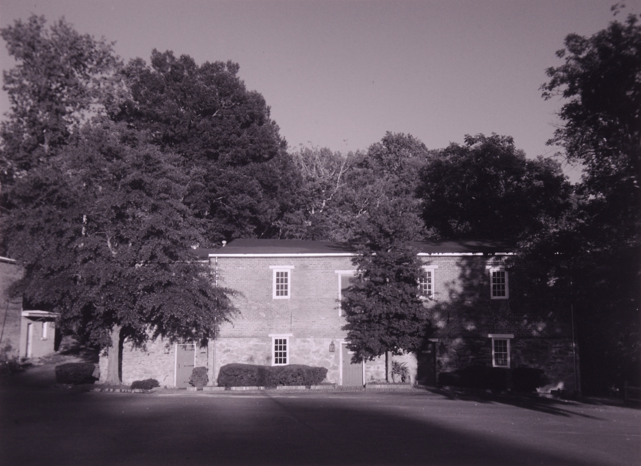
Violet Bank Museum
|
Violet Bank | |
|
{{{designated_other1_name}}} | |
 | |
|
Violet Bank Museum | |
|
| |
| Location: | Royal Oak Ave., Colonial Heights, Virginia |
|---|---|
| Coordinates: | |
| Area: | less than one acre |
| Built: | 1815 |
| Architectural style: | Federal |
| Governing body: | Local |
| NRHP Reference#: | 74002234[6] |
| {{{DESIGNATED_OTHER1_ABBR}}} #: | 106-0003 |
| Significant dates | |
| Added to NRHP: | July 30, 1974 |
| Designated {{{DESIGNATED_OTHER1_ABBR}}}: | April 16, 1974[7] |
The development of the estate began in 1777, when Thomas Shore purchased 144 acres atop “Archers Hill” from the heirs of John Martin. The first house was completed in 1778. Violet Bank originally fit an almost canonized two-over-two centre hall plan typical of late colonial Tidewater Virginia. This house served as General Gilbert du Motier, marquis de Lafayette’s Headquarters at the beginning of the 1781 summer campaign in the South, which eventually ended in Cornwallis’ capitulation at the Siege of Yorktown.
There were two American Revolutionary War actions fought on the hillside. The first was in March 1781 under von Steuben and his Virginia Militia; the second in April 1781, under Lafayette. Both of these were actions against British Major General William Phillips, who mentioned the property in a dispatch: "We assaulted the enemy’s work across the river and attempted to gain the high ground adjacent to Thomas Shore’s house, but were repulsed with heavy losses." The British casualties were approx. 200.
Phillips' objectives were to capture the crucial river crossing on the Appomattox, and gain control over the Turnpike. Not only was Petersburg the only major thoroughfare through Southside Central Virginia that would facilitate troop movement, it was also the primary access road for Chesterfield Courthouse, a primary supply depot and one of three training grounds for the Continental Line in Virginia.
Phillips became ill, and subsequently died, buried in an unmarked grave, lest the rebels desecrate his resting place. He is the second highest ranking British officer buried outside Great Britain. Cornwallis then acceded to command. Lacking sufficient strength to overwhelm Lafayette on the Heights, Cornwallis decided to abandon Virginia and campaign farther south.
Violet Bank would once again play host to Lafayette in 1824, when he visited the country for the last time as an official guest of the United States. During the interim between General Lafayette's two visits, Violet Bank’s appearance was completely altered. It was described in the Mutual Assurance of Society of Virginia papers of 1796 as a "two-story clapboard structure w/addition in which there was a cellar floored in stone w/kitchen". Violet Bank originally bore a strong resemblance to the still extant Weston Manor in Hopewell, Virginia. Benjamin Latrobe intended on lodging at Violet Bank, “but he (Thomas Shore) is at present building, and occupies his offices only, which, in Virginia, follows a plantation house as a litter of pigs to their mother.”
The house caught fire in 1810, supposedly on a Sunday whilst the family was away at church. Thomas Shore would occupy the house for 22 years until his death in 1800, leaving behind a much younger wife and three daughters, the oldest of whom was four at the time. The “Widder Jane Grey” would remarry in 1804, Henry Haxall of Haxall Mills. They and the three girls were the residents when the house burned, the cellar kitchen being a likely culprit. The chimney stacks and foundation survived the fire, which was somewhat unusual since the lime mortar used during the period did not generally withstand the intense heat that a house fire would generate and would be “cooked out”.
From 1810 to 1815 the house was rebuilt; the front foundation was altered, a radically different super-structure was built atop the first Violet Banks foundation, and an entirely new main house was constructed. Enter Benjamin Latrobe again, or at least his designs. Latrobe in all probability made the acquaintance of Jane Grey Shore Haxall when he visited Petersburg in 1796 and went to the horse races with Thomas Shore on April 21 of that year according to his Journal. He dined with Thomas’ brother Dr. John Shore on the 22nd. Latrobe’s notation for the 23rd stated that he had gotten into Shore's house and was “much more comfortable than in the buzz of betting at the track.” Whether he meant Dr. Johns residence or Thomas’ is unclear.
The consensus of most architectural historians is that Violet Bank was designed by a pupil of Latrobe’s, although there is nothing that suggests that Robert Mills might have had a hand in its planning. The possibility also exists that Violet Bank is, like Point of Honor in Lynchburg, the product of a country builder who was familiar with Latrobe’s work in Richmond, and used that as a base from which to start, through the house could be right out of a Latrobe sketchbook with its combination of octagonal bays, recessed portico and Adam-style ceiling moulding.
There are quite a number of shared characteristics between Violet Bank and a known Latrobe house, that of Michael Hancock built Ca. 1808-09. Henry Haxall would, at least, have been familiar with this fashionable house on the corner of 5th & Main in Richmond, as well as the architectural trend in Richmond which this house embodied. Jane Grey, having met the man, was likely to have passing knowledge of Latrobe’s architectural ideas. A quick perusal of the inventory for Henry Haxalls’ will probate clearly indicates a man of taste concerned with fashion. Mr. & Mrs. Haxall were certainly wealthy enough to have hired Latrobe, and if they did not consult with him on rebuilding project, they must probably asked him to suggest an architect, he would have named one of his own pupils.
Whoever the architect was, his refuse of the existing foundation and chimney stacks make the architectural solution all more unique. Normally an architect starts with a blank page, however, in this case, the architect was forced to deal with fixed points & proportions. The second floor fireboxes were bricked up, the second floor was eliminated, which enabled the ceilings to be raised. All masonry was stuccoed & scored to resemble ashlar and to hide the difference in brickwork that the modifications necessitated.
The tripartite foundation plan lent itself naturally to a very strict Vitruvian construct. The peculiar ring to be founded on third the distance up each Portico column, unique to Virginia architecture, form the keynote that coalesces the structure into a harmonious whole & unlocks the architectural formula.
Henry Haxall died in 1834, the same year as his eldest step-daughter married Dr. John Gilliam. Thomas Shore's middle daughter Marie Louisa married Dr. William Shippen II of Philadelphia. The youngest, Jane Grey, died at the age of 15 without issue. The estate passed to the Gilliams’ upon the death of Jane Haxall, eleven years after her husband, in 1834. Violet Bank would remain in the Gilliam Family's hands until 1873. At the time of its occupation by the Headquarters of the Army of Northern Virginia, the title to Violet Bank was held in deed of trust by Thomas Gilliam, Thomas Shore's grandson.
Part of the Main house also served as a hospital during the siege. The war largely impoverished the Gilliam family, and the house was sold in 1873 to a cousin, Mrs. Evelyn Gasquet Marshall of New York. She would occupy the house until her death in 1885, when the property was acquired by Capt. Abel N. Haskins. His heirs, in turn, sold houses and remaining 68 acres to the Greater Petersburg Realty Corporation in 1905. Operating Violet Bank as a dairy farm, the new owners knocked out walls on the first floor of the main house in order to utilize the structure as a cattle barn. Greater Petersburg Reality Corp. CEO Bellamy decided in the late 1914 to subdivide the farm and develop it for housing, and work began in 1915. The first thing Bellamy did in breaking up the property was tear down the main house, leaving the extant portion remaining.
The much reduced Violet Bank would be one of the first houses sold in River view sub-division. It was purchased in 1919 by Mrs. Alice Pierrepont who resided there until 1948, at which time she sold it to American Legion Post 284. The City of Colonial Heights acquired the house in 1959, first for the Chamber of Commerce, then as Colonial Heights first public library. It was listed on the National Register of Historic Places in 1974.[6] Now a part of the Recreation & Parks department, Violet Bank began its current incarnation as an active Historic House Museum in 1988.
Violet Bank Museum is a superb document of Federal design and American Interior Decorative Arts. It is on the National Register of Historic Places and a Virginia Historic Landmark.
Swift Creek Mill

Swift Creek Mill
Records indicate that Swift Creek Mill was in existence as early as 1663. It is believed to be the oldest grist mill in the United States.
Henry Randolph I, who was born in Little Houghton, Northamptonshire, England in 1623, moved to Virginia about 1640. In 1655 he acquired title to a large tract of land in Bermuda Hundred on Swift Creek, where he erected the present mill. "Mr. Randolph's Mill" is mentioned in 1663 in "Cavaliers and Pioneers" (index to Virginia - 1620 to 1666).
An heir of Henry Randolph I, William Bland Randolph, deeded the mill site to William Rowlett on February 20, 1805, and it became known as Rowlett's Mill. In 1852, the Rowlett heirs conveyed the mill to the Swift Creek Manufacturing Company.
On May 9 and 10, 1864, the Battle of Swift Creek was fought around the mill when Union General Benjamin F. Butler's Army of the James attempted to cross Swift Creek.
Following the American Civil War the property was known as Schmidt's Distillery, which made corn whiskey. Following this, the property changed hands several times and was operated as a grist mill. In 1929, the mill became known as Swift Creek Mill. The grist mill continued in operation until about 1956.
The Swift Creek Mill was purchased in August 1965 by Wamer J. Callahan Jr. and Dr. Louis Rubin, both native Virginians, with the idea of converting the 305 year old building into a dinner theater. The plan was to convert the three existing floors into two dining rooms connected by a new stairwell and to be known as Swift Creek Mill Playhouse. The playhouse opened on December 2, 1965 with the Broadway musical Carnival!.
The Swift Creek Mill Playhouse is located on U.S. 1-301 just south of the Chesterfield County line at Swift Creek. In modern times, continuous buffet dining by candlelight begins at 6:30 p.m. in both the glamorous Mill Room and Granite Room. The shows are presented in the comfortable air-conditioned theatre each Wednesday through Saturday night year-round by advance reservations.
Geography
Colonial Heights is located at (37.262257, -77.402728).[8]
According to the United States Census Bureau, the city has a total area of 7.8 square miles (20.2 km2), of which 7.5 square miles (19.4 km2) is land and 0.3 square miles (0.8 km2) of it (3.7%) is water.[8]
Colonial Heights is located on just north of the Appomattox River across from the modern-day City of Petersburg at the river's fall line It is located south of Chesterfield County (practically surrounded by it except for a south border with Petersburg) and in some areas, Swift Creek divides the city from the county.
Adjacent county / Independent city
- Chesterfield County, Virginia - west, north, southeast (Appomattox River islands)
- Petersburg, Virginia - south
- Prince George County, Virginia - east
Demographics
| Historical populations | |||
|---|---|---|---|
| Census | Pop. | %± | |
| 1950 | 6,077 | ||
| 1960 | 9,587 | 57.8% | |
| 1970 | 15,097 | 57.5% | |
| 1980 | 16,509 | 9.4% | |
| 1990 | 16,064 | −2.7% | |
| 2000 | 16,897 | 5.2% | |
| 2010 | 17,411 | 3.0% | |
| Est. 2013 | 17,634 | 4.4% | |
| U.S. Decennial Census[9] 1790-1960[10] 1900-1990[11] 1990-2000[12] 2010-2013[3] | |||
As of the census[13] of 2000, there were 16,897 people, 7,027 households, and 4,722 families residing in the city. The population density was 2,260.3 people per square mile (872.2/km²). There were 7,340 housing units at an average density of 981.9 per square mile (378.9/km²). The racial makeup of the city was 89.08% White, 6.27% Black or African American, 0.19% Native American, 2.72% Asian, 0.08% Pacific Islander, 0.64% from other races, and 1.02% from two or more races. 1.62% of the population were Hispanic or Latino of any race.
There were 7,027 households out of which 29.1% had children under the age of 18 living with them, 50.3% were married couples living together, 13.0% had a female householder with no husband present, and 32.8% were non-families. 27.6% of all households were made up of individuals and 12.3% had someone living alone who was 65 years of age or older. The average household size was 2.37 and the average family size was 2.88.
In the city the population was spread out with 22.6% under the age of 18, 8.3% from 18 to 24, 26.8% from 25 to 44, 23.7% from 45 to 64, and 18.6% who were 65 years of age or older. The median age was 40 years. For every 100 females there were 87.8 males. For every 100 females age 18 and over, there were 82.3 males.
The median income for a household in the city was $43,224, and the median income for a family was $51,806. Males had a median income of $37,794 versus $26,324 for females. The per capita income for the city was $23,659. About 3.4% of families and 5.5% of the population were below the poverty line, including 7.3% of those under age 18 and 4.2% of those age 65 or over.
Major Highways
 I-95
I-95- US 1
- US 301
- SR 144
Education
Elementary and secondary

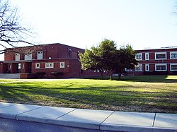
Colonial Heights Middle School
The City of Colonial Heights is served by Colonial Heights Public Schools. There are three elementary schools, Lakeview Elementary School, North Elementary School, Tussing Elementary School; one middle school, Colonial Heights Middle School; and one high school, Colonial Heights High School. All of the schools are accredited by the Virginia Board of Education and by the Southern Association of Colleges and Schools.
Higher education
The area is served by three schools of higher education:
- Virginia State University
- Richard Bland College
- John Tyler Community College
Top employers
According to Chesapeake's 2010 Comprehensive Annual Financial Report,[14] the top employers in the city are:
| # | Employer | # of Employees |
|---|---|---|
| 1 | Wal-Mart | 500-999 |
| 2 | Colonial Heights Public Schools | 500-999 |
| 3 | City of Colonial Heights | 250-499 |
| 4 | Colonial Heights Operation | 100-249 |
| 5 | J. C. Penney | 100-249 |
| 6 | Red Lobster & Olive Garden | 100-249 |
| 7 | Care Advantage | 100-249 |
| 8 | Sears | 100-249 |
| 9 | Target | 100-249 |
| 10 | Priority Automotive Group | 100-249 |
Media
Colonial Heights has two weekly periodicals, both free publications:
- The Colonial Voice, published by the Petersburg Progress-Index.
- Colonial Heights Patriot, published by the Hopewell Publishing Company.
Notable natives
- Jacqueline Cook - Miss Virginia 2000
- Gray Gaulding - NASCAR driver
- Brittany York - Miss North Carolina USA 2011
See also
- National Register of Historic Places listings in Colonial Heights, Virginia
References
- ^ "American FactFinder". United States Census Bureau. http://factfinder2.census.gov. Retrieved 2008-01-31.
- ^ "US Board on Geographic Names". United States Geological Survey. 2007-10-25. http://geonames.usgs.gov. Retrieved 2008-01-31.
- ^ a b "State & County QuickFacts". United States Census Bureau. http://quickfacts.census.gov/qfd/states/51/51570.html. Retrieved January 5, 2014.
- ^ Friends of Lower Appomattox River (FOLAR) Newsletter, 2006
- ^ Progress Index article, May 13, 2007
- ^ a b "National Register Information System". National Register of Historic Places. National Park Service. 2010-07-09. http://nrhp.focus.nps.gov/natreg/docs/All_Data.html.
- ^ "Virginia Landmarks Register". Virginia Department of Historic Resources. http://www.dhr.virginia.gov/registers/register_counties_cities.htm. Retrieved 5 June 2013.
- ^ a b "US Gazetteer files: 2010, 2000, and 1990". United States Census Bureau. 2011-02-12. http://www.census.gov/geo/www/gazetteer/gazette.html. Retrieved 2011-04-23.
- ^ "U.S. Decennial Census". United States Census Bureau. http://www.census.gov/prod/www/decennial.html. Retrieved January 5, 2014.
- ^ "Historical Census Browser". University of Virginia Library. http://mapserver.lib.virginia.edu. Retrieved January 5, 2014.
- ^ "Population of Counties by Decennial Census: 1900 to 1990". United States Census Bureau. http://www.census.gov/population/cencounts/va190090.txt. Retrieved January 5, 2014.
- ^ "Census 2000 PHC-T-4. Ranking Tables for Counties: 1990 and 2000". United States Census Bureau. http://www.census.gov/population/www/cen2000/briefs/phc-t4/tables/tab02.pdf. Retrieved January 5, 2014.
- ^ "American FactFinder". United States Census Bureau. http://factfinder2.census.gov. Retrieved 2011-05-14.
- ^ City of Chesapeake CAFR
- Hawkins, David W., History of Colonial Heights (August, 1947) Virginia Municipal Review.
External links
- Violet Bank, U.S. Route 1 vicinity, Colonial Heights, Colonial Heights, VA: 8 photos and 2 data pages at Historic American Buildings Survey
- City of Colonial Heights

|
Chesterfield County |
| ||
| Chesterfield County | Prince George County | |||
 Colonial Heights, Virginia | ||||
| City of Petersburg | Chesterfield County |
| |||||||||||
Template:National Register of Historic Places in Virginia
| This page uses content from the English language Wikipedia. The original content was at Colonial Heights, Virginia. The list of authors can be seen in the page history. As with this Familypedia wiki, the content of Wikipedia is available under the Creative Commons License. |