| ||||||||||||||
| Carter County, Oklahoma | |
 Location in the state of Oklahoma | |
 Oklahoma's location in the U.S. | |
| Founded | information needed |
|---|---|
| Seat | Ardmore |
| Area - Total - Land - Water |
834 sq mi (2,159 km²) 824 sq mi (2,134 km²) 10 sq mi (26 km²), 1.19% |
| Population - (2000) - Density |
45,621 55/sq mi (21/km²) |
| Time zone | Central: UTC-6/-5 |
| Website | www.brightok.net/chickasaw/ardmore/county/ |
Carter County is a county located in the U.S. state of Oklahoma. As of 2000, the population was 45,621. Its county seat is Ardmore6.
Geography
According to the U.S. Census Bureau, the county has a total area of 2,159 km² (834 sq mi). 2,134 km² (824 sq mi) of it is land and 26 km² (10 sq mi) of it (1.19%) is water.
Major Highways
Adjacent counties
- Garvin County (north)
- Murray County (northeast)
- Johnston County (east)
- Marshall County (southeast)
- Love County (south)
- Jefferson County (southwest)
- Stephens County (northwest)
Demographics

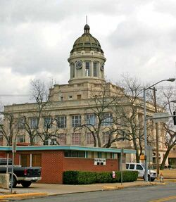
Carter County Courthouse, Downtown Ardmore.
As of the census² of 2000, there were 45,621 people, 17,992 households, and 12,648 families residing in the county. The population density was 21/km² (55/sq mi). There were 20,577 housing units at an average density of 10/km² (25/sq mi). The racial makeup of the county was 77.92% White, 7.60% Black or African American, 8.26% Native American, 0.60% Asian, 0.03% Pacific Islander, 1.13% from other races, and 4.45% from two or more races. 2.78% of the population were Hispanic or Latino of any race.
There were 17,992 households out of which 32.50% had children under the age of 18 living with them, 54.50% were married couples living together, 12.00% had a female householder with no husband present, and 29.70% were non-families. 26.60% of all households were made up of individuals and 12.20% had someone living alone who was 65 years of age or older. The average household size was 2.47 and the average family size was 2.98.
In the county, the population was spread out with 26.20% under the age of 18, 7.90% from 18 to 24, 26.70% from 25 to 44, 23.20% from 45 to 64, and 16.00% who were 65 years of age or older. The median age was 38 years. For every 100 females there were 92.90 males. For every 100 females age 18 and over, there were 89.00 males.
The median income for a household in the county was $29,405, and the median income for a family was $36,729. Males had a median income of $30,018 versus $20,877 for females. The per capita income for the county was $15,511. About 12.70% of families and 16.60% of the population were below the poverty line, including 21.70% of those under age 18 and 12.40% of those age 65 or over.
Cities and towns
External links
| ||||||||||||||||||||
| This page uses content from the English language Wikipedia. The original content was at Carter County, Oklahoma. The list of authors can be seen in the page history. As with this Familypedia wiki, the content of Wikipedia is available under the Creative Commons License. |