| Burgenland Gradišće Őrvidék |
|||
|---|---|---|---|
| — State of Austria — | |||
|
|||
 |
|||
| Country | |||
| Capital | Eisenstadt | ||
| Government | |||
| • Governor | Hans Niessl (SPÖ) | ||
| Area | |||
| • Total | 3,961.80 km2 (1,529.66 sq mi) | ||
| Population | |||
| • Total | 284,900 | ||
| • Density | 72/km2 (190/sq mi) | ||
| Time zone | CET (UTC+1) | ||
| • Summer (DST) | CEST (UTC+2) | ||
| ISO 3166 code | AT-1 | ||
| NUTS Region | AT1 | ||
| Votes in Bundesrat | 3 (of 62) | ||
| Website | http://www.burgenland.at | ||


Burgenland (Croatian: Gradišće, Hungarian: Őrvidék, Felsőőrvidék or Várvidék, Slovene: Gradiščanska, Prekmurian: Gradišče) is the easternmost and least populous state or Land of Austria. It consists of two Statutarstädte (towns with a charter) and seven districts with in total 171 municipalities. It is 166 km long from north to south but much narrower from west to east (only 5 km wide at Sieggraben). The region is a part of the Centrope Project.
Geography[]
Burgenland is the 7th largest of Austria's 9 states, or Bundesländer, at 3,962 km². The highest point in the province is Geschriebenstein, at 884 metres, the lowest point is 114 metres, near Apetlon.
Burgenland borders the Austrian provinces of Niederösterreich and Steiermark to the west, to the northeast it borders Slovakia, Hungary to the east and Slovenia to the farthest south.
Burgenland and Hungary share the Neusiedler See, known for its reeds and shallowness, as well as the mild climate throughout the year. The Neusiedler See is Austria's largest lake serving as a large tourist attraction bringing ornithologists, sailors, and wind and kite surfers into the region north of the lake.
Politics[]
Burgenland's provincial assembly (Landtag) has 36 seats. At the election held on 3 December 2000, the SPÖ won 17 seats, the ÖVP won 13 seats, the FPÖ won 4 seats, and the Green Party won 2 seats. The provincial government is a coalition of the SPÖ and the ÖVP. The voting age for regional elections in Burgenland was reduced to 16 in 2003. In an election held on 9 October 2005, the SPÖ won 19 seats, giving them a majority. The ÖVP retained its 13 seats, the Green Party retained its 2 seats, and the FPÖ fell to 2 seats. [1]
Administrative divisions[]
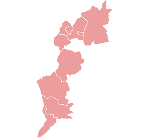
In Burgenland there are 2 Statutarstädte and 7 districts. From north to south:

The districts of Burgenland
Statutarstädte[]
These combine the attributes of district and city.
- Eisenstadt
- Rust
Districts[]
- Neusiedl am See (administrative center Neusiedl am See)
- Eisenstadt-Umgebung (Eisenstadt)
- Mattersburg (Mattersburg)
- Oberpullendorf (Oberpullendorf)
- Oberwart (Oberwart)
- Güssing (Güssing)
- Jennersdorf (Jennersdorf)
História[]
Através da história, o território da atual Burgenland era parte do Império Romano , o Império Huno , o Reino dos ostrogodos , o italiano Reino de Odoacro , o Reino Lombardo , o Avar Khaganate , a eslava Estado de Samo , o franco Império , o Reino da Hungria , a Monarquia de Habsburgo , o Império austríaco , Áustria-Hungria , Áustria , ea II Guerra Mundial Império Alemão .
Pré-história e antiguidade[]
Primeiros indo-europeus povos apareceu nesta região em torno de 3300 aC. Desde o século 4 aC, a área foi dominada por celtas e, no século 1 dC, tornou-se parte do Império Romano . Durante a administração romana, a área era parte da província Pannonia , e mais tarde parte das províncias Pannonia Superior (no século 2) e Pannonia Prima (no século 3). Durante o final do Império Romano , Pannonia Prima província pertencia às unidades administrativas maiores, como Diocese de Pannonia , Prefeitura pretoriana da Ilíria e Prefeitura pretoriana da Itália .
estados germânicos início[]
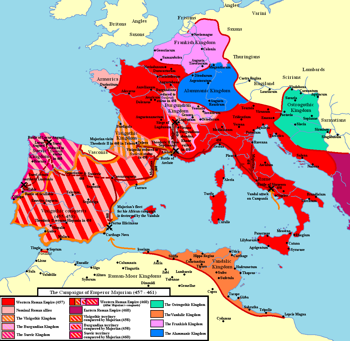

Ostrogothic Kingdom in Pannonia
Primeiros povos germânicos que se estabeleceram na região foram os ostrogodos , que veio para Pannonia em 380 AD. Os ostrogodos tornaram-se aliados da Roma e foram autorizados a se estabelecer em Pannonia com tarefa de defender as fronteiras romanas . No século 5, a área foi conquistada pelos hunos , mas depois de sua derrota, um independente Unido dos ostrogodos em Pannonia foi formado. Território da atual Burgenland se tornou parte da italiana Reino de Odoacro , mas no final do século 5, o Ostrogothic rei Teodorico conquistou este reino e restaurado administração Ostrogothic em Pannonia ocidental.
No século 6, território da atual Burgenland foi incluído em outro estado germânico, o Reino Lombardo . No entanto, os lombardos, posteriormente à esquerda em direcção a Itália ea área ficou sob o controle dos Avars . Resumidamente, no século 7, a área era parte do Slavic Estado de Samo , mas foi posteriormente devolvida ao controle Avar. Após a derrota Avar, no final do século 8, território da atual Burgenland foi incluído no Império Franco . Depois da batalha em Augsburg (955), novos germânicas colonos começaram a se estabelecer na região.
Unido medieval da Hungria[]
Em 1043 um tratado de paz entre Henry III , que se casou mais tarde no mesmo ano, 1043 Agnes de Poitou uma filha do Duque de Aquitaine, e Rei Samuel Aba da Hungria , cujos descendentes de propriedade grandes propriedades na Eslavônia ocidental e cuja relação casar mais tarde uma filha de Agnes de Poitou, fixa a fronteira oeste do Reino da Hungria ao longo dos rios Leitha e Lafnitz, entre outros, mas grandes partes do território de hoje Burgenland foram detidas desde aquela época até 1360 ( Tratado de Brétigny em 1360) pela maioria família nobre da Casa de Gilet , que veio do Ducado da Aquitânia em França medieval durante Roberto II de França , portanto Fraknó (Forchtenstein) tornou-se propriedade da Curia Regia (Royal Court da Hungria) em 1360. o brasão atual de Burgenland imita o brasão de armas do juiz da Curia Regia em 1360. em 20 de setembro de 1058 Agnes de Poitou e Andrew I da Hungria , cujo filho mais tarde se casou com uma filha de Agnes de Poitou, reuniu-se para negociar sobre a fronteira da zona. [1]o território da atual Burgenland permaneceu na fronteira da zona ocidental do Reino medieval da Hungria até o século 16.
A maioria da população era germânica, exceto os húngaros fronteira guardas da fronteira de Março ( Gyepű ). A imigração germânica também foi contínua na Idade Média da vizinha Áustria .
administração Habsburg[]
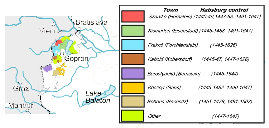
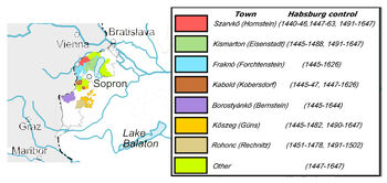
Habsburg mortgages in Burgenland between 15th and 17th centuries
Em 1440 o território da atual Burgenland foi controlada pelos Habsburgos da Áustria, e em 1463 a parte norte do mesmo (com a cidade de Kőszeg ) tornou-se uma hipoteca de território, de acordo com o tratado de paz de Wiener Neustadt . Em 1477 o rei Matthias Corvinus da Hungria retomada da área, mas em 1491 foi hipotecado novamente pelo rei Vladislaus II da Boêmia e Hungria ao imperador Maximiliano I . Em 1647 Emperor Ferdinand II devolveu-o ao Reino da Hungria (que em si foi Habsburg posse em desta vez).
No século 16, Kingdom medieval da Hungria perdeu a sua independência e da sua parte norte-ocidental, que não foi conquistada pelo Império Otomano foi incluído na Monarquia de Habsburgo. Esta posse Habsburg era conhecido como Hungria Real e incluiu território da atual Burgenland. Nos séculos 16-17th alemães protestantes refugiados chegaram em Western Royal Hungria para se abrigar das guerras religiosas do Sacro Império Romano , especialmente a partir da repressão da Reforma nos territórios austríaco, então governada pelos romanos firmemente Habsburgos católicos. Depois de Habsburg vitória militar contra otomanos no final do século 17, Habsburg Reino da Hungria foi ampliado para incluir a maior parte do território do antigo reino medieval da Hungria. Nos séculos 17-18th região de Burgenland foi dominada pelos latifundiários-famílias católicas ricos, por exemplo, o Esterházys e Batthyánys . Em 1867, Monarquia de Habsburgo foi transformada na monarquia dual da Áustria-Hungria e da população de Burgenland de língua alemã encontrou-se dentro da parte húngara da Monarquia.
Dissolução da Áustria-Hungria[]
Após o desaparecimento da monarquia austro-húngaro em 1918, os habitantes alemães de Deutsch-Westungarn (alemão ocidental da Hungria, Burgenland) destina-se a juntar-se na Áustria. Segundo o censo de 1910 291,800 pessoas viviam no território da atual Burgenland. Entre eles 217.072 eram de língua alemã (74%), 43.633 croata de língua (15%) e 26.225 (9%) de língua húngara. Ciganos foram contados de acordo com a sua língua mãe.
A área também foi discutido como o local de um Corredor Checa para a Iugoslávia. A decisão sobre Deutsch-Westungarn foi fixado nos tratados de paz de Saint Germain e Trianon . Apesar dos esforços diplomáticos por Hungria , as partes vencedoras da Primeira Guerra Mundial definir a data da unificação oficial da Burgenland com a Áustria como 28 de agosto de 1921. Na verdade, o estabelecimento do controle da polícia austríaca e costumes foi parado no mesmo dia, impedido por cigarrinhas que ofereceu resistência armada, com o apoio da Hungria.
Estado nono da Áustria[]
Com a ajuda da mediação diplomática italiana, a crise foi quase resolvida no outono de 1921, quando a Hungria comprometeu a desarmar os atiradores até 6 de Novembro de 1921, com a ressalva de uma pesquisa sobre a unificação de certos territórios, incluindo Ödenburg ( Sopron ) , a capital designado de Burgenland, e outros oito comunidades. A pesquisa teve lugar de 14 de dezembro a 16 de dezembro de e resultou em um voto claro (mas duvidava pela Áustria) das pessoas que habitavam estes territórios para a Hungria. Ao contrário do que o outro ( ' Cisleithanian estados austríacos') presente, Burgenland não constituía uma específica Kronland . Devido às suas diferentes raízes históricas no momento da sua formação que não têm suas próprias instituições políticas e administrativas "regionais", tais como um Landtag (assembleia representativa) e Statthalter (governador imperial).
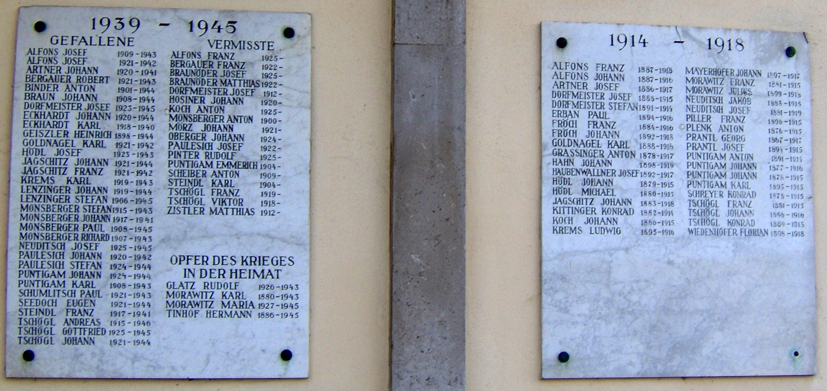
A memorial to soldiers who died in the two World Wars. Krensdorf in Burgenland.
Em 18 de julho de 1922, as primeiras eleições para o Parlamento de Burgenland ocorreu. Para lidar com a transição do Hungarian à jurisdição austríaca, uma série de medidas provisórias foram feitas. O Parlamento decidiu, em 1925, em Eisenstadt como a capital oficial do Burgenland, e mudou-se das várias propriedades provisórias em todo o país para o recém-construído Landhaus em 1929.
O primeiro censo austríaca em 1923 registrou 285,600 pessoas em Burgenland. A composição étnica da província ligeiramente alterado: a porcentagem de alemães aumentou em comparação com 1910 (227,869 pessoas, 80%), enquanto a percentagem de húngaros diminuiu rapidamente (14,931 pessoas, 5%). Esta mudança deveu-se à emigração dos funcionários húngaros e intelectuais após a união com a Áustria.
Em 1923, a emigração para os Estados Unidos da América , que começou no final do século 19, atingiu o seu clímax; em alguns lugares até um quarto da população foi no exterior.
Após o alemão nazista Anschluss da Áustria, a unidade administrativa Burgenland foi dissolvida e integrados nos distritos de Niederdonau (Baixo Danúbio) e Steiermark (Styria).
Além da opressão dos judeus, os grupos étnicos Roma e Sinti também sofreram sob o regime nazista. O KZ Lackenback campo de concentração de ciganos foi localizado na área, como foi KZ Zwaten.[2]
A política de germanização teve efeitos sobre outras minorias étnicas, especialmente Burgenland croatas e húngaros. Escolas minoritários foram fechadas eo uso da língua nativa desencorajado.
Os nazistas começou, com a ajuda de trabalho forçado na sua maioria judaica e habitantes comprometidos, para construir o Ostwall (Eastern Rampart), que mostrou-se totalmente inútil no momento em que as tropas soviéticas cruzaram a fronteira húngaro-austríaca e começou a invadir a Áustria . Nos últimos dias do regime nazista um monte de execuções e morte-marchas dos trabalhadores forçados judeus ocorreu.
minefields[]

Burgenland under Soviet occupation, 1945-1955
Desde 1 de Outubro de 1945, Burgenland foi restabelecida com o apoio soviético e dado às forças soviéticas em troca de Steiermark (Styria), que por sua vez foi ocupada pelo Reino Unido .
Sob a ocupação soviética, as pessoas em Burgenland teve de suportar um período de maus tratos graves e uma progressão económica extremamente lento, o último induzida pela presença, desencorajar investidores das tropas soviéticas. A ocupação soviética terminou com a assinatura do Tratado da Independência austríaca de Viena , em 1955, pelas forças de ocupação.
O brutalmente esmagado revolução húngara em 23 de outubro de 1956 resultou em uma onda de choque de refugiados húngaros na fronteira húngaro-austríaca, especialmente na ponte de Andau ( Brücke von Andau ), que foram recebidos pelos habitantes de Burgenland, com uma enorme quantidade de hospitalidade .
Em 1957, a construção do "Barreira de protecção antifascista" resultou num bulkheading completa da área sob a influência soviética do resto do mundo, fazendo fronteira húngara-austríaca ao lado Burgenland uma zona mortal de campos de minas (na fronteira húngara) e arame farpado, referida como a Cortina de Ferro . Mesmo durante a era da cortina de ferro, trens locais entre o norte eo sul de Burgenland operado como "trens de corredor" (Korridorzüge) – eles tinham suas portas trancadas enquanto atravessavam território húngaro.
Começando em 1965 e terminando em 1971, os campos de minas, foram purificados porque as pessoas eram frequentemente prejudicado por eles, mesmo no lado austríaco da fronteira. Isso poderia muito bem ser tomado como um sinal da União Soviética para a abertura das fronteiras para os países ocidentais, começando no final de 1970.
Vinho e Cortina de Ferro[]
Apesar de Burgenland (especialmente a área ao redor Neusiedler See ) sempre produzindo excelentes vinhos, alguns viticultores em Burgenland acrescentou substâncias ilegais ao seu vinho em meados dos anos 1980 . Quando este foi revelado, Áustria exportações de vinho 's diminuiu dramaticamente. Depois de se recuperar do escândalo, viticultores, na Áustria, não só em Burgenland, passaram a se concentrar na qualidade e na maior parte deixou de produzir vinhos de má qualidade.
Em 27 de julho de 1989, os ministros dos Negócios Estrangeiros da Áustria e da Hungria, Alois Mock e Gyula chifre , cortar a Cortina de Ferro (em alemão : "Eiserner Vorhang"), na aldeia de Klingenbach em um ato simbólico com consequências de longo alcance. Milhares de alemães orientais utilizado esta possibilidade de fugir para o Ocidente. Mais uma vez, os habitantes de Burgenland recebeu com grande hospitalidade. Mais tarde, este foi muitas vezes referido como o tiro de partida da reunificação alemã .
Depois de 1990 Burgenland recuperou o seu papel tradicional como uma ponte entre as partes ocidental e oriental da Europa Central . Ligações transfronteiriças foram reforçadas com a união de Hungria , Eslováquia e Eslovénia a União Europeia em 2004. Todos os três países tornaram-se parte do espaço Schengen no final de 2007, quando os controlos fronteiriços finalmente deixou de existir na região.
Minorities[]
Burgenland has notable Croatian (29,000 - 45,000) and Hungarian (5,000 - 15,000) populations.
Croats[]
The Croats arrived after the devastating Ottoman war in 1532, when the Ottoman army destroyed some settlements in their ethnic territory. The emigration in great haste of the Catholic remained population of western Slavonia into the Burgenland was - as far as possible - organized by the estate owners. In the files of the Parliament of Croatia (sabor) are found for this period numerous references to such resettlements. As reported in the spring of 1538 by the Ban of Croatia, Petar Keglević, who himself owned large estates in western Slavonia, that the country's population at the Ottoman border was preparing to emigrate.[3] Their resettlement by estate owners was finished only in 1584. They have preserved their strong Catholic faith and their language until today, and in the 19th century their national identity grew stronger because of the influence of the National Revival in Croatia. Between 1918 and 1921 Croats opposed the planned annexation of West-Hungary to Austria, and in 1923 seven Croatian villages voted for a return to Hungary. The Croatian Cultural Association of Burgenland was established in 1934. In the Nazi era (1938–45) the Croatian language was officially prohibited, and the state pursued an aggressive policy of Germanization. The Austrian State Treaty of 1955 guaranteed minority rights for every native ethnic minority in Austria but Croats had to fight for the use of their language in schools and offices even in the 1960s and 1970s. In 2000 51 new bilingual village name signs were erected in Burgenland (47 Croatian and 4 Hungarian).
The Burgenland Croatian language is an interesting 16th century dialect which is different from standard Croatian. In minority schools and media the local dialect is used, and it has had a written form since the 17th century (the Gospel was first translated to this dialect in 1711). Today the language is endangered by assimilation, according to the UNESCO "Red Book". The Croats of Burgenland belong to the same group as their relatives on the other side of the modern Austrian-Hungarian border.
Hungarians[]
Hungarians live in the villages of Oberwart/Felsőőr, Unterwart/Alsóőr and Siget in der Wart/Őrisziget. The three villages together are called Upper Őrség (Hun: Felső-Őrség, German: Wart), and they have formed a language island since the 11th century. The other old Hungarian language island in Oberpullendorf/Felsőpulya has almost disappeared today. The Hungarians of Burgenland were "őrök" i.e. guards of the western frontier, and their special dialect is similar to the Székelys in Transylvania. Their cultural centre is Oberwart/Felsőőr. Another distinct Hungarian group were the indentured agricultural workers living on the huge estates north of Neusiedler See. They arrived mainly from the Rábaköz region. After the dissolution of the manors in the mid-20th century this group ceased to exist.
Roma and Jews[]
In addition to Germans, Croats and Hungarians, Burgenland used to have substantial Roma and Jewish populations, wiped out by the Nazi regime. Before their deportation during 1938, the traditionally very religious Burgenland Jews were concentrated in the famous "Seven Communities" (Siebengemeinden / Sheva kehillot) in Eisenstadt, Mattersburg, Kittsee, Frauenkirchen, Kobersdorf, Lackenbach and Deutschkreutz, where they formed a substantial part of the population: e.g., in Lackenbach, 62 % of the population was Jewish as of 1869. After the war, Jews from Burgenland founded the Jerusalem haredi neighbourhood of Kiryat Mattersdorf, reminding of the original name of Mattersburg, once a centre of a famous yeshiva.
Italians[]
There is also a small number of Italians in Burgenland, whose ancestors came to Burgenland mostly as builders of castles and fortified churches in the 17th Century.[4][5] For example, in the little town of Spitzzicken have been in the year 1686 10 families with Italian surnames and 12 families with Croatian surnames. The inhabitants of Spitzzicken got special privileges of personal freedoms at their settlement.[6]
Name[]
As the region wasn't a territorial entity before 1921, it never had an official name. Until the end of World War I the German-speaking western borderland of the Kingdom of Hungary was sometimes unofficially called Deutsch-Westungarn (German West Hungary). The historical region included the border city of Sopron in Hungary (or "Ödenburg" in Austrian-German).
The name Vierburgenland (Land of Four Castles) was created in 1919 by Odo Rötig, a Viennese resident in Sopron. It was derived from the name of the four vármegye of the Kingdom of Hungary (in German Komitate, 'counties') known in Hungarian as Pozsony, Moson, Sopron and Vas, or in German as Pressburg, Wieselburg, Ödenburg and Eisenburg. After the town of Pozsony/Pressburg was assigned to Czechoslovakia the number vier was dropped, but the name was kept because it was deemed to be appropriate for a region with so many old frontier castles. The Burgenland name was officially adopted by the first provincial Landtag in 1922.
In Hungarian the German name is generally accepted but there are three modern alternatives used by minor groups. The Hungarian translation of the German name, Várvidék was invented by László Juhász, an expert of the region in the 1970s and it is becoming increasingly popular especially in touristic publications. The other two names Őrvidék and Felső-Őrvidék derive from the name of the most important old Magyar language island, the Felső-Őrség. This microregion is around the town Felsőőr/Oberwart so these new names are a bit misleading however they are sometimes used.
The Croatian and Slovene names Gradišće and Gradiščansko are translations of the German name. The village of Jennersdorf is no more than 5 kilometers from the Slovenian, as well the Hungarian borders (see the United Slovenia movement).
Alternatively, the Serbs, Czechs and Slovaks call the western shores of the Neusiedler See (lake) surrounding the town of Rust Luzic' or Lusic. However, the descendants of Luzic Serbs, Bosniaks, Croats, Czechs and Slovaks were eventually assimilated into the ethnic German or Hungarian cultures over four centuries.
The province has a long history of Slavic, as well Austrian-German and Hungarian-Magyar settlement. The province's easternmost portion (the shores of the Neusiedler See) carried its own topographical term Seewinkel in Austrian-German. This is the least Austrian-German influenced area since the Hungarian and Slovak borders are less than 10 kilometers away.
Symbols[]
Heraldic description of the coat-of-arms of Burgenland:
Or, standing upon a rock sable, an eagle regardant, wings displayed gules, langued of the same, crowned and armed of the first, on his breast an escutcheon paly of four, of the third and white fur, fimbriated of the field, and in dexter and sinister cantons two crosslets paty sable.
The arms were introduced in 1922 after the new province was created. They were composed from the arms of the two most important medieval noble families of the region, the Counts of Nagymarton and Fraknó (Mattersdorf-Forchtensten, eagle on the rock) and the Counts of Németújvár (Güssing, three bars of red and white fur). [2]
The flag of the province shows two stripes of red and gold, the colours of the coat-of-arms. It was officially confirmed in 1971.
Burgenländische Gemeinschaft[]


Candid of 2007 winner
The Burgenländische Gemeinschaft was founded in 1956, hoping to unite those from Burgenland who have emigrated and now span the globe. The main goals include fostering Burgenland unity, establishing a global community, organizing family trips and gatherings, and reinforcing a sense of homeland attachment. Efforts are also being made to ensure the security of important Burgenland historical documents. Since its inception over 50 years ago, regional chapters have spread throughout the world, with large communities in USA, Canada, Argentina, Switzerland, and Germany. In the USA alone, Burgenländische Gemeinschaft services over 20,000 people. [3]
Also notable is the annual "Miss Brüderschaft der Burgenländer" competition, held in a gala style event in New York. The current title is held by Lillianna Baczeski of Southbury, CT, having received the title from the 2006 winner, Jennifer Tuifl. [4]
Culture[]

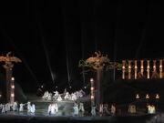
Seefestspiele Mörbisch
The cultural offerings are diverse and especially in the summer famous for the Seefestspiele Mörbisch and the Nova Rock Festival with numerous international popstars.
The permanent exhibition at Forchtenstein Castle shows an impressive collection of the dukes of Esterházy, at whose court at Esterházy Palace worked the world famous musician Joseph Haydn, who composed from the Burgenland Croatian folk-song "V jutro rano se ja stanem" ("In the morning I rise up early") the melody of "Gott erhalte Franz den Kaiser" ("God save Franz the Emperor"), which became the melody of todays national anthem of Germany.[7] There are also cultural events organized by the minorities such as Croatian or Hungarian folk evenings.
Sources[]
- History of Burgenland (PDF file)
External links[]
- Official website
- Burgenland Travel Guide
- Burgenland-Croatian Center
- The Burgenland Bunch Genealogy Group
References[]
- ^ Landeschronik Niederösterreich: 3000 Jahre in Daten, Dokumenten und Bildern, Seite 104, Karl Gutkas, C. Brandstätter, 1990.
- ^ Christine O'Keefe. Concentration Camps.www.tartanplace.com/tartanhistory/concentrationcamps.html
- ^ Kölner geographische Arbeiten, Ausgaben 15-18, Seite 69, Geographisches Institut der Universität zu Köln, 1963
- ^ Residenzen und Landsitze in Wien, Niederösterreich und dem Burgenland, Seite 55, Laurin Luchner, Band 1 von Schlösser in Österreich, Hubert Häusler, Beck Verlag, 1978, ISBN 9783406045073
- ^ Kroaten im Burgenland: eine Dokumentation, Seite 155, Fritz Robak, Europaverlag, 1985.
- ^ Vom Ethnos zur Nationalität, Seite 123, Andreas Moritsch, Oldenbourg Wissenschaftsverlag, 1991.
- ^ Slavonic and East European review, Volume 34, page 2, University of London. School of Slavonic and East European Studies, Committee of American Scholars, Sir Bernard Pares, Robert William Seton-Watson, Harold Williams, Norman Brooke Jopson, Published by the Modern Humanities Research Association for the School of Slavonic and East European Studies, University of London, 1955.
| |||||
| ||||||||||