| ||||||||||||||
| Bremer County, Iowa | |
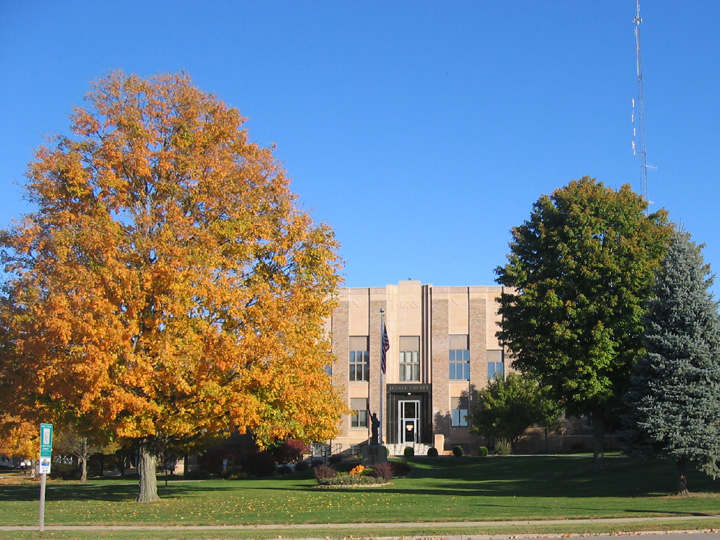 Bremer County Court House
| |
 Location in the state of Iowa | |
 Iowa's location in the U.S. | |
| Founded | 1851 |
|---|---|
| Named for | Fredrika Bremer |
| Seat | Waverly |
| Largest city | Waverly |
| Area - Total - Land - Water |
439 sq mi (1,137 km²) 435 sq mi (1,127 km²) 3.9 sq mi (10 km²), 0.9 |
| Population - (2020) - Density |
24,988 |
| Congressional district | 1st |
| Time zone | Central: UTC-6/-5 |
| Website | https://www.bremercounty.iowa.gov/ |

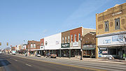
Waverly
Bremer County[lower-alpha 1] is a county in the northeastern part of the U.S. state of Iowa. As of the 2020 census, the population was 24,988.[2] Its county seat is Waverly.[3] The county was named for Fredrika Bremer, a Swedish feminist writer.[4]
Bremer County is included in the Waterloo-Cedar Falls, IA Metropolitan Statistical Area.[5]
Geography[]
According to the U.S. Census Bureau, the county has a total area of 439 square miles (1,140 km2), of which 435 square miles (1,130 km2) is land and 3.9 square miles (10 km2) (0.9%) is water.[6] It is intersected by the Cedar and Wapsipinicon rivers.[7]
Major highways[]
 U.S. Highway 63
- U.S. Highway 218
- Iowa Highway 3
- Iowa Highway 27
- Iowa Highway 93
- Iowa Highway 188
Adjacent counties[]
- Chickasaw County (north)
- Fayette County (east)
- Floyd County (northwest)
- Black Hawk County (south)
- Buchanan County (southeast)
- Butler County (west)
Demographics[]
| Historical populations | |||
|---|---|---|---|
| Census | Pop. | %± | |
| 1860 | 4,915 | ||
| 1870 | 12,528 | 154.9% | |
| 1880 | 14,081 | 12.4% | |
| 1890 | 14,630 | 3.9% | |
| 1900 | 16,305 | 11.4% | |
| 1910 | 15,843 | −2.8% | |
| 1920 | 16,728 | 5.6% | |
| 1930 | 17,046 | 1.9% | |
| 1940 | 17,932 | 5.2% | |
| 1950 | 18,884 | 5.3% | |
| 1960 | 21,108 | 11.8% | |
| 1970 | 22,737 | 7.7% | |
| 1980 | 24,820 | 9.2% | |
| 1990 | 22,813 | −8.1% | |
| 2000 | 23,325 | 2.2% | |
| 2010 | 24,276 | 4.1% | |
| U.S. Decennial Census[8] 1790-1960[9] 1900-1990[10] 1990-2000[11] 2010-2020 | |||


Population of Bremer County from US census data
2020 census[]
The 2020 census recorded a population of 24,988 in the county, with a population density of 56.7708/sq mi (21.9193/km2). 97.01% of the population reported being of one race. 92.39% were non-Hispanic White, 0.96% were Black, 2.04% were Hispanic, 0.18% were Native American, 0.78% were Asian, 0.01% were Native Hawaiian or Pacific Islander and 3.63% were some other race or more than one race. There were 10,484 housing units of which 9,646 were occupied.[2]
2010 census[]
The 2010 census recorded a population of 24,276 in the county, with a population density of 55.42/sq mi (21.400/km2). There were 9,915 housing units, of which 9,385 were occupied.[12]
2000 census[]


2000 Census Age Pyramid for Bremer County
As of the census[13] of 2000, there were 23,325 people, 8,860 households, and 6,326 families residing in the county. The population density was 53 people per square mile (21/km2). There were 9,337 housing units at an average density of 21 per square mile (8/km2). The racial makeup of the county was 98.22% White, 0.48% Black or African American, 0.06% Native American, 0.52% Asian, 0.02% Pacific Islander, 0.10% from other races, and 0.60% from two or more races. 0.56% of the population were Hispanic or Latino of any race.
There were 8,860 households, out of which 32.00% had children under the age of 18 living with them, 62.50% were married couples living together, 6.20% had a female householder with no husband present, and 28.60% were non-families. 24.70% of all households were made up of individuals, and 12.70% had someone living alone who was 65 years of age or older. The average household size was 2.47 and the average family size was 2.95.
In the county, the population was spread out, with 24.10% under the age of 18, 12.00% from 18 to 24, 23.90% from 25 to 44, 23.90% from 45 to 64, and 16.00% who were 65 years of age or older. The median age was 38 years. For every 100 females, there were 93.60 males. For every 100 females age 18 and over, there were 89.30 males.
The median income for a household in the county was $40,826, and the median income for a family was $50,299. Males had a median income of $34,212 versus $22,250 for females. The per capita income for the county was $19,199. About 2.90% of families and 5.10% of the population were below the poverty line, including 4.20% of those under age 18 and 5.80% of those age 65 or over.
Education[]
Wartburg College is located in Waverly.
Waverly-Shell Rock School District
- Waverly-Shell Rock High school
- Waverly-Shell Rock Middle School
- Margaretta Carey Elementary School
- Shell Rock Elementary
- WSR Southeast Elementary
- WSR West Cedar Elementary
- WSR Lied Campus
- St. Paul's Lutheran School
- High school
- Middle school
- Elementary School
- Discoveries Preschool
Janesville Consolidated School District
- S-F High School
- S-F Middle School
- Fredericksburg Elementary
- Durant Elementary
- Fredericksburg Preschool
- Sumner Preschool
Attractions[]
The Bremer County Fair is held at the county fairgrounds in Waverly every year in early August. It celebrated its 135th year in August 2010. Attractions include livestock and craft exhibitions, truck and tractor pulls, commercial and local exhibits, and various contests, performances, and concerts.
The Bremer County Court House, which opened in 1937, is listed on the National Register of Historic Places.[14]
The Bremer County Historical Society and Museum was originally built in 1862 as a stagecoach stop and hotel. It is listed on the National Register of Historic Places.
Communities[]
Cities[]
- Denver
- Frederika
- Janesville
- Plainfield
- Readlyn
- Sumner
- Tripoli
- Waverly
Unincorporated communities[]
- Klinger
- Siegel
- Horton
- Waverly Junction
- Bremer
Townships[]
Bremer County is divided into fourteen townships:
- Dayton
- Douglas
- Franklin
- Frederika
- Fremont
- Jackson
- Jefferson
- Lafayette
- Le Roy
- Maxfield
- Polk
- Sumner No. 2
- Warren
- Washington
Population ranking[]
The population ranking of the following table is based on the 2020 census of Bremer County.[2] † county seat
| Rank | City/Town/etc. | Municipal type | Population (2020 Census) |
|---|---|---|---|
| 1 | † Waverly | City | 10,394 |
| 2 | Sumner (partially in Fayette County) | City | 2,030 |
| 3 | Denver | City | 1,919 |
| 4 | Tripoli | City | 1,191 |
| 5 | Janesville (partially in Black Hawk County) | City | 1,034 |
| 6 | Readlyn | City | 845 |
| 7 | Plainfield | City | 393 |
| 8 | Frederika | City | 204 |
Politics[]
| Year | Republican | Democratic | Third party | |||
|---|---|---|---|---|---|---|
| No. | % | No. | % | No. | % | |
| 2020 | 8,294 | 57.02% | 5,958 | 40.96% | 294 | 2.02% |
| 2016 | 7,208 | 53.24% | 5,356 | 39.56% | 974 | 7.19% |
| 2012 | 6,405 | 47.99% | 6,763 | 50.67% | 178 | 1.33% |
| 2008 | 5,741 | 44.60% | 6,940 | 53.92% | 191 | 1.48% |
| 2004 | 6,665 | 52.16% | 6,025 | 47.15% | 89 | 0.70% |
| 2000 | 5,675 | 50.78% | 5,169 | 46.26% | 331 | 2.96% |
| 1996 | 4,213 | 41.42% | 5,023 | 49.38% | 936 | 9.20% |
| 1992 | 4,482 | 38.26% | 4,774 | 40.75% | 2,458 | 20.98% |
| 1988 | 5,079 | 50.29% | 4,961 | 49.12% | 59 | 0.58% |
| 1984 | 6,895 | 62.37% | 4,084 | 36.94% | 76 | 0.69% |
| 1980 | 6,706 | 59.25% | 3,527 | 31.16% | 1,085 | 9.59% |
| 1976 | 6,252 | 58.51% | 4,203 | 39.34% | 230 | 2.15% |
| 1972 | 6,333 | 65.89% | 3,122 | 32.48% | 156 | 1.62% |
| 1968 | 5,604 | 65.75% | 2,481 | 29.11% | 438 | 5.14% |
| 1964 | 3,880 | 43.41% | 5,045 | 56.44% | 14 | 0.16% |
| 1960 | 6,504 | 66.76% | 3,234 | 33.20% | 4 | 0.04% |
| 1956 | 5,930 | 67.15% | 2,892 | 32.75% | 9 | 0.10% |
| 1952 | 6,806 | 74.12% | 2,363 | 25.73% | 14 | 0.15% |
| 1948 | 3,837 | 51.62% | 3,502 | 47.11% | 94 | 1.26% |
| 1944 | 4,861 | 63.61% | 2,764 | 36.17% | 17 | 0.22% |
| 1940 | 5,374 | 63.26% | 3,103 | 36.53% | 18 | 0.21% |
| 1936 | 3,220 | 38.02% | 5,058 | 59.72% | 192 | 2.27% |
| 1932 | 2,520 | 31.52% | 5,411 | 67.69% | 63 | 0.79% |
| 1928 | 3,879 | 55.08% | 3,146 | 44.67% | 18 | 0.26% |
| 1924 | 3,532 | 48.32% | 911 | 12.46% | 2,867 | 39.22% |
| 1920 | 6,287 | 86.49% | 902 | 12.41% | 80 | 1.10% |
| 1916 | 2,684 | 69.77% | 1,132 | 29.43% | 31 | 0.81% |
| 1912 | 1,013 | 26.91% | 1,944 | 51.65% | 807 | 21.44% |
| 1908 | 1,656 | 45.30% | 1,925 | 52.65% | 75 | 2.05% |
| 1904 | 1,927 | 50.82% | 1,783 | 47.02% | 82 | 2.16% |
| 1900 | 2,178 | 52.46% | 1,929 | 46.46% | 45 | 1.08% |
| 1896 | 2,116 | 54.02% | 1,704 | 43.50% | 97 | 2.48% |
| 1892 | 1,555 | 43.44% | 1,933 | 53.99% | 92 | 2.57% |
| 1888 | 1,613 | 47.43% | 1,728 | 50.81% | 60 | 1.76% |
| 1884 | 1,699 | 53.11% | 1,493 | 46.67% | 7 | 0.22% |
| 1880 | 1,548 | 60.19% | 707 | 27.49% | 317 | 12.33% |
See also[]
- National Register of Historic Places listings in Bremer County, Iowa
- Bremer County Court House
Notes[]
References[]
- ^ Sherman, Barney (September 14, 2017). "Iowa Place Names: A-E". https://www.iowapublicradio.org/2017-09-14/iowa-place-names-a-e.
- ^ a b c "2020 Census State Redistricting Data". United states Census Bureau. https://www2.census.gov/programs-surveys/decennial/2020/data/01-Redistricting_File--PL_94-171/Iowa/.
- ^ "Find a County". National Association of Counties. http://www.naco.org/Counties/Pages/FindACounty.aspx.
- ^ "Bremer County History". Bremer County, Iowa. http://www.co.bremer.ia.us/bremer-county/history.aspx.
- ^ United States Office of Management and Budget. "Update of Statistical Area Definitions and Guidance on Their Uses". pp. 5, 36. https://www.whitehouse.gov/omb/bulletins/fy2006/b06-01.pdf.
- ^ "US Gazetteer files: 2010, 2000, and 1990". United States Census Bureau. February 12, 2011. https://www.census.gov/geographies/reference-files/time-series/geo/gazetteer-files.html.
- ^
 "Bremer". The American Cyclopædia. 1879.
- ^ "U.S. Decennial Census". United States Census Bureau. https://www.census.gov/programs-surveys/decennial-census.html.
- ^ "Historical Census Browser". University of Virginia Library. http://mapserver.lib.virginia.edu.
- ^ "Population of Counties by Decennial Census: 1900 to 1990". United States Census Bureau. https://www.census.gov/population/cencounts/ia190090.txt.
- ^ "Census 2000 PHC-T-4. Ranking Tables for Counties: 1990 and 2000". United States Census Bureau. https://www.census.gov/population/www/cen2000/briefs/phc-t4/tables/tab02.pdf.
- ^ "Population and Housing Occupancy Status: 2010 - State -- County". United States Census Bureau American FactFinder. http://factfinder.census.gov/faces/tableservices/jsf/pages/productview.xhtml?pid=DEC_10_PL_GCTPL2.ST05&prodType=table.
- ^ "U.S. Census website". United States Census Bureau. https://www.census.gov.
- ^ Svendsen, Marlvs A.. "PWA-Era County Courthouses of IA MPS". National Park Service. https://npgallery.nps.gov/NRHP/GetAsset/NRHP/64500856_text.
- ^ Leip, David. "Dave Leip's Atlas of U.S. Presidential Elections". http://uselectionatlas.org/RESULTS.
External links[]

|
Floyd County | Chickasaw County |
| |
| Butler County | Fayette County | |||
 Bremer County, Iowa | ||||
| Black Hawk County | Buchanan County |
| |||||||||||
|
| This page uses content from the English language Wikipedia. The original content was at Bremer County, Iowa. The list of authors can be seen in the page history. As with this Familypedia wiki, the content of Wikipedia is available under the Creative Commons License. |