| ||||||||||||||
| Box Elder County, Utah | |
 Location in the state of Utah | |
 Utah's location in the U.S. | |
| Founded | 1856 |
|---|---|
| Named for | Box elder tree |
| Seat | Brigham City |
| Area - Total - Land - Water |
6,729de sq mi (17,428 km²) 5,723 sq mi (14,823 km²) 1,006 sq mi (2,605 km²), 14.95% |
| Population - (2010) - Density |
49,975 8.7/sq mi (3/km²) |

Box Elder County float, 1912
Box Elder County (details)
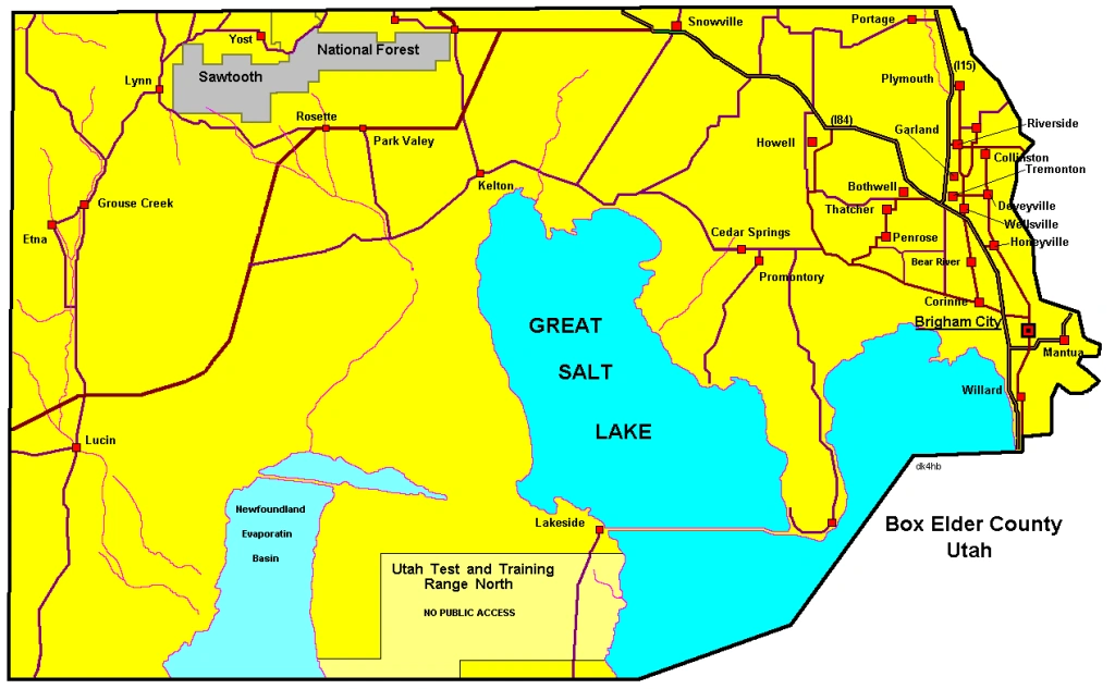
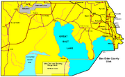
Box Elder County is a county located in the U.S. state of Utah. It lies on the north end of the Great Salt Lake, covering a large area north to the Idaho border and west to the Nevada border. Included in this area are large tracts of barren desert, contrasted by high, forested mountains. The Wasatch Front lies along the south-eastern border, where the main cities are found. As of the 2010 Census, the population was 49,975. It was named for the box elder trees with which the county abounds. Its county seat and largest city is Brigham City.[1]
Box Elder County is part of the Brigham City Micropolitan Statistical Area as well as the Salt Lake City–Ogden–Clearfield Combined Statistical Area.
Geography
According to the U.S. Census Bureau, the county has a total area of 6,729 square miles (17,428.0 km2), of which 5,723 square miles (14,822.5 km2) is land and 1,006 square miles (2,605.5 km2) (14.95%) is water.
In the east lie the Wellsville Mountains, a branch of the Wasatch Range. In the west is a large, mostly uninhabited desert area. The Great Salt Lake lies in the southern portion of the county. Interstate 15 runs through the eastern portion merged with Interstate 84 past Brigham City. They split at Tremonton, with 84 heading northwest past Snowville into Idaho and 15 heading north past Plymouth and Portage into Idaho.
Adjacent counties
- Cache County, Utah - (east)
- Weber County, Utah - (southeast)
- Tooele County, Utah - (south)
- Elko County, Nevada - (west)
- Cassia County, Idaho - (north)
- Oneida County, Idaho - (north)
National protected areas
- Bear River Migratory Bird Refuge
- Caribou-Targhee National Forest (part)
- Golden Spike National Historic Site
- Sawtooth National Forest (part)
- Wasatch-Cache National Forest (part)
Demographics
| Historical populations | |||
|---|---|---|---|
| Census | Pop. | %± | |
| 1860 | 1,608 | ||
| 1870 | 4,855 | 201.9% | |
| 1880 | 6,761 | 39.3% | |
| 1890 | 7,642 | 13.0% | |
| 1900 | 10,009 | 31.0% | |
| 1910 | 13,894 | 38.8% | |
| 1920 | 18,788 | 35.2% | |
| 1930 | 17,810 | −5.2% | |
| 1940 | 18,832 | 5.7% | |
| 1950 | 19,734 | 4.8% | |
| 1960 | 25,061 | 27.0% | |
| 1970 | 28,129 | 12.2% | |
| 1980 | 33,222 | 18.1% | |
| 1990 | 36,485 | 9.8% | |
| 2000 | 42,745 | 17.2% | |
| 2010 | 49,975 | 16.9% | |
| Source: US Census Bureau | |||
As of the census[2] of 2010, there were 49,975 people, 16,058 households, and 12,891 families residing in the county. The population density was 8.73 people per square mile (3.37/km²). There were 17,326 housing units at an average density of 3.03 per square mile (1.17/km²). The racial makeup of the county was 91.77% White, 0.34% Black or African American, 0.82% Native American, 0.89% Asian, 0.17% Pacific Islander, 3.77% from other races, and 2.24% from two or more races. 8.31% of the population were Hispanic or Latino of any race.
There were 16,058 households out of which 41.32% had children under the age of 18 living with them, 67.44% were married couples living together, 8.69% had a female householder with no husband present, and 19.72% were non-families. 17.16% of all households were made up of individuals and 7.39% had someone living alone who was 65 years of age or older. The average household size was 3.09 and the average family size was 3.50.
In the county, the population was spread out with 36.60% under the age of 20, 5.55% from 20 to 24, 25.37% from 25 to 44, 21.35% from 45 to 64, and 11.13% who were 65 years of age or older. The median age was 30.6 years. For every 100 females there were 101.59 males. For every 100 females age 18 and over, there were 96.61 males.
History
19th century
The link-up of the first transcontinental railroad at Promontory Summit, Utah.
20th century
The famous Spiral Jetty was built in 1970.
Cities and towns
Incorporated areas
- Bear River City, incorporated 1886
- Brigham City
- Corinne, incorporated 1870
- Deweyville, incorporated 1969
- Elwood, incorporated 1933
- Fielding, incorporated 1911
- Garland
- Honeyville, incorporated 1916
- Howell, incorporated 1941
- Mantua, incorporated 1911
- Perry, incorporated 1911
- Plymouth, incorporated 1933
- Portage, incorporated 1922
- Snowville, incorporated 1933
- Tremonton, incorporated 1895
- Willard, incorporated 1870
Census designated places (CDPs)
- Riverside
- South Willard
- Thatcher
Other places
- Blue Creek
- Bothwell, incorporated 1930s - 1960s
- Collinston
- Etna
- Grouse Creek
- Kelton
- Lucin
- Park Valley
- Penrose
- Promontory
- Terrace
- Thatcher
- Yost, incorporated 1935 - 1984
Schools
Elementary
- Century
- Discovery
- Fielding
- Foothill
- Garland
- Grouse Creek
- Lake View
- McKinley
- Mountain View
- North Park
- Park Valley
- Snowville
- Three Mile Creek
- Willard
Intermediate
Middle
High
"Speciality Schools"
See also
- National Register of Historic Places listings in Box Elder County, Utah
References
- ^ "Find a County". National Association of Counties. http://www.naco.org/Counties/Pages/FindACounty.aspx. Retrieved 2011-06-07.
- ^ "American FactFinder". United States Census Bureau. http://factfinder2.census.gov. Retrieved 2011-05-14.
External links
 Media related to Box Elder County, Utah at Wikimedia Commons
- Official County Website
- County Health Department

|
Cassia County, Idaho and Oneida County, Idaho |
| ||
| Elko County, Nevada | Cache County | |||
 Box Elder County, Utah | ||||
| Tooele County | Weber County |
| |||||||||||||||||||||||

| |||||||||||||||||||||||
| This page uses content from the English language Wikipedia. The original content was at Box Elder County, Utah. The list of authors can be seen in the page history. As with this Familypedia wiki, the content of Wikipedia is available under the Creative Commons License. |