| Main | Births etc |
|---|
| Boston | |
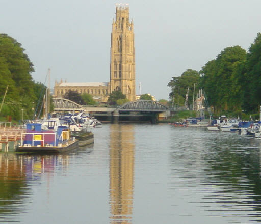 The Boston Stump viewed from the river |
|

Boston | |
| Population | 58,124 |
|---|---|
| OS grid reference | |
| District | Boston |
| Shire county | Lincolnshire |
| Region | East Midlands |
| Country | England |
| Sovereign state | United Kingdom |
| Post town | BOSTON |
| Postcode district | PE21 |
| Dialling code | 01205 |
| Police | Lincolnshire |
| Fire | Lincolnshire |
| Ambulance | East Midlands |
| EU Parliament | East Midlands |
| UK Parliament | Boston and Skegness |
| List of places: UK • England • Lincolnshire | |
Boston (![]() pronunciation (help·info)) is a town and small port in Lincolnshire, on the east coast of England. It is the largest town of the wider Borough of Boston local government district and had a total population of 55,750 at the 2001 census.[1] It is due north of Greenwich on the Prime Meridian.
pronunciation (help·info)) is a town and small port in Lincolnshire, on the east coast of England. It is the largest town of the wider Borough of Boston local government district and had a total population of 55,750 at the 2001 census.[1] It is due north of Greenwich on the Prime Meridian.
Boston's most notable landmark is St Botolph's Church (The Stump), the largest parish church in England[2] with one of the highest towers in England visible in the flat lands of Lincolnshire for miles. Residents of Boston are known as Bostonians. Emigrants from Boston named several other settlements after the town, most notably Boston, Massachusetts.
History[]
Toponymy[]
The name Boston is said to be a contraction of St Botolph's town or of St Botolph's stone. However, fewer people now believe the story, still current, that a settlement in Boston dates from AD 654, when a Saxon monk, named Botolph, established a monastery on the banks of the River Witham. One reason for doubting this is, that in 654, the Witham did not flow near the site of Boston. (The early medieval geography of The Fens was much more fluid than it is today.) Botolph's establishment is most likely to have been in Suffolk. However, he was a popular missionary, to whom many churches between Yorkshire and Sussex, including that of Boston, are dedicated.
Early history[]
The Domesday Book of 1086, does not mention Boston by name. However, the settlement of Skirbeck is covered, as part of the very wealthy manor of Drayton. Skirbeck had two churches and one is likely to have been that dedicated to St Botolph, in what was consequently Botolph's town. Skirbeck ({{{3}}}), is now considered part of Boston, but the name remains, as a church parish and an electoral ward.
The order of importance was the other way round, when the Boston quarter of Skirbeck developed at the head of the Haven, which lies under the present Market Place. At that stage, The Haven was the tidal part of the stream, now represented by the Stone Bridge Drain ({{{3}}}), which carried the water from the East and West Fens. The line of the road through Wide Bargate, to A52 and A16, is likely to have developed on its marine silt levees It led, as it does now, to the relatively high ground at Sibsey ({{{3}}}), thence to Lindsey.
The reason for the original development of the town, away from the centre of Skirbeck, was that Boston lay on the point where navigable tidal water was alongside the land route, which used the Devensian terminal moraine ridge at Sibsey, between the upland of East Lindsey and the three routes to the south of Boston:
- The coastal route, on the marine silts, crossed the mouth of Bicker Haven towards Spalding.
- The Sleaford route, into Kesteven, passed via Swineshead ({{{3}}}), thence following the old course of the River Slea, on its marine silt levee.
- The Salters’ Way route into Kesteven, left Holland from Donington. This route was much more thoroughly developed, in the later Medieval period, by Bridge End Priory ({{{3}}}).
The River Witham seems to have joined The Haven after the flood of September, 1014, having abandoned the port of Drayton, on what subsequently became known as Bicker Haven. The predecessor of Ralph the Staller owned most of both Skirbeck and Drayton, so it was a relatively simple task to transfer his business from Drayton, but Domesday Book of 1086, still records his source of income in Boston under the heading of Drayton, so Boston’s name is famously not mentioned. The Town Bridge still maintains the pre-flood route, along the old Haven bank.
Growth[]


Blackfriars Arts Centre
After the Norman Conquest, Ralph the Staller’s property was taken over by Count Alana. It subsequently came to be attached to the Earldom of Richmond, North Yorkshire and known as the Richmond Fee. It lay on the left bank of The Haven.
During the eleventh and twelfth centuries, Boston grew into a notable town and port [3] The quinzieme was a duty raised on the fifteenth part (6.667%) of the value of merchants' moveable goods at the various trading towns of England. In 1204 when the merchants of London paid £836, those of Boston paid £780b.
Thus by the opening of the thirteenth century, it was already significant in trade with the continent of Europe and ranked as a port of the Hanseatic League [4][5] It was one of the official "staple towns" of England, authorized to carry on the import and export trade. Much of Boston's trade at this time was in wool, and Boston is said by the locals to have been built on it. Apart from wool, Boston also exported salt, produced locally on the Holland coast, grain, produced up-river and lead, produced in Derbyshire and brought via Lincoln, up-river. The wool export trade began to decline in the fifteenth century as the industry shifted to the value-adding business of weaving, which was conducted in other parts of the country, the Hansa merchants quit the town, and Boston's wealth declined.
In the thirteenth and fourteenth centuries four orders of friars arrived in Boston: Dominicans, Franciscans, Carmelites, and Augustinians. As the English Reformation progressed, their friaries were closed by King Henry VIII. The refectory of the Dominican friary was eventually converted into a theatre in 1965, and now houses the Blackfriars Arts Centre.
The town received its charter from Henry VIII in 1545 [6] and Boston had two Members of Parliament from 1552 but with The Haven silted, the town was then, rather living on memories.
17th and 18th centuries[]

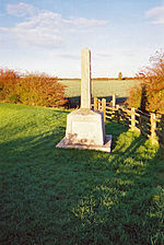
Pilgrim Fathers Memorial
In 1607 a group of pilgrims from Nottinghamshire led by William Brewster and William Bradford attempted to escape pressure to conform with the teaching of the English church by going to The Netherlands from Boston. At that time unsanctioned emigration was illegal, and they were brought before the court in the Guildhall. Most of the pilgrims were released fairly soon and the following year, set sail for The Netherlands, settling in Leiden. In 1620, several of these were among the group who moved to New England in the Mayflower.
Boston remained a hotbed of religious dissent. In 1612 John Cotton became the Vicar of St Botolph's and, although viewed askance by the Church of England for his non-conformist preaching, became responsible for a large increase in Church attendance. He encouraged those who disliked the lack of religious freedom in England to join the Massachusetts Bay Company, and later helped to found the city of Boston, Massachusetts (1630) which he was instrumental in naming. Unable to tolerate the religious situation any longer he eventually emigrated himself in 1633.
At the same time, work on draining the fens to the west of Boston was begun, a scheme which displeased many whose livelihoods were at risk. (One of the sources of livelihood obtained from the fen was fowling, supplying ducks and geese for meat and in addition the processing of their feathers and down for use in mattresses and pillows. The feathery aspect of this is still reflected in the presence of the bedding company named Fogarty, located nearby in Fishtoft.) This and the religious friction put Boston into the parliamentarian camp in the Civil War which in England began in 1642. The chief backer of the drainage locally, Lord Lindsey, was shot in the first battle and the fens returned to their accustomed dampness until after 1750.
The later eighteenth century saw a revival when the Fens began to be effectively drained. The Act of Parliament permitting the embanking and straightening of the fenland Witham was dated 1762. A sluice, called for in the Act, was designed to help scour out The Haven. The land proved to be fertile, and Boston began exporting cereals to London. In 1774 the first financial bank was opened, and in 1776 an Act of Parliament allowed watchmen to begin patrolling the streets at night.
Modern history[]
In the nineteenth century, the names of Howden, a firm located near the Grand Sluice and Tuxford, near the Maud Foster Sluice, were respected among engineers for their steam road locomotives, threshing engines and the like. Howden developed his business from making steam engines for river boats while Tuxford began as a miller and millwright. His mill was once prominent near Skirbeck Church, just to the east of the Maud Foster Drain.
The railway reached the town in 1848 and briefly, it was on the main line from London to the North. The area between the Black Sluice and the railway station was mainly railway yard and the railway company's main depôt. The latter facility moved to Doncaster when the modern main line was opened. Boston remained something of a local railway hub well into the twentieth century, moving the produce of the district and the trade of the dock, plus the excursion trade to Skegness and similar places. But it was much quieter by the time of the Beeching cuts of the 1960s.
Boston once again became a significant port in trade and fishing when, in 1884, the new dock with its associated wharves on The Haven were constructed. It continued as a working port, exporting grain, fertilizer, and importing timber although much of the fishing trade was moved out in the inter-war period. During the First World War many of the town's trawlermen, together with those from Grimsby, were taken prisoner after their ships were sunk by German raiders in the North Sea. Their families did not know what had happened to them till late September 1914. The men were taken to Sennelager camp then on to Ruhleben POW camp where most remained till repatriated in 1918. There is a full report of their homecoming in the Lincolnshire Standard newspaper, January 1918.
The first cinema opened in 1910, and the town was used by film makers during the Second World War to represent The Netherlands when the real thing was not available for filming. In 1913 a new Town Bridge was constructed. Central Park was purchased in 1919, and is now one of the focal points of the town. Electricity came to Boston during the early part of the century, and electrical street lighting was provided from 1924.
The Haven Bridge, which now carries the two trunk roads over the river was opened in 1966 and the new road built in the early 1970s rather separated Skirbeck from Boston but the town largely avoided the development boom of the 1960s. More recently, the new shopping centre named the Pescod Centre opened in 2004, bringing many new shops into the town. Further development is planned.
The town has experienced a decline in recent years both economically and in terms of its reputation. Exacerbated by the decline of farming, the town's traditional role as a service centre for the surrounding agricultural region has been eroded. Many retail businesses in the town are struggling at present and several have closed.
There had been widespread disillusionment with the somewhat perceived apathetic and incompetent running of the local council. In the Local Elections of 2007 this contributed to the overwhelming victory of a small bypass pressure group, over the traditional political parties. Describing their victory the new council leader Richard Austin said: "We knew that the mood of the people of Boston was very black and they really do want something to happen to Boston that isn't happening at the moment. "It's only a reflection of this black mood of the people of Boston."[7] The towns economic decline has been felt more sharply because of a spate of bad news which has tarnished the reputation of Boston. Boston United football club have recently been demoted following on from several years of debt and fraud. In a recent survey the people of Boston were labelled as being the fattest in the country.[8] Another survey highlighted the fact that Boston has the highest number of immigrants per capita of any town in Britain (an estimated 1/4 of the population are immigrants).[9]
Most immigrants have come from East Europe and Portugal. This has led to some social tension, which came to a head during the 2004 European Football Championship, when something akin to rioting[10] occurred briefly with windows being smashed and shops looted, police cars overturned and set alight. Trouble once again erupted in the town, when England were knocked out of the 2006 world cup by Portugal, and there were clashes between riot police and fans from England and Portugal. Some pubs and bars in the area were vandalised with windows being smashed and tables, chairs and glasses being thrown at rival fans, riot police and shops and bars. The local Portuguese bar called 'The Volunteer' was attacked by native youths, who threw missiles, smashed windows and were in possession of petrol bombs. The youths surrounded the bar and trapped the Portuguese supporters inside. Riot police broke the situation up soon after.
However, as a sea port and holder of trade fairs, the town was long accustomed to seamen from the Baltic, Hansa merchants and so on. After the surrounding land was drained, there were influxes of seasonal labourers from other parts of England, from Ireland or other parts of Europe. People occasionally became excited then too – the Hansa merchants finally left after one had been in a fight. But the fights are noticed because of their rarity.
Transport[]
Railway[]
Boston railway station is served by East Midland Trains on the Poacher Line from Grantham to Skegness. It was the southern terminus of the East Lincolnshire Line to Louth and Grimsby until closure in 1970.
Politics[]
Boston Bypass[]
In May 2007 a single-issue political party, the Independent Bypass Group, campaigning for a bypass to be built around Boston, Lincolnshire, took control of Boston Borough Council , removing the Labour Party majority.[11]
Governance[]
Boston received its charter in 1545. It is the main settlement in the Boston local government district of Lincolnshire which includes the unparished town of Boston and eighteen other civil parishes.
Boston is in the East Midlands European Parliament constituency, which elects six members. At the national level, the town is part of the Boston and Skegness parliamentary constituency, currently represented by Conservative Mark Simmonds. The town was previously represented in parliament for 35 years by Conservative Sir Richard Body.
Electoral wards[]
- Central Ward elects one councillor.[12]
- Fenside Ward elects two councillors.[13][14]
- North Ward elects two councillors 1 2.
- Pilgrim Ward elects one councillor.
- Skirbeck Ward elects three councillors 1 2 3.
- South Ward elects one councillor.
- Staniland North Ward elects one councillor.
- Staniland South Ward elects two councillors 1 2.
- West Ward elects one councillor.
- Witham Ward elects two councillors. 1 2
In the local elections of 2007, many local councillors from the major parties were displaced by independent candidates whose main issue as a group is the construction of a road bypass which they believe is being deliberately denied by the Lincoln-centric members of the Lincolnshire County Council.
Demography[]
Population[]
According to the 2001 census, there were 35,124 people residing in Boston town, of whom 48.2% were male and 51.8% were female. Children under five accounted for approximately 5% of the population. 23% of the resident population in Boston were of retirement age.
The population of Boston was believed to have the highest rate of obesity in England, with almost one in three residents clinically obese.
Religion[]
80% of the population are Christians, the next highest religious minority were Muslims making up 0.4%. There are also small Buddhist, Hindu, Jewish and Sikh communities. 11% of the population claim no religion.
Landmarks[]
Some of the most interesting things to be seen in Boston lie not in the usual list of tourist features, but in the area of civil engineering. However, there are remarkable sights of the more usual sort:
The parish church of Saint Botolph is known locally as The Stump and is renowned for its lantern interior and 52 misericords.

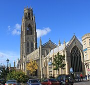
The Stump, viewed from the Market Place. The statue of Herbert Ingram is in the left foreground.
The Grand Sluice is disguised by railway and road bridges, but it is there, keeping the tide out of the Fens and twice a day, allowing the water from the upland to scour the Haven. Not far away, in the opposite direction, was the boyhood home of John Foxe, the author of Foxe's Book of Martyrs.
The Town Bridge maintains the line of the road to Lindsey and from its western end, looking at the river side of the Exchange Building to the right, it is possible to see how the two ends of the building, founded on the natural levees of The Haven, have stood firm while the middle has sunk into the infill of the former river.
From 1552, the Bostonians used to have their jail near The Stump (about where the red car in the photograph is located). This is likely to be where the Scrooby Pilgrims were imprisoned in 1607. The lawyers' quarter is still in use, just to the north of the church.
A statue of the founder of The Illustrated London News, Herbert Ingram is now located in front of The Stump (see photograph). The statue was designed by Alexander Munro and was unveiled in October, 1862. The allegorical figure, at the base of the monument, is a reference to Ingram's efforts to bring the first piped water to the town. He was also instrumental in bringing the railways to Boston. Born in nearby Paddock Grove, son of a butcher,[15] he was also MP for Boston, from 1856, until his death in 1860, in a shipping accident on Lake Michigan.
The market, held on Saturdays and Wednesdays, in the Market Place and also on Wide Bargate on Wednesday. Market Place and Strait Bargate are the retail hub of the town centre. Coincidentally, No.1 Market Place and No.1 Strait Bargate are the same building, F. Hinds jewellers.


Maud Foster Mill
The seven-storeyed Maud Foster Tower Windmill, completed in 1819, by millwrights Norman & Smithson of Kingston upon Hull for Issac and Thomas Reckitt, is currently the tallest operating windmill in England (80 ft/24.4 metres to the top of the cap), following extensive restoration during the 1980s and early 1990s and is now a working museum. The tall mill, without the usual tar coating in Lincs, stands on the dyke above the drain it is named after and is unusual in having an odd number (five) of sails.
The Boston Guildhall in which the Pilgrim Fathers were tried, on the first floor, by the magistrates, was converted into a museum in 1929. The American Room was opened by the U.S. Ambassador, Joseph P. Kennedy, Sr., in 1938. The cells in which the pilgrims are said to have been held at the time of their trial are on the ground floor. In 2005 it is closed for repair and refurbishment. – The Pilgrim Fathers Memorial is located on the north bank of The Haven a few miles outside the town. It was here at Scotia Creek, that the pilgrims made their first attempt to leave for Holland in 1607.


Hussey Tower
The ruined Hussey Tower is all that remains of a medieval brick fortified house.[16] Two miles east, Rochford Tower is another medieval tower house.[17]
In Skirbeck Quarter, on the right bank of The Haven, is the Black Sluice, the outfall of the South Forty-Foot Drain.
The Prime Meridian passes through the eastern side of Boston, marked by the fairly modern, suburban Meridian Road (Template:Mmukpc), which straddles the line the road was named after.
The oldest landmark is the Boston May Fair which has been held in the town every year since at least 1125. This fair is held during the first week of May, and is one of the largest outdoor fairs in the country. By tradition, the fair was officially opened by the incumbent mayor at 11 am on the May Day bank holiday. However this is now not the case.
The Haven Gallery, opened in 2005, was closed to the public in 2010 in a costcutting measure by Boston Borough Council.
Freiston Shore is a nature reserve, and lies on The Wash coast north of the mouth of The Haven.
In popular culture[]
- The novel The Last Dickens is set in Boston.
- Boston is often assumed to be the prototype for Flaxborough, in the detective novels of Colin Watson
- Boston was the birthplace of the 19th Century author and poet Jean Ingelow
Local economy[]
There is a Tesco on New Hammond Beck Road, near Swineshead Road (A52) to the west of the town. There is an Asda on Sleaford Road (A52) close to the railway station. There are Co-ops on Argyle Street (A1137), on West Street and on Eastwood Road, heading east out of the town. Wetherspoons have a pub, the Moon Under Water, close to the bridge over the river on the High Street. Bingo is played at The Gliderdrome Bingo Hall, Boston's original bingo. The Gliderdrome was famous in the 1960s for attracting top Motown acts as well as various other artists including, in the 1970s, Elton John and Marc Bolan & T.Rex and in the early 1980s "Yam Hologram". It is one of the very few English venues at which soul legend Otis Redding has performed. It still holds dances a few times each year. Marc Bolan & T.Rex recorded a live album at the Gliderdrome named 'Live at the Boston Gliderdrome' in 1972 which was released on CD in 2001.
A new shopping park opened in January 2007 on Horncastle Road. This new development has brought several large companies to the town for the first time. These include T.K. Maxx, Bathstore, Netto, SportsDirect.com and Gala Bingo. Dynamic Cassette International (Jet Tec) is one of the biggest manufacturing employers in the town.
Sport[]
The Princess Royal Arena is located on The Boardsides, just outside Boston. This stadium is unique owing to its attention given to the disabled.
Football[]
The town has two non-league football clubs. The more senior Boston United, nicknamed The Pilgrims, play in the Northern Premier League. The stadium is currently located on York Street in the centre of the town and has an approximate capacity of 6,200. The town's second club is Boston Town nicknamed The Poachers, who play in the United Counties Football League. Home games are played at their stadium on Tattershall Road, on the outskirts of Boston. The two traditionally play each other at the beginning of each season.
Rugby[]
Boston Rugby Club is also located at the Princess Royal Arena. The team play in blue shirts with narrow white stripes.It first started in 1927 by Ernst Clark, a gentleman with an interest in giving his boys and their friends something to do, or rather something to keep them out of trouble.
Rowing[]
Boston Rowing Club, near Carlton Road, hosts the annual 31 mile Boston Rowing Marathon each year in mid-September. Crews from all over the UK compete, starting at Brayford Pool in Lincoln, finishing in times from three to six hours.
Speedway[]
Speedway racing was staged at a stadium in New Hammond Beck Road in the 1970s and 1980s. The Boston Barracudas raced in the British League Division Two, (now the Premier League) and in 1973 completed a clean sweap winning the League, Knock-out Cup, and Arthur Price won the League Individual Championship, after the New Hammond Beck Road Stadium was sold for re-development in 1988 attempts to secure a new venue failed in the 1990s a team, known as Boston, raced in the Conference League out of King's Lynn ,
Health[]
Boston has been shown to have the highest obesity rate of any town in the United Kingdom, with one-third of adults (31%) in the town considered clinically obese. Six out of seven people fail to hit the target of three half-hour sessions a week of moderate intensity sport or active recreation. This obesity has been linked to social deprivation.[18]
Education[]
Secondary schools[]
Boston Grammar School, an all male selective school, is on South End, near the John Adams Way (A52/A16), Geoff Moulder Leisure Centre and River Witham. Its female analogue, Boston High School is on Spilsby Road (A16), in the north of the town next to the Pilgrim Hospital. These two are the only schools in the town to have sixth-forms. They were planning to join schools and make a federation but financial issues prevented that from happening. Haven High Technology College is on Marian Road to the north of the town. Boston College is on Skirbeck Road.
Kitwood Boys School and Kitwood Girls' School were both examples of the post-war, secondary modern school system. The boys' school located in Mill Road was closed in 1993 and now forms part of Boston College. The former girls' school has now become Haven High Technology College
Boston currently has the lowest standard of education in Lincolnshire, with only 72% of GCSE students receiving grades above C.
Town twinning[]
Boston's twin towns include:
|
Destinations[]

|
Lincoln, Tattershall, Dogdyke, Langrick, Brothertoft, | Horncastle, Midville, Stickney, Carrington, Sibsey, Frithville, | Skegness, Wainfleet, Friskney, Wrangle, Leverton, Benington, |
|
| North Forty Foot Bank, Hubberts Bridge, Heckington, Sleaford, | Freiston, Butterwick, | |||
 Boston | ||||
| Swineshead, Bicker, Donington, Bourne | Wyberton, Frampton, Kirton, Spalding, | Fishtoft, Freiston Shore, |
See also[]
- Boston United F.C.
- Dynamic Cassette International
- List of road protests in the UK and Ireland – Boston Bypass is listed
Notes[]
- ^ "Neighbourhood Statistics". Office of National Statistics. http://neighbourhood.statistics.gov.uk/dissemination/LeadKeyFigures.do?a=7&b=277037&c=PE21+8XY&d=13&e=15&g=466980&i=1001x1003x1004&m=0&r=0&s=1307220270708&enc=1. Retrieved 4 June 2011.
- ^ "Church sells bits of Boston Stump". BBC News. 3 November 2005. http://news.bbc.co.uk/1/hi/england/lincolnshire/4403100.stm. Retrieved 18 August 2009.
- ^ Morris 1979, p. 101
- ^ Borough of Boston (no date, probable 1970s). Official Guide to Boston. Ed J Burrow & Co Ltd. p. 13 paragraph 1.
- ^ H. W. Nicholson, ed (1986). A Short History Of Boston (4th Edition ed.). Guardian Press of Boston. p. 2.
- ^ Pishey Thompson (1856). History and Antiquities of Boston. Longman. http://books.google.co.uk/books?id=ZY0NAAAAIAAJ&printsec=frontcover&dq=boston+pishey+thompson&source=bl&ots=JCVuIOKSoA&sig=7MK_F3VQ675c14s3xOjsErn1aQA&hl=en&ei=If-mTdzLN4W2hAej3tzeCQ&sa=X&oi=book_result&ct=result&resnum=2&ved=0CCIQ6AEwAQ#v=onepage&q=1545&f=false. Retrieved April 14, 2011.
- ^ "Bypass group wins race for Boston". BBC News. 2007-05-04. http://news.bbc.co.uk/1/hi/england/lincolnshire/6603565.stm. Retrieved 2010-04-01.
- ^ <http://www.timesonline.co.uk/tol/news/uk/article601137.ece>
- ^ Harvey, Oliver (2008-04-24). "Welcome to Boston Europe". The Sun (London). http://www.thesun.co.uk/sol/homepage/news/article1082248.ece.
- ^ "England | Lincolnshire | Three charged after Boston 'riot'". BBC News. 2004-06-15. http://news.bbc.co.uk/1/hi/england/lincolnshire/3810213.stm. Retrieved 2009-03-15.
- ^ "Bypass group wins race for Boston". BBC. 2007-05-04. http://news.bbc.co.uk/1/hi/england/lincolnshire/6603565.stm. Retrieved 2008-01-21.
- ^ "Central Ward councillor 1". Boston.gov.uk. http://www.boston.gov.uk/index.php?option=com_content&task=view&id=658&Itemid=3351. Retrieved 2007-07-30.
- ^ 1 "Fenside Ward councillor 1". Boston.gov.uk. http://www.boston.gov.uk/index.php?option=com_content&task=view&id=663&Itemid=3351 1. Retrieved 2007-07-30.
- ^ 2 "Fenside Ward councillor 2". Boston.gov.uk. http://www.boston.gov.uk/index.php?option=com_content&task=view&id=662&Itemid=3351 2. Retrieved 2007-07-30.
- ^ The Oxford Book of National Biography – September 2004, quoted on The Early History of The Illustrated London News
- ^ "Hussey Tower". britishlistedbuildings.co.uk. http://www.britishlistedbuildings.co.uk/en-486443-hussey-tower-boston. Retrieved 2011-03-08.
- ^ "Rochford Tower". Pastscape. http://www.pastscape.org.uk/hob.aspx?hob_id=353869. Retrieved 2011-06-14.
- ^ Carter, Helen (2006-10-12). "Lincolnshire: home of the porker?". London: The Guardian. http://www.guardian.co.uk/medicine/story/0,,1920152,00.html. Retrieved 2007-07-30.
References[]
- Morris, J. ed. Domesday Book Vol. 31, Lincolnshire Parts 1 & 2. Chichester. (1986) ISBN 0-85033-598-1.
- Morris, AEJ (1979). History of Urban Form. John Wiley & Sons. ISBN 0-7114-5512-0.
- Thompson, P. The History and Antiquities of Boston etc. Boston, London & Boston Mass. (1856). facsimile edn. (1997) ISBN 0-948639-20-2.
- Note a: Morris, J. (Domesday Book for Lincolnshire: Landowner 12 entry 67).
- Note b: Thompson, P. Division VIII.
External links[]
Archival material
- This appears to have been lifted from a nineteenth century trade directory. It would therefore, itself be an historical text.
- Boston's entry in the Parliamentary Gazetteer of 1843–4
- The Parliamentary Boundary Commissioners’ Report on Boston Borough, 1831
Local Economy
Local newspaper
Organisations
- St Nicholas' Church, Skirbeck, Boston – Parish Church Website
- There is now an arts centre called The Haven.
- Victoria Group – Port of Boston
Special interest
Videos
- Boston Stump on YouTube, retrieved 18 December 2010
- Boston town centre streets on YouTube, retrieved 18 December 2010
| ||||||||||||||||||||||||||||||||||||||||||||||

| ||||||||||||||||
| This page uses content from the English language Wikipedia. The original content was at Boston, Lincolnshire. The list of authors can be seen in the page history. As with this Familypedia wiki, the content of Wikipedia is available under the Creative Commons License. |