| ||||||||||||||
| Boone County | ||
| County | ||
| ||
| Name origin: Named for Daniel Boone | ||
| Country | United States | |
|---|---|---|
| State | Missouri | |
| Region | Mid-Missouri | |
| Metro area | Columbia | |
| County seat | Columbia | |
| - elevation | 705 ft (215 m) | |
| - coordinates | ||
| Area | 691.31 sq mi (1,790 km²) | |
| - land | 685.43 sq mi (1,775 km²) | |
| - water | 5.88 sq mi (15 km²) | |
| Population | 162,642 (2010) | |
| Density | 237.4 / sq mi (92 / km²) | |
| Incorporated | November 16, 1820 | |
| Timezone | Central Standard Time (UTC-6) | |
| - summer (DST) | Eastern Daylight Time (UTC-5) | |
| Area code | 573 | |
 Location in the state of Missouri
| ||
 Location of Missouri in the US
| ||
| Wikimedia Commons: Boone County, Missouri | ||
| Website: www.showmeboone.com | ||
| [1][2] | ||

Boone County is a county centrally located in the U.S. state of Missouri. It is the eighth most populous county in Missouri. In 2010, the population was 162,642.[1] Its county seat, Columbia, is the fifth largest city in Missouri and the anchor city of the Columbia Metropolitan Area.
History
Boone County was organized on November 16, 1820, from a portion of the territorial Howard County. The area was known as Boone's Lick Country, because of a salt lick which sons of Daniel Boone relied on for their stock.

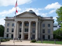
The Boone County Courthouse at the Boone County Government Complex.
While considered Midwestern in modern times, Boone County was settled primarily from migrants from the Upper South states of Kentucky, Tennessee and Virginia. They brought slaves and slaveholding traditions with them, and quickly started cultivating crops similar to those in Middle Tennessee and Kentucky: hemp and tobacco. Boone was one of several counties settled mostly by southerners to the north and south of the Missouri River. Given their culture and traditions, this area became known as Little Dixie and Boone was at its heart.[3] In 1860 slaves made up 25 percent or more of the county's population.[4]
Demographics
As of the census[5] of 2000, there were 135,454 people, 53,094 households, and 31,378 families residing in the county. The population density was 198 people per square mile (76/km²). There were 56,678 housing units at an average density of 83 per square mile (32/km²). The racial makeup of the county was 85.43% White, 8.54% Black or African American, 0.42% Native American, 2.96% Asian, 0.03% Pacific Islander, 0.69% from other races, and 1.93% from two or more races. 1.78% of the population were Hispanic or Latino of any race. 24.6% claimed German, 12.3% American, 11.2% English and 9.8% Irish ancestry according to Census 2000.
There were 53,094 households out of which 30.30% had children under the age of 18 living with them, 45.50% were married couples living together, 10.40% had a female householder with no husband present, and 40.90% were non-families. 28.70% of all households were made up of individuals and 6.20% had someone living alone who was 65 years of age or older. The average household size was 2.38 and the average family size was 2.97.
In the county the population was spread out with 22.80% under the age of 18, 19.90% from 18 to 24, 29.90% from 25 to 44, 18.80% from 45 to 64, and 8.60% who were 65 years of age or older. The median age was 30 years. For every 100 females there were 93.50 males. For every 100 females age 18 and over, there were 90.90 males.
The median income for a household in the county was $37,485, and the median income for a family was $51,210. Males had a median income of $33,304 versus $25,990 for females. The per capita income for the county was $19,844. About 7.60% of families and 14.50% of the population were below the poverty line, including 12.10% of those under age 18 and 5.90% of those age 65 or over.
There are 121,319 registered voters.[6]
Geography

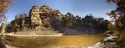
The Pinnacles, a natural formation carved by hundreds of years of flowing water, just north of Columbia.
According to the 2000 census, the county has a total area of 691.31 square miles (1,790.5 km2), of which 685.43 square miles (1,775.3 km2) (or 99.15%) is land and 5.88 square miles (15.2 km2) (or 0.85%) is water.[7] The Missouri River makes up the southern border of the county.
National protected area
- Mark Twain National Forest (part)
Location

|
Howard County | Randolph County | Audrain County |
|
| Cooper County | Callaway County | |||
 Boone County, Missouri | ||||
| Moniteau County | Cole County |
Transportation
Major highways
 Interstate 70
- U.S. Route 40
- U.S. Route 63
- Route 22
- Route 124
- Route 163
- Route 740
Government
Boone County is a Class I non-charter county.
Cities and towns
|
|
|
See also
- List of counties in Missouri
- Missouri census statistical areas
- National Register of Historic Places listings in Boone County, Missouri
References
- ^ a b "2010 Census Data". U.S Census Bureau. http://2010.census.gov/2010census/data/. Retrieved 2010-03-04.
- ^ "Population Estimates for Missouri Counties 2008" (XLS). U.S. Census Bureau. http://www.census.gov/popest/counties/tables/CO-EST2008-01-29.xls.
- ^ The Story of Little Dixie, Missouri, Missouri Division, Sons of Confederate Veterans, accessed 3 June 2008
- ^ T. J. Stiles, Jesse James: The Last Rebel of the Civil War, New York: Vintage Books, 2003, pp.10-11
- ^ "American FactFinder". United States Census Bureau. http://factfinder.census.gov. Retrieved 2008-01-31.
- ^ Registered Voters in Missouri 2008
- ^ "Census 2000 U.S. Gazetteer Files: Counties". United States Census. http://www.census.gov/tiger/tms/gazetteer/county2k.txt. Retrieved 2011-02-13.
External links
- Digitized 1930 Plat Book of Boone County from University of Missouri Division of Special Collections, Archives, and Rare Books
| |||||||||||||||||||||||

| This page uses content from the English language Wikipedia. The original content was at Boone County, Missouri. The list of authors can be seen in the page history. As with this Familypedia wiki, the content of Wikipedia is available under the Creative Commons License. |