| ||||||||||||||
| Bellary district Bellary ಬಳ್ಳಾರಿ |
|
|---|---|
| — district — | |

Bellary district |
|
| Coordinates: Coordinates: | |
| Country | |
| State | Karnataka |
| Headquarters | Bellary |
| Talukas | Bellary, Hosapete, Kampli, Hoovina Hadagali, Kudligi, Sanduru, Siraguppa, Hagaribommanahalli |
| Area | |
| • Total | 8,447 km2 (3,261 sq mi) |
| Elevation | 449 m (1,473 ft) |
| Population (2003) | |
| • Total | 2,245,000 |
| • Density | 196/km2 (510/sq mi) |
| Languages | |
| • Official | Kannada |
| Time zone | IST (UTC+5:30) |
| PIN | 5831** |
| Telephone code | ?? |
| Vehicle registration | ?? |
| Website | bellary.nic.in |
Bellary (Kannada: ಬಳ್ಳಾರಿ; pronounced [ˈbəɭɭari]) is a district in Karnataka state, India.
Hot and dry summers, Historical sites, Farm Land and Rich minerals characterize Bellary district. Also the home of famous Vijaya Nagara Empire World Heritage Site. Recently making headlines with mining industry.
History[]
Earlier Bellary District was part of Rayala Seema, a region in today's state Andhra Pradesh. With the formation of states based on languages Bellary became part of Karnataka.
Look at the history section of the Wikipedia entry for Bellary city
Geography[]
Bellary district is spread from southwest to northeast and is situated on the eastern side of Karnataka state. The district is 15° 30’ and 15°50’ north latitude and 75° 40’ and 77° 11’ east longitude. The geographical area is 8447 km².
This district is bounded by Raichur District on the north, Koppal District on the west, Chitradurga District and Davanagere District on the south, and Anantapur District and Kurnool District of Andhra Pradesh on the east.
The normal rainfall is 639 mm.
Administration[]
Bellary comes under the administrative control of Gulbarga division and development jurisdiction of H.K.D.B, Gulbarga.
It has 2 revenue sub divisions, Bellary subdivision and Hosapete subdivision, which in all have seven taluks. The Bellary subdivision has 3 taluks, while there are four taluks in Hospet subdivision. There are 27 hoblies, one Corporation, one City Municipal Council, two town municipality, six town panchayats, 542 revenue villages, and 436 thandas/habitations.
As per 2003 census the population of the district stood at 2,245,000. The rural population constitute 70%. The density of population is 196 per km²., which is much lower than the state average of 235 per km². However the decimal growth rate for 1981-91 was 26.92% which is higher than the state growth rate of 21.12% The scheduled caste/scheduled tribe population constitute 28% of the total population. The sex-ratio was 965, which is slightly higher than the state average of 960.
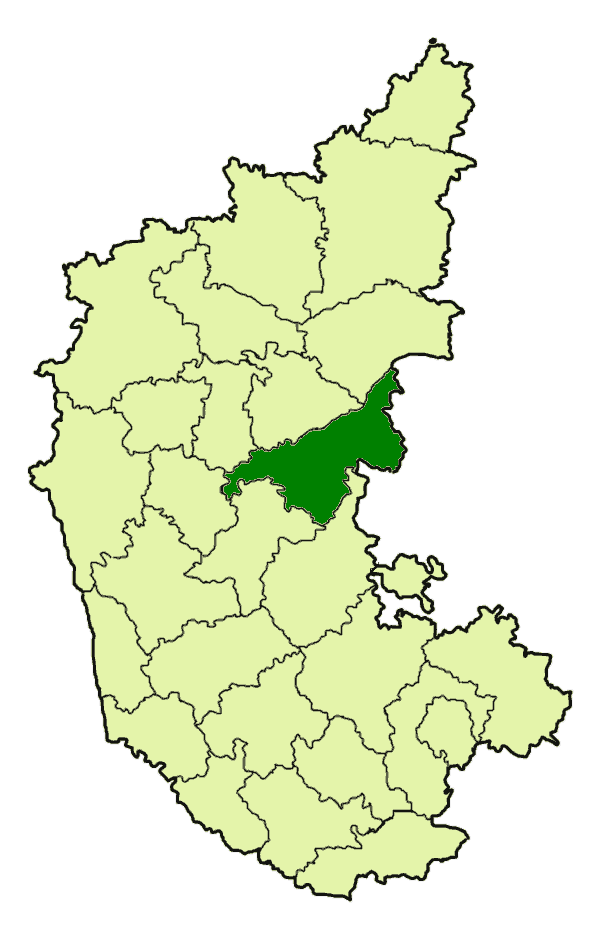
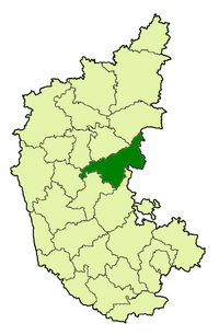
Location of the Bellary district with respect to the other Districts in Karnataka
Economy[]
The major occupation of this district is agriculture and 75% total labour force is dependent on agriculture for its livelihood. The important crops grown are cotton, jowar, groundnut, rice, sunflower and cereals. The net irrigated area is 37% to the net area sown. The pattern of land utilization in the district is as under (1997–1998).
The main source of irrigation is Tungabhadra Dam. The Canal network accounts for 64% of irrigated area. The important rivers are Tungabhadra, Hagari and Chikkahagari. The western taluks of the district are dogged with scarcity conditions with the failure of rains during successive years. However during the current year and preceding year heavy rains have created havoc in the district leaving many in lurch.
Industries[]
Bellary district is rich in natural resources which need to be tapped to a great extent for overall development of the district. This district is endowed with rich mineral resources. It has both metallic and non-metallic minerals. The metallic minerals include iron ore, manganese ore, redoxide, gold, copper and lead. The non-metallic minerals include andalusite, asbestos, corundum, clay, dolomite, limestone, limekankan, moulding sand, quartz, soap stone, granite and red ochre. The metallic minerals are abundant is only three talukas, Sanduru, Hosapete and Bellary in the order of mining activity intensity. The annual production of Iron ore is anywhere between 2.75 to 4.5 million tonnes, and manganese ore between 0.13 million tonnes to 0.3 million tonnes (1991). Bellary presently is the second fastest growing city in the state of Karnataka after Bengaluru. The real estate prices have already started to shoot as more and more industries are finding their way into this city. Bellary to its credit has the second largest single rock mountain in the world.
Mining Industry[]
Bellary district has 25 % of India's Iron ore reserves. Till 1994 handful of mining companies operated here including state owned NMDC. Later Govt issued mining licenses to many private operators. Mining Industry boomed with surge in Iron Ore prices due to demand from emerging China. Mining license allocation policy from Central govt was based on Political Nepotism rather than merit. Flawed mining policy lead to wide spread illegal mining. Since year 2000 money from illegal money flowed into electoral politics of Karnataka State. This lead to emergence of powerful Reddy Brothers to state politics. Reddy brothers fueled money from illegal mining into politics, there by King Makers of Karnataka State politics. Ombudsman report on mining in Karnataka state found that the promoters of privately owned mining companies in the Bellary region paid off politicians, and then joined politics themselves, rising to positions in the Karnataka state government. These mining businessmen-turned-politicians exerted so much influence over the local officials that the Indian media began describing Bellary as a "new republic".[1][2]
Despite the availability of minerals in large quantities, this district is considered to be an industrially backward district. There are 23 units of large and medium scale industries in this district with an investment of Rs.447.76 crores employing around 9,222 persons At present it occupies ninth place in the state. Sathavahana Ispat Ltd. is the first Pig Iron plant setup in the region to utilize the abundant iron ore reserves available, Kirloskar was the next to follow with their Pig Iron plant. However with the commissioning of Jindal Vijayanagar Steel Limited at Hosapete, the industry scenario of this district underwent sea changes. It is understood that Mukund Steels and Kalyani Steels have started industries in this area. The inflow of investment into these industries would be around Rs.30,000 Crores. The district will therefore come under heavy pressure on basic infrastructure such as power, communication, health, education and police stations which again invite heavy investment to create the needed infrastructure. Urgent action is needed to pool the resources under various sectors such as District Sector, State sector, Border Area Development, HKDB etc., and prepare a perspective plan to the emerging challenges. It has already drawn the attention of social scientists economists, administrators and other related functionaries to think over the possible positive and negative impact in this area.The ruthless and illegal mining of iron ore in the district has caused envoirnmental damage and also wide ranging social and economical impact.Despite large deposits of iron the mining mafia of Reddy brothers assisted by the backward caste goondas such a Nayak (Byada in kannada), looting precious mines relentlessly with the support of BJP leaders form both centre and state. resulted in capitlism. now the reddys have grown to topple governments in several states. key aids of gali Janardhana reddy are Sriramulu, Suresh Babu, Nagendra, Alikhan, Verma, Chandru, Ragavacharulu
Demographics[]
According to the 2011 census Bellary district has a population of 2,532,383,[3] roughly equal to the nation of Kuwait[4] or the US state of Nevada.[5] This gives it a ranking of 168th in India (out of a total of 640).[3] The district has a population density of 300 inhabitants per square kilometre (780 /sq mi) .[3] Its population growth rate over the decade 2001-2011 was 24.92 %.[3] Bellary has a sex ratio of 978 females for every 1000 males,[3] and a literacy rate of 67.85 %.[3]
Tourism[]
- 353 km from Bangalore and 74 km from Bellary is Hampi, known for the ruins of Vijayanagara.
- 300 km from Bangalore and 60 km from Bellary is Bommaghatta, known for Lord Hulikunteraya temple.
References[]
- ^ India mining scandal: G Janardhana Reddy remanded
- ^ Why mining in India is a source of corruption?
- ^ a b c d e f "District Census 2011". Census2011.co.in. 2011. http://www.census2011.co.in/district.php. Retrieved 2011-09-30.
- ^ US Directorate of Intelligence. "Country Comparison:Population". https://www.cia.gov/library/publications/the-world-factbook/rankorder/2119rank.html. Retrieved 2011-10-01. "Kuwait 2,595,62"
- ^ "2010 Resident Population Data". U. S. Census Bureau. http://2010.census.gov/2010census/data/apportionment-pop-text.php. Retrieved 2011-09-30. "Nevada 2,700,551"
External links[]

|
Gadag district | Koppal district | Raichur district |
|
| Haveri district | Kurnool district, Andhra Pradesh | |||
 Bellary district | ||||
| Davanagere district | Chitradurga district | Anantapur district, Andhra Pradesh |
| |||||||||||||||||||||||||||||
| ||||||||||||||
| This page uses content from the English language Wikipedia. The original content was at Bellary district. The list of authors can be seen in the page history. As with this Familypedia wiki, the content of Wikipedia is available under the Creative Commons License. |