| Main | Births etc |
|---|
| Barsingerhorn | |
|---|---|
| — Village — | |
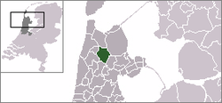
| The town centre (dark green) and the statistical district (light green) of Barsingerhorn in the former municipality of Niedorp. | |
| Coordinates: Coordinates: | |
| Country | Netherlands |
| Province | North Holland |
| Municipality | Hollands Kroon |
| Time zone | CET (UTC+1) |
| • Summer (DST) | CEST (UTC+2) |
| Postal code | |
Barsingerhorn (West Frisian: Barregórre) is a village in the Dutch province of North Holland. It is a part of the municipality of Hollands Kroon, and lies about 13 kilometres (8.1 mi) north of Heerhugowaard. It received city rights in 1415.
In 2001, the town of Barsingerhorn had 251 inhabitants. The built-up area of the town was 0.053 km², and contained 101 residences.[1] The statistical area "Barsingerhorn", which also can include the peripheral parts of the village, as well as the surrounding countryside, has a population of around 740.[2]
Until 1990, Barsingerhorn was a separate municipality.
External links[]
- Barsingerhorn's official Website
- J. Kuyper, Gemeente Atlas van Nederland, 1865-1870, "Barsingerhorn". Map of the former municipality, around 1868.
References[]
- ^ Statistics Netherlands (CBS), Bevolkingskernen in Nederland 2001. (Statistics are for the continuous built-up area).
- ^ Statistics Netherlands (CBS), Statline: Kerncijfers wijken en buurten 2003-2005. As of 1 January 2005.
| This North Holland location article is a stub. You can help by expanding it. |
| This page uses content from the English language Wikipedia. The original content was at Barsingerhorn. The list of authors can be seen in the page history. As with this Familypedia wiki, the content of Wikipedia is available under the Creative Commons License. |


