| Main | Births etc |
|---|
| Bar Harbor, Maine | |||
|---|---|---|---|
| — Town — | |||
 |
|||
|
|||

Bar Harbor, Maine |
|||
| Coordinates: Coordinates: | |||
| Country | United States | ||
| State | Maine | ||
| County | Hancock | ||
| Settled | 1763 | ||
| Incorporated | February 23, 1796 | ||
| Government | |||
| • Chair | Sandy McFarland | ||
| • Vice-Chair | Ruth Eveland | ||
| Area[1] | |||
| • Total | 63.11 sq mi (163.45 km2) | ||
| • Land | 42.24 sq mi (109.40 km2) | ||
| • Water | 20.87 sq mi (54.05 km2) | ||
| Population (2010)[2] | |||
| • Total | 5,235 | ||
| • Estimate (2012[3]) | 5,264 | ||
| • Density | 123.9/sq mi (47.8/km2) | ||
| Time zone | Eastern (EST) (UTC-5) | ||
| • Summer (DST) | EDT (UTC-4) | ||
| ZIP code | 04609 | ||
| Area code(s) | 207 | ||
| FIPS code | |||
| GNIS feature ID | |||
| Website | www.barharbormaine.gov | ||


Balance Rock


Bar Harbor waterfront, there is the four-masted schooner, the Margaret Todd, with a cruise ship docked (to the right)
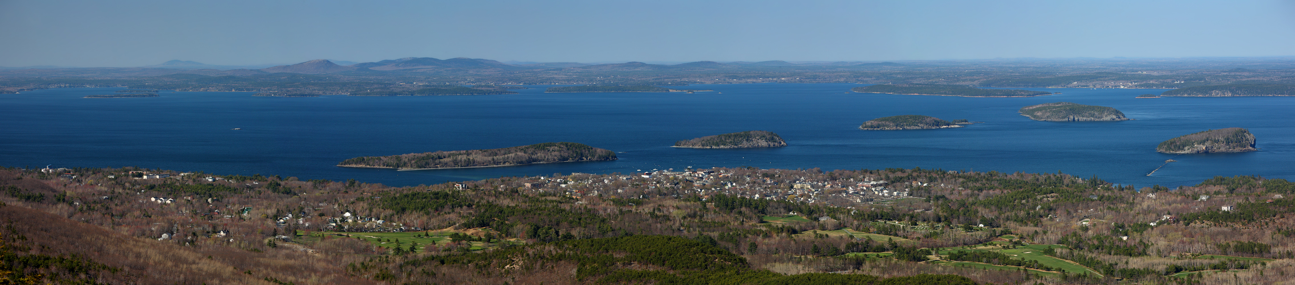
Bar Harbor is a town on Mount Desert Island in Hancock County, Maine, United States. As of the 2010 census, its population is 5,235. Bar Harbor is a popular tourist destination in the Down East region of Maine and home to the College of the Atlantic, Jackson Laboratory, and MDI Biological Laboratory (Salisbury Cove village). Prior to a catastrophic 1947 fire the town was a famous summer colony for the super-affluent elite. Bar Harbor is home to the largest parts of Acadia National Park, including Cadillac Mountain, the highest point within twenty-five miles (40 km) of the coastline of the Eastern United States.[4] The town is served by the Hancock County-Bar Harbor Airport which has flights on Cape Air and PenAir to Boston.
History[]
The town of Bar Harbor was founded on the northeast shore of Mount Desert Island, which the Wabanaki Indians knew as Pemetic, meaning "range of mountains" or "mountains seen at a distance." The Wabanaki seasonally fished, hunted and gathered berries, clams, and other shellfish in the area. They spoke of Bar Harbor as Man-es-ayd'ik ("clam-gathering place") or Ah-bays'auk ("clambake place"), leaving great piles of shells as evidence of this abundance. In early September 1604, French explorer Samuel de Champlain ran aground on a rock ledge believed to be just off Otter Cliffs, and when he came ashore to repair his boat he met local natives. Champlain named the island Isles des Monts Deserts, meaning "island of barren mountains"—now called Mount Desert Island, the largest in Maine.[5]
The community was first settled by Europeans in 1763 by Israel Higgins and John Thomas and incorporated on February 23, 1796 as Eden, after Sir Richard Eden, an English statesman. Early industries included fishing, lumbering and shipbuilding. With the best soil on Mount Desert Island, it also developed agriculture. In the 1840s, its rugged maritime scenery attracted the Hudson River School and Luminism artists Thomas Cole, Frederic Edwin Church, William Hart and Fitz Henry Lane. Inspired by their paintings, journalists, sportsmen and "rusticators" followed. Agamont House, the first hotel in Eden, was established in 1855 by Tobias Roberts. Birch Point, the first summer estate, was built in 1868 by Alpheus Hardy.
By 1880, there were 30 hotels, including the Mira Monte Inn, a historic landmark that survived a massive fire in 1947. Tourists were arriving by train and ferry to the Gilded Age resort that would rival Newport, Rhode Island. The rich and famous tried to outdo each other with entertaining and estates, often hiring landscape gardener and landscape architect Beatrix Farrand, a resident at local Reef Point Estate, to design their gardens. A glimpse of their lifestyles was available from the Shore Path, a walkway skirting waterfront lawns. Yachting, garden parties at the Pot & Kettle Club, and carriage rides up Cadillac Mountain were popular diversions. Others enjoyed horse-racing at Robin Hood Park-Morrell Park. President William Howard Taft played golf in 1910 at the Kebo Valley Golf Club. On March 3, 1918, Eden was renamed Bar Harbor, after the sand and gravel bar, visible at low tide, which leads across to Bar Island and forms the rear of the harbor. The name would become synonymous with elite wealth. It was the birthplace of vice-president Nelson Rockefeller on July 8, 1908.
Bar Harbor was also used for naval practices during World War II. More specifically, Bald Porcupine Island was used to fire live torpedoes. On October 10, 1944 it was the submarine USS Piper firing 12 live torpedoes at the island. Of the 12 torpedoes fired, one failed to explode on the first attempt but was later detonated by the 12th torpedo. In 1996, the U.S. Army Corps of Engineers surveyed the island to make sure there were no active torpedoes and only found remains.[6]
Many influential people call(ed) Bar Harbor home for at least part of the year. John D. Rockefeller, Jr., son of John D. Rockefeller of Standard Oil Co., donated about one-third of the land in Acadia National Park and built the carriage roads that are used for hiking and biking. J. P. Morgan owned a house that is adjacent to Bar Harbor. Cornelius Vanderbilt built cottages in Bar Harbor. The Astor family owned hotels and cottages in Bar Harbor and the surrounding areas. William Howard Taft used to enjoy games of golf in Bar Harbor. The co-founder and CEO of Burt's Bees, Roxanne Quimby, has a home near Bar Harbor and is seen frequenting the downtown area. The star and creator of the TV show Martha Stewart has also been known to frequent Mount Desert Island and been seen in Bar Harbor. Film star John Travolta has a home in nearby Ilesboro and has been seen many times in Bar Harbor. Architect Fred L. Savage started out on Mount Desert Island, moved, and then returned to design houses for many wealthy people in Bar Harbor.[7]
Mount Desert Island Fire[]
In mid-October 1947, Maine experienced a severe drought. Sparks at a cranberry bog near Town Hill ignited a wildfire that would intensify over ten days, and not be declared out until mid-November; this was one of several wildfires in the state that year. Nearly half the eastern side of Mount Desert Island burned, including 67 palatial summer houses on Millionaires' Row. Five historic grand hotels and 170 permanent homes were destroyed. Over 10,000 acres (40 km²) of Acadia National Park were destroyed. Fortunately, the town's business district was spared, including Mount Desert Street, where several former summer homes within a historic district listed on the National Register of Historic Places operate as inns.
Gallery[]
")
")
")
")
")
")
")
")
")
")
Geography[]
According to the United States Census Bureau, the town has a total area of 63.11 square miles (163.45 km2), of which 42.24 square miles (109.40 km2) is land and 20.87 square miles (54.05 km2) is water.[1] Bar Harbor is situated on Frenchman Bay.
Climate[]
This climatic region is typified by large seasonal temperature differences, with warm to hot (and often humid) summers and cold (sometimes severely cold) winters. According to the Köppen Climate Classification system, Bar Harbor has a humid continental climate, abbreviated "Dfb" on climate maps.[8]
Demographics[]
| Historical populations | |||
|---|---|---|---|
| Census | Pop. | %± | |
| 1800 | 400 | ||
| 1810 | 657 | 64.3% | |
| 1820 | 764 | 16.3% | |
| 1830 | 957 | 25.3% | |
| 1840 | 1,054 | 10.1% | |
| 1850 | 1,127 | 6.9% | |
| 1860 | 1,247 | 10.6% | |
| 1870 | 1,195 | −4.2% | |
| 1880 | 1,629 | 36.3% | |
| 1890 | 1,946 | 19.5% | |
| 1900 | 4,379 | 125.0% | |
| 1910 | 4,441 | 1.4% | |
| 1920 | 3,622 | −18.4% | |
| 1930 | 4,486 | 23.9% | |
| 1940 | 4,378 | −2.4% | |
| 1950 | 3,864 | −11.7% | |
| 1960 | 3,807 | −1.5% | |
| 1970 | 3,716 | −2.4% | |
| 1980 | 4,124 | 11.0% | |
| 1990 | 4,443 | 7.7% | |
| 2000 | 4,820 | 8.5% | |
| 2010 | 5,235 | 8.6% | |
| sources:[9] | |||
2010 census[]
As of the census[2] of 2010, there were 5,235 people, 2,427 households, and 1,275 families residing in the town. The population density was 123.9 inhabitants per square mile (47.8 /km2). There were 3,495 housing units at an average density of 82.7 per square mile (31.9 /km2). The racial makeup of the town was 94.7% White, 0.8% African American, 0.2% Native American, 2.8% Asian, 0.4% from other races, and 1.2% from two or more races. Hispanic or Latino of any race were 1.1% of the population.
There were 2,427 households of which 22.0% had children under the age of 18 living with them, 42.8% were married couples living together, 6.8% had a female householder with no husband present, 3.0% had a male householder with no wife present, and 47.5% were non-families. 36.0% of all households were made up of individuals and 14.6% had someone living alone who was 65 years of age or older. The average household size was 2.08 and the average family size was 2.70.
The median age in the town was 45.3 years. 17.3% of residents were under the age of 18; 10% were between the ages of 18 and 24; 22.4% were from 25 to 44; 32.3% were from 45 to 64; and 18.1% were 65 years of age or older. The gender makeup of the town was 46.3% male and 53.7% female.
2000 census[]
As of the census[10] of 2000, there were 4,820 people, 2,142 households, and 1,163 families residing in or near the town. The population density was 114.2 people per square mile (44.1/km²). There were 2,805 housing units at an average density of 66.5 per square mile (25.7/km²). The racial makeup of the town was 97.88% White, 0.15% Black or African American, 0.21% Native American, 0.89% Asian, 0.08% from other races, and 0.79% from two or more races. Hispanic or Latino of any race were 0.62% of the population.
There were 2,142 households out of which 24.5% had children under the age of 18 living with them, 44.5% were married couples living together, 6.4% had a female householder with no husband present, and 45.7% were non-families. 34.7% of all households were made up of individuals and 13.3% had someone living alone who was 65 years of age or older. The average household size was 2.16 and the average family size was 2.78.
In and near the town, the population was spread out with 19.8% under the age of 18, 9.0% from 18 to 24, 28.6% from 25 to 44, 26.6% from 45 to 64, and 16.1% who were 65 years of age or older. The median age was 41 years. For every 100 females there were 87.5 males. For every 100 females age 18 and over, there were 82.7 males.
The median income for a household in or near the town was $37,481, and the median income for a family was $51,989. Males had a median income of $31,085 versus $25,417 for females. The per capita income for the area was $24,103. About 4.9% of families and 8.9% of the population were below the poverty line, including 6.7% of those under age 18 and 8.3% of those age 65 or over.
Education[]
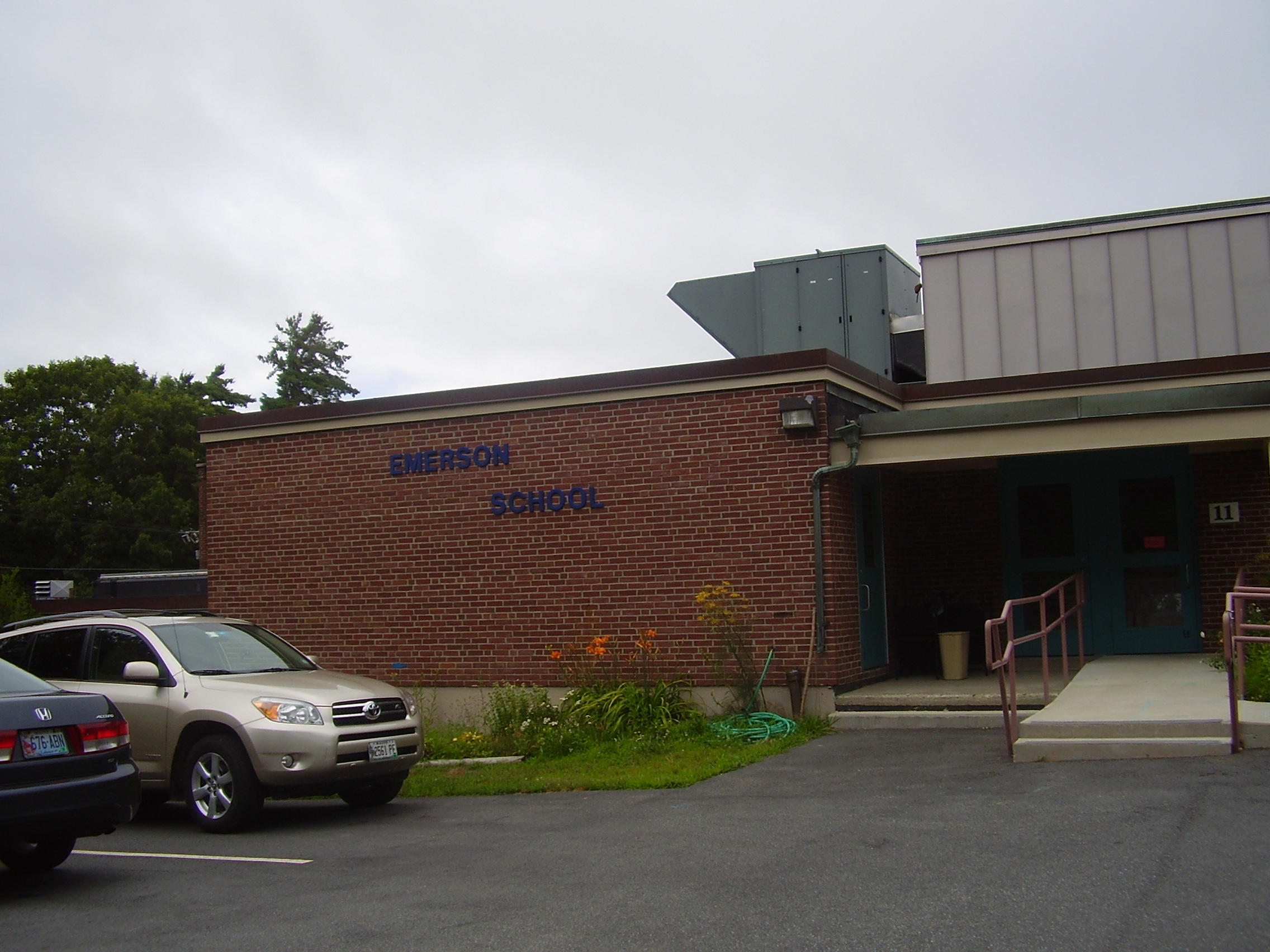

Conners Emerson School
Conners Emerson School is located in Bar Harbor.
Mount Desert Island High School (MDIHS) serves the four towns of the Island, plus the outlying islands of Swan's Island and the town of Cranberry Isles. The school also serves students from towns such as Trenton, Hancock, Lamoine, and Mariaville on the mainland.
The College of the Atlantic is located in Bar Harbor.
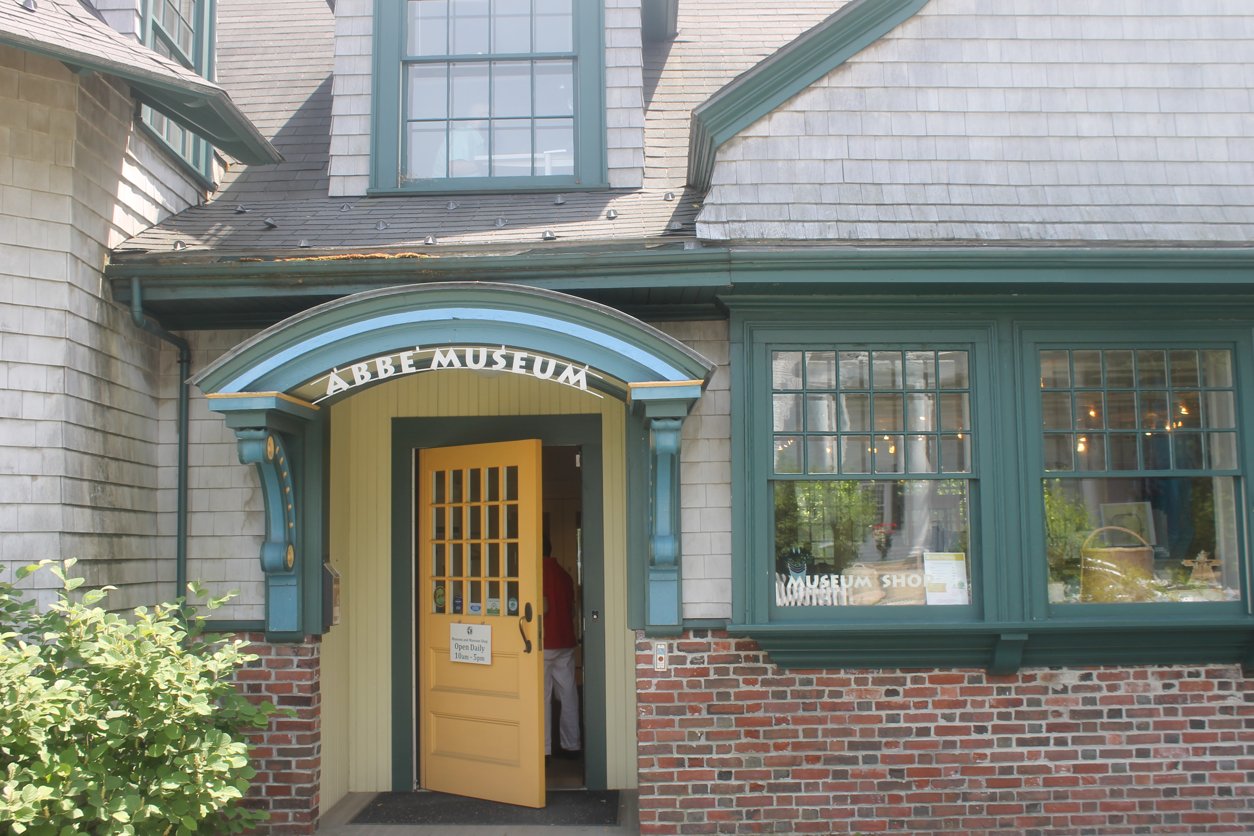

The Abbe Museum, a division of the Smithsonian Institution, is located in downtown Bar Harbor.


American Civil War monument in Bar Harbor recalls "the sons of Eden who were defenders of the Union". Eden is the former name of Bar Harbor.
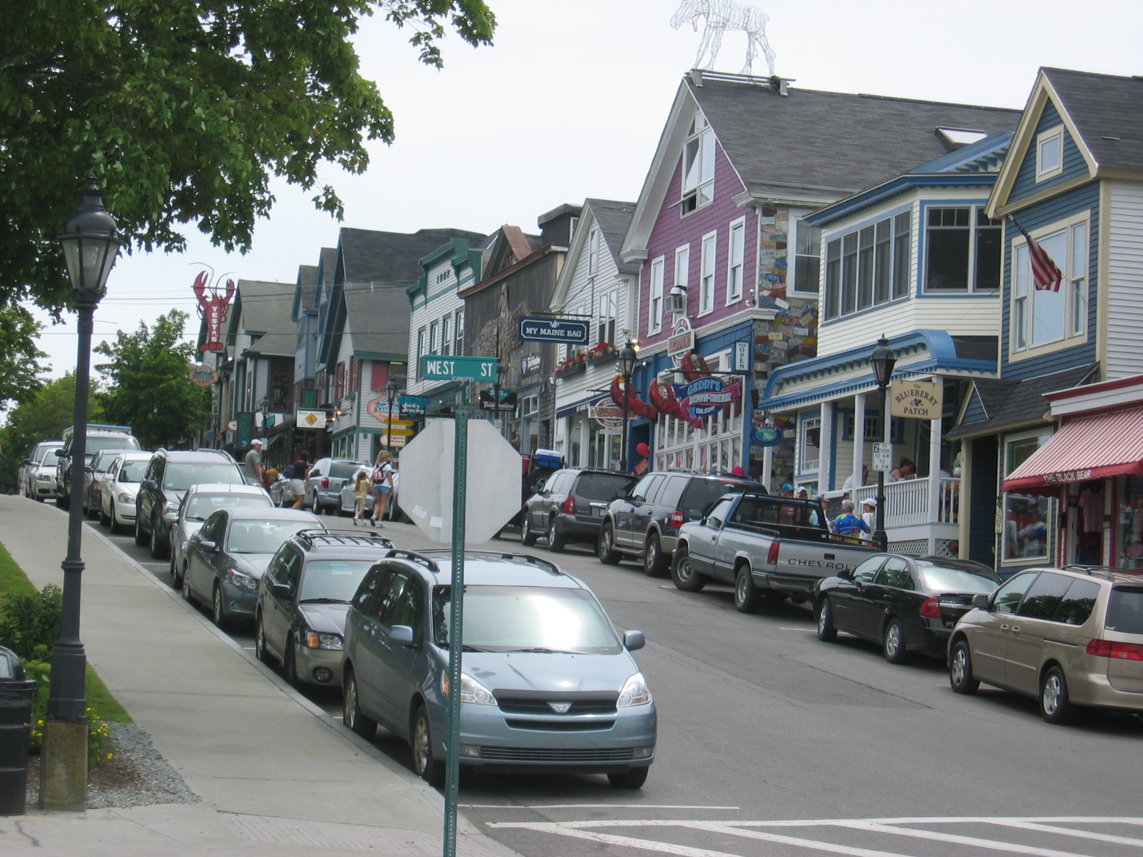
Visiting Bar Harbor[]
Many recreational activities abound in Bar Harbor. The downtown is particularly alive in the summer and autumn months because Bar Harbor is home to many outdoor enthusiasts. Since Acadia National Park is only a couple of miles from the downtown, there are plenty of chances to experience the park. Outdoor activities in Acadia include hiking along trails or carriage roads, biking along the carriage roads, bird watching, and mountain climbing, in view of Cadillac Mountain, the highest point on the Atlantic seaboard.
Those interested in the marine life surrounding Mount Desert Island can go to the marina at the end of Main Sreet. and sign up for tours that feature puffins, whales, lobster, seals, pelagic seabirds, island lighthouses, or for an overall nature cruise.
At low tide a sand bar from town to Bar Island is exposed and wide enough to drive a car across. Although cars are not allowed on the sandbar, it provides a lot of entertainment for those looking to go shelling or just to see what is uncovered when the water retreats. This exposed land also provides an excellent launch point for kayakers.
The American Planning Association in 2012 named the Village Green as one of their top ten Great Places in America for Public Spaces.[11]
Bar Harbor is a destination for tourists from all over the world. Cruise ships are in the harbor from May through October (most often in September), with 23 ships expected to make 135 visits in 2013.[12] Bar Harbor also hosts many long-distance cyclists, as it is the eastern terminus of the Adventure Cycling Association's Northern Tier Bicycle Route (which ends in Anacortes, Washington), and the northern terminus of its Atlantic Coast Bicycle Route (which ends in Key West, Florida).
Notable people[]
- Les Brewer, founder of College of the Atlantic
- Dennis Damon, state senator (2002-2010)
- Henry F. Dimock, lawyer
- William E. Dodge, Jr., businessperson
- Matthew Dunlap, Maine Secretary of State
- Jill Goldthwait, state senator (1994-2002)
- Brison D. Gooch, historian
- Carrie Jones, novelist
- Shirley Povich, sports columnist and reporter for The Washington Post
- Esther Ralston, actress
- Nelson Rockefeller, businessman and governor of New York
- Lynne Williams, lawyer, planning board member, and candidate for governor of Maine
References[]
- ^ a b "US Gazetteer files 2010". United States Census Bureau. http://www.census.gov/geo/maps-data/data/gazetteer2010.html. Retrieved 2012-12-16.
- ^ a b "American FactFinder". United States Census Bureau. http://factfinder2.census.gov/faces/nav/jsf/pages/index.xhtml. Retrieved 2012-12-16.
- ^ "Population Estimates". United States Census Bureau. http://www.census.gov/popest/data/cities/totals/2012/SUB-EST2012.html. Retrieved 2013-07-06.
- ^ "Cadillac Mountain". U.S. National Park Service. 2004-10-28. http://www.nps.gov/acad/rm/cmsub.htm. Retrieved 2008-03-22.
- ^ For a freely accessible digital text on Wabanaki culture and history, see Asticou's Island Domain: Wabanaki Peoples at Mount Desert Island 1500-2000, by Harald E. L. Prins and Bunny McBride (National Park Service, 2007)
- ^ Crocker. "Test Firing Live Torpedoes in Bar Harbor, Maine". Rowboat Media. http://www.behindbluelines.com/2012/07/09/military-monday-test-firing-live-torpedoes-in-bar-harbor-maine/. Retrieved 12/1/12.
- ^ "The Influential, The Famous & The Celebrities of Downeast Maine - Bar Harbor Maine and the Acadia National Park Regions". downeastmaineonline. http://www.downeastmaineonline.com/MaineCelebritiesFamousPeople.htm. Retrieved 12/1/12.
- ^ Climate Summary for Bar Harbor, Maine
- ^ [1], accessed March, 2010.
- ^ "American FactFinder". United States Census Bureau. http://factfinder2.census.gov. Retrieved 2008-01-31.
- ^ APA: Great Public Spaces
- ^ http://www.barharbormaine.gov/document/0002/2033.pdf
External links[]
- Town of Bar Harbor, Official website
- Bar Harbor Chamber of Commerce
 Bar Harbor travel guide from Wikivoyage
- Bar Harbour, Travel Guide by The New York Times
- Chisholm, Hugh, ed (1911). "Bar Harbor". Encyclopædia Britannica (11th ed.). Cambridge University Press.
- "Bar Harbor". Encyclopedia Americana. 1920.
| |||||||||||||||||||||||

| This page uses content from the English language Wikipedia. The original content was at Bar Harbor, Maine. The list of authors can be seen in the page history. As with this Familypedia wiki, the content of Wikipedia is available under the Creative Commons License. |