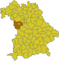
| Ansbach | |||
|---|---|---|---|
| — District — | |||
|
|||
 |
|||
| Country | |||
| State | Bavaria | ||
| Adm. region | Mittelfranken | ||
| Capital | Ansbach | ||
| Area | |||
| • Total | 1,972 km2 (761 sq mi) | ||
| Population (31 December 2010)[1] | |||
| • Total | 179,925 | ||
| • Density | 91/km2 (240/sq mi) | ||
| Time zone | CET (UTC+1) | ||
| • Summer (DST) | CEST (UTC+2) | ||
| Vehicle registration | AN | ||
| Website | landkreis-ansbach.de | ||
Ansbach District is a district in Bavaria, Germany. It is surrounding, but not including the city of Ansbach; nonetheless the administrative seat of the district is Ansbach. It is the district with the biggest area in Bavaria. The district is bounded by (from the west and clockwise) the districts Ostalb, Schwäbisch Hall and Main-Tauber (all in the state of Baden-Württemberg), and the districts of Neustadt an der Aisch-Bad Windsheim, Fürth, Roth, Weißenburg-Gunzenhausen and Donau-Ries.
History[]
Some of the towns already existed during the lifetime of Charlemagne, who visited Feuchtwangen about 800. In the 13th century the towns of Rothenburg, Dinkelsbühl and Feuchtwangen were elevated to Free Imperial Cities; so they were directly subordinate to the Holy Roman Emperor. The city of Ansbach became subject to the Hohenzollern family, who established the state of Ansbach (later Brandenburg-Ansbach) in the region.
The district of Ansbach was established in 1972, when the former districts of Ansbach, Dinkelsbühl, Feuchtwangen and Rothenburg were merged. The city of Rothenburg lost its status as an urban district and was incorporated into the district.
Geography[]
Ansbach is the largest district of Bavaria. Its northern half is occupied by the Frankenhöhe, a gentle hilly countryside. The southern parts are covered with heaths and forests. The source of the Altmühl River is located in the district.
Coat of arms[]

|
The coat of arms displays:
|
Towns and municipalities[]
| Towns (Städte) | Municipalities | |
|---|---|---|
|
|
|
References[]
- ^ "Fortschreibung des Bevölkerungsstandes" (in German). Bayerisches Landesamt für Statistik und Datenverarbeitung. 31 December 2010. https://www.statistikdaten.bayern.de/genesis/online?language=de&sequenz=tabelleErgebnis&selectionname=12411-009r&sachmerkmal=QUASTI&sachschluessel=SQUART04&startjahr=2010&endjahr=2010.
External links[]
- Official Website (German)
- Frankenhöhe (German)