| Main | Births etc |
|---|
| ||||||||||||||
| Alba | |||
|---|---|---|---|
| — County (Judet) — | |||
|
|||
 |
|||
| Country | |||
| Development region1 | Centru | ||
| Historic region | Transylvania | ||
| County seat | Alba-Iulia | ||
| Government | |||
| • Type | County Board | ||
| • President of the County Board | Ion Dumitrel (Democratic Party) | ||
| • Prefect2 | Cosmin Covaciu | ||
| Area | |||
| • Total | 6,242 km2 (2,410 sq mi) | ||
| Area rank | 16th in Romania | ||
| Population | |||
| • Total | 382,747 | ||
| • Rank | 29th in Romania | ||
| • Density | 61/km2 (160/sq mi) | ||
| Time zone | EET (UTC+2) | ||
| • Summer (DST) | EEST (UTC+3) | ||
| Postal Code | 51wxyz3 | ||
| Area code(s) | +40 x584 | ||
| Car Plates | AB5 | ||
| GDP | US$ 3.77 billion (2008) | ||
| GDP/capita | US$ 9,842 (2008) | ||
| Website | County Board County Prefecture |
||
| 1The developing regions of Romania have no administrative role. They were formed to attract funds from the European Union 2 as of 2007, the Prefect is not a politician, but a public functionary. He (or she) is not allowed to be a member of a political party, and are banned to have any political activity in the first six months after the resignation (or exclusion) from the public functionaires corp 3w, x, y, and z are digits that indicate the city, the street, part of the street, or eaven the building of the address 4x is a digit indicating the operator: 2 for the former national operator, Romtelecom, and 3 for the other ground telephone networks 5used on both the plates of the vehicles that operate only in the county limits (like utilitary vehicles & ATVs, etc.) and the ones used outside the county |
|||
Alba (Romanian pronunciation: [ˈalba]; Hungarian: Fehér) is a county (judeţ) of Romania, in Transylvania, its capital city being Alba Iulia with a population of 66,406.
Demographics[]
In 2002, it had a population of 382,747 and the population density was 61/km².
- Romanians - 90.4%[1]
- Hungarians - 5.4%
- Gipsy - 3.7%
- Germans - less than 0.3%
| Year | County population[2] |
|---|---|
| 1948 | 361,062 |
| 1956 | 370,800 |
| 1966 | 382,786 |
| 1977 | 409,634 |
| 1992 | 413,919 |
| 2002 | 382,747 |
Geography[]
This county has a total area of 6,242 km², with mountains occupying about 59% of its surface.
In the northwestern part there are the Apuseni Mountains, in the southern part there is the northeastern side of the Parâng group - Şureanu and Cindrel Mountains. In the east there is the Transylvanian Plateau with deep but wide valleys. The three main elements are separated by the Mureş River valley.
The main rivers are the Mureş River and its tributaries, the Târnava, the Sebeş and the Arieş.
Neighbours[]

- Sibiu County and Mureş County in the East.
- Bihor County and Arad County in the West.
- Cluj County in the North.
- Hunedoara County in the South-West.
Economy[]
The predominant industries in the county are:
- Food industry.
- Textile industry.
- Wood industry.
- Mechanical components.
- Paper and packaging materials industry.
- Chemical industry.
The mineral resources exploited in Alba county are metals (gold, silver, copper), salt and construction materials: marble, granite, etc.
Roşia Montanã gold mines[]

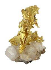
Gold in quartz, Roşia Montanã. Size 4.3 x 2.7 x 1.3 cm.
Mining began 2000 years ago on Mt. Kirnik, with well-preserved Roman galleries. A Canadian company attempted an open-pit mine, but abandoned the project around 2007. Roşia Montanã is a famous locality among mineral collectors for fine native gold specimens.[3]
Tourist attractions[]
The main tourist attractions in the county are:
- The city of Alba Iulia.
- The Apuseni Mountains.
- Scărişoara Karst Complex.
- Maidens' Fair on the Găina Mountain.
- "The Hill With Snails" west of Vidra.
- Barren Detunata and Shaggy Detunata.
- The Câlnic Castle and the Castle of Gârbova.
- The Towns and Churches of Sebeş and Aiud.
- The Ocna Mureş Resort.
- The Ţara Moţilor ethnographical area. Situated in the Apuseni Mountains, Ţara Moţilor is a region with strong Romanian traditions.
People[]
- Lucian Blaga
Administrative divisions[]
Alba County has 4 municipalities, 7 towns and 68 communes
- Municipalities
- Aiud
- Alba Iulia - county seat; 66,406 (as of 2002)
- Blaj
- Sebeş
- Towns
- Abrud
- Baia de Arieş
- Câmpeni
- Cugir
- Ocna Mureş
- Teiuş
- Zlatna
|
|
|
|
References[]
- ^ National Institute of Statistics, "Populaţia după etnie"
- ^ National Institute of Statistics, "Populaţia la recensămintele din anii 1948, 1956, 1966, 1977, 1992 şi 2002"
- ^ Roşia Montanã at Mindat.org
External links[]
| |||||||||||||
| |||||||