| ||||||||||||||
| Acadia Parish, Louisiana | |
 Location in the state of Louisiana | |
 Louisiana's location in the U.S. | |
| Founded | 1887 |
|---|---|
| Named for | The Acadians |
| Seat | Crowley |
| Largest city | Crowley |
| Area - Total - Land - Water |
658 sq mi (1,703 km²) 655 sq mi (1,697 km²) 2 sq mi (6 km²), 0.35% |
| Population - (2010) - Density |
61,773 90/sq mi (35/km²) |
| Time zone | Central: UTC-6/-5 |
Acadia Parish (French: Paroisse de l'Acadie) is a parish located in the U.S. state of Louisiana. The parish seat is Crowley. According to the 2010 census, the population of Acadia Parish is 61,773.[1] The parish was founded from parts of St. Landry Parish in 1887 after an election to determine the parish seat, ending when Crowley beat Rayne and Prairie Hayes.
Acadia Parish makes up the entire Crowley Micropolitan Statistical Area as well as part of the Lafayette–Acadiana Combined Statistical Area.[2]
History
The name of the parish is derived from the former French colony of Acadia in Canada (which consisted of the modern provinces of Nova Scotia, Prince Edward Island, New Brunswick, and much of Maine) many of whose French-speaking inhabitants were deported to France and then migrated to Louisiana in the Great Upheaval (see Cajuns).
Geography
The parish covers 658 square miles (1,700 km2), of which 655 square miles (1,700 km2) is land and 2 square miles (5.2 km2) (0.35%) is water.
Major highways
 Interstate 10
 U.S. Highway 90
- Louisiana Highway 13
- Louisiana Highway 35
Adjacent parishes
- Evangeline Parish (north)
- St. Landry Parish (northeast)
- Lafayette Parish (east)
- Vermillion Parish (south)
- Jefferson Davis Parish (west)
Demographics
| Historical populations | |||
|---|---|---|---|
| Census | Pop. | %± | |
| 1890 | 13,231 | ||
| 1900 | 23,483 | 77.5% | |
| 1910 | 31,847 | 35.6% | |
| 1920 | 34,820 | 9.3% | |
| 1930 | 39,326 | 12.9% | |
| 1940 | 46,260 | 17.6% | |
| 1950 | 47,050 | 1.7% | |
| 1960 | 49,931 | 6.1% | |
| 1970 | 52,109 | 4.4% | |
| 1980 | 56,427 | 8.3% | |
| 1990 | 55,882 | −1.0% | |
| 2000 | 58,861 | 5.3% | |
| Est. 2006 | 60,457 | [3] | 2.7% |
| Acadia Parish Census Data[4] | |||
As of the census[5] of 2000, there were 58,861 people, 21,142 households, and 15,666 families residing in the parish. The population density was 90 people per square mile (35/km²). There were 23,209 housing units at an average density of 35 per square mile (14/km²). The racial makeup of the parish was 80.73% White, 18.25% Black or African American, 0.20% Native American, 0.15% Asian, 0.01% Pacific Islander, 0.20% from other races, and 0.47% from two or more races. 0.91% of the population were Hispanic or Latino of any race. 19.04% reported speaking French or Cajun French at home.[1]
There were 21,142 households out of which 38.50% had children under the age of 18 living with them, 54.50% were married couples living together, 14.90% had a female householder with no husband present, and 25.90% were non-families. 22.60% of all households were made up of individuals and 10.30% had someone living alone who was 65 years of age or older. The average household size was 2.74 and the average family size was 3.22.
In the parish the population was spread out with 29.80% under the age of 18, 9.60% from 18 to 24, 27.40% from 25 to 44, 20.90% from 45 to 64, and 12.30% who were 65 years of age or older. The median age was 34 years. For every 100 females there were 93.50 males. For every 100 females age 18 and over, there were 88.80 males.
The median income for a household in the parish was $26,684, and the median income for a family was $31,812. Males had a median income of $29,353 versus $17,179 for females. The per capita income for the parish was $13,424. 24.50% of the population and 21.00% of families were below the poverty line. 30.30% of those under the age of 18 and 25.20% of those 65 and older were living below the poverty line.
Cities, towns, and villages
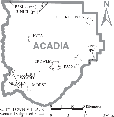

Map of Acadia Parish, Louisiana With Municipal Labels
|
|
|
|
Other Unincorporated Communities
|
More information on these communities can be found at http://www.acadia.lib.la.us/newpage1.htm
Education
Acadia Parish is served by Acadia Parish Schools [2].
Acadia Parish Library operates branches in the parish [3].
Notable natives and residents
- Paul B. Freeland coauthored Acadia Parish, Louisiana: A History to 1900. His collection of photographs and memorabilia of the Crowley area can be accessed from the archives of the Acadia Parish Library in Crowley.
- Sculptor George Stanley, famous for the design of the Oscar statue and the Muse Sculpture at the Hollywood Bowl
- Eugene Wilton Frémaux, Acadia Parish native and successful Alexandria, Louisiana businessman, entrepreneur, and civic leader.
See also
- National Register of Historic Places listings in Acadia Parish, Louisiana
References
- ^ "American FactFinder". United States Census Bureau. http://factfinder2.census.gov. Retrieved 2011-05-14.
- ^ Orszag, Peter (2009-12-01). "Bulletin 10-02 - Update of Statistical Area Definitions and Guidance on Their Uses". Office of Management and Budget. p. 73. http://www.whitehouse.gov/sites/default/files/omb/assets/bulletins/b10-02.pdf. Retrieved 2011-11-10.
- ^ United States Census Bureau. "Acadia Parish Quickfacts". http://quickfacts.census.gov/qfd/states/22/22001.html. Retrieved 2007-06-18.
- ^ United States Census Bureau. "Louisiana Population of Counties by Decennial Census: 1900 to 1990". http://www.census.gov/population/cencounts/la190090.txt. Retrieved 2007-06-18.
- ^ "American FactFinder". United States Census Bureau. http://factfinder.census.gov. Retrieved 2008-01-31.
External links
Geology
- Heinrich, P. V., J. Snead, and R. P. McCulloh, 2003, Crowley 30 x 60 minute geologic quadrangle. Louisiana Geological Survey, Baton Rouge, Louisiana.

|
Evangeline Parish | St. Landry Parish |
| |
| Jefferson Davis Parish | Lafayette Parish | |||
 Acadia Parish, Louisiana | ||||
| Vermillion Parish |
| |||||||||||||||||||||||

| ||||||||||||||||||||||||||
| This page uses content from the English language Wikipedia. The original content was at Acadia Parish, Louisiana. The list of authors can be seen in the page history. As with this Familypedia wiki, the content of Wikipedia is available under the Creative Commons License. |