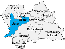
| ||||||||||||||
| Žilina District | |
|---|---|
| — District — | |
| Country | Slovakia |
| Region (kraj) | Žilina Region |
| Area | |
| • Total | 815 km2 (315 sq mi) |
| Population | |
| • Total | 158,771 (Dec. 31, 2,010) |
| Time zone | CET (UTC+1) |
| • Summer (DST) | CEST (UTC+2) |
| Telephone prefix | ? |
The Žilina District (Slovak: Okres Žilina) is an okres (district) of the Žilina Region in north-western Slovakia.
Until 1918, the district was part of the Hungarian county of Trenčín.
The core of the district is situated in the Váh river valley. Due to its urbanization, the Žilina district is one of the most developed regions of Slovakia.
Communes and towns[]
The names in bold represent towns.
|
|
| |||||||
| This page uses content from the English language Wikipedia. The original content was at Žilina District. The list of authors can be seen in the page history. As with this Familypedia wiki, the content of Wikipedia is available under the Creative Commons License. |
